
Parma, Siena, Palermo, and Trapani by Georg Braun & Frans Hogenberg. 1635

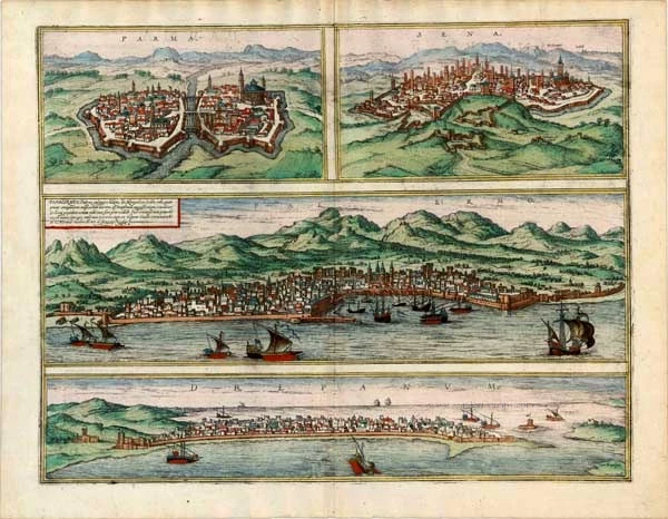


PARMA
COMMENTARY BY BRAUN: "Parma is an ancient city in Lombardy. The Parma, whose banks are linked by stone bridges, flows between the city and its suburbs. The fields around the city are pleasant and fertile, and they produce wheat, beans and other delicious fruits and various sweet, dry, white and red wines. There are also many spas and lush meadows, and cow pastures. Since they consequently have so much good milk, they supply all Italy with the cheese made here, which is called Parmesan."
Parma is shown from an elevated viewpoint. The city is divided in half by the Parma; on the right-hand side, the eye is struck by the imposing domed Romanesque cathedral of the Ascension of the Virgin with the Baptistery behind it. Behind the cathedral's apse stands the church of San Giovanni Evangelista, whose cupola is decorated inside with Correggio's fresco cycle of the Vision of St John of Patmos. In the first half of the 15th century, Parma formed part of the Papal States until the Farnese Pope Paul III created the Duchy of Parma in 1545, after which the Farnese dynasty ruled it until 1731. In the right-hand foreground is the Palazzo Ducale, remodelled in 1561 for Ottavio Farnese.
SIENA
COMMENTARY BY BRAUN: "Siena is a noble city that lies on a hill in the region of Etruria in Italy, surrounded by sandstone mountains and embellished with beautiful buildings. Amongst them is a large church to the glory of the Virgin Mary and Mother of Christ: on account of the beautiful marble in which it is clad and its exquisite and skilful construction, it can be numbered amongst the most beautiful buildings in all Europe."
Siena is seen from afar, whereby its medieval skyline of family towers gives an immediate impression of the self-confidence of a populace that found itself in artistic and economic competition with Florence and politically dependant upon Milan or the Emperor. Siena Cathedral (right), with its black and white marble, is an outstanding example of the Gothic style in central Italy. Opposite lies the pilgrims' hospice, Santa Maria Della Scala, founded around 1000, containing important 15th-century frescos. Secular power is represented by the Palazzo Pubblico with its all-overshadowing Torre del Mangia. In 1557 Siena became part of the Grand Duchy of Tuscany under Cosimo I de Medici. The Palio di Siena, a horse race between the city wards, takes place on the Piazza del Campo in July and August.
PALERMO
TRANSLATION OF CARTOUCHE TEXT: Panormus, commonly known as Palermo, largest city and capital of Sicily, whose fame is based not only on its age, the beauty of its buildings and the magnificence of its churches but also on the slaughter of the French occupying forces. From here comes the well-worn saying: When someone wished the death of many, he invokes the Sicilian Vespers.
COMMENTARY BY BRAUN: "Palermo is one of Sicily's most successful and largest cities; it lies in a favourably located attractive valley towards the north, was surrounded by walls by King Henry VI and the Tyrrhenian Sea reaches right up to the city. The Old Town has three gates and old ramparts of massive ashlars, and on one of these towers is written that Palermo is supposed to have been built during the time of Noah."
Rising above the harbour is the massive cathedral of Maria Santissima Assunta, built in the Norman-Arab style in the 12th century and continually expanded from the 14th to the 16th century. The plate records its appearance in the mid-16th century with four corner towers and Gothic spires. The crypt contains the tombs of the Hohenstaufen emperors Henry VI and Frederick II. Within Sicily's eventful history, the Hohenstaufens were responsible for flowering the arts in Palermo from 1194. The French occupying forces and Sicilian Vespers mentioned in the cartouche refer to the bloody uprising by the Sicilians against the rule of Charles I of Anjou, whom the Pope had appointed King of Sicily in 1266.
TRAPANI
COMMENTARY BY BRAUN: "The town of Drepanum lies beneath Mount Erice; eighteen miles away lie the Lilybaeum Foothills, which are separated from the city by the River Acinthium. [...] The town lies on a peninsula that curves westward and forms a strong and safe harbour. It is surrounded by numerous and large islands, making the harbour bigger."
On the west coast of Sicily, Trapani is shown from the sea, whereby the curved natural harbour explains the name of the town (Gr. Drepanum, "sickle"). In the First Punic War, a strategic base for the Carthaginians in 241 BC, Trapani was conquered by the Romans. With the arrival of the Arabs in the 9th century, the town saw an economic upswing. In 1266 it came under the rule of Charles I of Anjou and then passed to the Kingdom of Aragon. In the 15th century, it rose to become western Sicily's most important port, a position it has retained right up to the present. (Taschen)
Braun G. & Hogenberg F. and the Civitates Orbis Terrarum.
The Civitates Orbis Terrarum, or the "Braun & Hogenberg", is a six-volume town atlas and the most excellent book of town views and plans ever published: 363 engravings, sometimes beautifully coloured. It was one of the best-selling works in the last quarter of the 16th century. Georg Braun wrote the text accompanying the plans and views on the verso. Many plates were engraved after the original drawings of a professional artist, a professional artist, Joris Hoefnagel (1542-1600). The first volume was published in Latin in 1572, and the sixth in 1617. Frans Hogenberg created the tables for volumes I through IV, and Simon van den Neuwel made those for volumes V and VI. Other contributors were cartographers Daniel Freese and Heinrich Rantzau. Works by Jacob van Deventer, Sebastian Münster, and Johannes Stumpf were also used. Translations appeared in German and French.
Following the original publication of Volume 1 of the Civitates in 1572, seven further editions of 1575, 1577, 1582, 1588, 1593, 1599 and 1612 can be identified. Vol.2, first issued in 1575, was followed by further editions in 1597 and 1612. The subsequent volumes appeared in 1581, 1588, 1593, 1599 and 1606. The German translation of the first volume appeared from 1574 on, and the French edition from 1575 on.
Several printers were involved: Theodor Graminaeus, Heinrich von Aich, Gottfried von Kempen, Johannis Sinniger, Bertram Buchholtz and Peter von Brachel, who all worked in Cologne.
Georg Braun (1541-1622)
Georg Braun was born in Cologne in 1541. After his studies in Cologne, he entered the Jesuit Order as a novice. 1561, he obtained his bachelor's degree, and in 1562, he received his Magister Artium. Although he left the Jesuit Order, he studied theology, gaining a licentiate in theology.
Frans Hogenberg (1535-1590)
Frans Hogenberg was a Flemish and German painter, engraver, and mapmaker. He was born in Mechelen as the son of Nicolaas Hogenberg.
By the end of the 1560s, Frans Hogenberg was employed upon Abraham Ortelius's Theatrum Orbis Terrarum, published in 1570; he is named an engraver of numerous maps. In 1568, he was banned from Antwerp by the Duke of Alva and travelled to London, where he stayed a few years before emigrating to Cologne. He immediately embarked on his two most important works, the Civitates, published in 1572 and the Geschichtsblätter, which appeared in several series from 1569 until about 1587.
Thanks to large-scale projects like the Geschichtsblätter and the Civitates, Hogenberg's social circumstances improved with each passing year. He died as a wealthy man in Cologne in 1590.
Parma [on sheet with] Sena [and] Panhormus, Palermo vulgariter, ... [and] Drepanum
Item Number: 14655 Authenticity Guarantee
Category: Antique maps > Europe > Italy - Cities
Old, antique map of Parma, by Georg Braun & Frans Hogenberg.
Title: Parma [on sheet with] Sena [and] Panhormus, Palermo vulgariter, ... [and] Drepanum
Cum Privilegio.
Date of the first edition: 1572.
Date of this map: 1635.
Copper engraving, printed on paper.
Map size: 365 x 468mm (14.37 x 18.43 inches).
Sheet size: 410 x 530mm (16.14 x 20.87 inches).
Verso: Latin text.
Condition: Original coloured, excellent.
Condition Rating: A+.
References: Van der Krogt 4, #3323; Taschen, Br. Hog., p.118; Fauser, #10654, #12987, #10529, #14163
From: Civitates Orbis Terrarum, Liber Primus. Köln, Petrus von Brachel, 1635 (Van der Krogt 4, 41:1.1)
PARMA
COMMENTARY BY BRAUN: "Parma is an ancient city in Lombardy. The Parma, whose banks are linked by stone bridges, flows between the city and its suburbs. The fields around the city are pleasant and fertile, and they produce wheat, beans and other delicious fruits and various sweet, dry, white and red wines. There are also many spas and lush meadows, and cow pastures. Since they consequently have so much good milk, they supply all Italy with the cheese made here, which is called Parmesan."
Parma is shown from an elevated viewpoint. The city is divided in half by the Parma; on the right-hand side, the eye is struck by the imposing domed Romanesque cathedral of the Ascension of the Virgin with the Baptistery behind it. Behind the cathedral's apse stands the church of San Giovanni Evangelista, whose cupola is decorated inside with Correggio's fresco cycle of the Vision of St John of Patmos. In the first half of the 15th century, Parma formed part of the Papal States until the Farnese Pope Paul III created the Duchy of Parma in 1545, after which the Farnese dynasty ruled it until 1731. In the right-hand foreground is the Palazzo Ducale, remodelled in 1561 for Ottavio Farnese.
SIENA
COMMENTARY BY BRAUN: "Siena is a noble city that lies on a hill in the region of Etruria in Italy, surrounded by sandstone mountains and embellished with beautiful buildings. Amongst them is a large church to the glory of the Virgin Mary and Mother of Christ: on account of the beautiful marble in which it is clad and its exquisite and skilful construction, it can be numbered amongst the most beautiful buildings in all Europe."
Siena is seen from afar, whereby its medieval skyline of family towers gives an immediate impression of the self-confidence of a populace that found itself in artistic and economic competition with Florence and politically dependant upon Milan or the Emperor. Siena Cathedral (right), with its black and white marble, is an outstanding example of the Gothic style in central Italy. Opposite lies the pilgrims' hospice, Santa Maria Della Scala, founded around 1000, containing important 15th-century frescos. Secular power is represented by the Palazzo Pubblico with its all-overshadowing Torre del Mangia. In 1557 Siena became part of the Grand Duchy of Tuscany under Cosimo I de Medici. The Palio di Siena, a horse race between the city wards, takes place on the Piazza del Campo in July and August.
PALERMO
TRANSLATION OF CARTOUCHE TEXT: Panormus, commonly known as Palermo, largest city and capital of Sicily, whose fame is based not only on its age, the beauty of its buildings and the magnificence of its churches but also on the slaughter of the French occupying forces. From here comes the well-worn saying: When someone wished the death of many, he invokes the Sicilian Vespers.
COMMENTARY BY BRAUN: "Palermo is one of Sicily's most successful and largest cities; it lies in a favourably located attractive valley towards the north, was surrounded by walls by King Henry VI and the Tyrrhenian Sea reaches right up to the city. The Old Town has three gates and old ramparts of massive ashlars, and on one of these towers is written that Palermo is supposed to have been built during the time of Noah."
Rising above the harbour is the massive cathedral of Maria Santissima Assunta, built in the Norman-Arab style in the 12th century and continually expanded from the 14th to the 16th century. The plate records its appearance in the mid-16th century with four corner towers and Gothic spires. The crypt contains the tombs of the Hohenstaufen emperors Henry VI and Frederick II. Within Sicily's eventful history, the Hohenstaufens were responsible for flowering the arts in Palermo from 1194. The French occupying forces and Sicilian Vespers mentioned in the cartouche refer to the bloody uprising by the Sicilians against the rule of Charles I of Anjou, whom the Pope had appointed King of Sicily in 1266.
TRAPANI
COMMENTARY BY BRAUN: "The town of Drepanum lies beneath Mount Erice; eighteen miles away lie the Lilybaeum Foothills, which are separated from the city by the River Acinthium. [...] The town lies on a peninsula that curves westward and forms a strong and safe harbour. It is surrounded by numerous and large islands, making the harbour bigger."
On the west coast of Sicily, Trapani is shown from the sea, whereby the curved natural harbour explains the name of the town (Gr. Drepanum, "sickle"). In the First Punic War, a strategic base for the Carthaginians in 241 BC, Trapani was conquered by the Romans. With the arrival of the Arabs in the 9th century, the town saw an economic upswing. In 1266 it came under the rule of Charles I of Anjou and then passed to the Kingdom of Aragon. In the 15th century, it rose to become western Sicily's most important port, a position it has retained right up to the present. (Taschen)
Braun G. & Hogenberg F. and the Civitates Orbis Terrarum.
The Civitates Orbis Terrarum, or the "Braun & Hogenberg", is a six-volume town atlas and the most excellent book of town views and plans ever published: 363 engravings, sometimes beautifully coloured. It was one of the best-selling works in the last quarter of the 16th century. Georg Braun wrote the text accompanying the plans and views on the verso. Many plates were engraved after the original drawings of a professional artist, a professional artist, Joris Hoefnagel (1542-1600). The first volume was published in Latin in 1572, and the sixth in 1617. Frans Hogenberg created the tables for volumes I through IV, and Simon van den Neuwel made those for volumes V and VI. Other contributors were cartographers Daniel Freese and Heinrich Rantzau. Works by Jacob van Deventer, Sebastian Münster, and Johannes Stumpf were also used. Translations appeared in German and French.
Following the original publication of Volume 1 of the Civitates in 1572, seven further editions of 1575, 1577, 1582, 1588, 1593, 1599 and 1612 can be identified. Vol.2, first issued in 1575, was followed by further editions in 1597 and 1612. The subsequent volumes appeared in 1581, 1588, 1593, 1599 and 1606. The German translation of the first volume appeared from 1574 on, and the French edition from 1575 on.
Several printers were involved: Theodor Graminaeus, Heinrich von Aich, Gottfried von Kempen, Johannis Sinniger, Bertram Buchholtz and Peter von Brachel, who all worked in Cologne.
Georg Braun (1541-1622)
Georg Braun was born in Cologne in 1541. After his studies in Cologne, he entered the Jesuit Order as a novice. 1561, he obtained his bachelor's degree, and in 1562, he received his Magister Artium. Although he left the Jesuit Order, he studied theology, gaining a licentiate in theology.
Frans Hogenberg (1535-1590)
Frans Hogenberg was a Flemish and German painter, engraver, and mapmaker. He was born in Mechelen as the son of Nicolaas Hogenberg.
By the end of the 1560s, Frans Hogenberg was employed upon Abraham Ortelius's Theatrum Orbis Terrarum, published in 1570; he is named an engraver of numerous maps. In 1568, he was banned from Antwerp by the Duke of Alva and travelled to London, where he stayed a few years before emigrating to Cologne. He immediately embarked on his two most important works, the Civitates, published in 1572 and the Geschichtsblätter, which appeared in several series from 1569 until about 1587.
Thanks to large-scale projects like the Geschichtsblätter and the Civitates, Hogenberg's social circumstances improved with each passing year. He died as a wealthy man in Cologne in 1590.