
Rare!
Brabant by Pieter Verbiest 1628
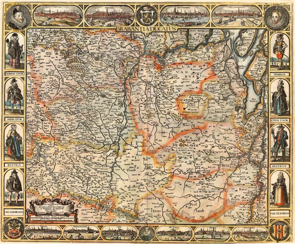


EXTREMELY RARE MAP OF BRABANT, BY PIETER VERBIEST. The first title in capitals appears in the centre below the top border; a second title, including the publisher's name and the date of issue, is in a cartouche in the lower left corner. The map is framed on four sides by town views, costumed figures, portraits and coats of arms. Top border: Albertus D.G. Archidux Austriae ... (portrait) - Leuven - Bruxel - Insigne Ducatus Brabantiae (coat of arms) - Antwerpen - s'Hertogenbosch - Isabella Clara ... (portrait). Bottom border: Marchionatus Sacri Impery Insigne (coat of arms) - Tienen - Bergen op Zoom - Lier - Son. Excellentie Marquis Spinola (portrait) - Helmondt - Breda - Mechelen ) - Insigne Dominy Mechliniensis (coat of arms). Costumed figures of the different social classes frame the side borders of the map. One recorded copy of this first edition with decorative borders. States according to Dorigo-Franssen: 1st state: 1628 - 3 recorded copies: Tilburg, Bibl. Kath. Univ. Brabant; Paris, Bibl. Nat. (without borders); Vilnius VUB (Without bottom border). 2nd state: dated 1628 but between c. 1633 and 1637): Some cartographic changes and the course of the Maas is extended into the edge. - 1 recorded copy: Private Coll. Oomen. 3rd state: 1637 - 2 recorded copies: Brussel, Kon. Bibl.; Paris, Bibl. Nat. (without borders) 4th state: 1647 - 1 recorded copy: Our copy, now in Belgian private coll. 5th state: 1666 - 2 recorded copies: Paris, Bibl. Nat.; Private foundation (formerly Stopp)
Pieter Verbiest (Petrus Verbist) and Isaak Verbiest (Isack Verbist)
Pieter Verbiest (Antwerpen, 1607-1674) was an Antwerp cartographer and engraver. Little is known about his life.
One of his most important works is the Novus Tabularum Geographicorum Belgicae (Antwerp, 1636), a pocket atlas of which two more editions were published later (1644 and 1652). Isaak Verbiest, probably a brother of Pieter, drew and engraved certain maps. Their collaboration also led to the production of two rare world maps.
Pieter Verbiest also published folio maps as separate publications. Koeman describes three editions of a Verbiest atlas of the Netherlands, published between 1636 and 1652. Only one copy of each of these atlases is known.
Verbiest-maps, some with beautiful decorative borders with city views, costumed figures and coats of arms, were sometimes bound in composite atlases. Occasionally, copies of these scarce maps come onto the market.
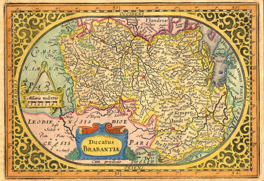
Brabantia Ducatus / Tabula Ducatus Brabantiae Continens Marchionatum Sacri Imperij et Dominium Mechliniense - Magna Cura edita à Petri Verbist Anno 1628.
Item Number: 27743 Authenticity Guarantee
Category: Antique maps > Europe > The Netherlands
Old, antique map of Brabant by Pieter Verbiest.
Title: Brabantia Ducatus / Tabula Ducatus Brabantiae Continens Marchionatum Sacri Imperij et Dominium Mechliniense - Magna Cura edita à Petri Verbist Anno 1628.
Engraver: Pieter Verbiest.
Date of the first edition: 1628.
Date of this map: 1628.
Date on map: 1628.
Copper engraving, printed on paper.
Size (not including margins): 465 x 555mm (18.31 x 21.85 inches).
Verso: Blank.
Condition: Original coloured, two additional vertical folds, small reinforcement to lower right folds at the back, short margins. Good copy.
.
Condition Rating: A.
Separate publication. From a composite atlas published c. 1630.
First state - only one copy with borders recorded.
EXTREMELY RARE MAP OF BRABANT, BY PIETER VERBIEST. The first title in capitals appears in the centre below the top border; a second title, including the publisher's name and the date of issue, is in a cartouche in the lower left corner. The map is framed on four sides by town views, costumed figures, portraits and coats of arms. Top border: Albertus D.G. Archidux Austriae ... (portrait) - Leuven - Bruxel - Insigne Ducatus Brabantiae (coat of arms) - Antwerpen - s'Hertogenbosch - Isabella Clara ... (portrait). Bottom border: Marchionatus Sacri Impery Insigne (coat of arms) - Tienen - Bergen op Zoom - Lier - Son. Excellentie Marquis Spinola (portrait) - Helmondt - Breda - Mechelen ) - Insigne Dominy Mechliniensis (coat of arms). Costumed figures of the different social classes frame the side borders of the map. One recorded copy of this first edition with decorative borders. States according to Dorigo-Franssen: 1st state: 1628 - 3 recorded copies: Tilburg, Bibl. Kath. Univ. Brabant; Paris, Bibl. Nat. (without borders); Vilnius VUB (Without bottom border). 2nd state: dated 1628 but between c. 1633 and 1637): Some cartographic changes and the course of the Maas is extended into the edge. - 1 recorded copy: Private Coll. Oomen. 3rd state: 1637 - 2 recorded copies: Brussel, Kon. Bibl.; Paris, Bibl. Nat. (without borders) 4th state: 1647 - 1 recorded copy: Our copy, now in Belgian private coll. 5th state: 1666 - 2 recorded copies: Paris, Bibl. Nat.; Private foundation (formerly Stopp)
Pieter Verbiest (Petrus Verbist) and Isaak Verbiest (Isack Verbist)
Pieter Verbiest (Antwerpen, 1607-1674) was an Antwerp cartographer and engraver. Little is known about his life.
One of his most important works is the Novus Tabularum Geographicorum Belgicae (Antwerp, 1636), a pocket atlas of which two more editions were published later (1644 and 1652). Isaak Verbiest, probably a brother of Pieter, drew and engraved certain maps. Their collaboration also led to the production of two rare world maps.
Pieter Verbiest also published folio maps as separate publications. Koeman describes three editions of a Verbiest atlas of the Netherlands, published between 1636 and 1652. Only one copy of each of these atlases is known.
Verbiest-maps, some with beautiful decorative borders with city views, costumed figures and coats of arms, were sometimes bound in composite atlases. Occasionally, copies of these scarce maps come onto the market.
Related items
Brabantia Ducatus / Tabula Ducatus Brabantiae Continens Marchionatum Sacri Imperij et Dominium Mechliniense Magna cura edita à Nicolao Iohannis Visscher. Anno 1622. 1622
Brabant by C.J. Visscher.
[Item number: 2640]
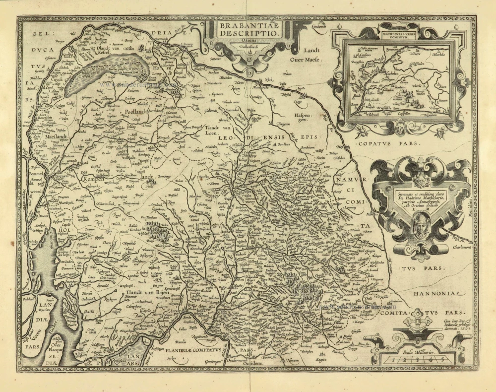
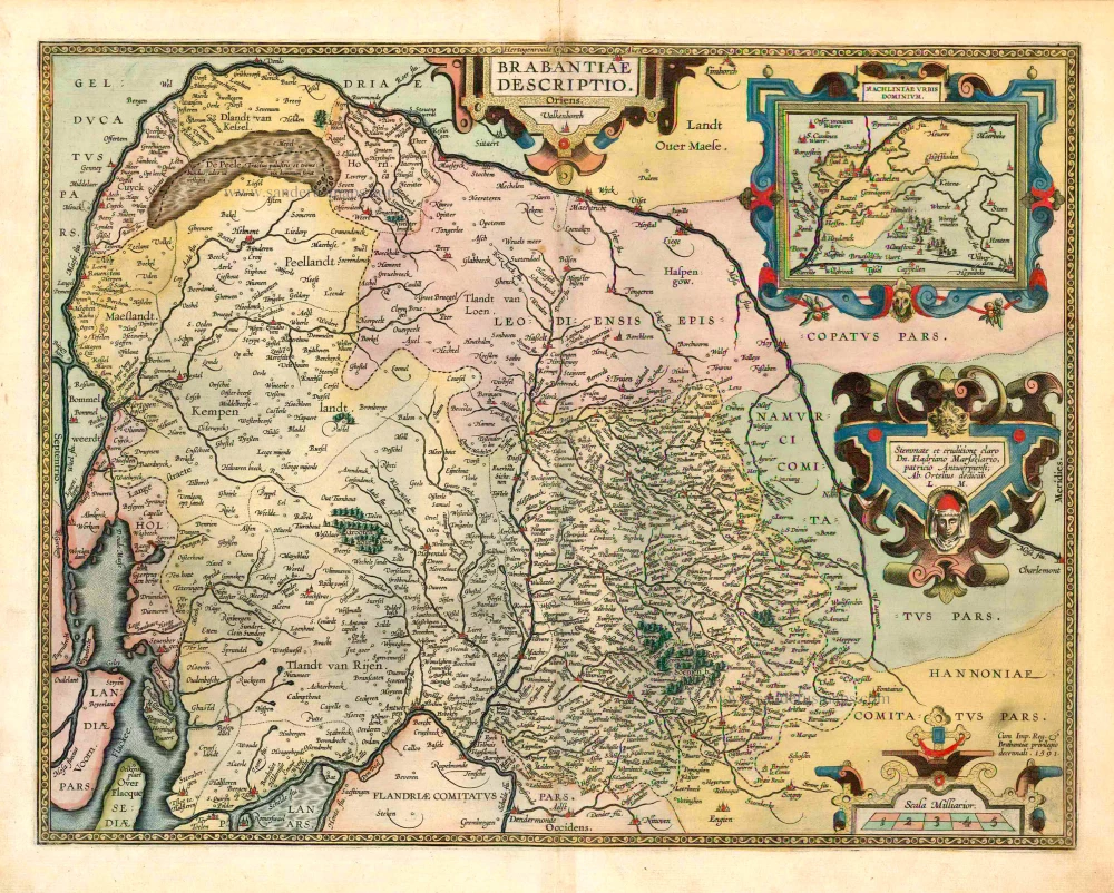
Brabantiae Descriptio 1601
Brabant, with an inset map of the district of Mechelen, by Abraham Ortelius.
[Item number: 12909]
Ducatus Brabantiae. 1631
Brabant by Abraham Goos,published by Joannes Janssonius.
[Item number: 17723]

Novissima et Accuratissima Brabantiae Ducatus Tabula. 1638
Brabant by Henricus Hondius, published by J. Janssonius.
[Item number: 19012]
Brabantia Ducatus. 1647-50
Brabant, by W. Blaeu.
[Item number: 22657]
Brabantiae Belgarum provinciae recens exactaque descriptio. 1602
Brabant by M. Quad - J. Bussemacher.
[Item number: 25235]
Brabantiae Descriptio. 1595
Brabant, by A. Ortelius.
[Item number: 25573]

Important and rare map.
Brabantiae Belgarum Provinciae Recens Exactaque Descriptio. 1558
Brabant, by Michele Tramezini.
[Item number: 26713]
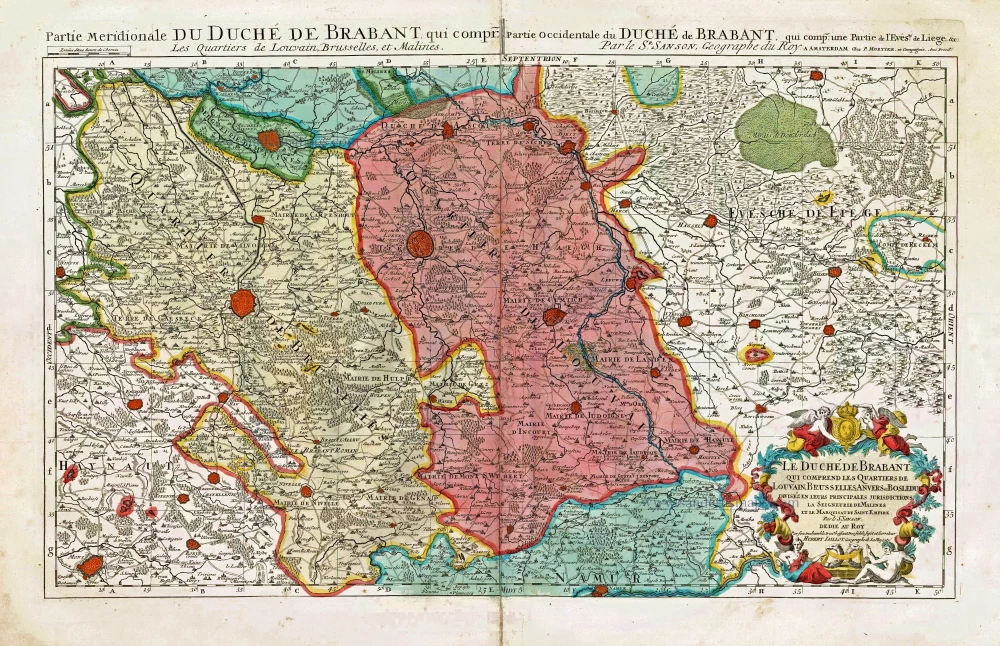
Le Duché de Brabant qui comprend les Quartiers de Louvain, Brusselles, Anvers et Bosleduc divizés en lerus Principales Jurisdictions, La Seigneurie de Malines et le Marquisat du Saint Empire. c. 1705
Northern Brabant, by Pieter Mortier.
[Item number: 27801]
First edition, woodcut
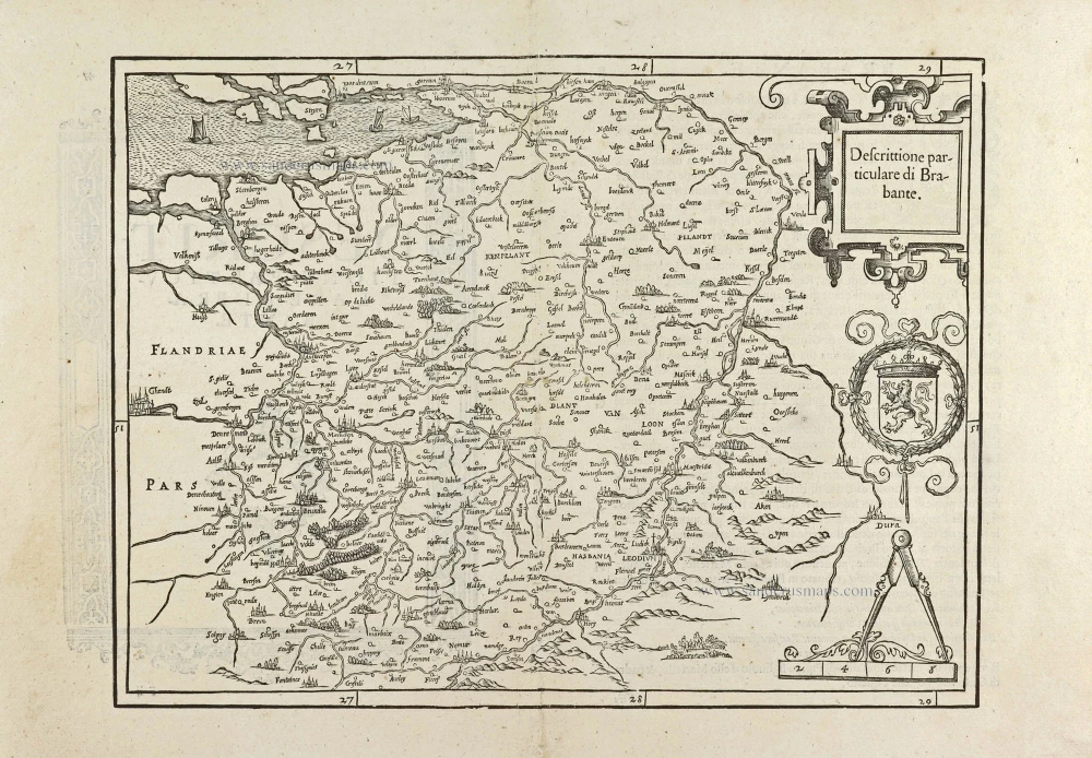
Descrittione particulare di Brabante. 1567
Brabant by Lodovico Guicciardini.
[Item number: 29504]
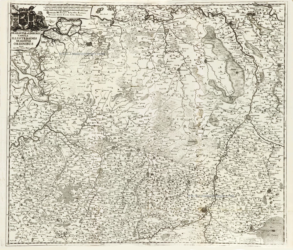
Exactissima Brabantiae et Limburgi Tabula Illustrissimis Brabantiae Ordinibus. 1712
Brabant & Zuid Limburg by Eugene Fricx.
[Item number: 29546]

Ducatus Brabantiae Nova Tabula in qua Lovanii Bruxellarum March S. Imperii Sulvaeu Ducis et Mechliniae Dominia c. 1730-37
Brabant by Johann Baptist Homann.
[Item number: 30250]
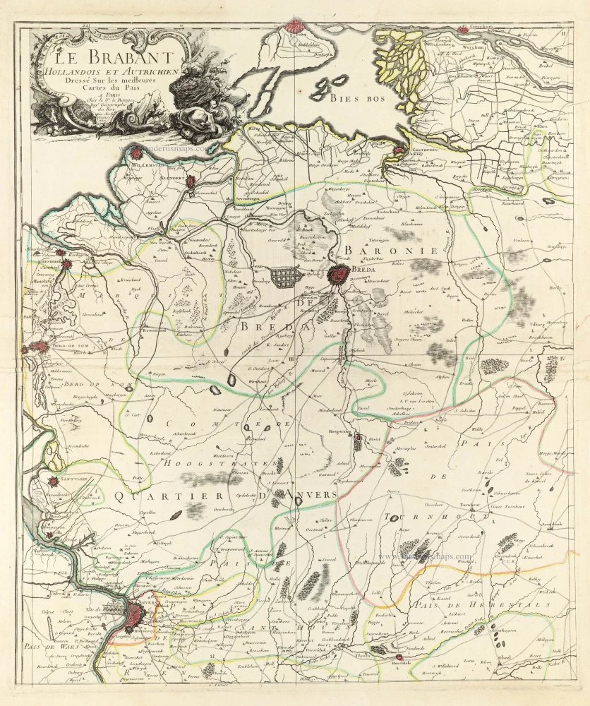
Le Brabant Hollandois et Autrichien. 1747
Northwest Brabant by G.L. Le Rouge.
[Item number: 30255]
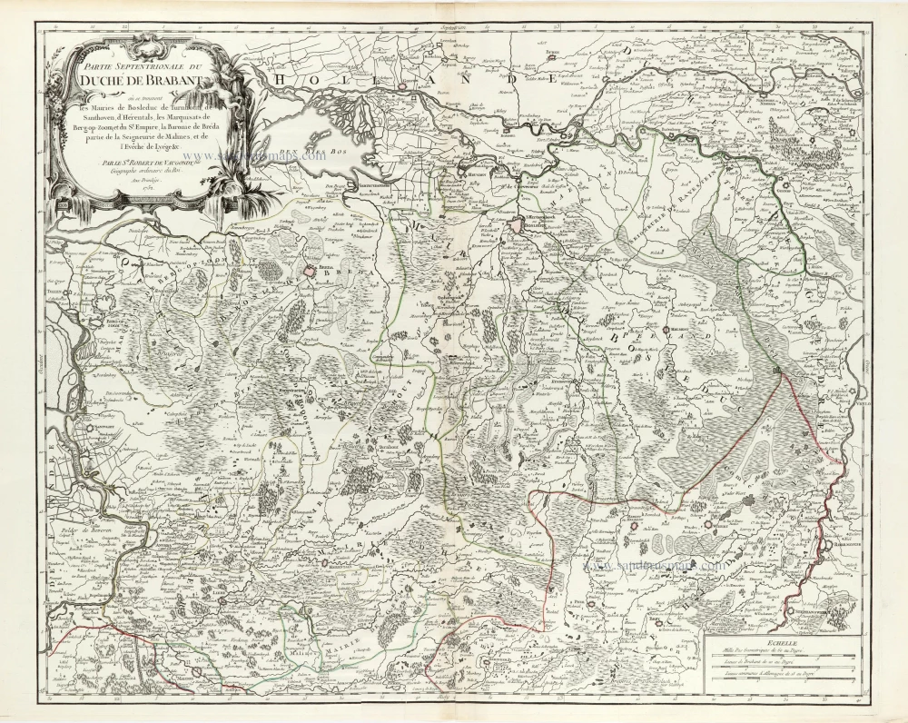
Partie Septentrionale du Duché de Brabant où se trouvent les Mairies de Bosleduc de Turnhout, de Santhoven, d'Herentals, les Marquisats de Berg-op-Zoom, et du St Empire, la Baronie de Bréda partie de la Seigneurie de Malines, et de l'Evêché de Lyége &c. 1757
Southern Brabant par Robert de Vaugondy.
[Item number: 30403]
new
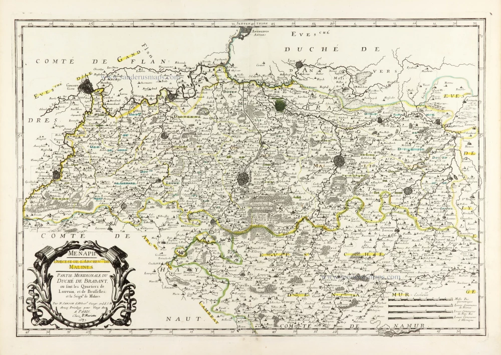
Menapii. Dioecese de l'Archev[es]ché de Malines. Partie meridionale du Duché de Brabant, ou sont les quartiers de Louvain, et du Brusselles; et la seign[eu]rie de Malines. 1679-1710
Historical map of Southern Brabant, by Guillaume Sanson, published by P. Mariette.
[Item number: 30520]
new

Tabula Ducatus Brabantiae continens Marchionatum Sacri Imperiii et Dominium Mechliniense 1670-71
Brabant by Frederick De Wit.
[Item number: 30526]
new