
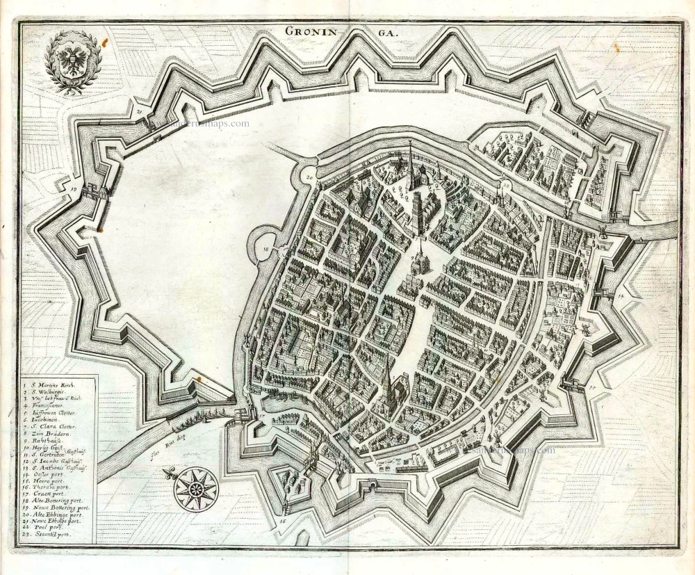
Groningen by Braun & Hogenberg 1582
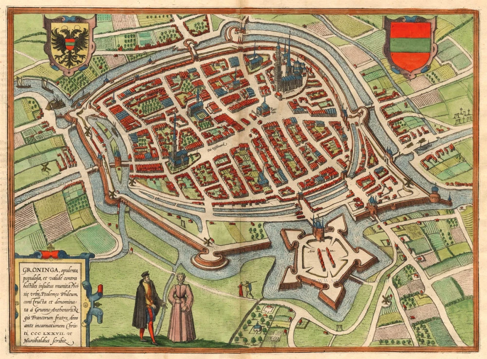
TRANSLATION OF CARTOUCHE TEXT: Groningen, a wealthy and populous Frisian city, strongly fortified against enemy attacks, referred to by Ptolemy as Phileum; built and named by Grunno, brother of the Frankish king Anthenor in AD 377, as written by Hunibald.
COMMENTARY BY BRAUN (on verso): "The water is conducted in and through the city in enormous canals built largely by human architecture and artisanship. It is a spacious city with its own laws and rules, and has authority over many surrounding villages. The city itself possesses many fiefs."
The Old Town is surrounded by canals and dominated by the Grote Markt with the town hall and Martinikerk, and by the fish market with the Aakerk. Both churches were originally built in the 13th century, but were altered and expanded in the 15th century. To the former belongs the 97-m-high Martinitoren, known locally as the "Old Grey One".
In the 13th century the city attained great importance because of its favourable position, and it became a Hanseatic city in 1282. Many merchants settled here and Groningen developed into a flourishing trade centre. In 1536 the city passed first to the Habsburgs and finally in 1594 to the United Netherlands. In 1614 the university was founded. (Taschen)
Braun G. & Hogenberg F. and the Civitates Orbis Terrarum.
The Civitates Orbis Terrarum, or the "Braun & Hogenberg", is a six-volume town atlas and the most excellent book of town views and plans ever published: 363 engravings, sometimes beautifully coloured. It was one of the best-selling works in the last quarter of the 16th century. Georg Braun wrote the text accompanying the plans and views on the verso. Many plates were engraved after the original drawings of a professional artist, a professional artist, Joris Hoefnagel (1542-1600). The first volume was published in Latin in 1572, and the sixth in 1617. Frans Hogenberg created the tables for volumes I through IV, and Simon van den Neuwel made those for volumes V and VI. Other contributors were cartographers Daniel Freese and Heinrich Rantzau. Works by Jacob van Deventer, Sebastian Münster, and Johannes Stumpf were also used. Translations appeared in German and French.
Following the original publication of Volume 1 of the Civitates in 1572, seven further editions of 1575, 1577, 1582, 1588, 1593, 1599 and 1612 can be identified. Vol.2, first issued in 1575, was followed by further editions in 1597 and 1612. The subsequent volumes appeared in 1581, 1588, 1593, 1599 and 1606. The German translation of the first volume appeared from 1574 on, and the French edition from 1575 on.
Several printers were involved: Theodor Graminaeus, Heinrich von Aich, Gottfried von Kempen, Johannis Sinniger, Bertram Buchholtz and Peter von Brachel, who all worked in Cologne.
Georg Braun (1541-1622)
Georg Braun was born in Cologne in 1541. After his studies in Cologne, he entered the Jesuit Order as a novice. 1561, he obtained his bachelor's degree, and in 1562, he received his Magister Artium. Although he left the Jesuit Order, he studied theology, gaining a licentiate in theology.
Frans Hogenberg (1535-1590)
Frans Hogenberg was a Flemish and German painter, engraver, and mapmaker. He was born in Mechelen as the son of Nicolaas Hogenberg.
By the end of the 1560s, Frans Hogenberg was employed upon Abraham Ortelius's Theatrum Orbis Terrarum, published in 1570; he is named an engraver of numerous maps. In 1568, he was banned from Antwerp by the Duke of Alva and travelled to London, where he stayed a few years before emigrating to Cologne. He immediately embarked on his two most important works, the Civitates, published in 1572 and the Geschichtsblätter, which appeared in several series from 1569 until about 1587.
Thanks to large-scale projects like the Geschichtsblätter and the Civitates, Hogenberg's social circumstances improved with each passing year. He died as a wealthy man in Cologne in 1590.
Groninga, opulenta, populosa, et valide contra hostiles insultus munita Phrisie urbs, ...
Item Number: 17834 Authenticity Guarantee
Category: Antique maps > Europe > The Netherlands - Cities
Antique map - bird's-eye view plan of Groningen by Braun and Hogenberg.
TRANSLATION OF CARTOUCHE TEXT: Groningen, a wealthy and populous Frisian city, strongly fortified against enemy attacks, referred to by Ptolemy as Phileum; built and named by Grunno, brother of the Frankish king Anthenor in AD 377, as written by Hunibald.
COMMENTARY BY BRAUN (on verso): "The water is conducted in and through the city in enormous canals built largely by human architecture and artisanship. It is a spacious city with its own laws and rules, and has authority over many surrounding villages. The city itself possesses many fiefs."
The Old Town is surrounded by canals and dominated by the Grote Markt with the town hall and Martinikerk, and by the fish market with the Aakerk. Both churches were originally built in the 13th century, but were altered and expanded in the 15th century. To the former belongs the 97-m-high Martinitoren, known locally as the "Old Grey One".
In the 13th century the city attained great importance because of its favourable position, and it became a Hanseatic city in 1282. Many merchants settled here and Groningen developed into a flourishing trade centre. In 1536 the city passed first to the Habsburgs and finally in 1594 to the United Netherlands. In 1614 the university was founded. (Taschen)
Date of the first edition: 1575
Date of this map: 1582
Copper engraving
Size: 32 x 43.5cm (12.5 x 17 inches)
Verso text: Latin
Condition: Coloured.
Condition Rating: A
References: Van der Krogt 4, 1645; Taschen, Braun and Hogenberg, p.162.
From: Civitates Orbis Terrarum, Liber Secundus. Köln, Gottfried von Kempen, 1582. (Van der Krogt 4, 41:1.2)
TRANSLATION OF CARTOUCHE TEXT: Groningen, a wealthy and populous Frisian city, strongly fortified against enemy attacks, referred to by Ptolemy as Phileum; built and named by Grunno, brother of the Frankish king Anthenor in AD 377, as written by Hunibald.
COMMENTARY BY BRAUN (on verso): "The water is conducted in and through the city in enormous canals built largely by human architecture and artisanship. It is a spacious city with its own laws and rules, and has authority over many surrounding villages. The city itself possesses many fiefs."
The Old Town is surrounded by canals and dominated by the Grote Markt with the town hall and Martinikerk, and by the fish market with the Aakerk. Both churches were originally built in the 13th century, but were altered and expanded in the 15th century. To the former belongs the 97-m-high Martinitoren, known locally as the "Old Grey One".
In the 13th century the city attained great importance because of its favourable position, and it became a Hanseatic city in 1282. Many merchants settled here and Groningen developed into a flourishing trade centre. In 1536 the city passed first to the Habsburgs and finally in 1594 to the United Netherlands. In 1614 the university was founded. (Taschen)
Braun G. & Hogenberg F. and the Civitates Orbis Terrarum.
The Civitates Orbis Terrarum, or the "Braun & Hogenberg", is a six-volume town atlas and the most excellent book of town views and plans ever published: 363 engravings, sometimes beautifully coloured. It was one of the best-selling works in the last quarter of the 16th century. Georg Braun wrote the text accompanying the plans and views on the verso. Many plates were engraved after the original drawings of a professional artist, a professional artist, Joris Hoefnagel (1542-1600). The first volume was published in Latin in 1572, and the sixth in 1617. Frans Hogenberg created the tables for volumes I through IV, and Simon van den Neuwel made those for volumes V and VI. Other contributors were cartographers Daniel Freese and Heinrich Rantzau. Works by Jacob van Deventer, Sebastian Münster, and Johannes Stumpf were also used. Translations appeared in German and French.
Following the original publication of Volume 1 of the Civitates in 1572, seven further editions of 1575, 1577, 1582, 1588, 1593, 1599 and 1612 can be identified. Vol.2, first issued in 1575, was followed by further editions in 1597 and 1612. The subsequent volumes appeared in 1581, 1588, 1593, 1599 and 1606. The German translation of the first volume appeared from 1574 on, and the French edition from 1575 on.
Several printers were involved: Theodor Graminaeus, Heinrich von Aich, Gottfried von Kempen, Johannis Sinniger, Bertram Buchholtz and Peter von Brachel, who all worked in Cologne.
Georg Braun (1541-1622)
Georg Braun was born in Cologne in 1541. After his studies in Cologne, he entered the Jesuit Order as a novice. 1561, he obtained his bachelor's degree, and in 1562, he received his Magister Artium. Although he left the Jesuit Order, he studied theology, gaining a licentiate in theology.
Frans Hogenberg (1535-1590)
Frans Hogenberg was a Flemish and German painter, engraver, and mapmaker. He was born in Mechelen as the son of Nicolaas Hogenberg.
By the end of the 1560s, Frans Hogenberg was employed upon Abraham Ortelius's Theatrum Orbis Terrarum, published in 1570; he is named an engraver of numerous maps. In 1568, he was banned from Antwerp by the Duke of Alva and travelled to London, where he stayed a few years before emigrating to Cologne. He immediately embarked on his two most important works, the Civitates, published in 1572 and the Geschichtsblätter, which appeared in several series from 1569 until about 1587.
Thanks to large-scale projects like the Geschichtsblätter and the Civitates, Hogenberg's social circumstances improved with each passing year. He died as a wealthy man in Cologne in 1590.
Related items
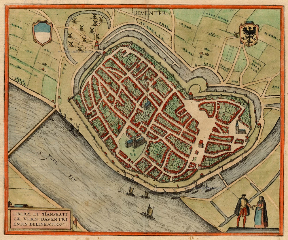
Deventer - Liberae et Hanseaticae Urbis Daventriensis Delineatio 1581-88
Deventer, by Georg Braun and Frans Hogenberg.
[Item number: 2803]
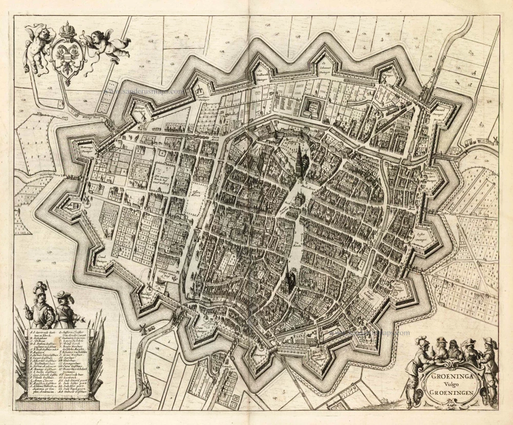
Groeninga Vulgo Groeningen 1657
Groningen, by Johannes Janssonius.
[Item number: 5163]

Groninga, opulenta, populosa, et valide contra hostiles insultus munita Phrisie urbs, ... 1575
Groningen, by Georg Braun and Frans Hogenberg.
[Item number: 8108]
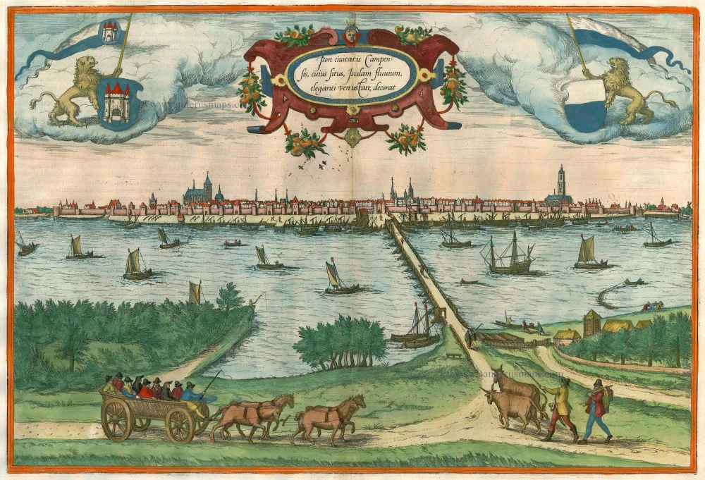
Icon civitatis Campensis, cuius situs Isulam fluvium, eleganti venustate, decorat 1575
Kampen, by Georg Braun and Frans Hogenberg.
[Item number: 9364]
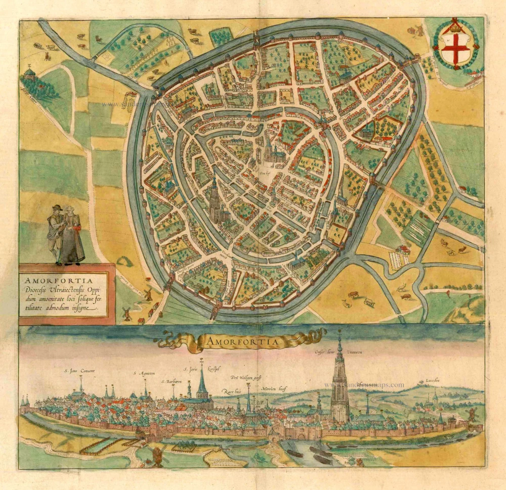
Amorfortia Diocesis Ultraiectensis Oppidum amoenitate loci solique fertilitate admodum insigne. c. 1593
Amersfoort by Braun Georg & Hogenberg Frans
[Item number: 15424]
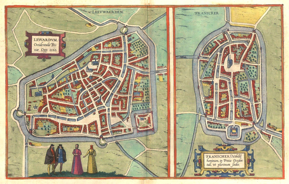
Lewardum. Occidentalis Frisiae Opp: 1580. [on sheet with:] Franicher, Nobiliu hominum, in Frisia Occidentali, ut plurimum saedes. 1581-88
Leeuwarden & Franeker by Braun & Hogenberg.
[Item number: 20439]
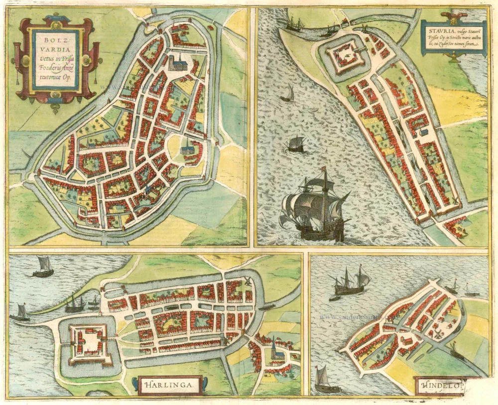
Bolzvardia vetus in Frisia Foederis Anzae teurinicae Op. [on sheet with] Stavria, vulgo Stavere ... [and] Harlinga [and] Hindelop. 1599
Bolsward, Stavoren, Harlingen, Hindelopen by Braun & Hogenberg.
[Item number: 22261]
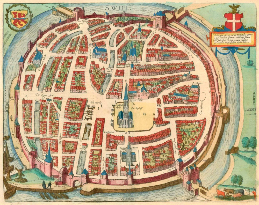
Swolla diu celebris meruit virtutibus Arma: ... 1599
Zwolle, by Georg Braun and Frans Hogenberg.
[Item number: 23318]
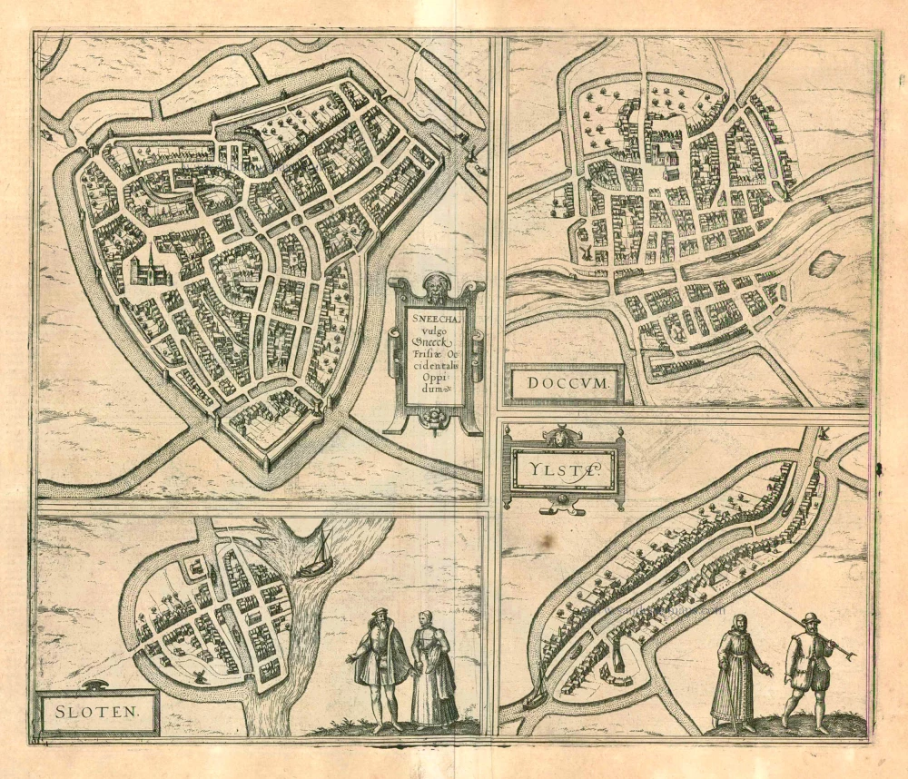
Sneecha, vulgo Sneeck ... [on sheet with] Doccum [and] Sloten [and] Ylsta. 1599
Sneek, Doccum, Sloten, IJlst, by Georg Braun and Frans Hogenberg.
[Item number: 24092]
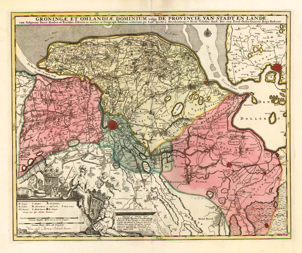
Groningae et Omlandiae Dominium vulgo de Provincie van Stadt en Lande. c. 1700
Groningen by N. Visscher II, published by Petrus Schenk.
[Item number: 25741]
Groninga. 1638
Groningen, by M. Merian.
[Item number: 25901]
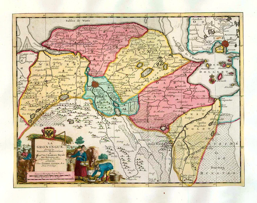
La Groningue. 1713
Groningen, by Pieter Van der Aa.
[Item number: 26057]