Amsterdam, by Georg Braun & Frans Hogenberg. 1618


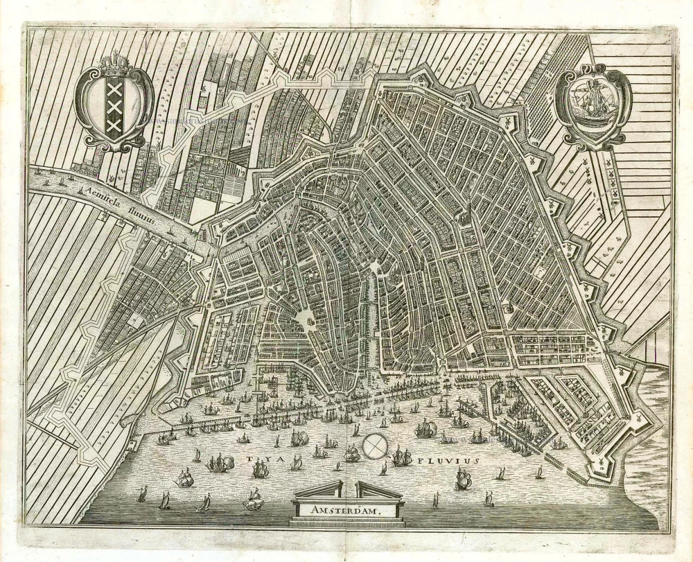
TRANSLATION OF CARTOUCHE TEXT LEFT: Amsterdam. Here the church buildings and the town hall, with the various parts of the city and fortifications and the surrounding canals all accurately drawn; and also the outlines of the New Town.
CARTOUCHE RIGHT: The dotted areas denote the Old Town; the remaining part is new.
COMMENTARY BY BRAUN: "When Amsterdam passed to the county it was impecunious, but it gradually increased in size and wealth to such an unbelievable extent that it has repeatedly, and for the last time very recently, been extended by more than half. [...] What inexpressible riches are heaped, as it were, on this city. One could say that Amsterdam wants for nothing, except that it has too much wealth. The city is like a store house from which not only neighbouring but also far distant countries are supplied in times of need, like Italy and Spain a few years ago. Here no one is excluded, but participation is open to anyone, of whatever nation or religion, who desires to carry on honest trade."
This city map oriented to the southwest is an update of the view of Amsterdam dating from 1572 shown in Volume I of the Civitates. It became necessary because of the drastic changes that had taken place since then. In the course of the city's rapid increase in prosperity, resulting not least from the East Indian trade, it was also considerably extended in size. The Oude Kerk, built before 1300 and converted into a basilica in the 16th century, can be made out, as can the fortifications of 1593, some of the most modern at the time, featuring 12 bastions. In addition, the map documents the extension of the city resolved in 1607, which began with the construction of fortifications in the west; these marked the new boundary of the city, and the planned continuation is indicated in outline. (Taschen)
Braun G. & Hogenberg F. and the Civitates Orbis Terrarum.
The Civitates Orbis Terrarum, or the "Braun & Hogenberg", is a six-volume town atlas and the most excellent book of town views and plans ever published: 363 engravings, sometimes beautifully coloured. It was one of the best-selling works in the last quarter of the 16th century. Georg Braun wrote the text accompanying the plans and views on the verso. Many plates were engraved after the original drawings of a professional artist, a professional artist, Joris Hoefnagel (1542-1600). The first volume was published in Latin in 1572, and the sixth in 1617. Frans Hogenberg created the tables for volumes I through IV, and Simon van den Neuwel made those for volumes V and VI. Other contributors were cartographers Daniel Freese and Heinrich Rantzau. Works by Jacob van Deventer, Sebastian Münster, and Johannes Stumpf were also used. Translations appeared in German and French.
Following the original publication of Volume 1 of the Civitates in 1572, seven further editions of 1575, 1577, 1582, 1588, 1593, 1599 and 1612 can be identified. Vol.2, first issued in 1575, was followed by further editions in 1597 and 1612. The subsequent volumes appeared in 1581, 1588, 1593, 1599 and 1606. The German translation of the first volume appeared from 1574 on, and the French edition from 1575 on.
Several printers were involved: Theodor Graminaeus, Heinrich von Aich, Gottfried von Kempen, Johannis Sinniger, Bertram Buchholtz and Peter von Brachel, who all worked in Cologne.
Georg Braun (1541-1622)
Georg Braun was born in Cologne in 1541. After his studies in Cologne, he entered the Jesuit Order as a novice. 1561, he obtained his bachelor's degree, and in 1562, he received his Magister Artium. Although he left the Jesuit Order, he studied theology, gaining a licentiate in theology.
Frans Hogenberg (1535-1590)
Frans Hogenberg was a Flemish and German painter, engraver, and mapmaker. He was born in Mechelen as the son of Nicolaas Hogenberg.
By the end of the 1560s, Frans Hogenberg was employed upon Abraham Ortelius's Theatrum Orbis Terrarum, published in 1570; he is named an engraver of numerous maps. In 1568, he was banned from Antwerp by the Duke of Alva and travelled to London, where he stayed a few years before emigrating to Cologne. He immediately embarked on his two most important works, the Civitates, published in 1572 and the Geschichtsblätter, which appeared in several series from 1569 until about 1587.
Thanks to large-scale projects like the Geschichtsblätter and the Civitates, Hogenberg's social circumstances improved with each passing year. He died as a wealthy man in Cologne in 1590.
Amstelodamum In quo cedes Sacrae, Curia Hospitalia, cum vicis et Burchvallis omniumquae interfluentiumalueis, accurate omnia delineantur, . . .
Item Number: 26769 Authenticity Guarantee
Category: Antique maps > Europe > The Netherlands - Cities
Old antique map - bird's-eye view plan of Amsterdam, by Georg Braun and Frans Hogenberg.
Oud, antiek plan in vogelperspectief van Amsterdam, door Georg Braun en Frans Hogenberg.
TRANSLATION OF CARTOUCHE TEXT LEFT: Amsterdam. Here the church buildings and the town hall, with the various parts of the city and fortifications and the surrounding canals all accurately drawn; and also the outlines of the New Town.
CARTOUCHE RIGHT: The dotted areas denote the Old Town; the remaining part is new.
COMMENTARY BY BRAUN: "When Amsterdam passed to the county it was impecunious, but it gradually increased in size and wealth to such an unbelievable extent that it has repeatedly, and for the last time very recently, been extended by more than half. [...] What inexpressible riches are heaped, as it were, on this city. One could say that Amsterdam wants for nothing, except that it has too much wealth. The city is like a store house from which not only neighbouring but also far distant countries are supplied in times of need, like Italy and Spain a few years ago. Here no one is excluded, but participation is open to anyone, of whatever nation or religion, who desires to carry on honest trade."
This city map oriented to the southwest is an update of the view of Amsterdam dating from 1572 shown in Volume I of the Civitates. It became necessary because of the drastic changes that had taken place since then. In the course of the city's rapid increase in prosperity, resulting not least from the East Indian trade, it was also considerably extended in size. The Oude Kerk, built before 1300 and converted into a basilica in the 16th century, can be made out, as can the fortifications of 1593, some of the most modern at the time, featuring 12 bastions. In addition, the map documents the extension of the city resolved in 1607, which began with the construction of fortifications in the west; these marked the new boundary of the city, and the planned continuation is indicated in outline. (Taschen)
Date of the first edition: 1617
Date of this map: 1618
Copper engraving, printed on paper.
Size (not including margins): 27.5 x 38.5cm (10.7 x 15 inches)
Verso text: German
Condition: Original coloured, excellent.
Condition Rating: A+
References: Van der Krogt 4, #108; Taschen, Br. Hog., p.447, Fauser #367; DAilly, #97.
From: Contrafactur und Beschreibung von den vornembsten Stätten der gantzen Welt, das sechste Buch, 1618. Getruckt zu Cölln, Bey Anthoni Hierath, und Abraham Hogenberg. Im Jahr 1618. (Van der Krogt, 41:2.6)
TRANSLATION OF CARTOUCHE TEXT LEFT: Amsterdam. Here the church buildings and the town hall, with the various parts of the city and fortifications and the surrounding canals all accurately drawn; and also the outlines of the New Town.
CARTOUCHE RIGHT: The dotted areas denote the Old Town; the remaining part is new.
COMMENTARY BY BRAUN: "When Amsterdam passed to the county it was impecunious, but it gradually increased in size and wealth to such an unbelievable extent that it has repeatedly, and for the last time very recently, been extended by more than half. [...] What inexpressible riches are heaped, as it were, on this city. One could say that Amsterdam wants for nothing, except that it has too much wealth. The city is like a store house from which not only neighbouring but also far distant countries are supplied in times of need, like Italy and Spain a few years ago. Here no one is excluded, but participation is open to anyone, of whatever nation or religion, who desires to carry on honest trade."
This city map oriented to the southwest is an update of the view of Amsterdam dating from 1572 shown in Volume I of the Civitates. It became necessary because of the drastic changes that had taken place since then. In the course of the city's rapid increase in prosperity, resulting not least from the East Indian trade, it was also considerably extended in size. The Oude Kerk, built before 1300 and converted into a basilica in the 16th century, can be made out, as can the fortifications of 1593, some of the most modern at the time, featuring 12 bastions. In addition, the map documents the extension of the city resolved in 1607, which began with the construction of fortifications in the west; these marked the new boundary of the city, and the planned continuation is indicated in outline. (Taschen)
Braun G. & Hogenberg F. and the Civitates Orbis Terrarum.
The Civitates Orbis Terrarum, or the "Braun & Hogenberg", is a six-volume town atlas and the most excellent book of town views and plans ever published: 363 engravings, sometimes beautifully coloured. It was one of the best-selling works in the last quarter of the 16th century. Georg Braun wrote the text accompanying the plans and views on the verso. Many plates were engraved after the original drawings of a professional artist, a professional artist, Joris Hoefnagel (1542-1600). The first volume was published in Latin in 1572, and the sixth in 1617. Frans Hogenberg created the tables for volumes I through IV, and Simon van den Neuwel made those for volumes V and VI. Other contributors were cartographers Daniel Freese and Heinrich Rantzau. Works by Jacob van Deventer, Sebastian Münster, and Johannes Stumpf were also used. Translations appeared in German and French.
Following the original publication of Volume 1 of the Civitates in 1572, seven further editions of 1575, 1577, 1582, 1588, 1593, 1599 and 1612 can be identified. Vol.2, first issued in 1575, was followed by further editions in 1597 and 1612. The subsequent volumes appeared in 1581, 1588, 1593, 1599 and 1606. The German translation of the first volume appeared from 1574 on, and the French edition from 1575 on.
Several printers were involved: Theodor Graminaeus, Heinrich von Aich, Gottfried von Kempen, Johannis Sinniger, Bertram Buchholtz and Peter von Brachel, who all worked in Cologne.
Georg Braun (1541-1622)
Georg Braun was born in Cologne in 1541. After his studies in Cologne, he entered the Jesuit Order as a novice. 1561, he obtained his bachelor's degree, and in 1562, he received his Magister Artium. Although he left the Jesuit Order, he studied theology, gaining a licentiate in theology.
Frans Hogenberg (1535-1590)
Frans Hogenberg was a Flemish and German painter, engraver, and mapmaker. He was born in Mechelen as the son of Nicolaas Hogenberg.
By the end of the 1560s, Frans Hogenberg was employed upon Abraham Ortelius's Theatrum Orbis Terrarum, published in 1570; he is named an engraver of numerous maps. In 1568, he was banned from Antwerp by the Duke of Alva and travelled to London, where he stayed a few years before emigrating to Cologne. He immediately embarked on his two most important works, the Civitates, published in 1572 and the Geschichtsblätter, which appeared in several series from 1569 until about 1587.
Thanks to large-scale projects like the Geschichtsblätter and the Civitates, Hogenberg's social circumstances improved with each passing year. He died as a wealthy man in Cologne in 1590.