
Finland and Estonia by Guillaume Sanson. 1703
SANSON FAMILY
Nicolas Sanson (1600-1667) - Guillaume Sanson (1633-1703) - Pierre Moullart-Sanson (? -1730)
Originally from Abbeville, Nicolas I Sanson showed a keen interest in historical geography. He was still very young; he published a map of ancient Gaul and two treatises, Britannia and Portus Itius on Abbeville and Boulogne's origins. His meeting with Melchior Tavernier was decisive: it prompted him to give up his duties as a military engineer in Picardy and devote himself to engraved cartography.
At the same time, Sanson had drawn up the outline of modern France. He got the help of Tavernier, who encouraged him to compete with the Dutch map publishers. Tavernier contacted other French cartographers whose works he published.
From 1643, N. Sanson obtained a privilege to publish a work personally, the Princes souverains de l'Italie. Then, in 1644 and 1645, he had his famous geographical tables printed, which significantly contributed to his fame. He also published a series of atlases in quarto of the four continents.
In 1648, N. Sanson associated himself with Mariette to publish atlases. From then on, specific maps bore his name and others Mariette's. N. Sanson and Mariette worked together for more than 20 years. After the death of N. Sanson, Mariette acquired the entire fund. Since Mariette only wanted to publish complete atlases, individual maps were no longer sold, and some army generals complained to the king.
The disagreement between the Sanson family and Pierre II Mariette culminated in 1671 when Guillaume Sanson took the case to court. There was no longer any question of collaboration: Guillaume Sanson started working for another publisher, Alexis-Hubert Jaillot.
The Sanson family faced financial difficulties, and in 1692, their cousin, Pierre Moullart-Sanson, bought the entire geographic fund from his uncles and aunt. Pierre Moullart-Sanson was the son of Françoise Sanson (third child of Nicolas) and Pierre Moullart. He restarted the publishing of Sanson's world atlas, and in 1704 he acquired a privilege for publishing all the works of Nicolas and Guillaume Sanson, which continued to be published until 1730.
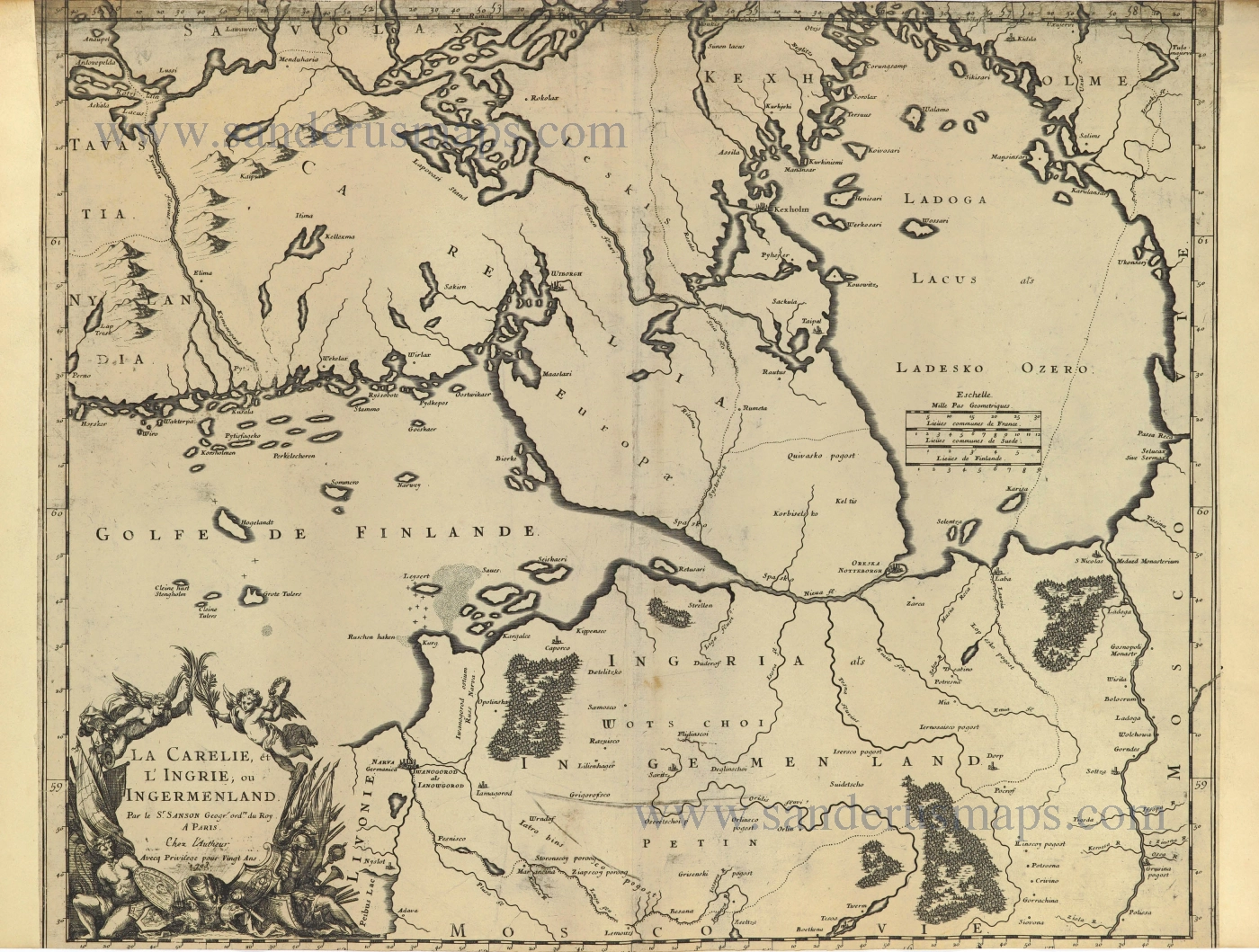
La Carelie, et l'Ingrie, ou Ingermenland.
Item Number: 28500 Authenticity Guarantee
Category: Antique maps > Europe > Northern Europe
Old, antique map of Finland - Estonia, by Guillaume Sanson.
Title: La Carelie, et l'Ingrie, ou Ingermenland.
Par le Sr. Sanson Geogr. Ord.re du Roy.
A Paris Chez l'Autheur
Avecq Privilege pour Vingt Ans. 1703.
Date of the first edition: 1666.
Date of this map: 1703.
Date on map: 1703.
Copper engraving, printed on paper.
Map size: 445 x 550mm (17.52 x 21.65 inches).
Sheet size: 445 x 605mm (17.52 x 23.82 inches).
Verso: Blank.
Condition: Backed with paper, upper and lower margins trimmed.
Condition Rating: B.
References: Pastoureau, See Sanson V D p. 413 [189]
From: Cartes et Tables de la Geographie Ancienne et Nouvelle ou Methode pour s'Instruire Avec facilite de la Geographie, et Connoistre des Empires, Monarchies, Royaumes, Estats, Republiques, et Peuples ... Par les Srs. Sanson, Geographes du Roy ... A Paris. Chez l'Autheur ... 1697. (With maps dated until 1709). See David Rumsey Map Collection.
SANSON FAMILY
Nicolas Sanson (1600-1667) - Guillaume Sanson (1633-1703) - Pierre Moullart-Sanson (? -1730)
Originally from Abbeville, Nicolas I Sanson showed a keen interest in historical geography. He was still very young; he published a map of ancient Gaul and two treatises, Britannia and Portus Itius on Abbeville and Boulogne's origins. His meeting with Melchior Tavernier was decisive: it prompted him to give up his duties as a military engineer in Picardy and devote himself to engraved cartography.
At the same time, Sanson had drawn up the outline of modern France. He got the help of Tavernier, who encouraged him to compete with the Dutch map publishers. Tavernier contacted other French cartographers whose works he published.
From 1643, N. Sanson obtained a privilege to publish a work personally, the Princes souverains de l'Italie. Then, in 1644 and 1645, he had his famous geographical tables printed, which significantly contributed to his fame. He also published a series of atlases in quarto of the four continents.
In 1648, N. Sanson associated himself with Mariette to publish atlases. From then on, specific maps bore his name and others Mariette's. N. Sanson and Mariette worked together for more than 20 years. After the death of N. Sanson, Mariette acquired the entire fund. Since Mariette only wanted to publish complete atlases, individual maps were no longer sold, and some army generals complained to the king.
The disagreement between the Sanson family and Pierre II Mariette culminated in 1671 when Guillaume Sanson took the case to court. There was no longer any question of collaboration: Guillaume Sanson started working for another publisher, Alexis-Hubert Jaillot.
The Sanson family faced financial difficulties, and in 1692, their cousin, Pierre Moullart-Sanson, bought the entire geographic fund from his uncles and aunt. Pierre Moullart-Sanson was the son of Françoise Sanson (third child of Nicolas) and Pierre Moullart. He restarted the publishing of Sanson's world atlas, and in 1704 he acquired a privilege for publishing all the works of Nicolas and Guillaume Sanson, which continued to be published until 1730.
Related items
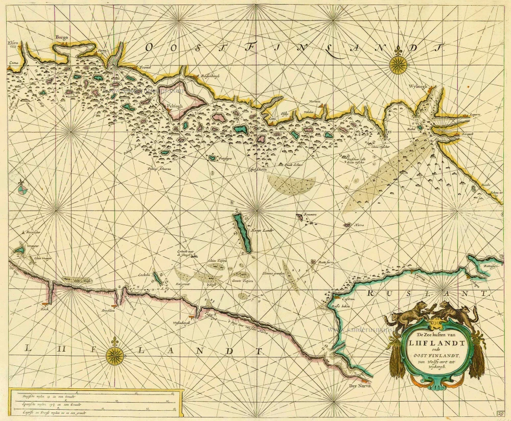
De Zee kusten van Liiflandt ende Oost Finlandt, van Wolfs-oort tot Wyborgh. 1686
Gulf of Finland, by Doncker H.
[Item number: 14610]
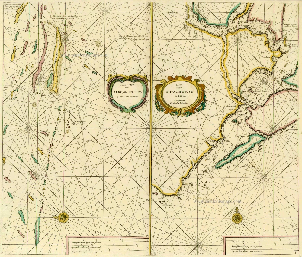
Caarte van 't gat van Abbo, ofte Uttoy. [on sheet with] Caarte van 't Stochomse Liet. 1686
Sea chart of Finland - Sweden, by Doncker H.
[Item number: 14593]
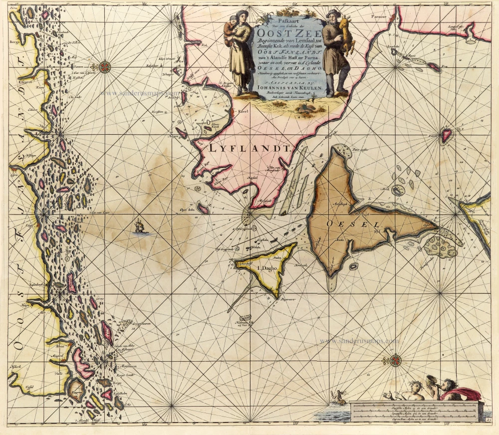
Paskaart voor een Gedeelte der Oost Zee Beginnende van Lemsaal, tot Beooste Kok als mede de Kust van Oost Finlandt. Van 't Alandse Haff, tot Parna, waar in ook vervat is, d' Eylande Oesel, en Dagho. 1697-1709
Finland - Estonia, by J. Van Keulen.
[Item number: 25288]
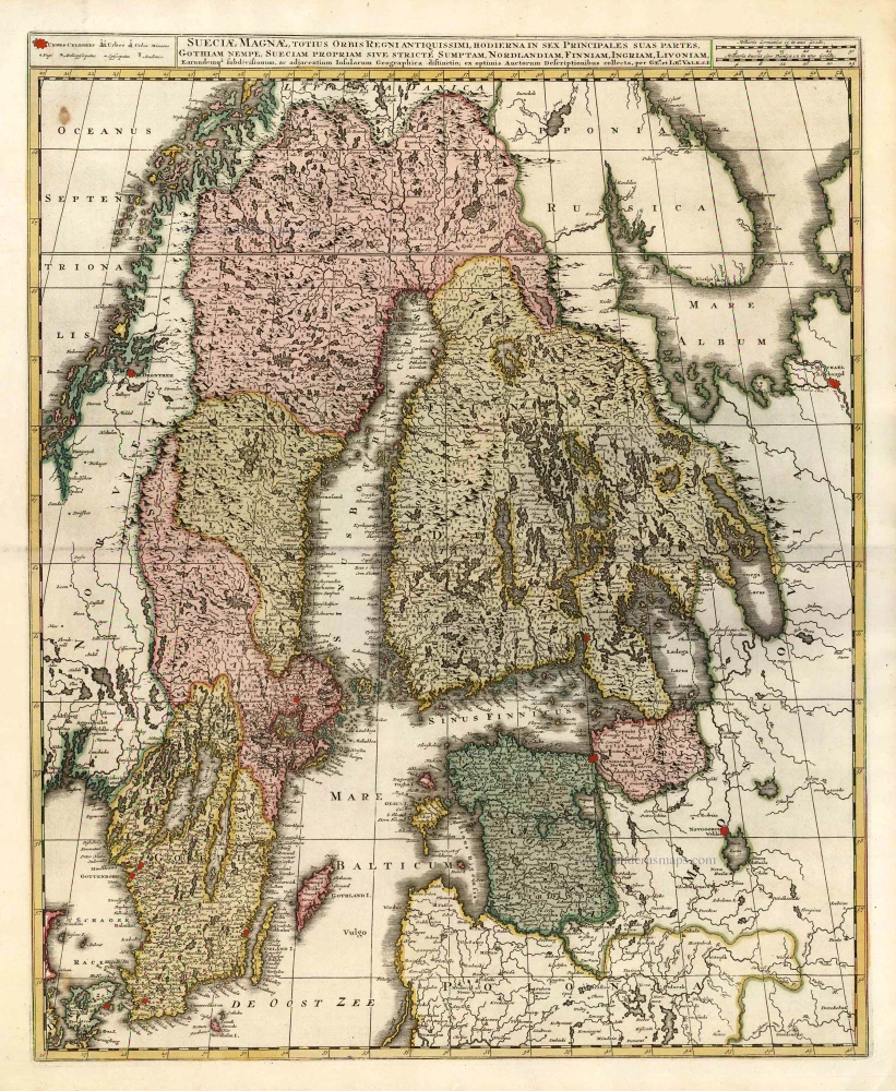
Sueciae Magnae, totius Orbis Regniantiquissimi, hodierna in sex Principales suas partes, Gothiam nempe, Sueciam propriam sive stricté Sumptam, Nordlandiam, Finniam, Ingriam, Livoniam, ... c. 1745
Finland, Sweden, Latvia, by Valk G. & L. - Ottens R. & I.
[Item number: 25846]

Regni Sueciae Tabula Generalis, divisa in Sueciae, Gotiae Regna Finniae Ducatum Lapponiam, Livoniam Nordlandiam Ingriam et in omnes subiacentes provincias. c. 1715
Finland & Sweden by Frederik de Wit, published by Covens & Mortier.
[Item number: 28267]
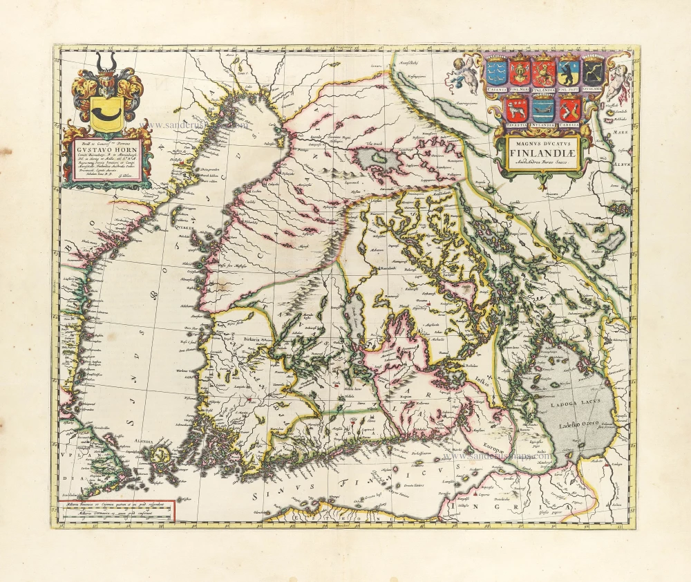
First printed map of Finland.
Magnus Ducatus Finlandiae. 1659
Finland by Joan Blaeu.
[Item number: 30242]