
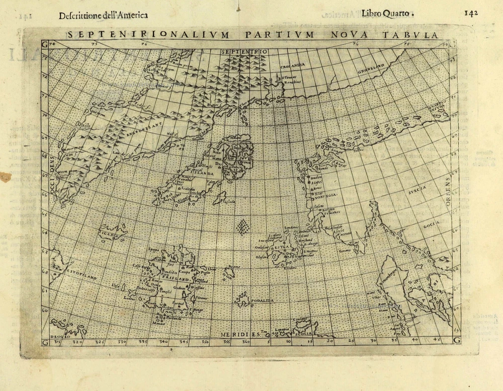
Northern Atlantic Ocean by Girolamo Ruscelli. 1574
Girolamo Ruscelli (1504 (1518?) -1566)
Girolamo Ruscelli was an Italian mathematician and cartographer active in Venice during the early 16th century. He was also an alchemist, writing pseudonymously as Alessio Piemontese.
He published a translation of the Geografia of Ptolemy, printed in Venice by Vincenzo Valgrisi in 1561. It was a quarto edition with Ptolemaic and modern maps. The engravers may have been the brothers Giulio and Livio Sanuto. Among the 69 copperplate maps were 40 based on maps by Giacomo Gastaldi. The maps were re-issued in 1562, 1564, 1574 and 1598.
Septenirionalium Partium Nova Tabula.
Item Number: 28298 Authenticity Guarantee
Category: Antique maps > Europe > Northern Europe
Old, antique map of Atlantic Ocean (North), by Girolamo Ruscelli.
Title: Septenirionalium Partium Nova Tabula.
Cartographer: Nicolo Zeno.
Second edition with the word 'Septenirionalium' in the title. (In the first edition 1561: Septentrionalium).
Date of the first edition: 1561.
Date of this map: 1574.
Copper engraving, printed on paper.
Size (not including margins): 190 x 245mm (7.48 x 9.65 inches).
Verso: Italian text.
Condition: Excellent.
Condition Rating: A+.
References: Burden, #45;
From: La Geografia di Claudio Tolomeo Alessandrino, Nuovamente tradotta di Greco in Italiano da Girolamo Ruscelli. Venice, Vincenzo Valgrisi, 1574. (Karrow, p. 222 30/C.1)
Girolamo Ruscelli (1504 (1518?) -1566)
Girolamo Ruscelli was an Italian mathematician and cartographer active in Venice during the early 16th century. He was also an alchemist, writing pseudonymously as Alessio Piemontese.
He published a translation of the Geografia of Ptolemy, printed in Venice by Vincenzo Valgrisi in 1561. It was a quarto edition with Ptolemaic and modern maps. The engravers may have been the brothers Giulio and Livio Sanuto. Among the 69 copperplate maps were 40 based on maps by Giacomo Gastaldi. The maps were re-issued in 1562, 1564, 1574 and 1598.
Related items
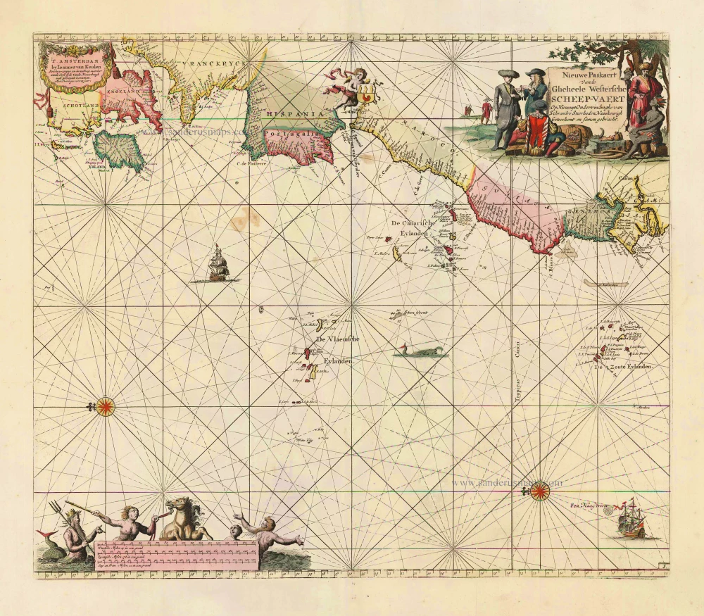
Nieuwe Paskaert vande Gheheele Westersche Scheep-Vaert, op Nieus uyt Ondervindinghe van Schrandre Stierlieden Naaukeurigh Geteeckent en Samen Gebracht. 1697-1709
The Atlantic Ocean, by J. Van Keulen.
[Item number: 11218]

Ocean Atlantique et Mers Adjacentes en Quatre Feuilles Contenant les Cotes de l'Europe, de l'Afrique et de l'Amerique ... 1778
The Atlantic Ocean, by G.L. Le Rouge.
[Item number: 14086]

The first sea chart relating to North America to use the Mercator projection
West-Indische Paskaert waer in de graden der breedde over wederzijden vande middellijn wassende so vergrooten dat die geproportioneert sijn tegen hunne nevenstaende graden der lengde; ... c. 1680
Atlantic Ocean. by P. Goos - J. Van Keulen
[Item number: 25938]
Rare.
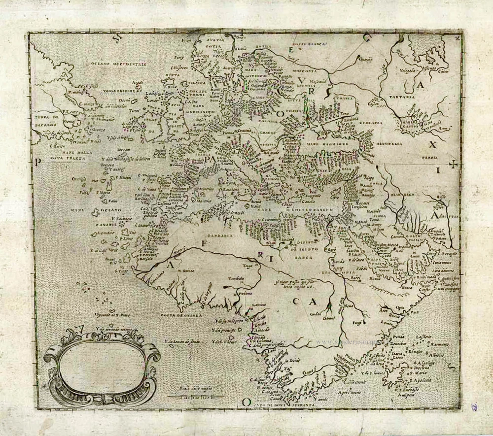
[No title] c. 1575
Atlantic Ocean - Europe, Africa & Eastern Canada by Giovanni Francesco Camocio
[Item number: 27086]
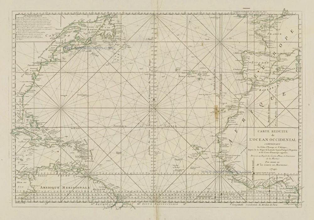
Carte Reduite de l'Ocean Occidental comprenant les Côtes d'Europe et d'Afrique, depuis le 52 Degré de Latitude Sept. jusqu'à l'Equateur et les Cotes d'Amerique opposées. 1756-1770
Atlantic Ocean, by J.N. Bellin.
[Item number: 28087]