
(East) - California by Doncker H. 1659


Hendrick Doncker (1625-1699)
Hendrick Doncker became a member of the bookseller's guild in 1647 and ran his shop successfully for fifty years. He was able to develop one of the most popular sets of maritime works published in Amsterdam during the Golden Age.
In 1651 he bought a house in the Nieuwe Brugsteeg in Amsterdam. It was called 'in 't Stuurmans gereetschap' (in the mariners' instruments) and stood opposite the house where Johannes van Keulen later settled.
Apart from the sea atlases, charts and pilot books, Hendrik Doncker published various editions of textbooks on the art of navigation.
After the death of Hendrick Doncker, the son, Hendrick II (c. 1664-c.1739), continued publishing the sea atlases Zeeatlas and Zeespiegel until 1708.
Doncker's charts were the most up-to-date in the second half of the 17th century. Although there is some similarity to those charts published by Van Loon, Goos, Lootsman, and Doncker, the latter's charts are original.
In 1655, Hendrick Doncker had begun with the publication of a pilot guide, the Lichtende Columne ofte Zeespiegel. In 1659 he published his first sea atlas, the Zee-Atlas of Waeter-waereld, with 19 maps. Between 1659 and 1669, he increased the number of charts from 19 to 30 and in 1669 he came with an edition containing 50, which was soon to be followed by an edition with large maps: the Nieuwe Groote Vermeerderde Zeeatlas, also with 50 charts. This beautiful atlas was reprinted and continually improved for more than 25 years. After the death of Hendrick Doncker in 1699, his son continued the publication and even enlarged and enhanced the sea-atlas.
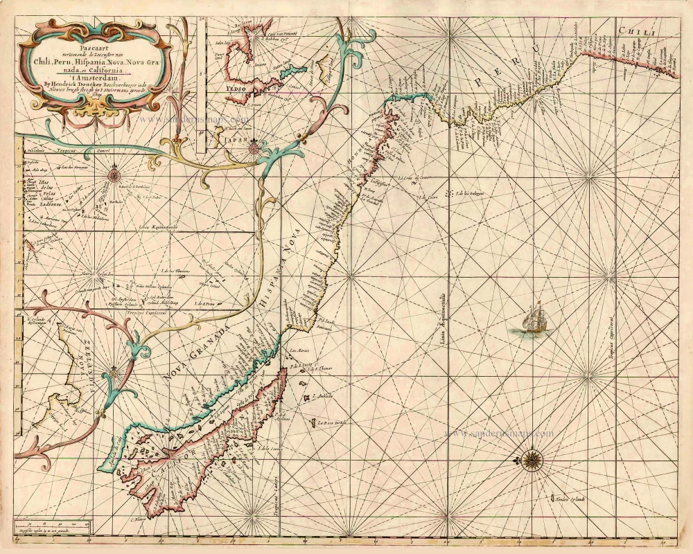
Pascaart Vertoonende de Zeecusten van Chili, Peru, Hispania Nova, Nova Granada, en California.
Item Number: 27522 Authenticity Guarantee
Category: Antique maps > Oceans
Old, antique map of the Pacific Ocean showing the west coast of North and South America, by Hendrick Doncker.
Rare first state without the eastern coastline of Central America.
Oriented to the east. It depicts California as an island on a larger scale than any earlier sea chart.
Three inset maps: The discoveries of Abel Jansz. Tasman in New Zealand; Maerten Gerritsz Vries' voyage in the Kuriles to the north of Japan and Islas de las Velas alias Ladrones.
Date of the first edition: 1659
Date of this map: 1659
Copper engraving, printed on paper.
Size (not including margins): 43 x 54cm (16.8 x 21.1 inches)
Verso: Blank
Condition: Original coloured, excellent.
Condition Rating: A+
References: Koeman, Don2 [21]; Burden, #340, State 1; McLaughlin, #21; Wagner, #382
From: De Zee-Atlas Ofte Water-Waereld, Vertoonende all de Zee-Kusten Van het bekende Deel des Aerd-Bodems, ... Amsterdam, 1659. (Koeman, Don1)
According to Koeman, there is no surviving example of this atlas known.
Hendrick Doncker (1625-1699)
Hendrick Doncker became a member of the bookseller's guild in 1647 and ran his shop successfully for fifty years. He was able to develop one of the most popular sets of maritime works published in Amsterdam during the Golden Age.
In 1651 he bought a house in the Nieuwe Brugsteeg in Amsterdam. It was called 'in 't Stuurmans gereetschap' (in the mariners' instruments) and stood opposite the house where Johannes van Keulen later settled.
Apart from the sea atlases, charts and pilot books, Hendrik Doncker published various editions of textbooks on the art of navigation.
After the death of Hendrick Doncker, the son, Hendrick II (c. 1664-c.1739), continued publishing the sea atlases Zeeatlas and Zeespiegel until 1708.
Doncker's charts were the most up-to-date in the second half of the 17th century. Although there is some similarity to those charts published by Van Loon, Goos, Lootsman, and Doncker, the latter's charts are original.
In 1655, Hendrick Doncker had begun with the publication of a pilot guide, the Lichtende Columne ofte Zeespiegel. In 1659 he published his first sea atlas, the Zee-Atlas of Waeter-waereld, with 19 maps. Between 1659 and 1669, he increased the number of charts from 19 to 30 and in 1669 he came with an edition containing 50, which was soon to be followed by an edition with large maps: the Nieuwe Groote Vermeerderde Zeeatlas, also with 50 charts. This beautiful atlas was reprinted and continually improved for more than 25 years. After the death of Hendrick Doncker in 1699, his son continued the publication and even enlarged and enhanced the sea-atlas.