
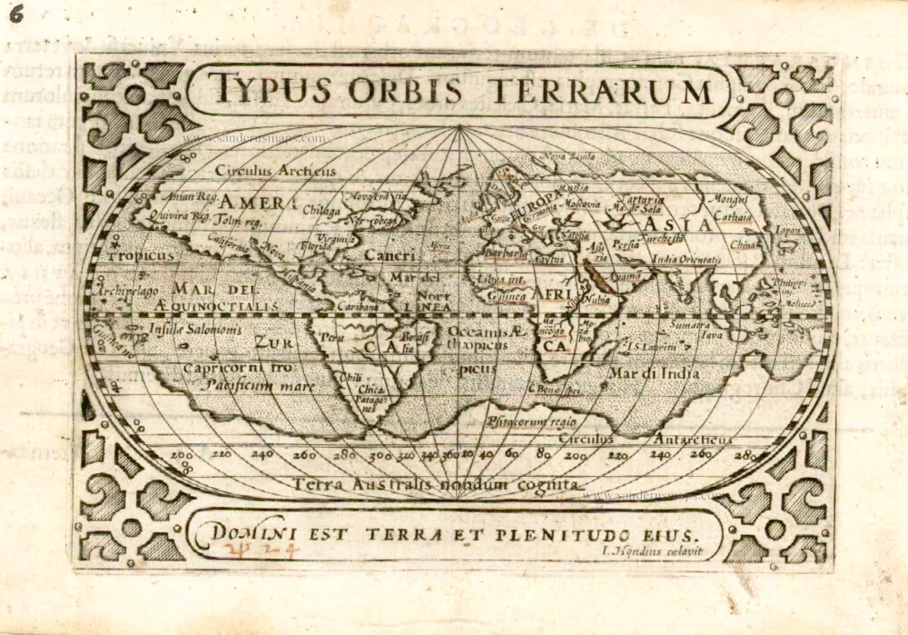
WORLD by Sebastian Münster 1550
The item displayed on this page has been sold. However, we have a similar map in stock:
Sebastian Münster, world map 1550
Typus Orbis Universalis.
[Item number: 29795]


Sebastian Münster (1488-1552), geographer, cartographer, Hebraist, and theologian, produced sixty-one double-page maps for use in various editions of Ptolemy's Geographia and in his own Cosmographia. Some of these maps appeared in all editions of both works, some only in certain editions. All were woodcut maps with the title supplied in letterpress in the upper margin; these titles varied from edition to edition.
Münster based his edition of Ptolemy on the Latin translation by Willibald Pirkheimer.
Claudius Ptolemy (c.100 – c.170 AD)
Claudius Ptolemaeus was a Greek astronomer, mathematician, and geographer who lived in Alexandria during the 2nd century. Much of medieval astronomy and geography were built on his ideas. He was the first to use longitudinal and latitudinal coordinates. This idea of a global coordinates system was highly influential, and we use a similar system today.
Ptolemy wrote several scientific treatises. The first is the astronomical treatise now known as the Almagest, and the second is the Geography, which is a thorough discussion of the geographic knowledge of the Greco-Roman world. The third is the Apotelesmatika, an astrological treatise in which he attempted to adapt horoscopic astrology to the Aristotelian natural philosophy of his day.
The Geographia is a compilation of geographical coordinates of the part of the world known to the Roman Empire during his time. However, the maps in surviving manuscripts of Ptolemy's Geography only date from about 1300, after Maximus Planudes rediscovered the text. It seems likely that the topographical tables are cumulative texts – texts which were altered and added to as new knowledge became available in the centuries after Ptolemy.
The earliest printed edition with engraved maps was produced in Bologna in 1477, followed quickly by a Roman edition in 1478. An edition printed at Ulm in 1482, including woodcut maps, was the first one published north of the Alps.
Sebastian Münster (1488-1552)
Sebastian Münster, a German geographer, cartographer, Hebraist, and theologian, was born in Ingelheim, near Mainz In 1505, he went to Heidelberg to enter the Franciscan order. In 1507 he went to Louvain, where he studied mathematics, geography, and astronomy. In 1509 Münster became a student of Konrad Pelikan, who taught Hebrew and Greek as well as mathematics and cosmography. In 1518 he completed his studies at the University of Tübingen. He was the favorite of the famous mathematician and astronomer Johann Stöffler.
In 1524 Münster was appointed professor of Hebrew at Heidelberg University. In 1525 he published his first map as part of a broadside: The Instrument of the Suns combined a map, calendar, astrological almanac, sundial, and nocturnal on one attractive sheet, suitable for wall mounting.
In 1540 he published a Latin edition of Ptolemy's Geographia with illustrations. He based this edition on the Latin translation by Willibald Pirkheimer and produced new maps to supplement the Ptolemaic maps. The twenty-seven maps of the Ptolemaic canon are supplemented by twenty-one new maps. Further editions appeared in 1541 and 1542.
In 1544 he published the Cosmographia, a bulky book with 659 pages and some 520 woodcuts. Maps in this edition included three maps from the Ptolemaic canon and fourteen modern maps (from previous editions of the Geographia), as well as nine new maps. Later editions (1545, 1546, 1548) enlarged the Cosmographia. The 1550 edition contains cities, portraits, and costumes. These editions in both Latin and German constitute the full fruition of Münster's dream of a comprehensive geography.
The Cosmographia was one of the most successful works of the 16th century. It passed through 24 editions in 100 years, in different languages, including Latin, French, Italian, English, and even Czech. The last German edition was published in 1628.
He died at Basel of the plague in 1552.
As a cartographer, Münster deserves special recognition for formulating a plan for a comprehensive and uniform map of a country. As a geographer, his greatest achievement was the Cosmographia. (Karrow).
Typus Orbis Universalis.
Item Number: 25766 Authenticity Guarantee
Category: Antique maps > World and Polar
Old, antique map of the World by Sebastian Münster.
Date of the first edition: 1550
Date of this map: 1550-1578.
Woodcut
Woodcutter: David Kandel (His initials 'DK' in the lower left-hand corner).
Size, not including title: 27 x 38cm (10.4 x 14.8 inches)
Verso text: Latin
Condition: Excellent.
Condition Rating: A
References: Shirley (World), 92; Karrow, 58/73.1; Clancy, p.63 Map.5.2.
From: Cosmographiae universalis Lib. VI. . . . Basle, 1550.
Sebastian Münster (1488-1552), geographer, cartographer, Hebraist, and theologian, produced sixty-one double-page maps for use in various editions of Ptolemy's Geographia and in his own Cosmographia. Some of these maps appeared in all editions of both works, some only in certain editions. All were woodcut maps with the title supplied in letterpress in the upper margin; these titles varied from edition to edition.
Münster based his edition of Ptolemy on the Latin translation by Willibald Pirkheimer.
Claudius Ptolemy (c.100 – c.170 AD)
Claudius Ptolemaeus was a Greek astronomer, mathematician, and geographer who lived in Alexandria during the 2nd century. Much of medieval astronomy and geography were built on his ideas. He was the first to use longitudinal and latitudinal coordinates. This idea of a global coordinates system was highly influential, and we use a similar system today.
Ptolemy wrote several scientific treatises. The first is the astronomical treatise now known as the Almagest, and the second is the Geography, which is a thorough discussion of the geographic knowledge of the Greco-Roman world. The third is the Apotelesmatika, an astrological treatise in which he attempted to adapt horoscopic astrology to the Aristotelian natural philosophy of his day.
The Geographia is a compilation of geographical coordinates of the part of the world known to the Roman Empire during his time. However, the maps in surviving manuscripts of Ptolemy's Geography only date from about 1300, after Maximus Planudes rediscovered the text. It seems likely that the topographical tables are cumulative texts – texts which were altered and added to as new knowledge became available in the centuries after Ptolemy.
The earliest printed edition with engraved maps was produced in Bologna in 1477, followed quickly by a Roman edition in 1478. An edition printed at Ulm in 1482, including woodcut maps, was the first one published north of the Alps.
Sebastian Münster (1488-1552)
Sebastian Münster, a German geographer, cartographer, Hebraist, and theologian, was born in Ingelheim, near Mainz In 1505, he went to Heidelberg to enter the Franciscan order. In 1507 he went to Louvain, where he studied mathematics, geography, and astronomy. In 1509 Münster became a student of Konrad Pelikan, who taught Hebrew and Greek as well as mathematics and cosmography. In 1518 he completed his studies at the University of Tübingen. He was the favorite of the famous mathematician and astronomer Johann Stöffler.
In 1524 Münster was appointed professor of Hebrew at Heidelberg University. In 1525 he published his first map as part of a broadside: The Instrument of the Suns combined a map, calendar, astrological almanac, sundial, and nocturnal on one attractive sheet, suitable for wall mounting.
In 1540 he published a Latin edition of Ptolemy's Geographia with illustrations. He based this edition on the Latin translation by Willibald Pirkheimer and produced new maps to supplement the Ptolemaic maps. The twenty-seven maps of the Ptolemaic canon are supplemented by twenty-one new maps. Further editions appeared in 1541 and 1542.
In 1544 he published the Cosmographia, a bulky book with 659 pages and some 520 woodcuts. Maps in this edition included three maps from the Ptolemaic canon and fourteen modern maps (from previous editions of the Geographia), as well as nine new maps. Later editions (1545, 1546, 1548) enlarged the Cosmographia. The 1550 edition contains cities, portraits, and costumes. These editions in both Latin and German constitute the full fruition of Münster's dream of a comprehensive geography.
The Cosmographia was one of the most successful works of the 16th century. It passed through 24 editions in 100 years, in different languages, including Latin, French, Italian, English, and even Czech. The last German edition was published in 1628.
He died at Basel of the plague in 1552.
As a cartographer, Münster deserves special recognition for formulating a plan for a comprehensive and uniform map of a country. As a geographer, his greatest achievement was the Cosmographia. (Karrow).
Related items
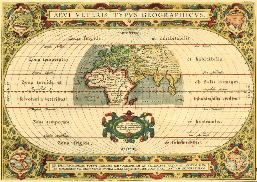
Aevi Veteris, Typus Geographicus 1595
Old, antique map of Ancient World by Ortelius A.
[Item number: 6684]
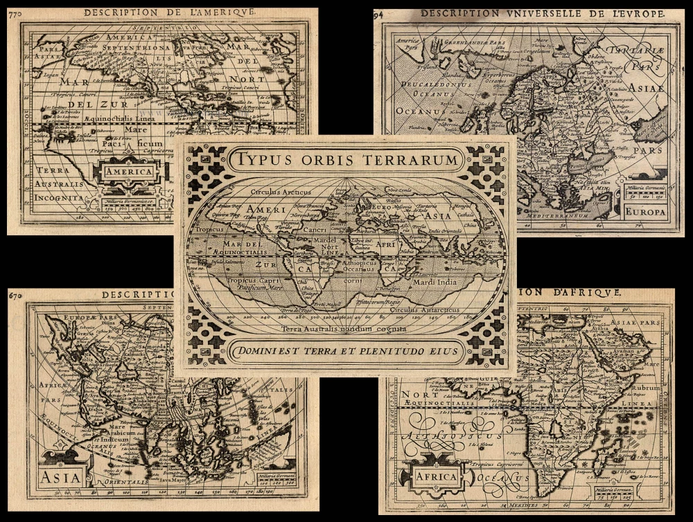
Typus Orbis Terrarum + Europa + Asia + Africa + America 1618
The World and Continents by Bertius P.
[Item number: 18172]
Superb condition
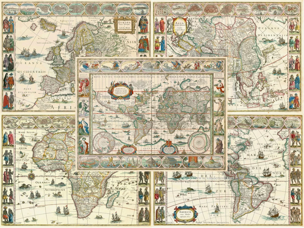
Nova Totius Terrarum Orbis Geographica ac Hydrographica. 1643-50
Willem Blaeu, set of 5 maps: World & continents.
[Item number: 24287]

Orbis Vetus in utraque Continente juxta Mentem Sansonianam Distinctus, nec non Observationibus Astronomicis Redactus ... c. 1757
The world by Robert de Vaugondy.
[Item number: 5092]
Typus Orbis Terrarum. 1602
World by Barent Langenes
[Item number: 12009]
One of the first double hemisphere world maps.
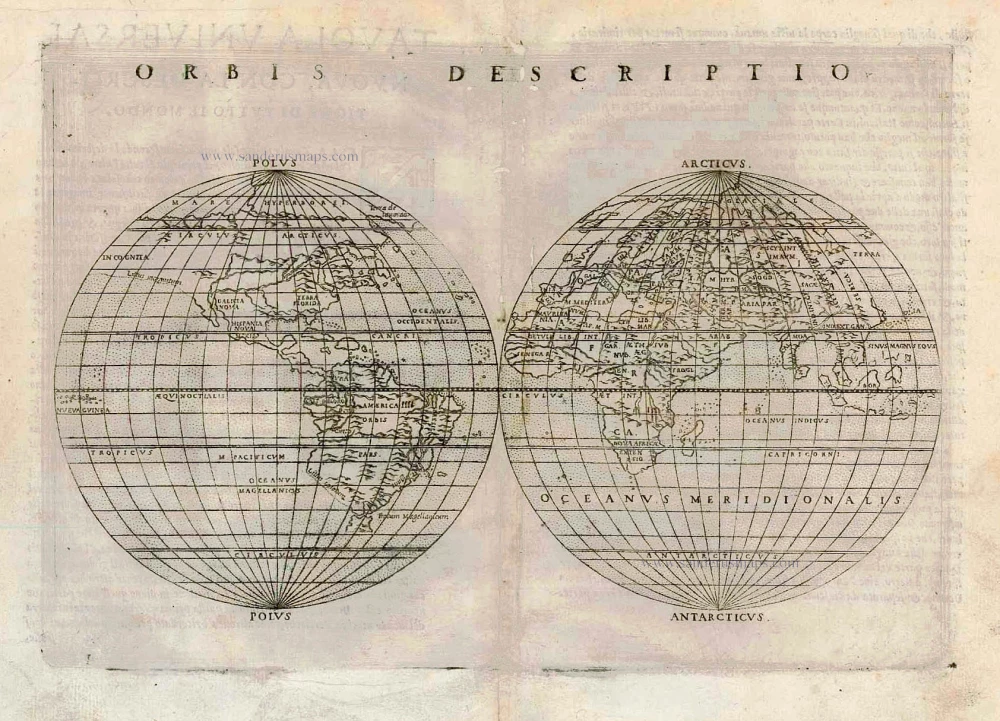
Orbis Descriptio. 1564
World by Girolamo Ruscelli.
[Item number: 27838]