
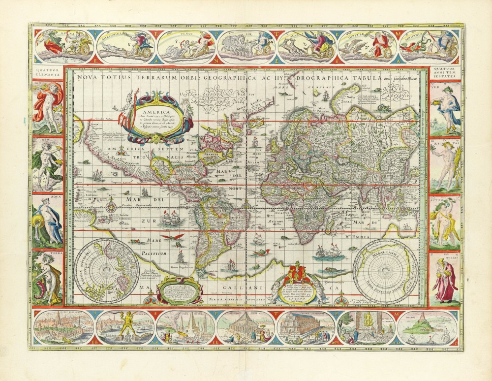
World in Mercator projection, by Willem Blaeu. 1634
The item displayed on this page has been sold. However, we have a similar map in stock:
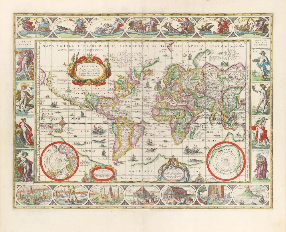
World in Mercator projection, by Willem Blaeu. 1643
Nova Totius Terrarum Orbis Geographica ac ...
[Item number: 30271]


While Blaeu was in the process of publishing his four-sheet wall map of the world on Mercator's projection, a world map in folio size using the same projection was issued by his publishing house. For many years, this map remained in atlases published by the Blaeu family, in spite of the increasing geographical knowledge then available (only the discovery of the Strait of Le Maire was added to later states). Apparently, purchasers preferred a decorative map of the world to a map that provided up-to-date geographical knowledge. Eventually Joan Blaeu, in his Atlas Maior (1662-64), replaced the world map made by his father with a new map.
The title in capitals runs along the upper edge within the map image. Because of the projection chosen, the areas north and south of the 50th degree of latitude are drawn in two hemispheres in the lower corners.
The map's dedication to the wealthy Amsterdam merchant and administrator Cornelis Pietersz Hooft (1547-1626) is now signed: Guilj. Blaeuw (in the first state, it was signed Gul. Iansonius 1606 = the old name of Willem Blaeu). The original 1606 state does not mention an engraver, but from the second state onward the name of Josua van den Ende appears on the map. It is probable that Van den Ende engraved only the geographic content, while someone else was responsible for the decoration. The geographic content is identical to that of the 1606/07 wall map. Because of the smaller size of the folio map, fewer toponyms are given and the number of legends has also been reduced. The centre of North America is taken up by a large oval cartouche containing a Latin text, here in translation: 'America. First discovered in A.D. 1492 by Christopher Colombus in the name of the king of Castille and given the name by Amerigo Vespucci in 1499'. The following legend, here in translation, is inserted in the area to the east of Novaya Zemlya: 'Novaya Zemlya. Discovered in 1596 by Willem Barentszoon from Amsterdam in the name of the States General of the Netherlands'.
Blaeu's world map is framed on all sides by decorative borders. Along the top are allegorical representations of the sun, moon and the five known planets: Mercury, Venus, Mars, Jupiter and Saturn. On the left the four elements, and on the right the four seasons. Along the bottom are seven vignettes showing the seven wonders of the world.
The decorative borders of the world map were not derived from artists' designs specially ordered by the publisher. On the contrary, Blaeu had a compilation made from various series of prints which had already been published by famous Dutch artists at the end of the sixteenth century.
A balanced composition and elegant ornamentation make this world map one of the small masterpieces of the seventeenth century.
The first state (1606) bears the name Gulielmus Ianssonius. The second state has the signature of the engraver Josua Van den Ende. The third state is with the Strait of Le Maire added (1618) and the fourth state is with the name of the publisher changed to 'Blaeuw'. The fourth state was included in Blaeu's 1630 Appendix and in all of the Blaeu family's atlases, except the Atlas maior.
The Blaeus: Willem Janszoon, Cornelis & Joan
Willem Jansz. Blaeu and his son Joan Blaeu are the seventeenth century's most widely known cartographic publishers.
Willem Jansz. (also written Guilielmus Janssonius) = Willem Janszoon Blaeu was born in Uitgeest (Netherlands), near Alkmaar, in 1571. He studied mathematics under Tycho Brahe and learned the theory and practice of astronomical observations and the art of instrument- and globe-making.
In 1596, he came to Amsterdam, where he settled down as a globe-, instrument- and map-maker. He published his first cartographic work (a globe) in 1599 and probably published his first printed map (a map of the Netherlands) in 1604. He specialised in maritime cartography, published the first edition of the pilot guide Het Licht der Zeevaert in 1608, and was appointed Hydrographer of the V.O.C. (United East India Company) in 1633. After publishing books, wall maps, globes, charts and pilot guides for thirty years, he brought out his first atlas, Atlas Appendix (1630). This was the beginning of the great tradition of atlas-making by the Blaeus.
In 1618, another mapmaker, bookseller and publisher, Johannes Janssonius, established himself in Amsterdam next door to Blaeu's shop. No wonder these two neighbours began accusing each other of copying and stealing their information and became fierce competitors who did not have a good word to say about each other. In about 1621 Willem Jansz. decided to end the confusion between his name and his competitor's and assumed his grandfather's nickname, 'blauwe Willem' ('blue Willem'), as the family name; after that, he called himself Willem Jansz. Blaeu.
Willem Janszoon Blaeu died in 1638, leaving his prospering business to his sons, Cornelis and Joan. We only know that Cornelis's name occurs in the prefaces of books and atlases until c. 1645.
Joan Blaeu, born in Amsterdam in 1596, became a partner in his father’s book trade and printing business. 1638, he was appointed his father’s successor in the Hydrographic Office of the V.O.C. His efforts culminated in the magnificent Atlas Major and the town books of the Netherlands and Italy – works unsurpassed in history and modern times, giving eternal fame to the name of the Blaeu's.
On February 23, 1672, a fire ruined the business. One year later, Dr Joan Blaeu died. The fire of 1672 and the passing away of the director gave rise to a complete sale of the stock of the Blaeu House. Five public auctions dispersed the remaining books, atlases, copperplates, globes, etc., among many other map dealers and publishers in Amsterdam. The majority was acquired by several booksellers acting in partnership.
In the succeeding years, the remaining printing department was left in the hands of the Blaeu family until 1695, when the printing house's inventory was sold at a public auction. That meant the end of the Blaeu's as a printing house of world renown.
Nova Totius Terrarum Orbis Geographica ac Hydrographica Tabula.
Item Number: 28137 Authenticity Guarantee
Category: Antique maps > World and Polar
Old, antique map of the World in Mercator projection, by Willem Blaeu.
Title: Nova Totius Terrarum Orbis Geographica ac Hydrographica Tabula.
auct: Guiljelmo Blaeuw; Ja. Van den Ende sculpsit.
Excudebat Gulielmus Blaeuw | Amsterodami sub signo Solarii deaurati.
Dedicated to Cornelis Petri F. Hooft by Guilj. Blaeuw.
Engraver: J. vanden Ende.
Date of the first edition: 1606 (first state).
Date of first atlas edition: 1630
Date of this map: 1634.
Copper engraving, printed on paper.
Size (not including margins): 410 x 540mm (16.14 x 21.26 inches).
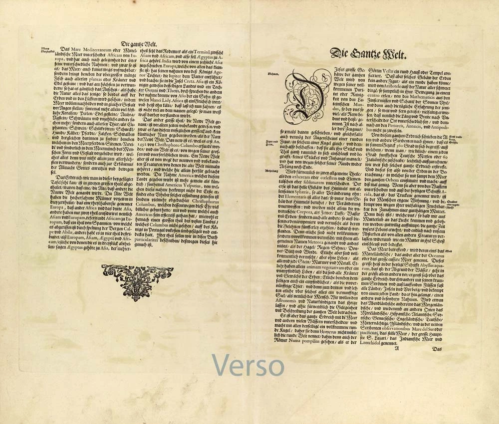
Verso: German text.
Condition: Superb original colouring, excellent.
Condition Rating: A+.
References: Shirley (World), 255 State 4; Schilder 4, 10.4 & Schilder 6, 1.4; Van der Krogt 2, 0001:2A; Baynton-Williams New Worlds, p.59.
From: Novus Atlas, Das ist Abbildung und Beschreibung von allen Ländern des Erdreichs. Amsterdam, 1634. (Van der Krogt 2, 131)
While Blaeu was in the process of publishing his four-sheet wall map of the world on Mercator's projection, a world map in folio size using the same projection was issued by his publishing house. For many years, this map remained in atlases published by the Blaeu family, in spite of the increasing geographical knowledge then available (only the discovery of the Strait of Le Maire was added to later states). Apparently, purchasers preferred a decorative map of the world to a map that provided up-to-date geographical knowledge. Eventually Joan Blaeu, in his Atlas Maior (1662-64), replaced the world map made by his father with a new map.
The title in capitals runs along the upper edge within the map image. Because of the projection chosen, the areas north and south of the 50th degree of latitude are drawn in two hemispheres in the lower corners.
The map's dedication to the wealthy Amsterdam merchant and administrator Cornelis Pietersz Hooft (1547-1626) is now signed: Guilj. Blaeuw (in the first state, it was signed Gul. Iansonius 1606 = the old name of Willem Blaeu). The original 1606 state does not mention an engraver, but from the second state onward the name of Josua van den Ende appears on the map. It is probable that Van den Ende engraved only the geographic content, while someone else was responsible for the decoration. The geographic content is identical to that of the 1606/07 wall map. Because of the smaller size of the folio map, fewer toponyms are given and the number of legends has also been reduced. The centre of North America is taken up by a large oval cartouche containing a Latin text, here in translation: 'America. First discovered in A.D. 1492 by Christopher Colombus in the name of the king of Castille and given the name by Amerigo Vespucci in 1499'. The following legend, here in translation, is inserted in the area to the east of Novaya Zemlya: 'Novaya Zemlya. Discovered in 1596 by Willem Barentszoon from Amsterdam in the name of the States General of the Netherlands'.
Blaeu's world map is framed on all sides by decorative borders. Along the top are allegorical representations of the sun, moon and the five known planets: Mercury, Venus, Mars, Jupiter and Saturn. On the left the four elements, and on the right the four seasons. Along the bottom are seven vignettes showing the seven wonders of the world.
The decorative borders of the world map were not derived from artists' designs specially ordered by the publisher. On the contrary, Blaeu had a compilation made from various series of prints which had already been published by famous Dutch artists at the end of the sixteenth century.
A balanced composition and elegant ornamentation make this world map one of the small masterpieces of the seventeenth century.
The first state (1606) bears the name Gulielmus Ianssonius. The second state has the signature of the engraver Josua Van den Ende. The third state is with the Strait of Le Maire added (1618) and the fourth state is with the name of the publisher changed to 'Blaeuw'. The fourth state was included in Blaeu's 1630 Appendix and in all of the Blaeu family's atlases, except the Atlas maior.
The Blaeus: Willem Janszoon, Cornelis & Joan
Willem Jansz. Blaeu and his son Joan Blaeu are the seventeenth century's most widely known cartographic publishers.
Willem Jansz. (also written Guilielmus Janssonius) = Willem Janszoon Blaeu was born in Uitgeest (Netherlands), near Alkmaar, in 1571. He studied mathematics under Tycho Brahe and learned the theory and practice of astronomical observations and the art of instrument- and globe-making.
In 1596, he came to Amsterdam, where he settled down as a globe-, instrument- and map-maker. He published his first cartographic work (a globe) in 1599 and probably published his first printed map (a map of the Netherlands) in 1604. He specialised in maritime cartography, published the first edition of the pilot guide Het Licht der Zeevaert in 1608, and was appointed Hydrographer of the V.O.C. (United East India Company) in 1633. After publishing books, wall maps, globes, charts and pilot guides for thirty years, he brought out his first atlas, Atlas Appendix (1630). This was the beginning of the great tradition of atlas-making by the Blaeus.
In 1618, another mapmaker, bookseller and publisher, Johannes Janssonius, established himself in Amsterdam next door to Blaeu's shop. No wonder these two neighbours began accusing each other of copying and stealing their information and became fierce competitors who did not have a good word to say about each other. In about 1621 Willem Jansz. decided to end the confusion between his name and his competitor's and assumed his grandfather's nickname, 'blauwe Willem' ('blue Willem'), as the family name; after that, he called himself Willem Jansz. Blaeu.
Willem Janszoon Blaeu died in 1638, leaving his prospering business to his sons, Cornelis and Joan. We only know that Cornelis's name occurs in the prefaces of books and atlases until c. 1645.
Joan Blaeu, born in Amsterdam in 1596, became a partner in his father’s book trade and printing business. 1638, he was appointed his father’s successor in the Hydrographic Office of the V.O.C. His efforts culminated in the magnificent Atlas Major and the town books of the Netherlands and Italy – works unsurpassed in history and modern times, giving eternal fame to the name of the Blaeu's.
On February 23, 1672, a fire ruined the business. One year later, Dr Joan Blaeu died. The fire of 1672 and the passing away of the director gave rise to a complete sale of the stock of the Blaeu House. Five public auctions dispersed the remaining books, atlases, copperplates, globes, etc., among many other map dealers and publishers in Amsterdam. The majority was acquired by several booksellers acting in partnership.
In the succeeding years, the remaining printing department was left in the hands of the Blaeu family until 1695, when the printing house's inventory was sold at a public auction. That meant the end of the Blaeu's as a printing house of world renown.
Related items

Orbis Vetus in utraque Continente juxta Mentem Sansonianam Distinctus, nec non Observationibus Astronomicis Redactus ... c. 1757
The world by Robert de Vaugondy.
[Item number: 5092]
Superb condition
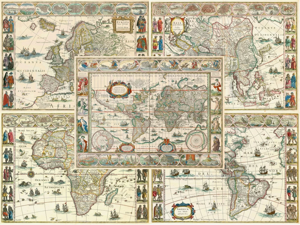
Nova Totius Terrarum Orbis Geographica ac Hydrographica. 1643-50
Willem Blaeu, set of 5 maps: World & continents.
[Item number: 24287]
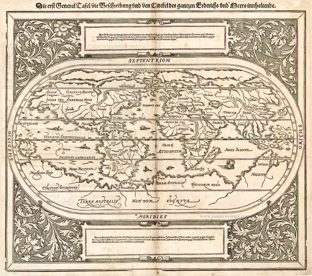
Die erst General Tafel / die Beschreibung und den Circkel des gantzen Erdtrichs und Meers innhaltende. 1588
World by Sebastian Münster.
[Item number: 25622]

Rare variant.
Cosmographia Universalis. 1592
World map by H. Bünting - D.A. Veleslavina.
[Item number: 26356]
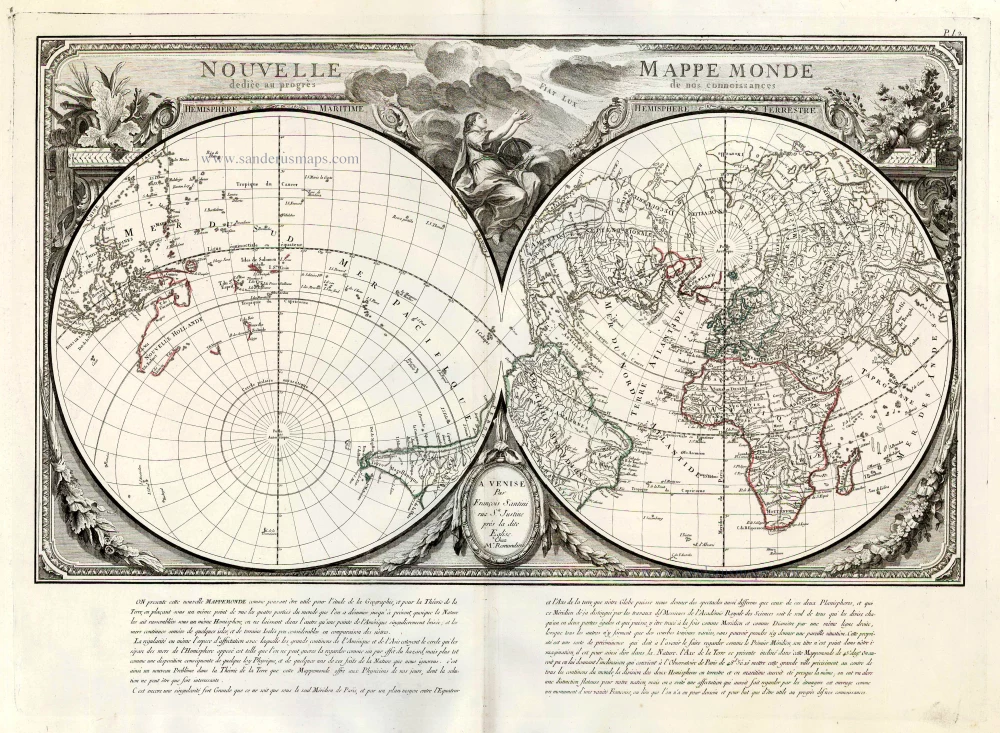
Nouvelle Mappe Monde Dediee au Progres de nos Connoissances. 1776-79
World by Francesco Santini.
[Item number: 26946]

Universi Orbis Descriptio. 1597
World by Giovanni Magini
[Item number: 27837]

A fine ornate example of the decorative cartography of the time.
Nova Totius Terrarum Orbis Geographica ac Hydrographica Tabula. Auct: Henr: Hondio. 1641
Double-hemisphere world map by Henricus Hondius.
[Item number: 28768]
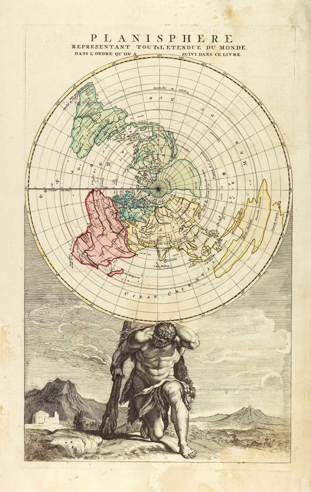
Planisphere representant toute l'Etendue du Monde, dans l'ordre qu'on a suivi dans ce livre. 1792
World in north polar azimuthal projection.
[Item number: 28810]

Luxury colouring.
Orbis Terrarum Nova et Accuratissima Tabula. c. 1678
Double-hemisphere world map, by Nicolaas Visscher I.
[Item number: 28934]