Dillenburg and Siegen, by Georg Braun and Frans Hogenberg. c. 1625
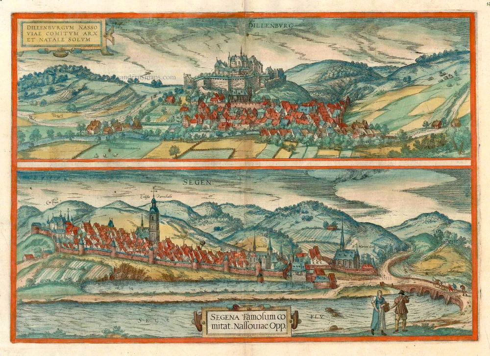


DILLENBURG
CARTOUCHE: Dillenburg, castle and ancestral seat of the Counts of Nassau.
COMMENTARY BY BRAUN: "The Nassau castle of Dillenburg lies on the Dill, from which it takes its name, like the whole valley through which the river flows. It is a very handsome, well-built and mighty castle with splendid rooms and apartments, and in addition it is fortified with walls, ramparts and moats."
This view from the north looking down from a high viewpoint is dominated by the well-fortified castle dating from the 13th century, which was the ancestral seat of the Counts of Nassau-Dillenburg. William I of Orange-Nassau, who was born here in 1533, organized the Dutch Revolt against Spain from here from 1567 to 1572. Below the castle is the settlement with the church of St John. The plate documents the appearance of Dillenburg around 1590, when the little town was still unfortified, except for one section in the west; the town wall was built between 1588 and 1618.
SIEGEN
CARTOUCHE: Siegen, famous town in the County of Nassau.
COMMENTARY BY BRAUN: "The mountains close by are full of iron and also some other metals, and there is therefore a large iron industry here, the iron being forged and cast and exported to all regions. And although it is a rather bleak country in which delicate fruits cannot thrive, there is no lack of those things that are essential to life, especially as regards agriculture and livestock."
In this foreshortened view of Siegen from the northwest the church of St Nicholas dominates with its height. To the right of it can be seen the Franciscan monastery, on the site of which the Lower Castle was built at the beginning of the 18th century. St Martin's church on the far right is Siegen's oldest church. The first settlement grew up at a ford, which was important for trade traffic; the first mention of it dates from the 11th century and it was granted city rights in the 12th century. The Upper Castle, residence of the Counts of Nassau-Siegen, can be seen on the left. The figures in peasant dress underline the city's importance as a market town, and the loaded mule is a reference to it being a centre of mining.
Braun G. & Hogenberg F. and the Civitates Orbis Terrarum.
The Civitates Orbis Terrarum, or the "Braun & Hogenberg", is a six-volume town atlas and the most excellent book of town views and plans ever published: 363 engravings, sometimes beautifully coloured. It was one of the best-selling works in the last quarter of the 16th century. Georg Braun wrote the text accompanying the plans and views on the verso. Many plates were engraved after the original drawings of a professional artist, a professional artist, Joris Hoefnagel (1542-1600). The first volume was published in Latin in 1572, and the sixth in 1617. Frans Hogenberg created the tables for volumes I through IV, and Simon van den Neuwel made those for volumes V and VI. Other contributors were cartographers Daniel Freese and Heinrich Rantzau. Works by Jacob van Deventer, Sebastian Münster, and Johannes Stumpf were also used. Translations appeared in German and French.
Following the original publication of Volume 1 of the Civitates in 1572, seven further editions of 1575, 1577, 1582, 1588, 1593, 1599 and 1612 can be identified. Vol.2, first issued in 1575, was followed by further editions in 1597 and 1612. The subsequent volumes appeared in 1581, 1588, 1593, 1599 and 1606. The German translation of the first volume appeared from 1574 on, and the French edition from 1575 on.
Several printers were involved: Theodor Graminaeus, Heinrich von Aich, Gottfried von Kempen, Johannis Sinniger, Bertram Buchholtz and Peter von Brachel, who all worked in Cologne.
Georg Braun (1541-1622)
Georg Braun was born in Cologne in 1541. After his studies in Cologne, he entered the Jesuit Order as a novice. 1561, he obtained his bachelor's degree, and in 1562, he received his Magister Artium. Although he left the Jesuit Order, he studied theology, gaining a licentiate in theology.
Frans Hogenberg (1535-1590)
Frans Hogenberg was a Flemish and German painter, engraver, and mapmaker. He was born in Mechelen as the son of Nicolaas Hogenberg.
By the end of the 1560s, Frans Hogenberg was employed upon Abraham Ortelius's Theatrum Orbis Terrarum, published in 1570; he is named an engraver of numerous maps. In 1568, he was banned from Antwerp by the Duke of Alva and travelled to London, where he stayed a few years before emigrating to Cologne. He immediately embarked on his two most important works, the Civitates, published in 1572 and the Geschichtsblätter, which appeared in several series from 1569 until about 1587.
Thanks to large-scale projects like the Geschichtsblätter and the Civitates, Hogenberg's social circumstances improved with each passing year. He died as a wealthy man in Cologne in 1590.
Dillenburgum Nassoviae Comitum Arx Natale Solum [on sheet with:] Segena Famosum Comitat. Nassoviae Opp.
Item Number: 16410 Authenticity Guarantee
Category: Antique maps > Europe > Germany - Cities
Old, antique bird’s-eye view of Dillenburg and Siegen, by Georg Braun and Frans Hogenberg.
Title: Dillenburgum Nassoviae Comitum Arx Natale Solum [on sheet with:] Segena Famosum Comitat. Nassoviae Opp.
Date of the first edition: 1617.
Date of this map: c. 1625.
Copper engraving, printed on paper.
Size (not including margins): 340 x 485mm (13.39 x 19.09 inches).
Verso: French text.
Condition: Original coloured, excellent.
Condition Rating: A+.
From: Théatre des Principales Villes de tout l'Univers Vol. VI. c. 1625. (Van der Krogt 4, 41:3.6)
DILLENBURG
CARTOUCHE: Dillenburg, castle and ancestral seat of the Counts of Nassau.
COMMENTARY BY BRAUN: "The Nassau castle of Dillenburg lies on the Dill, from which it takes its name, like the whole valley through which the river flows. It is a very handsome, well-built and mighty castle with splendid rooms and apartments, and in addition it is fortified with walls, ramparts and moats."
This view from the north looking down from a high viewpoint is dominated by the well-fortified castle dating from the 13th century, which was the ancestral seat of the Counts of Nassau-Dillenburg. William I of Orange-Nassau, who was born here in 1533, organized the Dutch Revolt against Spain from here from 1567 to 1572. Below the castle is the settlement with the church of St John. The plate documents the appearance of Dillenburg around 1590, when the little town was still unfortified, except for one section in the west; the town wall was built between 1588 and 1618.
SIEGEN
CARTOUCHE: Siegen, famous town in the County of Nassau.
COMMENTARY BY BRAUN: "The mountains close by are full of iron and also some other metals, and there is therefore a large iron industry here, the iron being forged and cast and exported to all regions. And although it is a rather bleak country in which delicate fruits cannot thrive, there is no lack of those things that are essential to life, especially as regards agriculture and livestock."
In this foreshortened view of Siegen from the northwest the church of St Nicholas dominates with its height. To the right of it can be seen the Franciscan monastery, on the site of which the Lower Castle was built at the beginning of the 18th century. St Martin's church on the far right is Siegen's oldest church. The first settlement grew up at a ford, which was important for trade traffic; the first mention of it dates from the 11th century and it was granted city rights in the 12th century. The Upper Castle, residence of the Counts of Nassau-Siegen, can be seen on the left. The figures in peasant dress underline the city's importance as a market town, and the loaded mule is a reference to it being a centre of mining.
Braun G. & Hogenberg F. and the Civitates Orbis Terrarum.
The Civitates Orbis Terrarum, or the "Braun & Hogenberg", is a six-volume town atlas and the most excellent book of town views and plans ever published: 363 engravings, sometimes beautifully coloured. It was one of the best-selling works in the last quarter of the 16th century. Georg Braun wrote the text accompanying the plans and views on the verso. Many plates were engraved after the original drawings of a professional artist, a professional artist, Joris Hoefnagel (1542-1600). The first volume was published in Latin in 1572, and the sixth in 1617. Frans Hogenberg created the tables for volumes I through IV, and Simon van den Neuwel made those for volumes V and VI. Other contributors were cartographers Daniel Freese and Heinrich Rantzau. Works by Jacob van Deventer, Sebastian Münster, and Johannes Stumpf were also used. Translations appeared in German and French.
Following the original publication of Volume 1 of the Civitates in 1572, seven further editions of 1575, 1577, 1582, 1588, 1593, 1599 and 1612 can be identified. Vol.2, first issued in 1575, was followed by further editions in 1597 and 1612. The subsequent volumes appeared in 1581, 1588, 1593, 1599 and 1606. The German translation of the first volume appeared from 1574 on, and the French edition from 1575 on.
Several printers were involved: Theodor Graminaeus, Heinrich von Aich, Gottfried von Kempen, Johannis Sinniger, Bertram Buchholtz and Peter von Brachel, who all worked in Cologne.
Georg Braun (1541-1622)
Georg Braun was born in Cologne in 1541. After his studies in Cologne, he entered the Jesuit Order as a novice. 1561, he obtained his bachelor's degree, and in 1562, he received his Magister Artium. Although he left the Jesuit Order, he studied theology, gaining a licentiate in theology.
Frans Hogenberg (1535-1590)
Frans Hogenberg was a Flemish and German painter, engraver, and mapmaker. He was born in Mechelen as the son of Nicolaas Hogenberg.
By the end of the 1560s, Frans Hogenberg was employed upon Abraham Ortelius's Theatrum Orbis Terrarum, published in 1570; he is named an engraver of numerous maps. In 1568, he was banned from Antwerp by the Duke of Alva and travelled to London, where he stayed a few years before emigrating to Cologne. He immediately embarked on his two most important works, the Civitates, published in 1572 and the Geschichtsblätter, which appeared in several series from 1569 until about 1587.
Thanks to large-scale projects like the Geschichtsblätter and the Civitates, Hogenberg's social circumstances improved with each passing year. He died as a wealthy man in Cologne in 1590.