Antique maps catalogue
- All recent additions
-
Antique maps
- World and Polar
-
Europe
- Europe Continent
- Belgium
- Belgium - Cities
- The Low Countries
- The Netherlands
- The Netherlands - Cities
- Luxembourg
- France
- France - Cities
- Germany
- Germany - Cities
- Austria
- Italy
- Italy - Cities
- Spain and Portugal
- Greece & Greek Islands
- Switzerland
- British Isles
- British Isles - Cities
- Northern Europe
- Central Europe
- Eastern Europe
- Southeastern Europe
- America
- Asia
- Africa
- Mediterranean Sea
- Australia
- Oceans
- Celestial Maps
- Curiosities
- Books
- Medieval manuscripts
- Prints
Rare original colour
Sebastian Münster, world map 1550
Typus Orbis Universalis.
[Item number: 29795]
Ptolemaic world by Sebastian Münster 1559
Altera Generalis Tab. Secundum Ptol.
[Item number: 11981]
World, by Abraham Ortelius. 1579
Typus Orbis Terrarum.
[Item number: 28640]
'One of the supreme examples of map maker's art' (Shirley)
World in Mercator projection, by Willem Blaeu. 1643
Nova Totius Terrarum Orbis Geographica ac Hydrographica.
[Item number: 30271]
Superb world set.
Abraham Ortelius, 1584 World and Continents 1584
Typus Orbis Terrarum [in set with] Africae Tabula Nova [and] ...
[Item number: 29259]
Superb condition
Willem Blaeu, set of 5 maps: World & continents. 1643-50
Nova Totius Terrarum Orbis Geographica ac Hydrographica.
[Item number: 24287]
A fine ornate example of the decorative cartography of the time.
Double-hemisphere world map by Henricus Hondius. 1641
Nova Totius Terrarum Orbis Geographica ac Hydrographica Tabula. ...
[Item number: 28768]
The engraving and layout and elegance of decoration are all of the highest standards.
World by Joan Blaeu, double hemisphere. 1659
Nova Et Accuratissima Totius Terrarum Orbis Tabula.
[Item number: 28336]
World by Nicolaas Visscher, double hemisphere. c. 1678
Orbis Terrarum Nova et Accuratissima Tabula.
[Item number: 28628]
Luxury colouring.
Double-hemisphere world map, by Nicolaas Visscher I. c. 1678
Orbis Terrarum Nova et Accuratissima Tabula.
[Item number: 28934]
World by Frederik De Wit, double hemisphere. c. 1690
Nova Orbis Tabula in Lucem Edita, A. F. De Wit.
[Item number: 29231]
World by Pieter Van der Aa - double hemisphere. 1702
Nova Delineatio Totius Orbis Terrarum per Petrum Van der Aa. - ...
[Item number: 30150]
World by Pieter Van der Aa, double hemisphere. 1710
Nouvelle Mappe-Monde,
[Item number: 29136]
World by Zürner A.F., double hemisphere. c. 1700
Planisphaerium Terrestre cum utroque Coelesti Hemisphaerio, sive ...
[Item number: 28229]
World by Homann J.B., double hemisphere. c. 1720
Planiglobii Terrestris cum Utroq Hemisphaerio Caelesti Generalis ...
[Item number: 29066]
World chart by Girolamo Ruscelli. 1561
Carta Marina Nuova Tavola.
[Item number: 30380]
new
Rare variant.
World map by H. Bünting - D.A. Veleslavina. 1592
Cosmographia Universalis.
[Item number: 26356]
Ptolemaic world map by Giuseppe Rosaccio. 1598
Ptolemaei Cognita.
[Item number: 28290]
World by Sebastian Münster. 1588
Die erst General Tafel / die Beschreibung und den Circkel des ...
[Item number: 25622]
One of the first double hemisphere world maps.
World by Girolamo Ruscelli. 1564
Orbis Descriptio.
[Item number: 27838]
The world by Abraham Ortelius / Philippe Galle. 1589
Typus Orbis Terrarum.
[Item number: 29605]
First edition
World by Giuseppe Rosaccio, double hemisphere. 1598
Orbis Terrae Compendiosa Descriptio.
[Item number: 28289]
World by Giovanni Magini 1597
Universi Orbis Descriptio.
[Item number: 27837]
World by Barent Langenes 1602
Typus Orbis Terrarum.
[Item number: 12009]
Rare original colour.
Two world maps by A. Ortelius, published by J.B. Vrients. 1609
Typus Orbis Terrarum - Globus Terrestris.
[Item number: 29861]
Heightened in gold
Drake set in superb old colouring. 1599
[Item number: 28235]
California as an island
World map by Hubert Jaillot, double hemisphere. c. 1705
Mappe-Monde Geo-Hydrographique, ou Description Generale du Globe ...
[Item number: 27852]
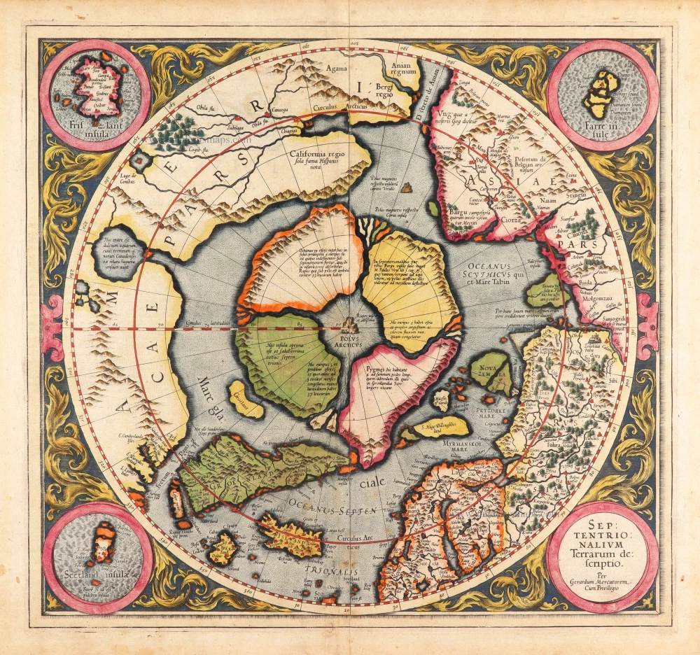
Very rare first state of Mercator's North Pole map.
Arctic Region - North Pole by Gerard Mercator, first state published by Rumold Mercator. 1595
Septentrionalium Terrarum descriptio.
[Item number: 29799]
Second state of the first separate map of the Arctic Regions.
North Pole, by Mercator Gerard. 1628
Septentrionalium Terrarum descriptio.
[Item number: 30315]
Scarce.
Arctic Region by Petrus Bertius. 1618
[Title above map:] La Description des Hyperborees.
[Item number: 28390]
North Pole by Henricus Hondius. 1637
Poli Arctici et Circumiacentium Terrarum Descriptio Novissima.
[Item number: 30055]
First state, 'Henricus Hondius'.
South Pole, by Henricus Hondius. 1637
Polus Antarcticus.
[Item number: 30054]
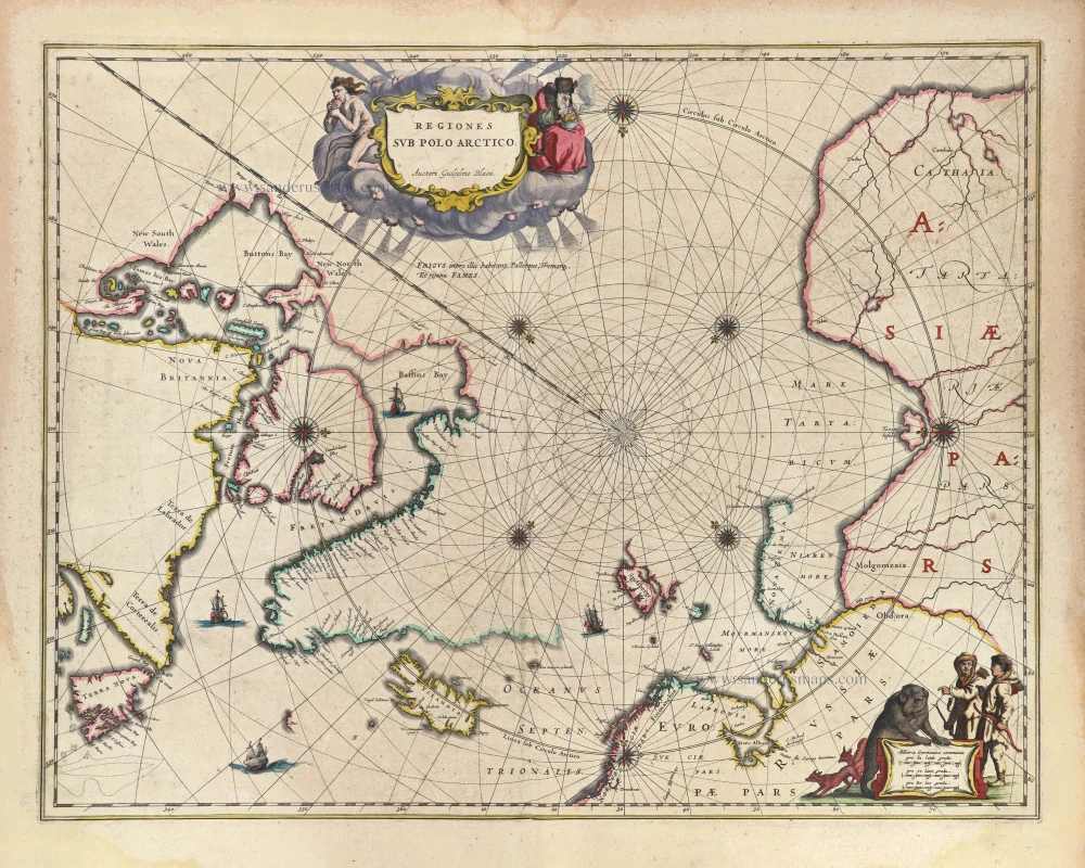
Arctic Region, by Joan Blaeu 1643
Regiones sub Polo Arctico.
[Item number: 29447]
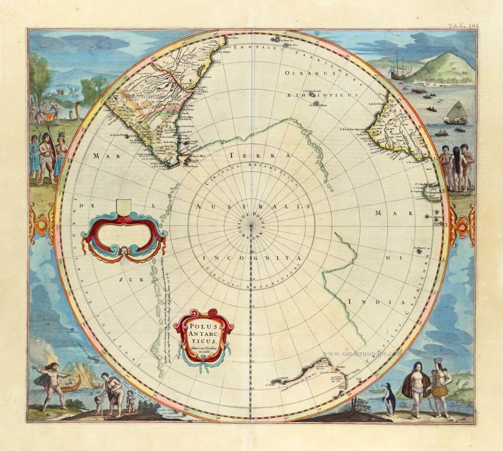
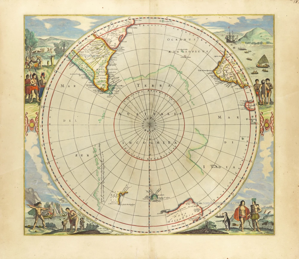
Scarce edition with New Zeeland & Tasmania by J. Janssonius.
South Pole, by Henricus Hondius, published by J. Janssonius. 1666
Polus Antarcticus.
[Item number: 30316]
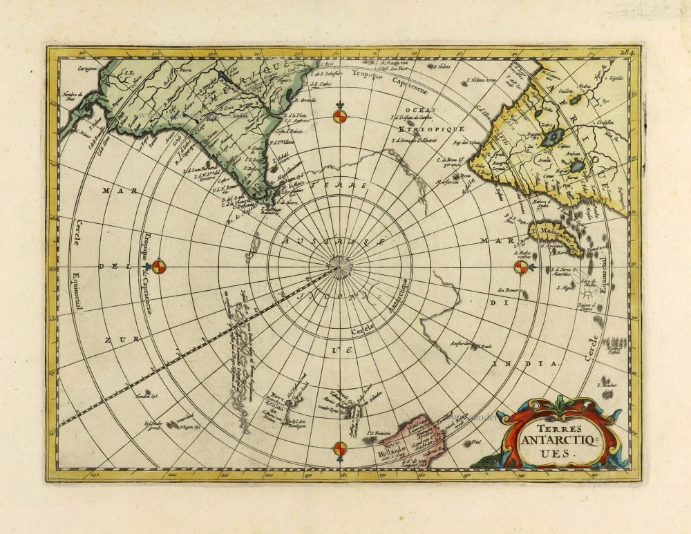
World by Francesco Santini. 1776-79
Nouvelle Mappe Monde Dediee au Progres de nos Connoissances.
[Item number: 26946]
The most mystical world map of all time.
Daniel's Dream Map. The Wittenberg world map. 1560-1600
[No title]
[Item number: 28159]