Antique maps catalogue
- All recent additions
-
Antique maps
- Polar maps
- World
-
Europe
- Europe Continent
- Belgium
- Belgium - Cities
- The Low Countries
- The Netherlands
- The Netherlands - Cities
- Luxembourg
- France
- France - Cities
- Germany
- Germany - Cities
- Austria
- Italy
- Italy - Cities
- Spain and Portugal
- Greece & Greek Islands
- Switzerland
- British Isles
- British Isles - Cities
- Northern Europe
- Central Europe
- Eastern Europe
- Southeastern Europe
- America
- Asia
- Africa
- Mediterranean Sea
- Australia
- Oceans
- Celestial Maps
- Curiosities
- Title Pages
- Books
- Medieval manuscripts
- Prints

Holland, by Abraham Ortelius. 1584
Hollandiae Antiquorum Catthorum Sedis Nova Descriptio.
[Item number: 29547]
Holland by Petrus Kaerius (Pieter Van den Keere). 1617
Hollandia.
[Item number: 30257]
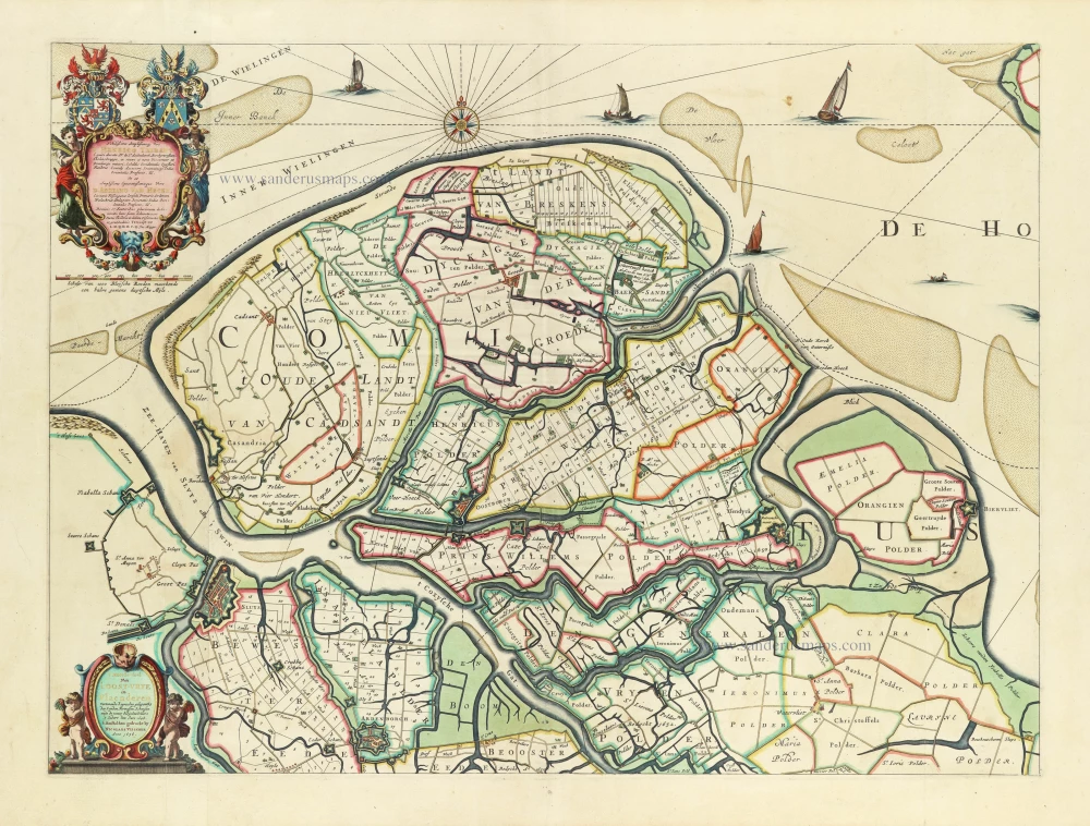
Rare Visscher map of Het Zwin, in a stunning colouring and gold-heightened, all in the style of Dirk Van Santen
Oost-Vrije (West Zeeuws-Vlaanderen), by Nicolaes Visscher. 1656
't Meerderdeel van 't OOST-VRYE in Vlaenderen Vertonende...
[Item number: 32588]

First edition, first state. Dutch text. Important map!
Lucas Janszoon Waghenaer, Holland. 1584
Beschrijvinge vande vermaerde stroemen, Tvlie ende Tmaersdiep;...
[Item number: 27007]
new

Scarce and decorative map
Gelderland, by Claes Jansz Visscher. 1634
Ducatus Geldriae nec non Comitatus Zutphiae cum adjacentibus...
[Item number: 28004]

Early edition
Zeeland by Abraham Ortelius. 1573
Zelandicarum Insularum exactissima et nova descriptio,
[Item number: 30967]
![[No title - With inset view of the town of Middelburg:] Middelburgum. [Costumed figures:] Seelandi](https://sanderusmaps.com/assets/IMG/webp/m30935.webp)
Zeeland by Petrus Kaerius, published by C.J. Visscher. c. 1630-1650
[No title - With inset view of the town of Middelburg:]...
[Item number: 30935]

Zeeland by M. Smallegange, published by P. van der Aa. 1728
Naeukeurige Nieuwe Land-Caert des Graefschaps Zeeland.
[Item number: 33042]
new

Rare and important map!
Holland, by Camocio G.F. - Forlani P. 1563
Hollandiae Batavor Veteris Insulae Locorum Adiacentium Exacta...
[Item number: 9232]

Second printed Holland map.
Holland by Sebastian Münster. 1552
Hola(n)d.
[Item number: 27467]
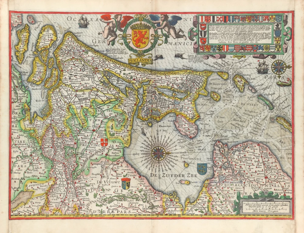
Holland by Willem Blaeu 1643
Hollandia Comitatus.
[Item number: 30182]

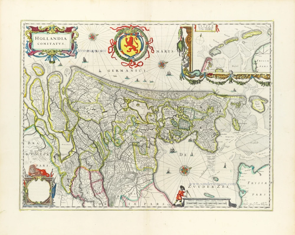
Holland, by Janssonius J. 1638
Comitatus Hollandiae novissima descriptio.
[Item number: 19020]

Holland by Henricus Hondius 1638
Comitatus Hollandiae novissima descriptio.
[Item number: 32448]
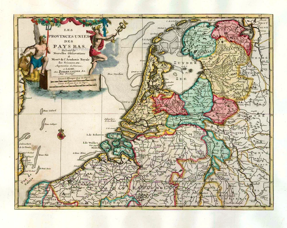
The VII Provinces, by Pieter Van der Aa. 1713
Les Provinces Unies des Pays-Bas.
[Item number: 26060]
VII Provinces by Caspar Specht, published by R. & J. Ottens. After 1726
Exactissima Belgii Foederati Tabula cum annexis divisa in...
[Item number: 28711]

Republic of the VII Provinces, by Nicolaes Visscher I. 1658-80
Belgium Foederatum.
[Item number: 28589]
Rare first state
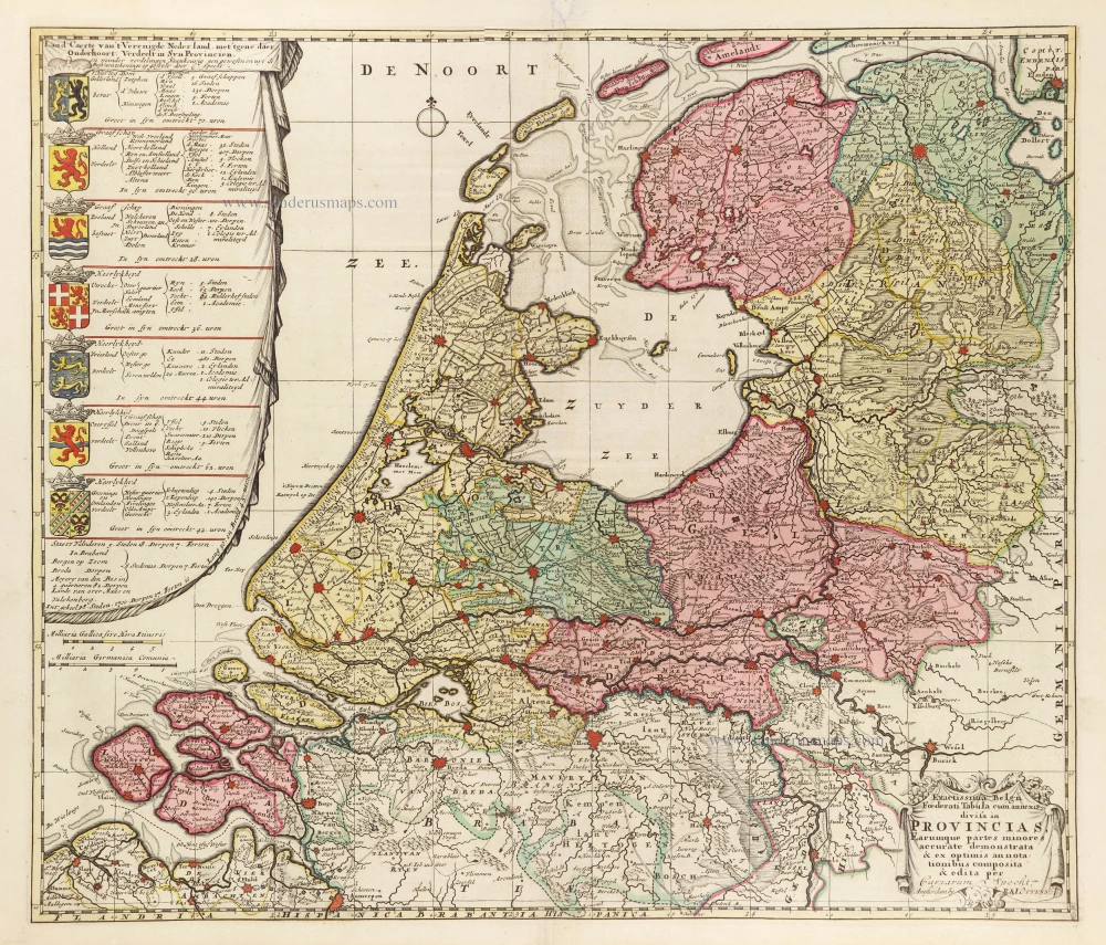
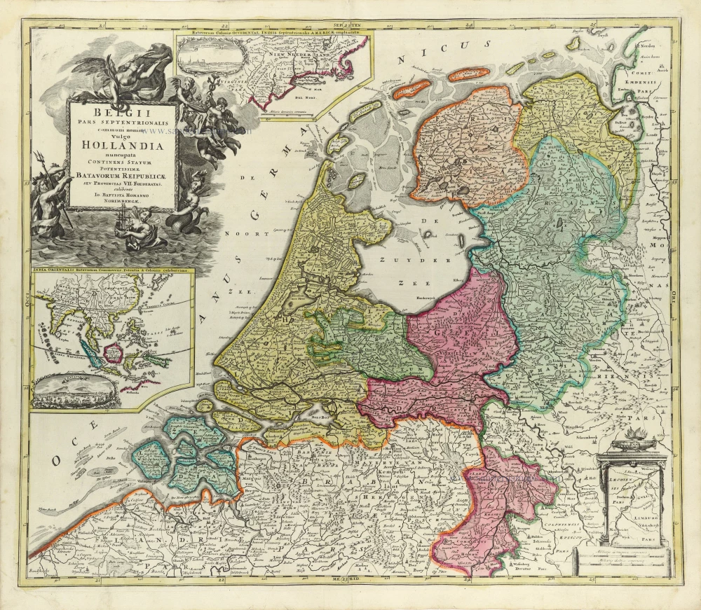
VII Provinces (Seven Provinces), by J.B. Homann. 1707
Belgii Pars Septentrionalis communi nomine vulgo Hollandia
[Item number: 32466]
Rare!
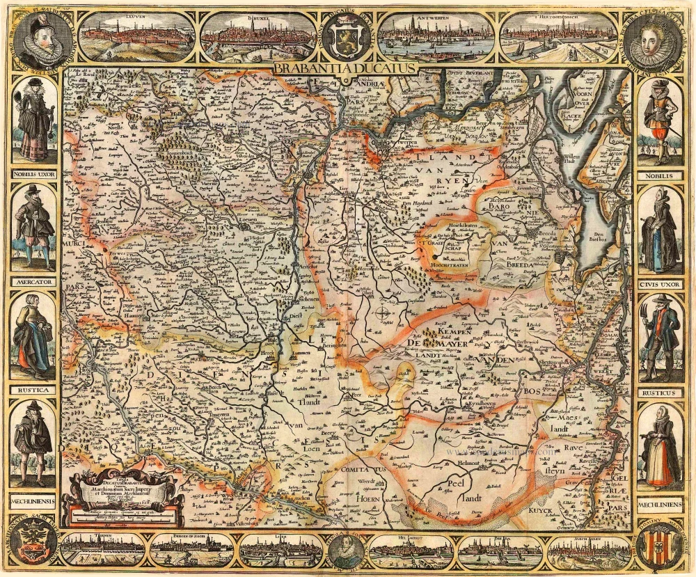
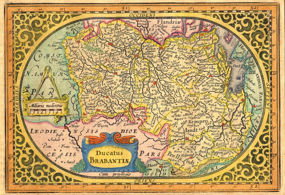
Brabant by Pieter Verbiest 1628
Brabantia Ducatus / Tabula Ducatus Brabantiae Continens...
[Item number: 27743]
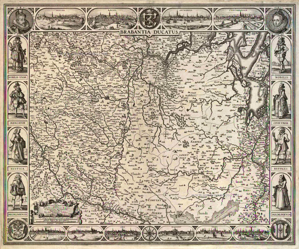
Brabant by C.J. Visscher. 1622
Brabantia Ducatus / Tabula Ducatus Brabantiae Continens...
[Item number: 2640]

Holland by Hendrick Doncker. 1686
De Cust van Hollandt Tusschen de Maes en Texel.
[Item number: 15677]

Sea chart of Holland, by Pieter Goos. 1667
Cust van Hollant tusschen de Maes ende Texel
[Item number: 19040]

Big and spectacular map
Holland, by Pieter Mortier. c. 1705
Le Comté de Hollande.
[Item number: 27807]

Holland by C. Specht, published by R. & J. Ottens. 1730-45
Kaart van 't Graafschap Holland Naauwkeurig Afgedeelt in zyne...
[Item number: 25706]
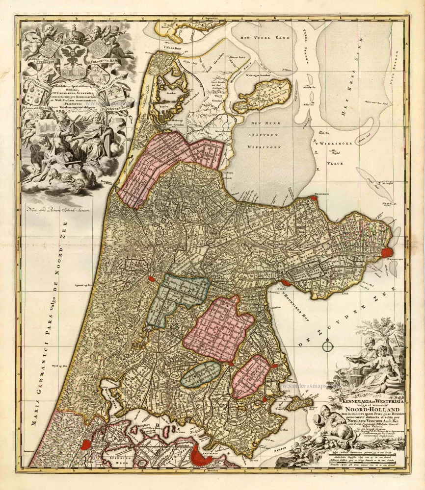
Noord Holland by Nicolaas Visscher I, published by Petrus Schenk. c. 1700
Kennemaria et Westfrisia vulgo et vernaculé Noord-Holland.
[Item number: 25707]

Holland by Pieter Van der Aa. 1713
La Hollande.
[Item number: 26059]

Important and rare map.
Brabant, by Michele Tramezini. 1558
Brabantiae Belgarum Provinciae Recens Exactaque Descriptio.
[Item number: 26713]

Scarce map
Polder map of Holland, by Nicolaas Visscher, published by Petrus Schenk Jr. c. 1750
Afbeeldinge van zeker concept tot bedykinge van de Haarlemer,...
[Item number: 28918]

Brabant by Abraham Ortelius 1572
Brabantiae Germaniae Inferioris Nobilissimmae Provinciae...
[Item number: 26734]

Brabant, by A. Ortelius. 1595
Brabantiae Descriptio.
[Item number: 25573]

The Duchy of Brabant by Pieter van den Keere (Petrus Kaerius). 1617
Brabantia Ducatus Machliniae Urbis Dominium.
[Item number: 28672]

Brabant by M. Quad - J. Bussemacher. 1602
Brabantiae Belgarum provinciae recens exactaque descriptio.
[Item number: 25235]
Brabant by Abraham Goos,published by Joannes Janssonius. 1631
Ducatus Brabantiae.
[Item number: 17723]

Early map of the Low Countries, 1561-1574
Low Countries by Girolamo Ruscelli. 1574
Fiandra, Brabantia, et Holanda Nuova.
[Item number: 31083]

Very rare!
Rhine River by Cornelis Claesz. After 1630
Tabula geographica Prouinciarum Brabantiae, Geldriae comitatus...
[Item number: 27065]

Bergen op Zoom, by Visscher C.J. - Janssonius J. 1630
Kaerte van Bergen op Zoom. Steenbergen ende de Nieuwe...
[Item number: 26344]

Bergen op Zoom, by Visscher C.J. c. 1628-1650
Kaerte van Bergen op Zoom. Steenbergen ende de Nieuwe...
[Item number: 31000]