
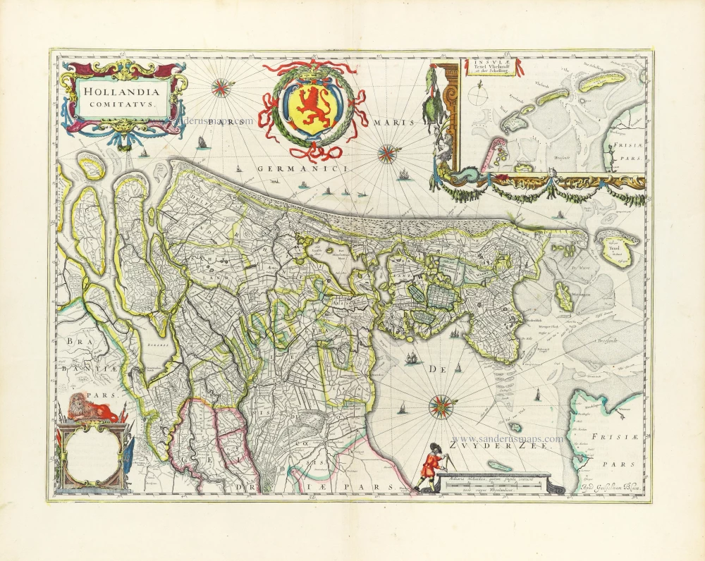
Sea chart of Holland, by Pieter Goos. 1667

"Pieter Goos' marine atlases were held to be among the finest printed at the time and were often added tot the nine or twelve volumes of Blaeu's Atlas Maior." (Shirley)
Pieter Goos (1615-1675)
Pieter Goos, son of the engraver Abraham Goos, was one of the best known maritime booksellers of Amsterdam. He was not only a bookseller but also a copper-engraver and even a book printer.
His first pilot book, the Lichtende Columne ofte Zee-Spiegel appeared in 1650. The well-made pilot guides and the beautiful sea-atlas reflect a high professional standard. The many editions published over 28 years is an indication of the customers’ appreciation. The Zeespiegel was printed in Dutch, French (1662), and English (1658). Goos printed all the time from the same 60 plates. For his Straetsboeck, being the third part of the Zeespiegel, Pieter Goos copied the text from Lootsman’s Straetboeck and copied also the plates. This atlas of the Mediterranean appeared in 1662.
Pieter Goos also published a fourth and fifth part of his Zeespiegel. For the fourth part, he used the second part of Het Brandende Veen by Arent Roggeveen, which dealt with the coasts of West-Africa (No copy with Goos’s imprint is known). For the fifth part, he used the first part of Het Brandende Veen, which appeared in 1675. It contains the charts and sailing directions for the West Indies.
The first edition of his sea-atlas, the Zee-Atlas ofte Water-Wereld, came out in 1666. For the design of the charts, Goos copied nearly all the charts from Hendrik Doncker’s sea-atlas. All the years through, till 1675 (the year of his death), the number of 40 or 41 maps remained the same.
When Pieter Goos died in March 1675, his widow continued the shop. She brought out a few new editions of the Zee-Atlas with 44 charts. Part of the atlases was sold then by the famous Amsterdam bookbinder Albert Magnus. These copies are renowned for their outstanding colouring. She died in 1677; their son, Hendrik Goos, born in 1641, took over and sold his father’s pilot books until 1680.
Cust van Hollant tusschen de Maes ende Texel
Item Number: 19040 Authenticity Guarantee
Category: Antique maps > Europe > The Netherlands
Old, antique sea chart of Holland, by Pieter Goos.
Title: Cust van Hollant tusschen de Maes ende Texel
Date: 1667.
Copper engraving, printed on paper.
Size (not including margins): 423 x 525mm (16.65 x 20.67 inches).
Verso: Blank.
Condition: Old coloured, minor offsetting, on heavy paper.
Condition Rating: A.
From: De Zee-Atlas, Ofte Water-Weereld, Waer in vertoont werden alle de Zee-Kusten Van het bekende des Aerd-Bodems. P. Goos, 1667. (Koeman, Goos1B)
"Pieter Goos' marine atlases were held to be among the finest printed at the time and were often added tot the nine or twelve volumes of Blaeu's Atlas Maior." (Shirley)
Pieter Goos (1615-1675)
Pieter Goos, son of the engraver Abraham Goos, was one of the best known maritime booksellers of Amsterdam. He was not only a bookseller but also a copper-engraver and even a book printer.
His first pilot book, the Lichtende Columne ofte Zee-Spiegel appeared in 1650. The well-made pilot guides and the beautiful sea-atlas reflect a high professional standard. The many editions published over 28 years is an indication of the customers’ appreciation. The Zeespiegel was printed in Dutch, French (1662), and English (1658). Goos printed all the time from the same 60 plates. For his Straetsboeck, being the third part of the Zeespiegel, Pieter Goos copied the text from Lootsman’s Straetboeck and copied also the plates. This atlas of the Mediterranean appeared in 1662.
Pieter Goos also published a fourth and fifth part of his Zeespiegel. For the fourth part, he used the second part of Het Brandende Veen by Arent Roggeveen, which dealt with the coasts of West-Africa (No copy with Goos’s imprint is known). For the fifth part, he used the first part of Het Brandende Veen, which appeared in 1675. It contains the charts and sailing directions for the West Indies.
The first edition of his sea-atlas, the Zee-Atlas ofte Water-Wereld, came out in 1666. For the design of the charts, Goos copied nearly all the charts from Hendrik Doncker’s sea-atlas. All the years through, till 1675 (the year of his death), the number of 40 or 41 maps remained the same.
When Pieter Goos died in March 1675, his widow continued the shop. She brought out a few new editions of the Zee-Atlas with 44 charts. Part of the atlases was sold then by the famous Amsterdam bookbinder Albert Magnus. These copies are renowned for their outstanding colouring. She died in 1677; their son, Hendrik Goos, born in 1641, took over and sold his father’s pilot books until 1680.
Related items

Hollandiae pars Meridionalis, vulgo Zuyd-Holland 1683-1696
Holland (South), by N. Visscher.
[Item number: 10962]

Paskaarte om Achter Yrlandt om te Zeylen van Hitlant tot aen Heyssat Nieuwlycx Uytgegeven 1667
The British Isles, by Pieter Goos.
[Item number: 19046]

Paskaert van de Zeeusche en Vlaemsche Kusten, tonende Alle Drooghten, Diepten, en Ondiepten, tusschen t'Eylandt Schouwen en de Hoofden, Curieuselyck Beschreven door Dirck Davidsz 1667
Sea chart of Flanders (Vlaanderen) & Zeeland, by Pieter Goos.
[Item number: 19054]

Pas-Caart van Guinea en de Custen daer aen Gelegen van Cabo Verde tot Cabo de Bona Esperanca 1667
Sea chart of Guinea, by Pieter Goos.
[Item number: 19060]

De Texel Stroom met de gaten vant Marsdiep. [On sheet with:] Caarte van De Mase ende het Goereesche Gat 1667
Sea chart of Texel & Maas, by Pieter Goos.
[Item number: 19068]

Pas-Kaarte van de Zuyd-West-Kust van Afrika; van Cabo Negro tot Beoosten Cabo de Bona Esperanca 1667
Sea chart of South African Coast, by Pieter Goos.
[Item number: 19073]

Delflandia, Schielandia et circumjacentes Insulae ... 1680-1710
Holland, by N. Visscher
[Item number: 24417]

Delflandia, Schielandia et Insulae trans Mosam et Insulae trans Mosam illis objacentes ut sunt Voorna, Overflackea, Goerea, Yselmonda, etc. 1635
Holland (Southwest), by Willem Blaeu.
[Item number: 25352]

Kaart van 't Graafschap Holland Naauwkeurig Afgedeelt in zyne Heemraadschappen, Baljuwschappen en Waarden, 1730-45
Holland by C. Specht, published by R. & J. Ottens.
[Item number: 25706]
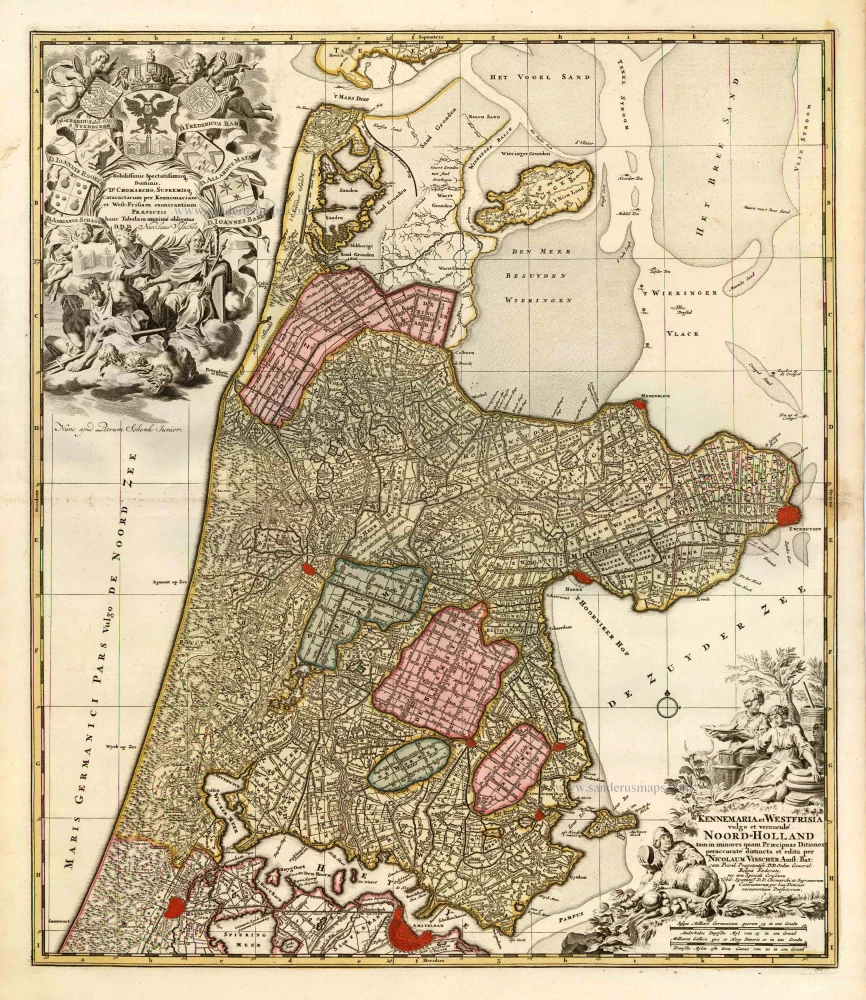
Kennemaria et Westfrisia vulgo et vernaculé Noord-Holland. c. 1700
Noord Holland by Nicolaas Visscher I, published by Petrus Schenk.
[Item number: 25707]

Hollandiae Pars Meridionalior, Vulgo Zuyd-Holland. c. 1740
Southern Holland by Nicolaas Visscher II, published by Petrus Schenk.
[Item number: 25721]

Rhenolandia, Amstelandia et Circumjacentia aliquot Territoria, cum Aggeribus omnibus, Terminiqz fuis. c. 1740
Central Holland by Nicolaas Visscher II, published by Petrus Schenk.
[Item number: 25722]

La Hollande. 1713
Holland by Pieter Van der Aa.
[Item number: 26059]

Scarce map
Afbeeldinge van zeker concept tot bedykinge van de Haarlemer, Leydse en andere byleggende Meeren. c. 1750
Polder map of Holland, by Nicolaas Visscher, published by Petrus Schenk Jr.
[Item number: 28918]

Hollandiae Antiquorum Catthorum Sedis Nova Descriptio. 1584
Holland, by Abraham Ortelius.
[Item number: 29547]
Hollandia Comitatus. 1643
Holland by Willem Blaeu
[Item number: 30182]
Hollandia. 1617
Holland by Petrus Kaerius (Pieter Van den Keere).
[Item number: 30257]

Hollandiae Antiquorum Catthorum Sedis Nova Descriptio. 1603
Holland, by Abraham Ortelius.
[Item number: 31103]
Hollandia Comitatus. 1647
Holland by Willem Blaeu
[Item number: 31104]

Hollandia. 1618
Holland by Petrus Bertius, published by Jodocus Hondius II.
[Item number: 31589]

Carte de Hollande. 1633
Holland by C. Tassin.
[Item number: 31762]

Novißima Tabula Insular. Dordracensis, Alblasser, Crimper, Clundert etc: Comprehens item Territoria Vianae, Goricomii, Leerdami, Altenae, Heusdenae, ac Civitates ... 1638
Holland (Southeast), by Henricus Hondius.
[Item number: 32446]

Comitatus Hollandiae novissima descriptio. 1638
Holland by Henricus Hondius
[Item number: 32448]