
Scarce map
Polder map of Holland, by Nicolaas Visscher, published by Petrus Schenk Jr. c. 1750

The Visscher Family
For nearly a century, the members of the Visscher family were essential art dealers and map publishers in Amsterdam.
Claes Jansz. Visscher, or N.J. Piscator (1587-1652)
Claes Jansz. Vischer bought a house in Amsterdam, 'de gulden Bors', on the crucial Kalverstraat and changed the name into "In de Visscher"; under this title, the shop was to flourish for many years.
He was famous for his engravings and etchings of Dutch landscapes and 'historical scenes', such as sieges, battles, etc. These 'historical scenes' were considered contemporary illustrated news items, especially e.g. that of 'the Eighty Years' War'.
For the publication of his first atlas, he bought copperplates of the atlas Germania Inferior by Pieter van den Keere (1623).
In 1649, he published an atlas entitled Tabularum Geographicarum Contractarum, containing the same maps as Langenes' Caert Thresoor, for which Visscher had only new title pages engraved.
Claes Jansz. Visscher died in 1652. His wife, Neeltjen Florisdr., had already died in 1640. They had seven children, four of whom were still alive at Claes Jansz.'s death. One was Nicolaes Visscher I, who was to continue his father's business.
Nicolaes Visscher I (1618-1679)
Nicolaes Visscher I partnered with his father, continued the business, and stayed on the Kalverstraat 'in de Visscher' till his death.
In about 1657, the first edition of his Atlas Contractus Orbis Terrarum appeared.
Between 1664 and 1677, several editions of his Atlas Contractus appeared without a printed index, for these atlases had no fixed contents but were composed according to the buyer's financial leaping pole.
In May 1664, Nicolaes Visscher was admitted as a member of the Booksellers' Guild of his town. In July 1677, he was granted a patent of the States of Holland and West-Friesland for printing and publishing maps and atlases for 15 years.
After this, he again published an Atlas Contractus with a printed index. At about the same time, he also brought out an Atlas Minor.
Nicolaes Visscher II (1649-1702)
Nicolaes Visscher II inherited the 'shop' from his father. To obtain a new privilege, he applied to the States of Holland and West-Friesland in 1682 for a patent for printing and publishing maps. This patent was granted to him the same year. He moved the firm to the Dam, but it kept the same signboard: "In de Visscher".
Around 1683, he published his first Atlas Minor with a printed index of 91 maps. In 1684, an atlas Germania Inferior appeared. Till 1697, he published another number of atlases. He used his grandfather's (Claes Jansz.) maps less often now and relied more and more on his own.
The wars waged at this time initiated the compilation of maps of the countries where the armies operated. Many war maps were included in the various editions of his Atlas Minor.
After Nicolaes's death, his wife, Elizabeth Verseyl, published all the war maps as an atlas under the title De Stoel des Oorlogs in de Wereld (The seat of war in the world).
The widow of Nicolaes Visscher II (?-1726)
His widow continued the business energetically, and by her hand, under the name of her deceased husband, numerous atlases appeared, e.g., several editions of the Atlas Minor, an Atlas Maior and De Stoel des Oorlogs. The shop enjoyed a high reputation due to the assortment's incredible variety. Not only 'Visscher' maps but also maps of other publishers were obtainable. With the death of Elizabeth Verseyl in 1726, the last descendant died of a great map- and atlas-publishing firm in Amsterdam.
The Schenk Family
Petrus Schenk (1660-1718), the founder of one of the best-known publishing firms of Amsterdam in the 18th century, was born in Elberfeld, Germany, in 1660. He went to Amsterdam where he became a pupil of the engraver Gerard Valck. On 19 Nov. 1686, a privilegio was granted to Petrus Schenk and Gerard Valk for the manufacturing and selling of their prints. Schenk’s contribution to cartography dates from c. 1695. In 1706 he moved to the Vijgendam in Amsterdam, ‘in Sanson’s Atlas’. After he died in 1718 his son, Leonardus Schenk, continued the art and print shop. The second son, Petrus II, settled in another famous house: ‘in Visscher’s Atlas’ where he continued the association with Gerard and Leonarus Valck.
The Schenk family produced general geographical atlases and special atlases. Apart from seventy original maps, several hundred are known with the name of Schenk, which were printed from plates obtained from Janssonius and Visscher. Schenk and Valck acquired all the plates of the Janssonius Heir’s Novus Atlas, Celestial atlas included. Many of Janssonius’ plates were reworked and amended.
The republishing of the maps from Janssonius’ Novus Atlas since c. 1680 was followed by the engraving of new maps, copied from Sanson’s better and more modern maps. Petrus Schenk published these maps in his Atlas Contractus sive mapparum geographicarum Sansoniarum auctarum et correctum Nova Congeries, also called Atlas Minor. After 1719, Petrus Schenk II continued the Atlas Contractus.
Petrus Schenk, the elder, enjoyed great fame as a print-seller and artist among art-and print-dealers in the whole of Europe. The great activity in map publishing, displayed by Petrus Schenk, the elder, was continued by his son and grandson. But the number of original atlas-maps is small. Like his father, who bought the copperplates of Janssonius’ atlas, Petrus Schenk II bought many of the plates formerly owned by Nicolaas Visscher.
Apart from the globes, maps and atlases, Petrus Schenk II published many books. He was older men of the booksellers guild in 1733.
Afbeeldinge van zeker concept tot bedykinge van de Haarlemer, Leydse en andere byleggende Meeren.
Item Number: 28918 Authenticity Guarantee
Category: Antique maps > Europe > The Netherlands
Old, antique map of Polder map of the region Leiden - Haarlem, Amsterdam, by Nicolaas Visscher, published by Petrus Schenk Jr.
Title: Afbeeldinge van zeker concept tot bedykinge van de Haarlemer, Leydse en andere byleggende Meeren.
Uitgevonden door Iacob Bartesz Veeris
in 't koper gebragt door Daniel van Breen, en uitgegeven door Nicolaus Visser met Octroy van s' Ed Hoog Mog: Heeren Staten General, der vereenigde Nederlanden.
Nunc apud Petrum Schenk Junior.
Oriented to the west.
Cartographer: J.B. Veeris.
Engraver: Daniel Van Breen.
Date: c. 1750.
Copper engraving, printed on paper.
Map size: 480 x 710mm (18.9 x 27.95 inches).
Sheet size: 540 x 745mm (21.26 x 29.33 inches).
Verso: Blank.
Condition: Original coloured, mint.
Condition Rating: A+.
From: Atlas Factice, c. 1740-1750
The Visscher Family
For nearly a century, the members of the Visscher family were essential art dealers and map publishers in Amsterdam.
Claes Jansz. Visscher, or N.J. Piscator (1587-1652)
Claes Jansz. Vischer bought a house in Amsterdam, 'de gulden Bors', on the crucial Kalverstraat and changed the name into "In de Visscher"; under this title, the shop was to flourish for many years.
He was famous for his engravings and etchings of Dutch landscapes and 'historical scenes', such as sieges, battles, etc. These 'historical scenes' were considered contemporary illustrated news items, especially e.g. that of 'the Eighty Years' War'.
For the publication of his first atlas, he bought copperplates of the atlas Germania Inferior by Pieter van den Keere (1623).
In 1649, he published an atlas entitled Tabularum Geographicarum Contractarum, containing the same maps as Langenes' Caert Thresoor, for which Visscher had only new title pages engraved.
Claes Jansz. Visscher died in 1652. His wife, Neeltjen Florisdr., had already died in 1640. They had seven children, four of whom were still alive at Claes Jansz.'s death. One was Nicolaes Visscher I, who was to continue his father's business.
Nicolaes Visscher I (1618-1679)
Nicolaes Visscher I partnered with his father, continued the business, and stayed on the Kalverstraat 'in de Visscher' till his death.
In about 1657, the first edition of his Atlas Contractus Orbis Terrarum appeared.
Between 1664 and 1677, several editions of his Atlas Contractus appeared without a printed index, for these atlases had no fixed contents but were composed according to the buyer's financial leaping pole.
In May 1664, Nicolaes Visscher was admitted as a member of the Booksellers' Guild of his town. In July 1677, he was granted a patent of the States of Holland and West-Friesland for printing and publishing maps and atlases for 15 years.
After this, he again published an Atlas Contractus with a printed index. At about the same time, he also brought out an Atlas Minor.
Nicolaes Visscher II (1649-1702)
Nicolaes Visscher II inherited the 'shop' from his father. To obtain a new privilege, he applied to the States of Holland and West-Friesland in 1682 for a patent for printing and publishing maps. This patent was granted to him the same year. He moved the firm to the Dam, but it kept the same signboard: "In de Visscher".
Around 1683, he published his first Atlas Minor with a printed index of 91 maps. In 1684, an atlas Germania Inferior appeared. Till 1697, he published another number of atlases. He used his grandfather's (Claes Jansz.) maps less often now and relied more and more on his own.
The wars waged at this time initiated the compilation of maps of the countries where the armies operated. Many war maps were included in the various editions of his Atlas Minor.
After Nicolaes's death, his wife, Elizabeth Verseyl, published all the war maps as an atlas under the title De Stoel des Oorlogs in de Wereld (The seat of war in the world).
The widow of Nicolaes Visscher II (?-1726)
His widow continued the business energetically, and by her hand, under the name of her deceased husband, numerous atlases appeared, e.g., several editions of the Atlas Minor, an Atlas Maior and De Stoel des Oorlogs. The shop enjoyed a high reputation due to the assortment's incredible variety. Not only 'Visscher' maps but also maps of other publishers were obtainable. With the death of Elizabeth Verseyl in 1726, the last descendant died of a great map- and atlas-publishing firm in Amsterdam.
The Schenk Family
Petrus Schenk (1660-1718), the founder of one of the best-known publishing firms of Amsterdam in the 18th century, was born in Elberfeld, Germany, in 1660. He went to Amsterdam where he became a pupil of the engraver Gerard Valck. On 19 Nov. 1686, a privilegio was granted to Petrus Schenk and Gerard Valk for the manufacturing and selling of their prints. Schenk’s contribution to cartography dates from c. 1695. In 1706 he moved to the Vijgendam in Amsterdam, ‘in Sanson’s Atlas’. After he died in 1718 his son, Leonardus Schenk, continued the art and print shop. The second son, Petrus II, settled in another famous house: ‘in Visscher’s Atlas’ where he continued the association with Gerard and Leonarus Valck.
The Schenk family produced general geographical atlases and special atlases. Apart from seventy original maps, several hundred are known with the name of Schenk, which were printed from plates obtained from Janssonius and Visscher. Schenk and Valck acquired all the plates of the Janssonius Heir’s Novus Atlas, Celestial atlas included. Many of Janssonius’ plates were reworked and amended.
The republishing of the maps from Janssonius’ Novus Atlas since c. 1680 was followed by the engraving of new maps, copied from Sanson’s better and more modern maps. Petrus Schenk published these maps in his Atlas Contractus sive mapparum geographicarum Sansoniarum auctarum et correctum Nova Congeries, also called Atlas Minor. After 1719, Petrus Schenk II continued the Atlas Contractus.
Petrus Schenk, the elder, enjoyed great fame as a print-seller and artist among art-and print-dealers in the whole of Europe. The great activity in map publishing, displayed by Petrus Schenk, the elder, was continued by his son and grandson. But the number of original atlas-maps is small. Like his father, who bought the copperplates of Janssonius’ atlas, Petrus Schenk II bought many of the plates formerly owned by Nicolaas Visscher.
Apart from the globes, maps and atlases, Petrus Schenk II published many books. He was older men of the booksellers guild in 1733.
Related items

Novissima Tabula Insular. Dordracensis, Ablasser, ... 1636
Holland (Southeast), by Hondius H.
[Item number: 1235]

Novissima Delflandiae, Schielandiae et circumiacentium insularum ... 1644-58
Southwest Holland, by J. Janssonius
[Item number: 2848]

Rhenolandiae et Amstellandiae exactissima Tabula. 1663
Holland (Central) by Willem Blaeu
[Item number: 5488]

Hollandiae pars Meridionalis, vulgo Zuyd-Holland 1683-1696
Holland (South), by N. Visscher.
[Item number: 10962]

[No title] c. 1670
Holland (North), by Frederick de Wit.
[Item number: 12547]

Rhenolandia, Amstelandia et Circumjacentia aliquot Territoria, ... 1680-1710
Central Holland by N. Visscher
[Item number: 15634]

Noordt Hollandt c. 1680
Noord Holland by Frederick de Wit.
[Item number: 15663]

Comitatus Hollandiae novissima descriptio. 1638
Holland, by Janssonius J.
[Item number: 19020]

Cust van Hollant tusschen de Maes ende Texel 1667
Sea chart of Holland, by Pieter Goos.
[Item number: 19040]

Zuydhollandia stricte sumta. 1643-50
Holland (South), by Willem & Joan Blaeu.
[Item number: 21071]

Delflandia, Schielandia et circumjacentes Insulae ... 1680-1710
Holland, by N. Visscher
[Item number: 24417]

Kaart van 't Graafschap Holland Naauwkeurig Afgedeelt in zyne Heemraadschappen, Baljuwschappen en Waarden, 1730-45
Holland by C. Specht, published by R. & J. Ottens.
[Item number: 25706]
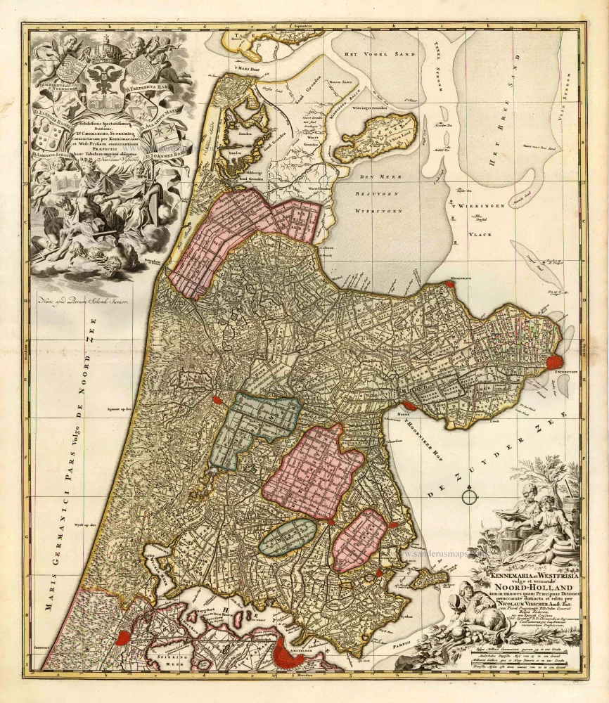
Kennemaria et Westfrisia vulgo et vernaculé Noord-Holland. c. 1700
Noord Holland by Nicolaas Visscher I, published by Petrus Schenk.
[Item number: 25707]

Rhenolandia, Amstelandia et Circumjacentia aliquot Territoria, cum Aggeribus omnibus, Terminiqz fuis. c. 1740
Central Holland by Nicolaas Visscher II, published by Petrus Schenk.
[Item number: 25722]

Leyda, Batavorum Lugdunum, vulgo Leyden, ... 1612
Leiden by Braun and Hogenberg, with Valkenburg, Voorschoten, Zoeterwoude, Leiderdorp ...
[Item number: 30546]

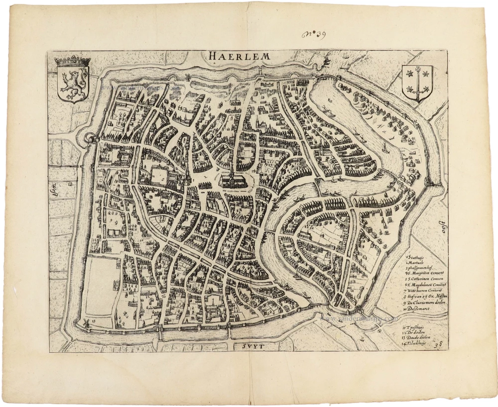
Haerlem 1625
Haarlem by Guicciardini Lodovico
[Item number: 31795]
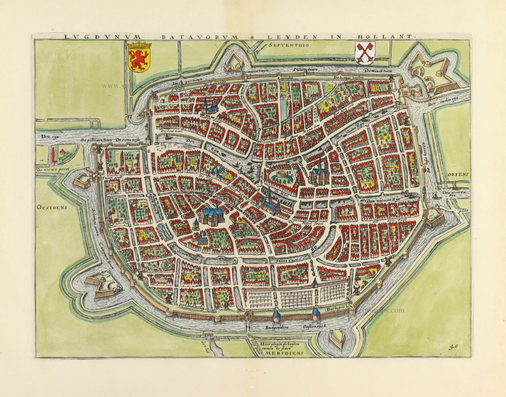
Lugdunum Batavorum - Leyden in Hollant. 1609
Leiden by Guicciardini Lodovico
[Item number: 31796]

Amstelredam 1612
Amsterdam by Guicciardini Lodovico.
[Item number: 31798]
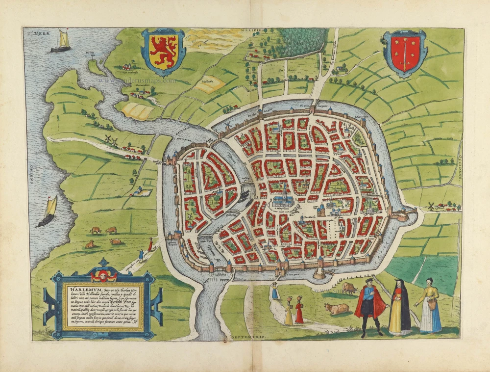
Harlemum, Sive ut Ha: Barlan Herlemum, Urbs Hollandiae famosa, ... 1576
Haarlem, by Georg Braun and Franz Hogenberg.
[Item number: 31817]
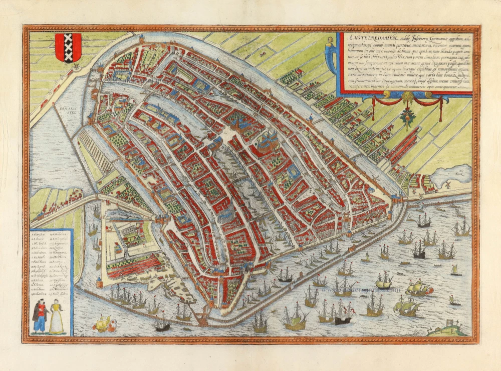
Amstelredamum, Nobile Inferioris Germaniae Oppidum ... 1599
Amsterdam, by Georg Braun & Frans Hogenberg.
[Item number: 31876]

Fosse des Seigneurs de la rue de miroirs vers le fosse de Leyde, de Amsterdam. - Der Herren Graben von der Spiegel Straß sehent nach dem Leidischen Graben zu Amsterdam. c. 1750
Optical View of Amsterdam, by Martin Engelbrecht.
[Item number: 31895]
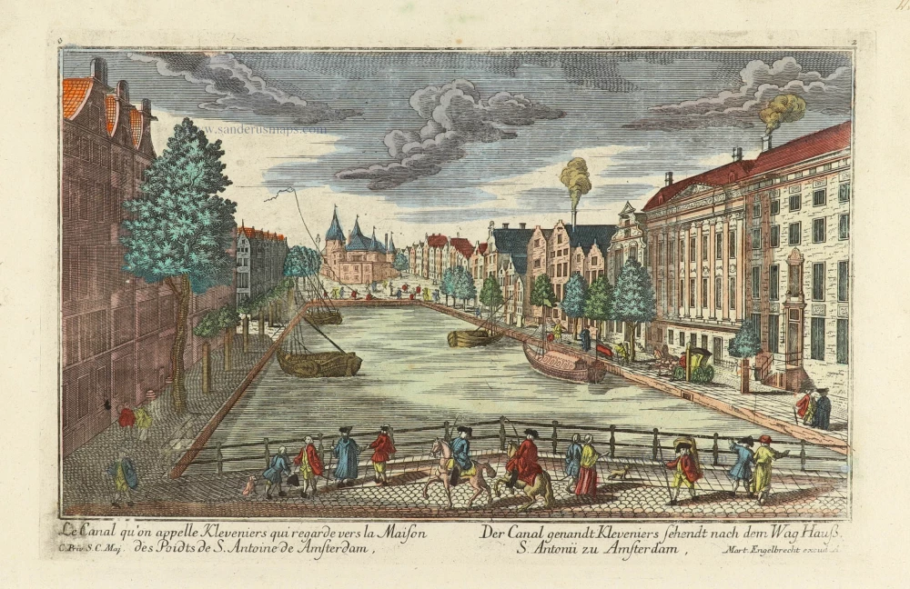
Le Canal qu'on appelle Kleveniers qui regarde vers la Maison des Poidts de S. Antoine de Amsterdam. - Der Canal genandt Kleveniers sehendt nach dem Wag Hauß S. Antonii zu Amsterdam. c. 1750
Optical View of Amsterdam, by Martin Engelbrecht.
[Item number: 31896]
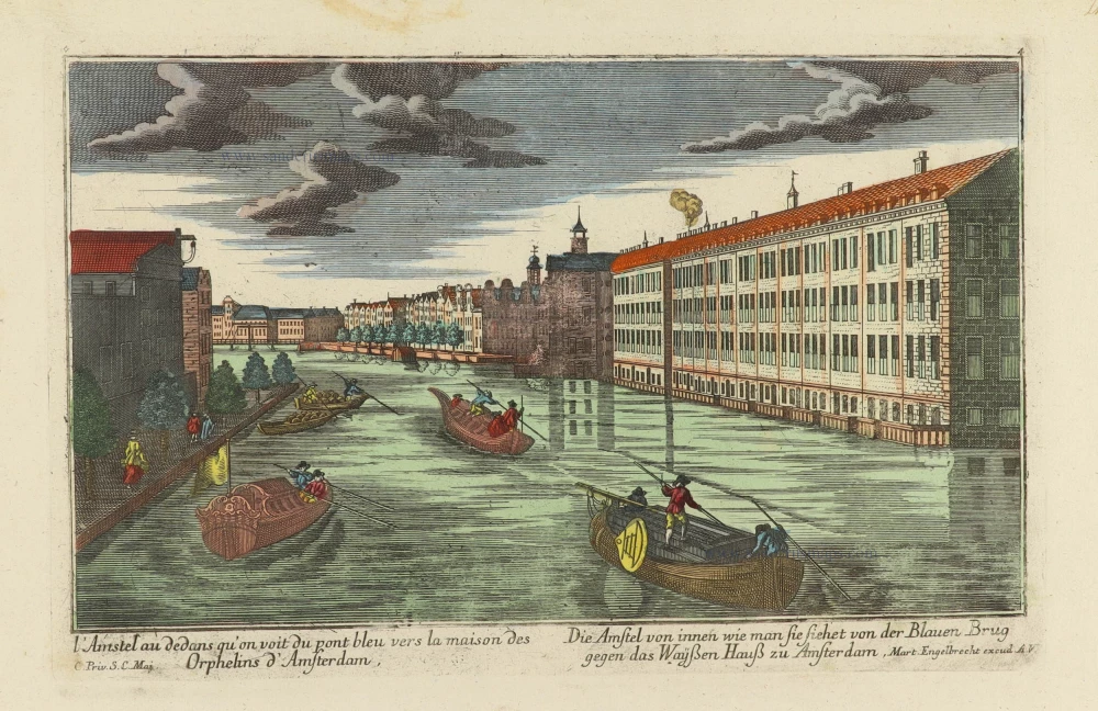
l'Amstel au dedans qu'on voit du pont bleu vers la maison des Orphelins d'Amsterdam. - Die Amstel von innen wie man sie siehet von der Blauen Brug gegen das Wayßen Hauß zu Amsterdam. c. 1750
Optical View of Amsterdam, by Martin Engelbrecht.
[Item number: 31898]

Le Binnekant de Lisle Neufie, et veue de la Tour de Mont Albaan d'Amsterdam. - Die Binnenkant der Neuen Insul, und Gesicht des Mont Alban Thurns zu Amsterdam. c. 1750
Optical View of Amsterdam, by Martin Engelbrecht.
[Item number: 31899]
Optical View
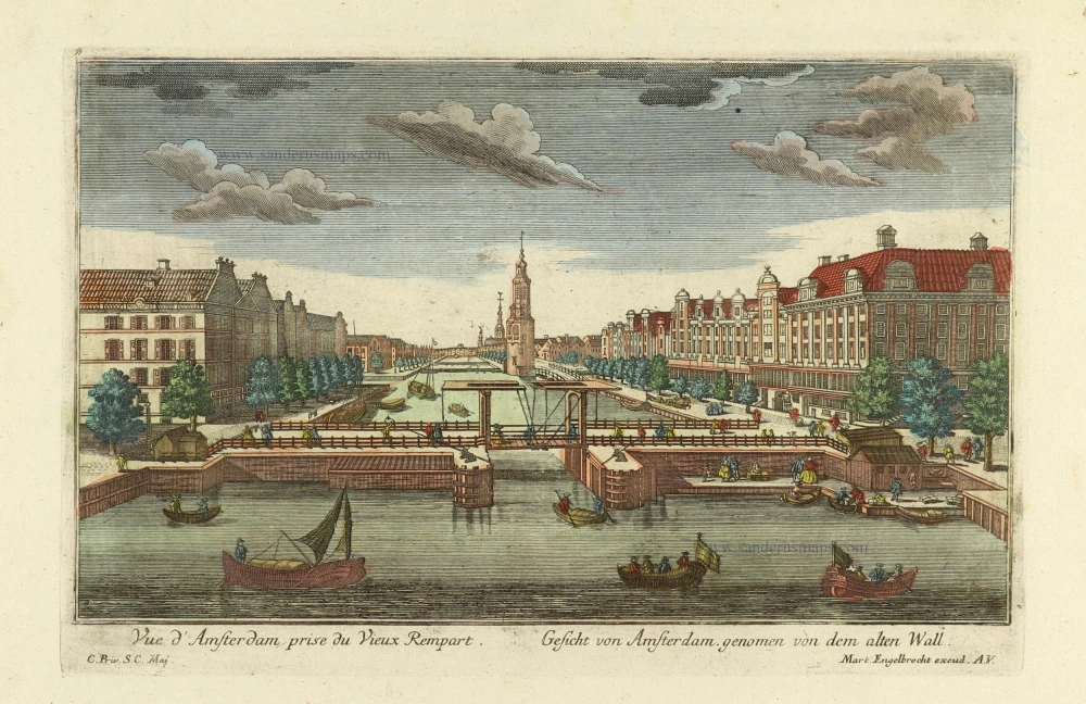
Vue d'Amsterdam prise du Vieux Rempart. - Gesicht von Amsterdam genomen von dem alten Wall. c. 1750
Amsterdam, by Martin Engelbrecht.
[Item number: 31900]

Optical View
L'Amstel par dedans regardant du pont-bleu l'Ecluse d'Amstel a Amsterdam. - Die Amstel von in[n]en nach der Blauen Bruck gegen der Waßer Schleuße zu Amsterdam. c. 1750
Amsterdam, by Martin Engelbrecht.
[Item number: 31902]

t'Stad Huys van Amsteldam. - La Casa Consigliaria d'Amsterdamo. c. 1750
Optical View of Amsterdam, by Martin Engelbrecht.
[Item number: 31903]

Spectacular and rare plan!
Amstelodami Veteris et Novissimi delineatio per Jacobum de la Feuille c. 1710
Amsterdam by Johannes de Ram, published by Jacob de la Feuille and Gerard van Keulen.
[Item number: 32702]

Scarce edition with index
Amstelredamum. 1581
Amsterdam, by Lodovico Guicciardini.
[Item number: 32713]
Haerlem. 1612
Haarlem, by Ludovicus Guicciardini.
[Item number: 32951]

Lugdunum Batavorum * Leyden in Hollant. 1612
Leiden, by Ludovicus Guicciardini.
[Item number: 32952]
Leyden 1686
Leiden by Christoph Riegel.
[Item number: 33100]
new