
Spectacular and rare plan!
Amsterdam by Johannes de Ram, published by Jacob de la Feuille and Gerard van Keulen. c. 1710

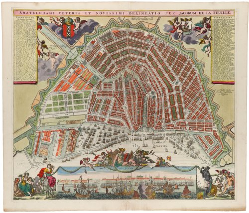
Variant of the rare map described by Koeman IV, d'Ailly #220, and Hameleers #79: the imprint has been shortened, without the text 'en nu te Bekomen 't Amsterdam bij'.
Engraver and publisher Johannes de Ram regularly copied work by others. For the map image, he took a 15-year-old map by Nicolaes Visscher as an example. He copied the city panorama, the decorations in the bottom left and right corners and the idea of the imperial crown (on the city coat of arms) and city seal from a map by rival Frederick de Wit. De Ram added a pair of putti himself.
After the death of Johannes de Ram in 1693, Jacob de la Feuille, who himself continued the business until his death in 1719, married De Ram's widow. He reissued the map, replacing De Ram's name in the title strip for his own. Finally, the map came into the hands of yet another publisher, Gerard van Keulen, who marked it again around 1710.
De la Feuille Jacob (1668-1719)
Watchmaker, engraver and publisher. Son of Daniel. Married the widow of publisher and printer Johannes de Ram in 1696, thereby taking charge of what remained of the Blaeu company and its stock.
Johannes de Ram (1648-1693)
Johannes de Ram was an Amsterdam engraver, publisher, globe maker, and art dealer. He issued atlases with maps by various geographers and produced some maps himself. De Ram seems to have played a particular role in transferring copperplates originating from the Blaeu's.
The House of Van Keulen
For more than two centuries, the chart makers firm of Van Keulen was established in the house with the name of “De Gekroonde Lootsman” (The Crowned Pilot). In 1678, the founder of the firm, Johannes I Van Keulen (1634-1689), registered with the Amsterdam booksellers’ guild. He had enlisted the aid of the well-known Mathematical Practitioner Claas Janz Vooght in the preparation of his nautical publications. In 1680 he published the first edition of the Zee-Atlas with 40 charts, all issued for the first time. In the short period of four years, they produced the five volumes of the Nieuwe Groote Ligtende Zee-Fakkel (1681-85). His acquisition of the stock of the bookseller Hendrik Doncker was an essential factor in the development of the firm.
In 1678 a son, Gerard Van Keulen (1678-1726), was born out of Johannes’s first marriage. This son was endowed with talent. He was a skilful engraver and proficient in mathematics and navigational science. Gerard was responsible for establishing the scientific basis of the firm of Van Keulen. In 1714 he was appointed to the office of hydrographer to the Dutch East India Company. The Van Keulens remained chart makers to the East India Company until the Company’s liquidation.
With the introductions to the Zee-Fakkel and Zee-Atlas, Gerard van Keulen gave a new impetus to the firm. Unfortunately, he did not live long, dying when he was 49. The business was carried on by his widow Ludwina Konst. Shortly before Gerard’s death, his son Johannes II had entered the bookseller’s guild, and in 1726 he assumed the management of the firm, though his mother retained her financial interests in the business.
Johannes II Van Keulen (1704-1755) is known in particular for his publication in 1753 of a sixth volume of the Zee-Fakkel, the volume containing the charts of the route to the East Indies.
Johannes II had two sons; they joined the firm as partners in 1757. A considerable number of books appeared in the period 1778-1801. New issues of the Zee-Fakkel again saw the light. The firm flourished under different names until 1885.
Amstelodami Veteris et Novissimi delineatio per Jacobum de la Feuille
Item Number: 32702 Authenticity Guarantee
Category: Antique maps > Europe > The Netherlands - Cities
City plan and view of Amsterdam, by Johannes de Ram, published by Jacob de la Feuille and Gerard van Keulen.
Title: Amstelodami Veteris et Novissimi delineatio per Jacobum de la Feuille
G. van Keulen Excudit cum Privilegio Ordin. Hollandiae et Westfriesiae.
Cartographer: Johannes de Ram.
Date: c. 1710.
Copper engraving, printed on paper.
Image size: 490 x 570mm (19¼ x 22½ inches).
Sheet size: 540 x 625mm (21¼ x 24½ inches).
Verso: Blank.
Condition: Original coloured, some creases flattened at lower centre.
Condition Rating: A.
Separate publication.
Variant of the rare map described by Koeman IV, d'Ailly #220, and Hameleers #79: the imprint has been shortened, without the text 'en nu te Bekomen 't Amsterdam bij'.
Engraver and publisher Johannes de Ram regularly copied work by others. For the map image, he took a 15-year-old map by Nicolaes Visscher as an example. He copied the city panorama, the decorations in the bottom left and right corners and the idea of the imperial crown (on the city coat of arms) and city seal from a map by rival Frederick de Wit. De Ram added a pair of putti himself.
After the death of Johannes de Ram in 1693, Jacob de la Feuille, who himself continued the business until his death in 1719, married De Ram's widow. He reissued the map, replacing De Ram's name in the title strip for his own. Finally, the map came into the hands of yet another publisher, Gerard van Keulen, who marked it again around 1710.
De la Feuille Jacob (1668-1719)
Watchmaker, engraver and publisher. Son of Daniel. Married the widow of publisher and printer Johannes de Ram in 1696, thereby taking charge of what remained of the Blaeu company and its stock.
Johannes de Ram (1648-1693)
Johannes de Ram was an Amsterdam engraver, publisher, globe maker, and art dealer. He issued atlases with maps by various geographers and produced some maps himself. De Ram seems to have played a particular role in transferring copperplates originating from the Blaeu's.
The House of Van Keulen
For more than two centuries, the chart makers firm of Van Keulen was established in the house with the name of “De Gekroonde Lootsman” (The Crowned Pilot). In 1678, the founder of the firm, Johannes I Van Keulen (1634-1689), registered with the Amsterdam booksellers’ guild. He had enlisted the aid of the well-known Mathematical Practitioner Claas Janz Vooght in the preparation of his nautical publications. In 1680 he published the first edition of the Zee-Atlas with 40 charts, all issued for the first time. In the short period of four years, they produced the five volumes of the Nieuwe Groote Ligtende Zee-Fakkel (1681-85). His acquisition of the stock of the bookseller Hendrik Doncker was an essential factor in the development of the firm.
In 1678 a son, Gerard Van Keulen (1678-1726), was born out of Johannes’s first marriage. This son was endowed with talent. He was a skilful engraver and proficient in mathematics and navigational science. Gerard was responsible for establishing the scientific basis of the firm of Van Keulen. In 1714 he was appointed to the office of hydrographer to the Dutch East India Company. The Van Keulens remained chart makers to the East India Company until the Company’s liquidation.
With the introductions to the Zee-Fakkel and Zee-Atlas, Gerard van Keulen gave a new impetus to the firm. Unfortunately, he did not live long, dying when he was 49. The business was carried on by his widow Ludwina Konst. Shortly before Gerard’s death, his son Johannes II had entered the bookseller’s guild, and in 1726 he assumed the management of the firm, though his mother retained her financial interests in the business.
Johannes II Van Keulen (1704-1755) is known in particular for his publication in 1753 of a sixth volume of the Zee-Fakkel, the volume containing the charts of the route to the East Indies.
Johannes II had two sons; they joined the firm as partners in 1757. A considerable number of books appeared in the period 1778-1801. New issues of the Zee-Fakkel again saw the light. The firm flourished under different names until 1885.
Related items

Amsterdam. 1638
Amsterdam, by M. Merian.
[Item number: 25887]
La Ville de Roterdam. [sic = Amsterdam] 1552
Amsterdam by Sebastian Münster.
[Item number: 28225]

Amsterdam Ville du Comté de Hollande et la plus considerable des Provinces Unies. c. 1780
Amsterdam by Pierre Aveline, published in Paris by Jean.
[Item number: 28778]

Scarce map
Afbeeldinge van zeker concept tot bedykinge van de Haarlemer, Leydse en andere byleggende Meeren. c. 1750
Polder map of Holland, by Nicolaas Visscher, published by Petrus Schenk Jr.
[Item number: 28918]
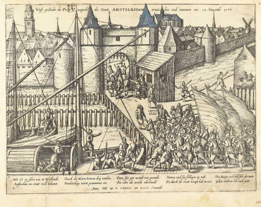
Attack on Amsterdam, 1577: the Haarlemmer gate occupied.
Waß gestalt die Prinsigsche die Statt Amstelredam erwischen und innemen am 23. Novemb: 1577. 1583-1612
Amsterdam Frans Hogenberg
[Item number: 30596]

Scarce
Amsterdam. 1686
Amsterdam by Christoph Riegel.
[Item number: 31501]

Amstelredam 1612
Amsterdam by Guicciardini Lodovico.
[Item number: 31798]
Amstelredamum, Nobile Inferioris Germaniae Oppidum ... 1599
Amsterdam, by Georg Braun & Frans Hogenberg.
[Item number: 31876]

Parte Occidentale dell' Elvezia Divisa ne' suoi Cantoni [and] Parte Orientale dell' Elvezia 1779-1785
Switzerland in two maps, by Antonio Zatta.
[Item number: 31894]

Fosse des Seigneurs de la rue de miroirs vers le fosse de Leyde, de Amsterdam. - Der Herren Graben von der Spiegel Straß sehent nach dem Leidischen Graben zu Amsterdam. c. 1750
Optical View of Amsterdam, by Martin Engelbrecht.
[Item number: 31895]
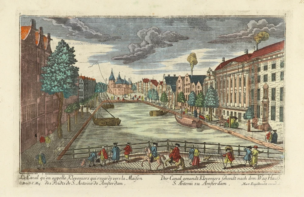
Le Canal qu'on appelle Kleveniers qui regarde vers la Maison des Poidts de S. Antoine de Amsterdam. - Der Canal genandt Kleveniers sehendt nach dem Wag Hauß S. Antonii zu Amsterdam. c. 1750
Optical View of Amsterdam, by Martin Engelbrecht.
[Item number: 31896]

Le Binnekant de Lisle Neufie, et veue de la Tour de Mont Albaan d'Amsterdam. - Die Binnenkant der Neuen Insul, und Gesicht des Mont Alban Thurns zu Amsterdam. c. 1750
Optical View of Amsterdam, by Martin Engelbrecht.
[Item number: 31899]
Optical View
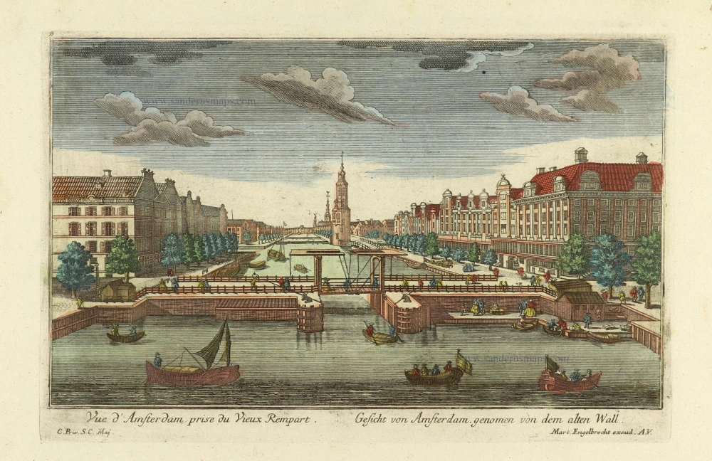
Vue d'Amsterdam prise du Vieux Rempart. - Gesicht von Amsterdam genomen von dem alten Wall. c. 1750
Amsterdam, by Martin Engelbrecht.
[Item number: 31900]

Optical View
L'Amstel par dedans regardant du pont-bleu l'Ecluse d'Amstel a Amsterdam. - Die Amstel von in[n]en nach der Blauen Bruck gegen der Waßer Schleuße zu Amsterdam. c. 1750
Amsterdam, by Martin Engelbrecht.
[Item number: 31902]

t'Stad Huys van Amsteldam. - La Casa Consigliaria d'Amsterdamo. c. 1750
Optical View of Amsterdam, by Martin Engelbrecht.
[Item number: 31903]

Scarce edition with index
Amstelredamum. 1581
Amsterdam, by Lodovico Guicciardini.
[Item number: 32713]