
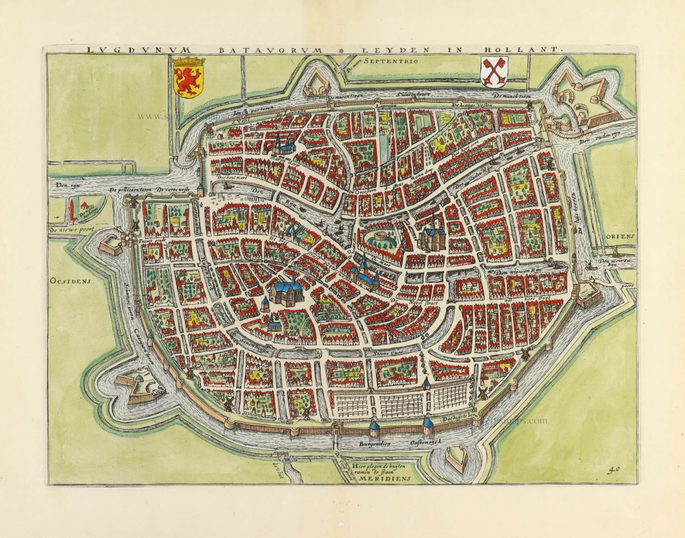
Leiden by Braun and Hogenberg, with Valkenburg, Voorschoten, Zoeterwoude, Leiderdorp ... 1612


TRANSLATION OF CARTOUCHE TEXT: Leiden, the Lugdunum of the Batavi, in the vernacular Leyden. A town that is beautiful and splendid due to its elegant houses and large population, bravely withstood a siege and was surrounded by the Spanish. However, it was not conquered, but relieved through the heroic supply of provisions by the Orange party in the year of salvation 1574, a testament to its resilience and strength.
COMMENTARY BY BRAUN: "In Leiden, there exists a lively trade in wool and cloth, but also in hides and excellent parchment, which are treated and produced here. The city is three miles from Delft and not far from the old Britannic castle, which can still be seen today when the sea recedes a little."
The unusual bird's-eye view from the south shows Leiden with its orderly canals and the surrounding countryside with the villages of Voorchoten (left), Leiderdorp (right) and Zoeterwoude (bottom right). Leiden flourished in the 16th and 17th centuries, experiencing an economic and political upturn. After an unsuccessful five-month siege (the fighting can be seen in the lower right-hand corner), the Spanish withdrew in the autumn of 1574. As a reward, William of Orange founded the university in 1575. The cloth trade boomed, and at the beginning of the 17th century, Leiden had 100,000 inhabitants, a testament to its prosperity and growth.
This map was made by the Dutch cartographer Jan van Liefrinck, who was active in Leiden in 1567 and died there in 1599. He received payment on 22 August 1580 from the Leiden Magistracy for his map and view of the city, destined for Plantijn's edition of Guicciardini's Descrittione, 1581.
Braun G. & Hogenberg F. and the Civitates Orbis Terrarum.
The Civitates Orbis Terrarum, also known as the 'Braun & Hogenberg', is a six-volume town atlas and the most excellent book of town views and plans ever published: 363 engravings, sometimes beautifully coloured. It was one of the best-selling works in the last quarter of the 16th century. Georg Braun, a skilled writer, wrote the text accompanying the plans and views on the verso. Many plates were engraved after the original drawings of a professional artist, Joris Hoefnagel (1542-1600). The first volume was published in Latin in 1572 and the sixth in 1617. Frans Hogenberg, a talented engraver, created the tables for volumes I through IV, and Simon van den Neuwel made those for volumes V and VI. Other contributors were cartographers Daniel Freese and Heinrich Rantzau, who provided valuable geographical information. Works by Jacob van Deventer, Sebastian Münster, and Johannes Stumpf were also used as references. Translations appeared in German and French, making the atlas accessible to a broader audience.
Since its original publication of volume 1 in 1572, the Civitates Orbis Terrarum has left an indelible mark on the history of cartography. Seven more editions followed the first volume in 1575, 1577, 1582, 1588, 1593, 1599, and 1612. Vol.2, initially released in 1575, saw subsequent editions in 1597 and 1612. The subsequent volumes, each a treasure trove of historical insights, graced the world in 1581, 1588, 1593, 1599, and 1606. The German translation of the first volume, a testament to its widespread appeal, debuted in 1574, followed by the French edition in 1575.
Several printers were involved: Theodor Graminaeus, Heinrich von Aich, Gottfried von Kempen, Johannis Sinniger, Bertram Buchholtz, and Peter von Brachel, all of whom worked in Cologne.
Georg Braun (1541-1622)
Georg Braun, the author of the text accompanying the plans and views in the Civitates Orbis Terrarum, was born in Cologne in 1541. After his studies in Cologne, he entered the Jesuit Order as a novice, indicating his commitment to learning and intellectual pursuits. In 1561, he obtained his bachelor's degree; in 1562, he received his Magister Artium, further demonstrating his academic achievements. Although he left the Jesuit Order, he continued his studies in theology, gaining a licentiate in theology. His theological background likely influenced the content and tone of the text in the Civitates Orbis Terrarum, adding a unique perspective to the work.
Frans Hogenberg (1535-1590)
Frans Hogenberg was a Flemish and German painter, engraver, and mapmaker. He was born in Mechelen as the son of Nicolaas Hogenberg.
By the end of the 1560s, Frans Hogenberg was employed upon Abraham Ortelius's Theatrum Orbis Terrarum, published in 1570; he is named an engraver of numerous maps. In 1568, he was banned from Antwerp by the Duke of Alva and travelled to London, where he stayed a few years before emigrating to Cologne. He immediately embarked on his two most important works, the Civitates, published in 1572 and the Geschichtsblätter, which appeared in several series from 1569 until about 1587.
Thanks to large-scale projects like the Geschichtsblätter and the Civitates, Hogenberg's social circumstances improved with each passing year. He died as a wealthy man in Cologne in 1590.
Leyda, Batavorum Lugdunum, vulgo Leyden, ...
Item Number: 30546 Authenticity Guarantee
Category: Antique maps > Europe > The Netherlands - Cities
Bird's-eye view plan of Leiden and surrounds by Braun and Hogenberg, with Valkenburg, Voorschoten, Zoeterwoude, Leiderdorp ...
Title: Leyda, Batavorum Lugdunum, vulgo Leyden, ...
Concinna edificiorum et incolarum frequetia pulcherrimum nitidißimumq, opp. ab Hispanis obsidione cinctum, ab Auriacis eutem comeatus invectione liberatum Anno parte salutis M D LXXIIII.
Date of the first edition: 1575.
Date of this map: 1612.
Copper engraving, printed on paper.
Image size: 340 x 473mm (13.39 x 18.62 inches).
Sheet size: 415 x 535mm (16.34 x 21.06 inches).
Verso: Latin text.
Condition: Original coloured, excellent.
Condition Rating: A+.
From: Civitates Orbis Terrarum. De Praecipuis, Totius Universi Urbibus. Liber Secundus. Cologne, Petrus von Brachel, 1612.
TRANSLATION OF CARTOUCHE TEXT: Leiden, the Lugdunum of the Batavi, in the vernacular Leyden. A town that is beautiful and splendid due to its elegant houses and large population, bravely withstood a siege and was surrounded by the Spanish. However, it was not conquered, but relieved through the heroic supply of provisions by the Orange party in the year of salvation 1574, a testament to its resilience and strength.
COMMENTARY BY BRAUN: "In Leiden, there exists a lively trade in wool and cloth, but also in hides and excellent parchment, which are treated and produced here. The city is three miles from Delft and not far from the old Britannic castle, which can still be seen today when the sea recedes a little."
The unusual bird's-eye view from the south shows Leiden with its orderly canals and the surrounding countryside with the villages of Voorchoten (left), Leiderdorp (right) and Zoeterwoude (bottom right). Leiden flourished in the 16th and 17th centuries, experiencing an economic and political upturn. After an unsuccessful five-month siege (the fighting can be seen in the lower right-hand corner), the Spanish withdrew in the autumn of 1574. As a reward, William of Orange founded the university in 1575. The cloth trade boomed, and at the beginning of the 17th century, Leiden had 100,000 inhabitants, a testament to its prosperity and growth.
This map was made by the Dutch cartographer Jan van Liefrinck, who was active in Leiden in 1567 and died there in 1599. He received payment on 22 August 1580 from the Leiden Magistracy for his map and view of the city, destined for Plantijn's edition of Guicciardini's Descrittione, 1581.
Braun G. & Hogenberg F. and the Civitates Orbis Terrarum.
The Civitates Orbis Terrarum, also known as the 'Braun & Hogenberg', is a six-volume town atlas and the most excellent book of town views and plans ever published: 363 engravings, sometimes beautifully coloured. It was one of the best-selling works in the last quarter of the 16th century. Georg Braun, a skilled writer, wrote the text accompanying the plans and views on the verso. Many plates were engraved after the original drawings of a professional artist, Joris Hoefnagel (1542-1600). The first volume was published in Latin in 1572 and the sixth in 1617. Frans Hogenberg, a talented engraver, created the tables for volumes I through IV, and Simon van den Neuwel made those for volumes V and VI. Other contributors were cartographers Daniel Freese and Heinrich Rantzau, who provided valuable geographical information. Works by Jacob van Deventer, Sebastian Münster, and Johannes Stumpf were also used as references. Translations appeared in German and French, making the atlas accessible to a broader audience.
Since its original publication of volume 1 in 1572, the Civitates Orbis Terrarum has left an indelible mark on the history of cartography. Seven more editions followed the first volume in 1575, 1577, 1582, 1588, 1593, 1599, and 1612. Vol.2, initially released in 1575, saw subsequent editions in 1597 and 1612. The subsequent volumes, each a treasure trove of historical insights, graced the world in 1581, 1588, 1593, 1599, and 1606. The German translation of the first volume, a testament to its widespread appeal, debuted in 1574, followed by the French edition in 1575.
Several printers were involved: Theodor Graminaeus, Heinrich von Aich, Gottfried von Kempen, Johannis Sinniger, Bertram Buchholtz, and Peter von Brachel, all of whom worked in Cologne.
Georg Braun (1541-1622)
Georg Braun, the author of the text accompanying the plans and views in the Civitates Orbis Terrarum, was born in Cologne in 1541. After his studies in Cologne, he entered the Jesuit Order as a novice, indicating his commitment to learning and intellectual pursuits. In 1561, he obtained his bachelor's degree; in 1562, he received his Magister Artium, further demonstrating his academic achievements. Although he left the Jesuit Order, he continued his studies in theology, gaining a licentiate in theology. His theological background likely influenced the content and tone of the text in the Civitates Orbis Terrarum, adding a unique perspective to the work.
Frans Hogenberg (1535-1590)
Frans Hogenberg was a Flemish and German painter, engraver, and mapmaker. He was born in Mechelen as the son of Nicolaas Hogenberg.
By the end of the 1560s, Frans Hogenberg was employed upon Abraham Ortelius's Theatrum Orbis Terrarum, published in 1570; he is named an engraver of numerous maps. In 1568, he was banned from Antwerp by the Duke of Alva and travelled to London, where he stayed a few years before emigrating to Cologne. He immediately embarked on his two most important works, the Civitates, published in 1572 and the Geschichtsblätter, which appeared in several series from 1569 until about 1587.
Thanks to large-scale projects like the Geschichtsblätter and the Civitates, Hogenberg's social circumstances improved with each passing year. He died as a wealthy man in Cologne in 1590.
Related items

Scarce map
Afbeeldinge van zeker concept tot bedykinge van de Haarlemer, Leydse en andere byleggende Meeren. c. 1750
Polder map of Holland, by Nicolaas Visscher, published by Petrus Schenk Jr.
[Item number: 28918]
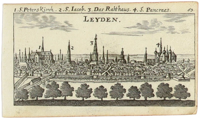
Lugdunum Batavorum - Leyden in Hollant. 1609
Leiden by Guicciardini Lodovico
[Item number: 31796]

Lugdunum Batavorum * Leyden in Hollant. 1612
Leiden, by Ludovicus Guicciardini.
[Item number: 32952]
Leyden 1686
Leiden by Christoph Riegel.
[Item number: 33100]
new