
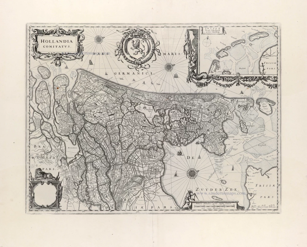
Holland by C. Tassin. 1633

Tassin Christophe Nicolas. (? - 1660)
Christophe Tassin was a French cartographer known for his atlases of France, Spain, Germany, and Switzerland.
He was 'Ingenieur-géographe du roi'. He used this title only between 1633 and 1638. In 1633 Tassin published an atlas of France and Spain, Cartes générales des provinces de France et d’ Espagne; one of Germany, Cartes généralis des royaumes et provinces de la haute et basse Allemagna; and one of the Low Countries, Plans et profils des principales villes du duché de Lorraine, avec les cartes generale et particulieres de chacun gouvernement d’iucelles.
In 1644, Tassin ended his work and sold his copper plates of maps to Antoine de Fer, who published them in many subsequent editions.
Carte de Hollande.
Item Number: 31762 Authenticity Guarantee
Category: Antique maps > Europe > The Netherlands
Holland by C. Tassin.
Title: Carte de Hollande.
Date of the first edition: 1633.
Date of this map: 1633.
Copper engraving, printed on paper.
Image size: 105 x 150mm (4¼ x 6 inches).
Sheet size: 155 x 195mm (6 x 7¾ inches).
Verso: Blank.
Condition: Excellent.
Condition Rating: A+.
From: Tassin C. Cartes Generales des Royaumes et Provinces de la Haute et Basse Allemagne. Reveues, corrigées & augmentées par le sieur Tassin Geographe ordinaire de sa Majesté. A Paris, Chez Martin Gobert au Palais en la gallerie des prisonniers. M.DC.XXXIII. (1633). (Pastoureau, p. 445, Tassin IV Aa 1633)
Tassin Christophe Nicolas. (? - 1660)
Christophe Tassin was a French cartographer known for his atlases of France, Spain, Germany, and Switzerland.
He was 'Ingenieur-géographe du roi'. He used this title only between 1633 and 1638. In 1633 Tassin published an atlas of France and Spain, Cartes générales des provinces de France et d’ Espagne; one of Germany, Cartes généralis des royaumes et provinces de la haute et basse Allemagna; and one of the Low Countries, Plans et profils des principales villes du duché de Lorraine, avec les cartes generale et particulieres de chacun gouvernement d’iucelles.
In 1644, Tassin ended his work and sold his copper plates of maps to Antoine de Fer, who published them in many subsequent editions.
Related items

Rare and important map!
Hollandiae Batavor Veteris Insulae Locorum Adiacentium Exacta Descriptio. 1563
Holland, by Camocio G.F. - Forlani P.
[Item number: 9232]

De Cust van Hollandt Tusschen de Maes en Texel. 1686
Holland by Hendrick Doncker.
[Item number: 15677]

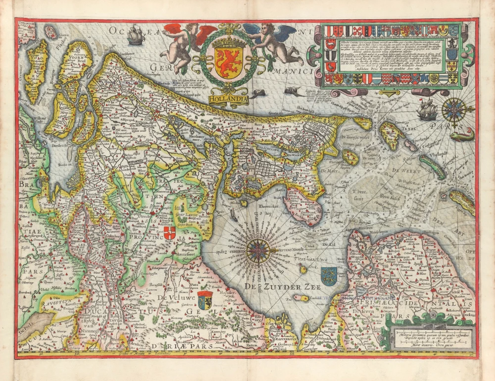
Comitatus Hollandiae novissima descriptio. 1638
Holland, by Janssonius J.
[Item number: 19020]

Cust van Hollant tusschen de Maes ende Texel 1667
Sea chart of Holland, by Pieter Goos.
[Item number: 19040]

Kaart van 't Graafschap Holland Naauwkeurig Afgedeelt in zyne Heemraadschappen, Baljuwschappen en Waarden, 1730-45
Holland by C. Specht, published by R. & J. Ottens.
[Item number: 25706]

La Hollande. 1713
Holland by Pieter Van der Aa.
[Item number: 26059]

Hollandiae Cattorum Regionis Typus. 1588
Holland, by Lodovico Guicciardini.
[Item number: 26656]

Second printed Holland map.
Hola(n)d. 1552
Holland by Sebastian Münster.
[Item number: 27467]

Big and spectacular map
Le Comté de Hollande. c. 1705
Holland, by Pieter Mortier.
[Item number: 27807]

Comitatus Hollandiae Tabula Pluribus Locis Recens Emendata A Frederico De Wit. c. 1705
Holland, by Frederick de Wit.
[Item number: 29011]

Hollandiae Antiquorum Catthorum Sedis Nova Descriptio. 1584
Holland, by Abraham Ortelius.
[Item number: 29547]
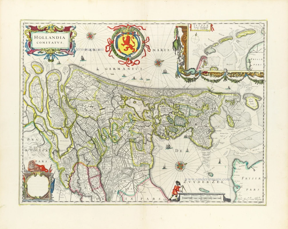
Hollandia Comitatus. 1643
Holland by Willem Blaeu
[Item number: 30182]
Hollandia. 1617
Holland by Petrus Kaerius (Pieter Van den Keere).
[Item number: 30257]

Hollandiae Antiquorum Catthorum Sedis Nova Descriptio. 1603
Holland, by Abraham Ortelius.
[Item number: 31103]
Hollandia Comitatus. 1647
Holland by Willem Blaeu
[Item number: 31104]

Hollandia. 1618
Holland by Petrus Bertius, published by Jodocus Hondius II.
[Item number: 31589]

Le Comté de Hollande Dressé sur les Memoires les plus Nouveaux. 1692
Holland by N. Sanson, so-called published by Hubert Jaillot. (Pirated edition by Pierre Mortier).
[Item number: 31717]

Novißima Tabula Insular. Dordracensis, Alblasser, Crimper, Clundert etc: Comprehens item Territoria Vianae, Goricomii, Leerdami, Altenae, Heusdenae, ac Civitates ... 1638
Holland (Southeast), by Henricus Hondius.
[Item number: 32446]

Comitatus Hollandiae novissima descriptio. 1638
Holland by Henricus Hondius
[Item number: 32448]