
Rare sea chart of the Netherlands.
Willem Blaeu, pirate edition by Joannes Janssonius. 1620-1634


In the history of early Dutch pilot guides, Blaeu's work takes a very prominent place. Lucas Jansz was his famous predecessor for describing the Eastern, Western and Northern navigation. Waghenaer, who published his pilot books from 1584-1608. A work by Albert Haeyen came on the market from 1585-1613. Besides this Willem Barentsz. described the navigation of the Mediterranean; his work was published from 1595-1626.
Blaeu's pilot guide, named Het Licht der Zee-vaert, was published in oblong in all editions known. It was published in Dutch, English and French, except the third part, dealing with the Mediterranean, which was only published in Dutch.
In 1620 Blaeu's competitor Johannes Janssonius ventured to publish Blaeu's work, with plates, precisely copied by Petrus Kaerius. The text was accurately copied as well. Willem Blaeu's Licht der Zee-vaert was privileged in 1606 for seven years. Besides this Blaeu has been granted a privilege for ten years in 1608, for all his works published or to be published. As the first edition of Het Licht der Zee-vaert was dated 1608, the privilege for this book was valid until 1618, so it is quite possible that Blaeu could not do anything to Janssonius.
The Blaeus: Willem Janszoon, Cornelis & Joan
Willem Jansz. Blaeu and his son Joan Blaeu are the seventeenth century's most widely known cartographic publishers.
Willem Jansz. (also written Guilielmus Janssonius) = Willem Janszoon Blaeu was born in Uitgeest (Netherlands), near Alkmaar, in 1571. He studied mathematics under Tycho Brahe and learned the theory and practice of astronomical observations and the art of instrument- and globe-making.
In 1596, he came to Amsterdam, where he settled down as a globe-, instrument- and mapmaker. He published his first cartographic work (a globe) in 1599 and probably published his first printed map (a map of the Netherlands) in 1604. He specialised in maritime cartography, published the first edition of the pilot guide Het Licht der Zeevaert in 1608, and was appointed Hydrographer of the V.O.C. (United East India Company) in 1633. After publishing books, wall maps, globes, charts and pilot guides for thirty years, he brought out his first atlas, Atlas Appendix (1630). This was the beginning of the great tradition of atlas-making by the Blaeus.
In 1618, another mapmaker, bookseller and publisher, Johannes Janssonius, established himself in Amsterdam next door to Blaeu's shop. No wonder these two neighbours began accusing each other of copying and stealing their information and became fierce competitors who did not have a good word to say about each other. In about 1621 Willem Jansz. decided to end the confusion between his name and his competitor's and assumed his grandfather's nickname, 'blauwe Willem' ('blue Willem'), as the family name; after that, he called himself Willem Jansz. Blaeu.
Willem Janszoon Blaeu died in 1638, leaving his prospering business to his sons, Cornelis and Joan. We only know that Cornelis's name occurs in the prefaces of books and atlases until c. 1645.
Joan Blaeu, born in Amsterdam in 1596, became a partner in his father's book trade and printing business. 1638, he was appointed his father's successor in the Hydrographic Office of the V.O.C. His efforts culminated in the magnificent Atlas Major and the town books of the Netherlands and Italy – works unsurpassed in history and modern times, giving eternal fame to the name of the Blaeu's.
A fire ruined the business on February 23, 1672, and one year later, Dr. Joan Blaeu died. The fire and the director's passing caused the complete sale of the Blaeu House's stock. Five public auctions dispersed the remaining books, atlases, copperplates, globes, etc., among many other map dealers and publishers in Amsterdam. The majority was acquired by several booksellers acting in partnership.
In the succeeding years, the remaining printing department remained in the hands of the Blaeu family until 1695, when the printing house's inventory was sold at a public auction. That meant the end of the Blaeu family as a printing house of world renown.
The Janssonius Family
Joannes Janssonius (Arnhem, 1588-1664), son of the Arnhem publisher Jan Janssen, married Elisabeth Hondius, daughter of Jodocus Hondius, in Amsterdam in 1612. After his marriage, he settled down in this town as a bookseller and publisher of cartographic material. In 1618, he established himself in Amsterdam next door to Blaeu’s bookshop. He entered into serious competition with Willem Jansz. Blaeu when copying Blaeu’s Licht der Zeevaert after the expiration of the privilege in 1620. His activities concerned the publication of atlases, books, single maps, and an extensive book trade with branches in Frankfurt, Danzig, Stockholm, Copenhagen, Berlin, Koningsbergen, Geneva, and Lyon. In 1631, he began publishing atlases together with Henricus Hondius.
In the early 1640s, Henricus Hondius left the atlas publishing business to Janssonius. Competition with Joan Blaeu, Willem’s son and successor, in atlas production, prompted Janssonius to enlarge his Atlas Novus finally into a work of six volumes, into which a sea atlas and an atlas of the Old World were inserted. Other atlases published by Janssonius are Mercator’s Atlas Minor, Hornius’s historical atlas (1652), the townbooks in eight volumes (1657), Cellarius’s Atlas Coelestis and several sea atlases and pilot guides.
After the death of Joannes Janssonius, the shop and publishing firm were continued by the heirs under the direction of Johannes van Waesbergen (c. 1616-1681), son-in-law of Joannes Janssonius. Van Waesbergen added Janssonius's name to his own.
In 1676, Joannes Janssonius’s heirs sold by auction “all the remaining Atlases in Latin, French, High and Low German, as well as the Stedeboecken in Latin, in 8 volumes, bound and unbound, maps, plates belonging to the Atlas and Stedeboecken.” The copperplates from Janssonius’s atlases were afterwards sold to Schenk and Valck.
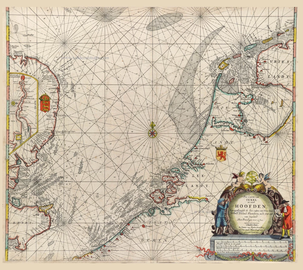
Pascaarte van Hollandt Zeelandt ende Vlaanderen, van Texel af tot deur de Hoofden, toonende de rechte gelegenheijt aller gaten, Zanden, banken, diepten ende de ondiepten daer ontret gelegen. - Carte Marine de Hollande Zeelande et Flandres, ...
Item Number: 30058 Authenticity Guarantee
Category: Antique maps > Europe > Belgium
Old, antique sea chart of the coasts of Holland, Zeeland, and Flanders by Willem Blaeu, pirate edition by Joannes Janssonius.
Title: Pascaarte van Hollandt Zeelandt ende Vlaanderen, van Texel af tot deur de Hoofden, toonende de rechte gelegenheijt aller gaten, Zanden, banken, diepten ende de ondiepten daer ontret gelegen. - Carte Marine de Hollande Zeelande et Flandres, ...
Oriented to the southeast.
Date: 1620-1634.
Copper engraving, printed on paper.
Image size: 245 x 550mm (9.65 x 21.65 inches).
Sheet size: 250 x 555mm (9.84 x 21.85 inches).
Verso: Blank.
Condition: coloured, good condition.
Condition Rating: A.
From: Het Licht der Zee-vaert daerinne claerlijck beschreven end afghebeeldet werde, alle de Custen ende Havenen, vande Westersche, Noordsche, Oostersche ende Middelandsche Zee'n. Oock van vele Landen, Eylanden ende plaetsen van Guinea, Brasilien, Oost ende West-Indien. ... Door Willem Ians Zoon. Ghedruckt bij Jan Janssoon ... Anno 1620. (-1634). (Koeman IV, p. 267-268, M.Bl.15-20) (Pirate editions of Blaeu's Licht der Zee-Vaert, 1608-1620).
In the history of early Dutch pilot guides, Blaeu's work takes a very prominent place. Lucas Jansz was his famous predecessor for describing the Eastern, Western and Northern navigation. Waghenaer, who published his pilot books from 1584-1608. A work by Albert Haeyen came on the market from 1585-1613. Besides this Willem Barentsz. described the navigation of the Mediterranean; his work was published from 1595-1626.
Blaeu's pilot guide, named Het Licht der Zee-vaert, was published in oblong in all editions known. It was published in Dutch, English and French, except the third part, dealing with the Mediterranean, which was only published in Dutch.
In 1620 Blaeu's competitor Johannes Janssonius ventured to publish Blaeu's work, with plates, precisely copied by Petrus Kaerius. The text was accurately copied as well. Willem Blaeu's Licht der Zee-vaert was privileged in 1606 for seven years. Besides this Blaeu has been granted a privilege for ten years in 1608, for all his works published or to be published. As the first edition of Het Licht der Zee-vaert was dated 1608, the privilege for this book was valid until 1618, so it is quite possible that Blaeu could not do anything to Janssonius.
The Blaeus: Willem Janszoon, Cornelis & Joan
Willem Jansz. Blaeu and his son Joan Blaeu are the seventeenth century's most widely known cartographic publishers.
Willem Jansz. (also written Guilielmus Janssonius) = Willem Janszoon Blaeu was born in Uitgeest (Netherlands), near Alkmaar, in 1571. He studied mathematics under Tycho Brahe and learned the theory and practice of astronomical observations and the art of instrument- and globe-making.
In 1596, he came to Amsterdam, where he settled down as a globe-, instrument- and mapmaker. He published his first cartographic work (a globe) in 1599 and probably published his first printed map (a map of the Netherlands) in 1604. He specialised in maritime cartography, published the first edition of the pilot guide Het Licht der Zeevaert in 1608, and was appointed Hydrographer of the V.O.C. (United East India Company) in 1633. After publishing books, wall maps, globes, charts and pilot guides for thirty years, he brought out his first atlas, Atlas Appendix (1630). This was the beginning of the great tradition of atlas-making by the Blaeus.
In 1618, another mapmaker, bookseller and publisher, Johannes Janssonius, established himself in Amsterdam next door to Blaeu's shop. No wonder these two neighbours began accusing each other of copying and stealing their information and became fierce competitors who did not have a good word to say about each other. In about 1621 Willem Jansz. decided to end the confusion between his name and his competitor's and assumed his grandfather's nickname, 'blauwe Willem' ('blue Willem'), as the family name; after that, he called himself Willem Jansz. Blaeu.
Willem Janszoon Blaeu died in 1638, leaving his prospering business to his sons, Cornelis and Joan. We only know that Cornelis's name occurs in the prefaces of books and atlases until c. 1645.
Joan Blaeu, born in Amsterdam in 1596, became a partner in his father's book trade and printing business. 1638, he was appointed his father's successor in the Hydrographic Office of the V.O.C. His efforts culminated in the magnificent Atlas Major and the town books of the Netherlands and Italy – works unsurpassed in history and modern times, giving eternal fame to the name of the Blaeu's.
A fire ruined the business on February 23, 1672, and one year later, Dr. Joan Blaeu died. The fire and the director's passing caused the complete sale of the Blaeu House's stock. Five public auctions dispersed the remaining books, atlases, copperplates, globes, etc., among many other map dealers and publishers in Amsterdam. The majority was acquired by several booksellers acting in partnership.
In the succeeding years, the remaining printing department remained in the hands of the Blaeu family until 1695, when the printing house's inventory was sold at a public auction. That meant the end of the Blaeu family as a printing house of world renown.
The Janssonius Family
Joannes Janssonius (Arnhem, 1588-1664), son of the Arnhem publisher Jan Janssen, married Elisabeth Hondius, daughter of Jodocus Hondius, in Amsterdam in 1612. After his marriage, he settled down in this town as a bookseller and publisher of cartographic material. In 1618, he established himself in Amsterdam next door to Blaeu’s bookshop. He entered into serious competition with Willem Jansz. Blaeu when copying Blaeu’s Licht der Zeevaert after the expiration of the privilege in 1620. His activities concerned the publication of atlases, books, single maps, and an extensive book trade with branches in Frankfurt, Danzig, Stockholm, Copenhagen, Berlin, Koningsbergen, Geneva, and Lyon. In 1631, he began publishing atlases together with Henricus Hondius.
In the early 1640s, Henricus Hondius left the atlas publishing business to Janssonius. Competition with Joan Blaeu, Willem’s son and successor, in atlas production, prompted Janssonius to enlarge his Atlas Novus finally into a work of six volumes, into which a sea atlas and an atlas of the Old World were inserted. Other atlases published by Janssonius are Mercator’s Atlas Minor, Hornius’s historical atlas (1652), the townbooks in eight volumes (1657), Cellarius’s Atlas Coelestis and several sea atlases and pilot guides.
After the death of Joannes Janssonius, the shop and publishing firm were continued by the heirs under the direction of Johannes van Waesbergen (c. 1616-1681), son-in-law of Joannes Janssonius. Van Waesbergen added Janssonius's name to his own.
In 1676, Joannes Janssonius’s heirs sold by auction “all the remaining Atlases in Latin, French, High and Low German, as well as the Stedeboecken in Latin, in 8 volumes, bound and unbound, maps, plates belonging to the Atlas and Stedeboecken.” The copperplates from Janssonius’s atlases were afterwards sold to Schenk and Valck.
Related items

De Cust van Hollandt Tusschen de Maes en Texel. 1686
Holland by Hendrick Doncker.
[Item number: 15677]

Cust van Hollant tusschen de Maes ende Texel 1667
Sea chart of Holland, by Pieter Goos.
[Item number: 19040]

Paskaert van de Zeeusche en Vlaemsche Kusten, tonende Alle Drooghten, Diepten, en Ondiepten, tusschen t'Eylandt Schouwen en de Hoofden, Curieuselyck Beschreven door Dirck Davidsz 1667
Sea chart of Flanders (Vlaanderen) & Zeeland, by Pieter Goos.
[Item number: 19054]

Spectacular 'Romain de Hooghe' map
Carte Nouvelle des Costes de Hollande, Zeelande, Flandre, Picardie, & Normandie ... Chez Pierre Mortier, 1693. 1700
Sea chart of the Channel - Flanders (Vlaanderen) - Zeeland, by Pieter Mortier.
[Item number: 27176]
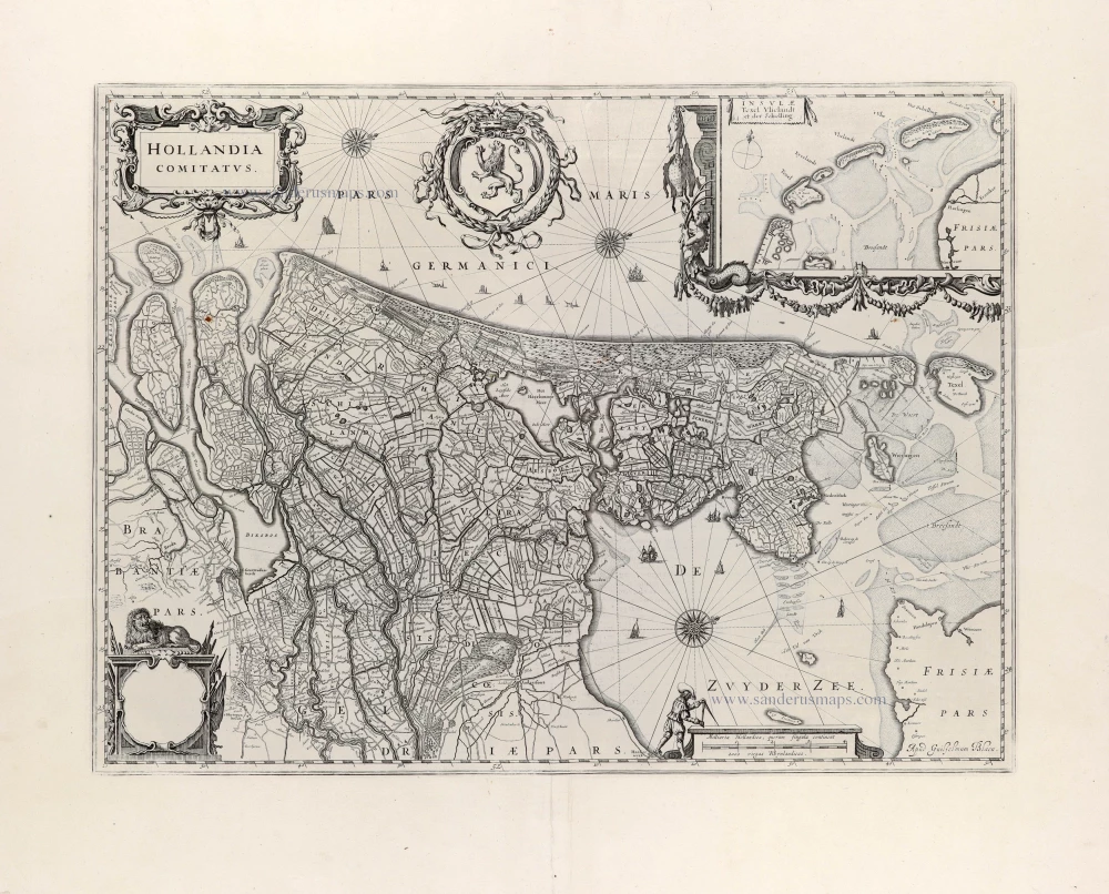
Hollandia Comitatus. 1647
Holland by Willem Blaeu
[Item number: 31104]

RARE
De Cust van Vlaenderen Beginnende vande Wielingen tot aen de Hoofden met alle haer sanden en droogten. 1644
Chart by Anthonie Jacobsz, the Flemish coast.
[Item number: 32608]
Pas Caerte van Texel, tot aende Hoofden; Begrypende in sich de Zee-custen van Vries-land, Holland, Zeeland, Flaenderen; ende Oost-cust van Engeland. 1680-1694
Chart of the Southern North Sea, by Joannes Van Keulen
[Item number: 32628]