Antique maps catalogue
- All recent additions
-
Antique maps
- Polar maps
- World
-
Europe
- Europe Continent
- Belgium
- Belgium - Cities
- The Low Countries
- The Netherlands
- The Netherlands - Cities
- Luxembourg
- France
- France - Cities
- Germany
- Germany - Cities
- Austria
- Italy
- Italy - Cities
- Spain and Portugal
- Greece & Greek Islands
- Switzerland
- British Isles
- British Isles - Cities
- Northern Europe
- Central Europe
- Eastern Europe
- Southeastern Europe
- America
- Asia
- Africa
- Mediterranean Sea
- Australia
- Oceans
- Celestial Maps
- Curiosities
- Title Pages
- Books
- Medieval manuscripts
- Prints
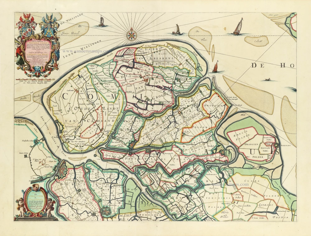
Rare Visscher map of Het Zwin, in a stunning colouring and gold-heightened, all in the style of Dirk Van Santen
Oost-Vrije (West Zeeuws-Vlaanderen), by Nicolaes Visscher. 1656
't Meerderdeel van 't OOST-VRYE in Vlaenderen Vertonende...
[Item number: 32588]
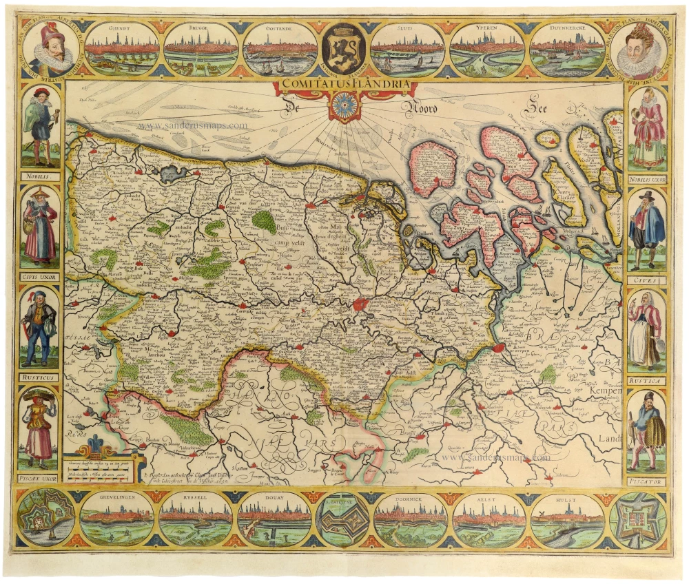
The most beautiful 17th-century map of Flanders, with four decorative borders.
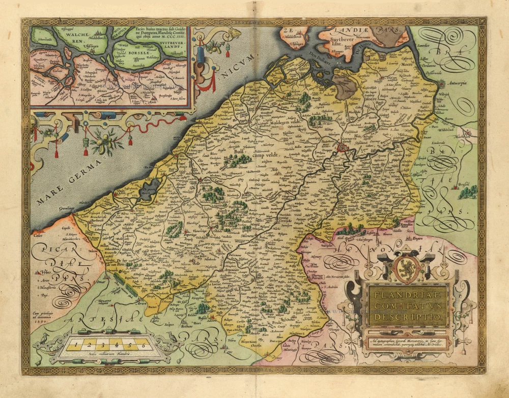
Vlaanderen by C.J. Visscher. 1652
Comitatus Flandriae.
[Item number: 33151]
new

Extremely rare map of Het Zwin (Knokke - Belgium)
Het Zwin - Knokke, Sluis, and Cadzand by Claes Jansz Visscher. 1627-37
Kaerte van Sluys, het Zwin ende de Schansen aen weder Syden.
[Item number: 30256]
![Typus octo longaru[m] naviu[m]. Anno M.VI.c.II ab Hispaniae rege missaru[m] ad Oceanum Belgicum infestandu[m]. quarum naviu[m] quatuor Angloru[m] atq³ Hollandoru[m] virtute conquassatae sunt et submersae: ceterae naufragio periere.](https://sanderusmaps.com/assets/IMG/webp/m26804.webp)
Very important naval print: The first print published by the Blaeu family
Defeat of Spanish galleys by an Anglo-Dutch naval force off the coast of Flanders, 3-4 Oct. 1602. by Willem Blaeu c. 1602
Typus octo longaru[m] naviu[m]. Anno M.VI.c.II ab Hispaniae rege...
[Item number: 26804]

Rare.
Brugse Vrije by C.J. Visscher, published by Petrus Kaerius (Pieter van den Keere). 1622
Caerte van T'Vrye sijnde een Gedeelte en Lidt van Vlaenderen....
[Item number: 28454]

Famous and beautiful map
Ypres (Ieper) Castellania, by Sanderus A. 1732
Nova et Exacta Tabula Geographica Salae et Castellaniae Iprensis...
[Item number: 27434]
Rare!
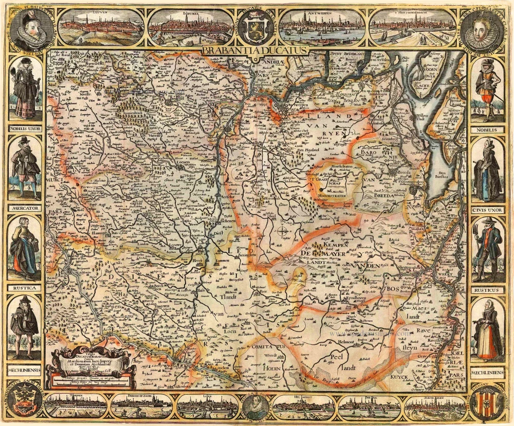
Brabant by Pieter Verbiest 1628
Brabantia Ducatus / Tabula Ducatus Brabantiae Continens...
[Item number: 27743]
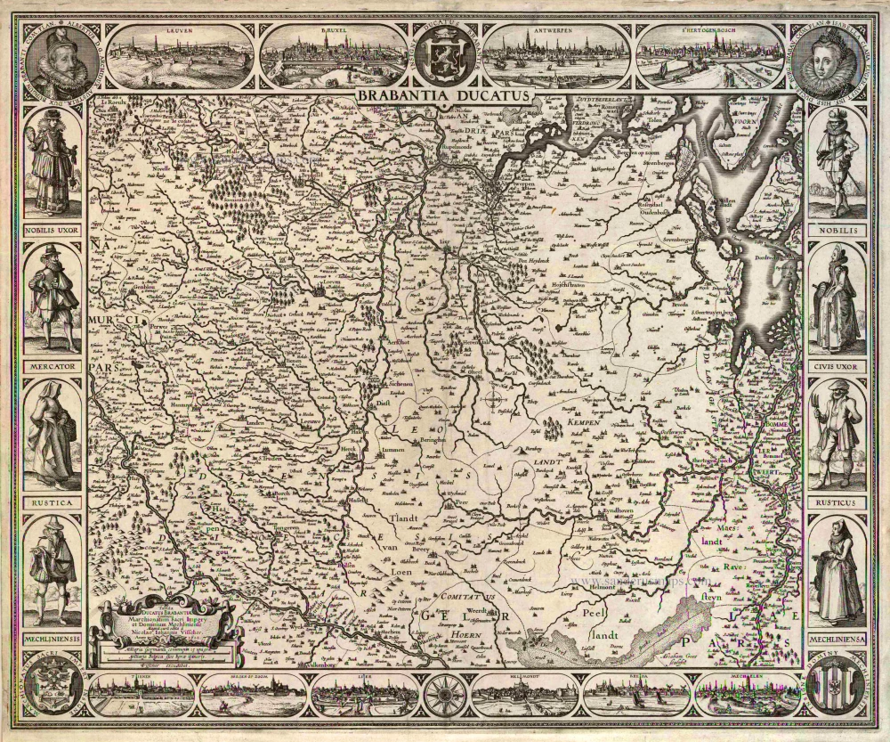
Brabant by C.J. Visscher. 1622
Brabantia Ducatus / Tabula Ducatus Brabantiae Continens...
[Item number: 2640]

Mechelen - Antwerpen, by Covens & Mortier. 1721-41
Marchionatus Sacri Imperiit Dominii Mechelini Tabula
[Item number: 23690]

Antwerp (Antwerpen), by Petrus Kaerius. 1617
Marchionatus Sacri Romani Imperii.
[Item number: 32003]

One of Antwerp's most beautiful maps
Antwerp, by Nicolaes Visscher I, published by Petrus Schenk Jr. c. 1760
Marchionatus Sacri Romani Imperii.
[Item number: 31137]
![Praenobili Magnifico Amplissimoq[ue] Magistratui inclytae civitatis Gandavensis](https://sanderusmaps.com/assets/IMG/webp/m30121.webp)
Extremely rare map of Ghent and surroundings.
Ghent (Gent), by Henricus Hondius.
Praenobili Magnifico Amplissimoq[ue] Magistratui inclytae...
[Item number: 30121]

With 'Gravensteen'.
Gent (Castellania) by Antonius Sanderus, published by Joan Blaeu. 1662
... Hanc Veteris Burgis novam tabulam ...
[Item number: 28138]

Important and rare map.
Brabant, by Michele Tramezini. 1558
Brabantiae Belgarum Provinciae Recens Exactaque Descriptio.
[Item number: 26713]

EXTREMELY RARE FLANDERS MAP BY PIETER VERBIEST
Vlaanderen (Flanders), by Pieter Verbiest. 1630
Comitatus Flandria.
[Item number: 28002]

Flanders (Vlaanderen), by Pieter Verbiest. 1637
Comitatus Flandria.
[Item number: 27128]
![Flàdern. [Above map:] Von dem Landt Flandern.](https://sanderusmaps.com/assets/IMG/webp/m28922.webp)
One of the oldest maps of Flanders
Flanders (Vlaanderen) by Sebastian Münster. 1550
Flàdern. [Above map:] Von dem Landt Flandern.
[Item number: 28922]

Flanders (Vlaanderen) by Domenico Zenoi. 1559
Exactissima Flandriae descriptio. Flandria, Caroli V. Aug. Imp....
[Item number: 25774]

Important and rare map.
Flanders, by Michele Tramezzino. 1555
Flandriae recens exactaq descriptio.
[Item number: 27454]
Rare.
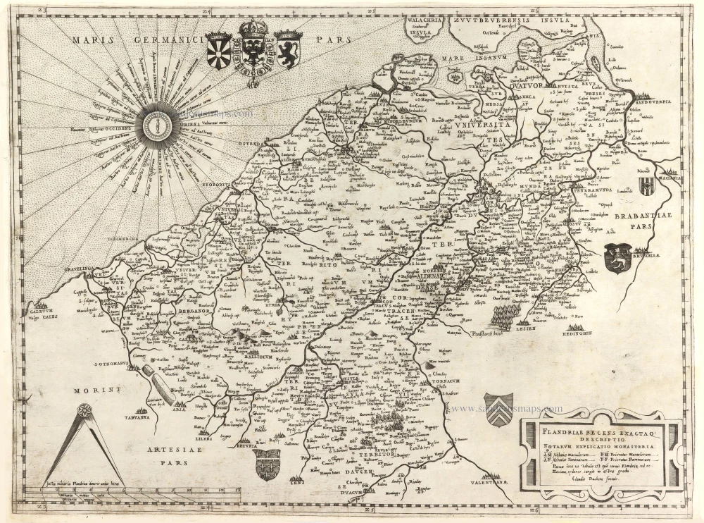
Flanders, by Claudio Duchetti, after Gerard Mercator. c. 1570
Flandriae recens exactaq descriptio.
[Item number: 29729]

Famous Mercator map of Flanders
Vlaanderen by A. Ortelius. 1579
Flandria.
[Item number: 22228]

Beautiful copy of this important map
Flanders (Vlaanderen), by Abraham Ortelius. 1584
Flandria.
[Item number: 32394]

Rare
Flanders (Vlaanderen), by Gerard de Jode. 1593
Exactissima Flandriae Descriptio.
[Item number: 30309]
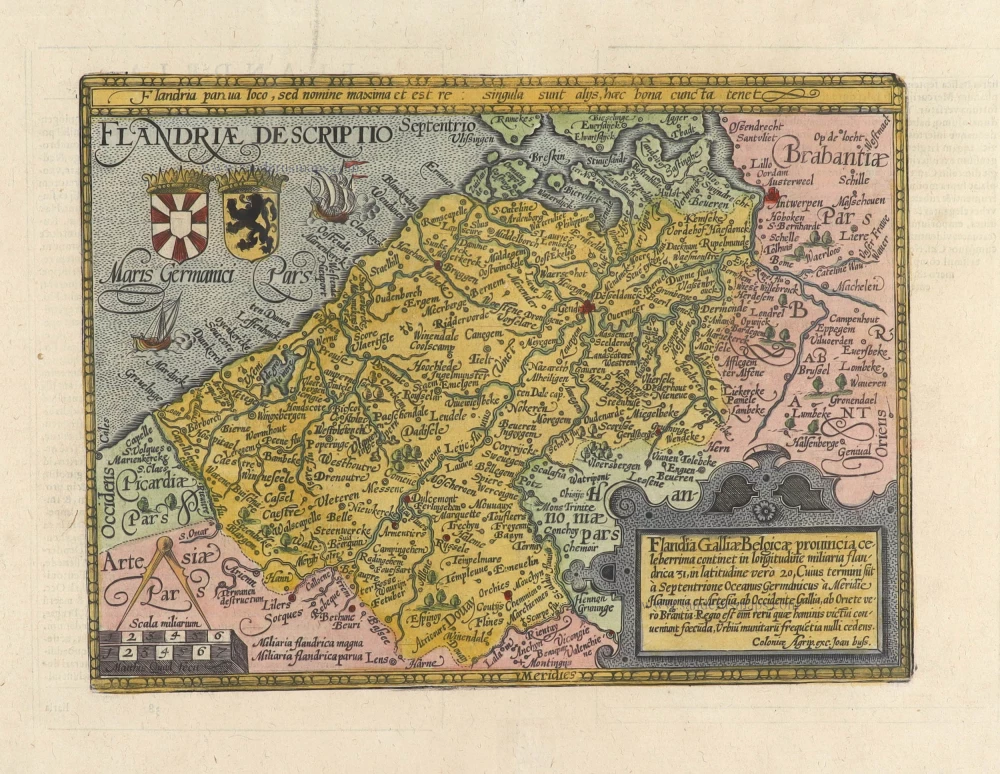
Vlaanderen by Abraham Ortelius 1601
Flandriae Comitatus Descriptio.
[Item number: 5767]

Flanders (Vlaanderen) by Petrus Kaerius (Pieter Van den Keere). 1617
Celeberrimi Flandriae Comitatus Typus.
[Item number: 28453]

Flanders (Vlaanderen) and Zeeland, by Willem Blaeu. 1640-43
Flandria et Zeelandia Comitatus.
[Item number: 27409]
Flanders (Vlaanderen) by Matthias Quad, published by J. Bussemacher. 1594
Flandriae Descriptio.
[Item number: 31256]

Western Flanders (West Vlaanderen) by N. Visscher II. 1683-1696
Flandriae Comitatus Pars Septentrionalis, comprehendens...
[Item number: 13092]

Spectacular 'Romain de Hooghe' map
Sea chart of the Channel - Flanders (Vlaanderen) - Zeeland, by Pieter Mortier. 1700
Carte Nouvelle des Costes de Hollande, Zeelande, Flandre,...
[Item number: 27176]

Sea chart of Flanders (Vlaanderen) & Zeeland, by Pieter Goos. 1667
Paskaert van de Zeeusche en Vlaemsche Kusten, tonende Alle...
[Item number: 19054]

Brabant, by A. Ortelius. 1595
Brabantiae Descriptio.
[Item number: 25573]

Brabant by Abraham Ortelius 1572
Brabantiae Germaniae Inferioris Nobilissimmae Provinciae...
[Item number: 26734]

The Duchy of Brabant by Pieter van den Keere (Petrus Kaerius). 1617
Brabantia Ducatus Machliniae Urbis Dominium.
[Item number: 28672]
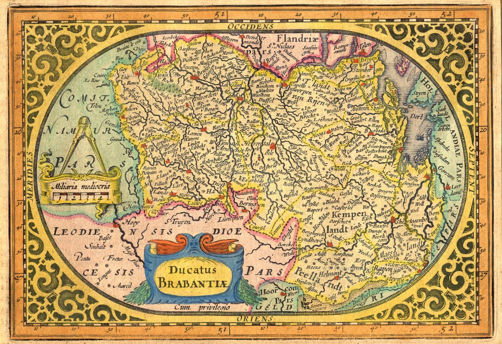
Brabant by Abraham Goos,published by Joannes Janssonius. 1631
Ducatus Brabantiae.
[Item number: 17723]

Brabant by M. Quad - J. Bussemacher. 1602
Brabantiae Belgarum provinciae recens exactaque descriptio.
[Item number: 25235]
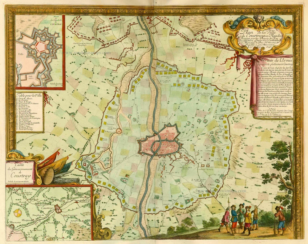
Kortrijk, by de Beaulieu S. 1694
Plan de la Ville de Courtray en Flandre, ...
[Item number: 21937]