
Flanders (Vlaanderen) by Domenico Zenoi. 1559


A reduced copy of Mercator's four-sheet map of 1540.
Rare Lafreri-type map. There are three variants of this map: One with the name of Dominicus Zenoi (Karrow 56/6.4), one without this name, and one with the name Camocio.
Exactissima Flandriae descriptio. Flandria, Caroli V. Aug. Imp. max. natione illustrissima, Belgice provinciae est . . . . Ad signum Bibliothecae Diui Marci. Dominicus Zenoi Venetus excidebat. Venetijs M.D.M.VIIII.
Item Number: 25774 Authenticity Guarantee
Category: Antique maps > Europe > Belgium
Rare Lafreri-type map of Flanders (Vlaanderen) by Domenico Zenoi.
Cartographer: G. Mercator
Date of the first edition: 1559
Date of this map: 1559
Date on map: 1559.
Copper engraving
Size: 40 x 49cm (15.6 x 19.1 inches)
Verso: Blank
Condition: Trimmed to neatline, over neatline at bottom.
Condition Rating: A
References: Bifolco-Ronca, Tav. 285; Tooley, #201; Karrow 56/6.4.
Separate publication.
A reduced copy of Mercator's four-sheet map of 1540.
Rare Lafreri-type map. There are three variants of this map: One with the name of Dominicus Zenoi (Karrow 56/6.4), one without this name, and one with the name Camocio.
Related items
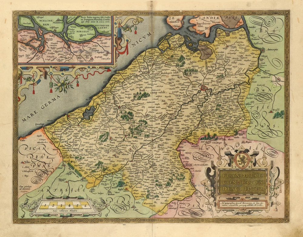
Flandriae Comitatus Descriptio. 1601
Vlaanderen by Abraham Ortelius
[Item number: 5767]

Flandria et Zeelandia Comitatus. 1659
Flanders (Vlaanderen) - Zeeland by Matthäus Merian & Martin Zeiller
[Item number: 12253]

Flandriae Comitatus Pars Septentrionalis, comprehendens Franconatum Brugensem et ejusdem subjacentia Territoria. 1683-1696
Western Flanders (West Vlaanderen) by N. Visscher II.
[Item number: 13092]

Paskaert van de Zeeusche en Vlaemsche Kusten, tonende Alle Drooghten, Diepten, en Ondiepten, tusschen t'Eylandt Schouwen en de Hoofden, Curieuselyck Beschreven door Dirck Davidsz 1667
Sea chart of Flanders (Vlaanderen) & Zeeland, by Pieter Goos.
[Item number: 19054]

Famous Mercator map of Flanders
Flandria. 1579
Vlaanderen by A. Ortelius.
[Item number: 22228]

Flandriae Comitatus Descriptio. 1612
Flanders (Vlaanderen) by Abraham Ortelius.
[Item number: 22978]

Le Comté de Flandre divisé en ses Chastellenies, et Balliages, &c. Le Franc de Bruges et Le Pays de Waes. c. 1705
Flanders (Vlaanderen), by Pieter Mortier.
[Item number: 28129]
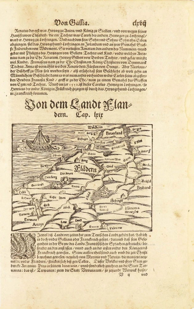
One of the oldest maps of Flanders
Flàdern. [Above map:] Von dem Landt Flandern. 1550
Flanders (Vlaanderen) by Sebastian Münster.
[Item number: 28922]
Rare.
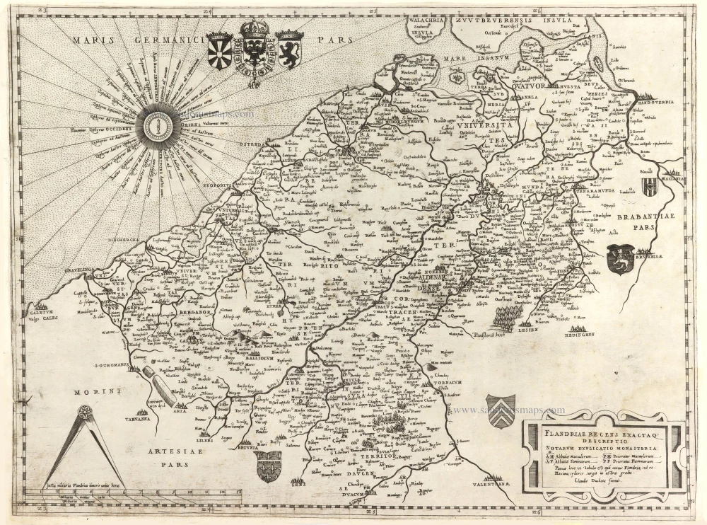
Flandriae recens exactaq descriptio. c. 1570
Flanders, by Claudio Duchetti, after Gerard Mercator.
[Item number: 29729]
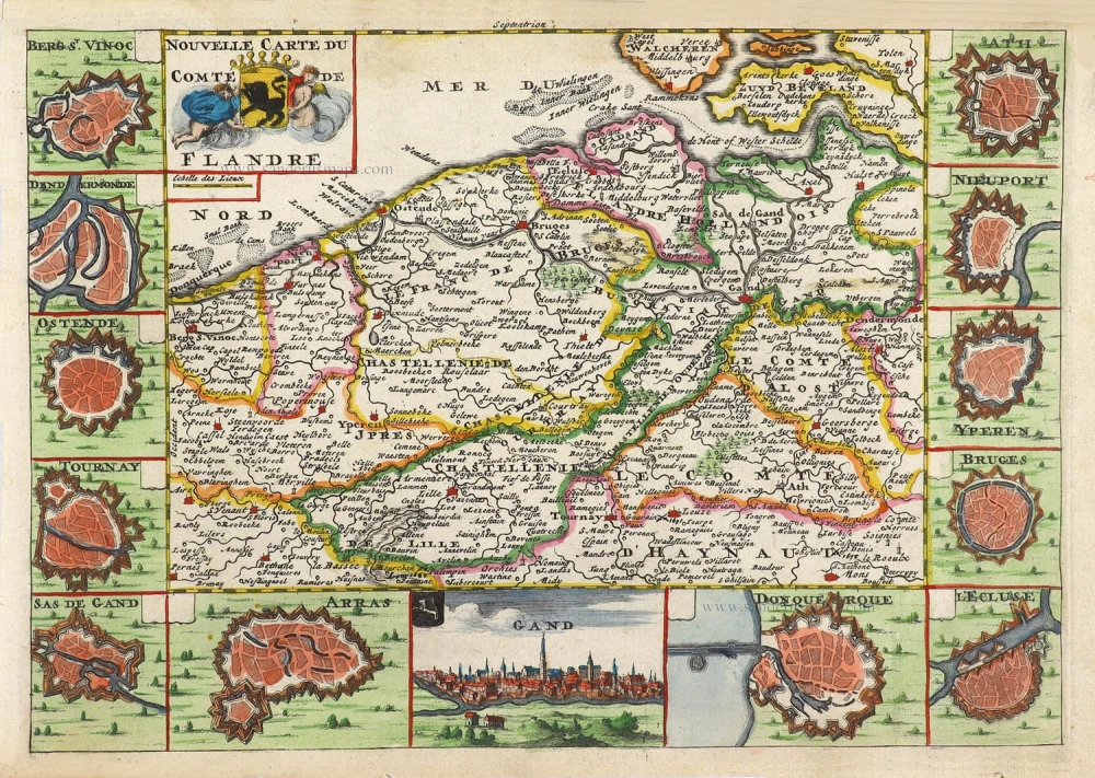
Nouvelle Carte du Comté de Flandre. 1706
Flanders (Vlaanderen) by Daniel De la Feuille.
[Item number: 29889]

Flandriae Comitatus Accuratissima Descriptio. c. 1658
Flanders (Vlaanderen) by Nicolaas Visscher I.
[Item number: 29980]

Rare
Exactissima Flandriae Descriptio. 1593
Flanders (Vlaanderen), by Gerard de Jode.
[Item number: 30309]
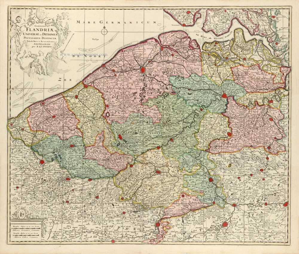
Comitatus Flandriae Universe in Ditiones Peculiares Distinctae. 1730-45
Flanders (Vlaanderen) by Ottens R. & J.
[Item number: 30524]

Very rare!
[No title] c. 1630-1635
Four atlas maps by Henricus Hondius, adapted to form a wall map of Flanders.
[Item number: 31002]

Early map of the Low Countries, 1561-1574
Fiandra, Brabantia, et Holanda Nuova. 1574
Low Countries by Girolamo Ruscelli.
[Item number: 31083]

Comitatus Flandriae. 1728
Flanders (Vlaanderen) by G. van Schagen, published by Pieter van der Aa.
[Item number: 31254]
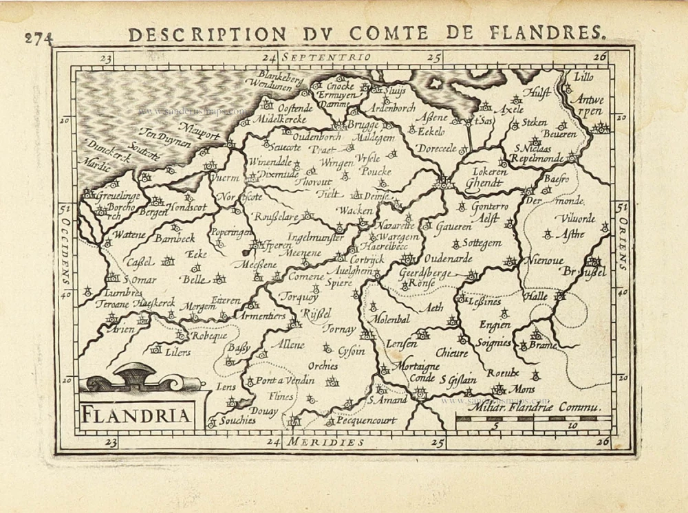
Flandriae Descriptio. 1594
Flanders (Vlaanderen) by Matthias Quad, published by J. Bussemacher.
[Item number: 31256]
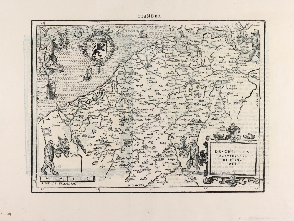
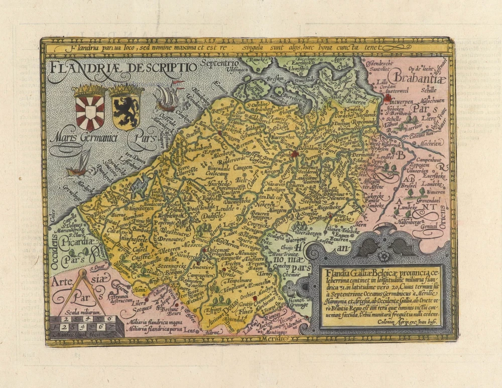
Descrittione Particulare di Fiandra. 1567
Flanders (Vlaanderen) by L. Guicciardini.
[Item number: 31517]
Flandria. 1618
Vlaanderen (Flanders) by Petrus Bertius, published by Jodocus Hondius II.
[Item number: 31592]

Comté de Flandres. 1633
Flanders (Vlaanderen) by Christophe Tassin.
[Item number: 31933]

Beautiful copy of this important map
Flandria. 1584
Flanders (Vlaanderen), by Abraham Ortelius.
[Item number: 32394]

Comitatus Flandriae in omnes ejusdem subjacentes Ditioescum adjacentibus accuratissime divisus. c. 1720
Flanders (Vlaanderen), by J.B. Homann.
[Item number: 32398]

Novissima Flandriae Comitatus Tabula cum omnibus praefecturis, etc. et Adjacentis Provinciis. 1696-1713
Flanders (Vlaanderen) by Theodore Danckerts.
[Item number: 32497]
The most beautiful 17th-century map of Flanders, with four decorative borders.
Comitatus Flandriae. 1652
Vlaanderen by C.J. Visscher.
[Item number: 33151]
new