
Johan van Doetechum's Leo Belgicus 1641, only recorded copy.
Leo Belgicus by Johan van Doetechum, published by C.J. Visscher. 1641
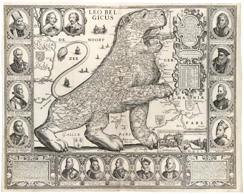


The Netherlands, depicted as a 'Lion passant', is bordered on three sides with medallions. These medallions contain the effigies of governors of the Netherlands. In addition to the portrait of King Philip II, the two side borders contain, in chronological order, the portraits of seven governors from Margaretha of Parma to Archduke Albert of Austria. The centre part of the lower border shows the portraits of the five Stadholders from Willem of Orange to Prince Maurice, nominated by the States General. The corners of the bottom border provide a lengthy note to the reader in Dutch (left) and French (right).
In the lower right corner, we find pictured views of two residences: North (PALATIUM COMITU HOLLAND) and South (PALATIUM BRUXELLENSE).
This map was a political statement. It was published to commemorate Dutch independence from the Spanish crown. With its explicit distinction between the governors of the northern and the southern provinces of the Netherlands - first Maurice and Albert, then Frederik Hendrik and Ferdinand - with its two pictures, one of the Court of Holland and one of the Court of Brussels, and by using the term 'utrinque Belgium' (the two Belgium's), this general map of the Netherlands is the first to emphasise the separation of the northern and the southern parts of the country.
The Netherlands, depicted as a lion, originated with the Austrian Michael von Aitzing (c. 1530-98), who inserted in his book De Leone Belgico (1583) a Leo Belgicus map engraved by Frans Hogenberg. In the preface of this work, von Aitzing explains why he chose this particular title and inserted the lion map. He explains that Caesar mentioned in his "Commentaries" that the 'Belgae' were the strongest tribes, and he, therefore, decided - partly because of the religious conflicts in the war against Spain - to introduce the Netherlands in the shape of a lion.
This is the third edition of the Leo Belgicus by Jan Jansz. Van Doetecum. The two earlier states, recorded by Van der Heijden in three examples only, are virtually unobtainable.
Van der Heyden describes this state as 1650. Our copy bears the date 1641 and is described by Spikmans, Germania Inferior, pp. 224-225, #41 as state 3. It is the only recorded copy, unknown to Van der Heijden, Schilder, and Hollstein.
The Visscher Family
For nearly a century, the members of the Visscher family were essential art dealers and map publishers in Amsterdam.
Claes Jansz. Visscher, or N.J. Piscator (1587-1652)
Claes Jansz. Vischer bought a house in Amsterdam, 'de gulden Bors', on the crucial Kalverstraat and changed the name into "In de Visscher"; under this title, the shop was to flourish for many years.
He was famous for his engravings and etchings of Dutch landscapes and 'historical scenes', such as sieges, battles, etc. These 'historical scenes' were considered contemporary illustrated news items, especially e.g. that of 'the Eighty Years' War'.
For the publication of his first atlas, he bought copperplates of the atlas Germania Inferior by Pieter van den Keere (1623).
In 1649, he published an atlas entitled Tabularum Geographicarum Contractarum, containing the same maps as Langenes' Caert Thresoor, for which Visscher had only new title pages engraved.
Claes Jansz. Visscher died in 1652. His wife, Neeltjen Florisdr., had already died in 1640. They had seven children, four of whom were still alive at Claes Jansz.'s death. One was Nicolaes Visscher I, who was to continue his father's business.
Nicolaes Visscher I (1618-1679)
Nicolaes Visscher I partnered with his father, continued the business, and stayed on the Kalverstraat 'in de Visscher' till his death.
In about 1657, the first edition of his Atlas Contractus Orbis Terrarum appeared.
Between 1664 and 1677, several editions of his Atlas Contractus appeared without a printed index, for these atlases had no fixed contents but were composed according to the buyer's financial leaping pole.
In May 1664, Nicolaes Visscher was admitted as a member of the Booksellers' Guild of his town. In July 1677, he was granted a patent of the States of Holland and West-Friesland for printing and publishing maps and atlases for 15 years.
After this, he again published an Atlas Contractus with a printed index. At about the same time, he also brought out an Atlas Minor.
Nicolaes Visscher II (1649-1702)
Nicolaes Visscher II inherited the 'shop' from his father. To obtain a new privilege, he applied to the States of Holland and West-Friesland in 1682 for a patent for printing and publishing maps. This patent was granted to him the same year. He moved the firm to the Dam, but it kept the same signboard: "In de Visscher".
Around 1683, he published his first Atlas Minor with a printed index of 91 maps. In 1684, an atlas Germania Inferior appeared. Till 1697, he published another number of atlases. He used his grandfather's (Claes Jansz.) maps less often now and relied more and more on his own.
The wars waged at this time initiated the compilation of maps of the countries where the armies operated. Many war maps were included in the various editions of his Atlas Minor.
After Nicolaes's death, his wife, Elizabeth Verseyl, published all the war maps as an atlas under the title De Stoel des Oorlogs in de Wereld (The seat of war in the world).
The widow of Nicolaes Visscher II (?-1726)
His widow continued the business energetically, and by her hand, under the name of her deceased husband, numerous atlases appeared, e.g., several editions of the Atlas Minor, an Atlas Maior and De Stoel des Oorlogs. The shop enjoyed a high reputation due to the assortment's incredible variety. Not only 'Visscher' maps but also maps of other publishers were obtainable. With the death of Elizabeth Verseyl in 1726, the last descendant died of a great map- and atlas-publishing firm in Amsterdam.
The Van Doetecum Family
Family of Dutch engravers and map publishers.
Joannes van Doetecum the Elder (Deventer ? - Haarlem, 1605)
Glazier, glass painter, etcher, engraver and mapmaker, was known for his etched works after genre scenes by Pieter Bruegel the Elder and maps for De Jode, Waghenaer, Ortelius, and van Linschoten. He engraved for Christopher Plantin and Officina Plantiniana.
Lucas van Doetecum (Active 1554-72, died before 1589)
Etcher and engraver, working mainly for Antwerp publishers with his brother Joannes the Elder.
Baptista van Doetecum (Deventer ? - 1611)
Etcher, engraver, book printer and publisher. Worked with his father, Joannes van Doetecum the Elder.
Joannes van Doetecum the Younger (Deventer ? - Rotterdam, 1630)
Etcher, engraver, printseller and publisher. Worked with his father and brother.
Leo Belgicus
Item Number: 31412 Authenticity Guarantee
Category: Antique maps > Europe > Belgium
Antique map - Leo Belgicus by J. Van Doetechum - C.J. Visscher.
Title: Leo Belgicus
Date of the first state/edition: 1598.
Date of this map: 1641.
Copper engraving, printed on paper.
Image size: 443 x 560mm (17½ x 22 inches).
Sheet size: 455 x 580mm (18 x 22¾ inches).
Verso: Blank.
Condition: Three vertical and one horizontal fold, side margins trimmed and backed with paper, good copy.
Condition Rating: A.
Separate publication
The Netherlands, depicted as a 'Lion passant', is bordered on three sides with medallions. These medallions contain the effigies of governors of the Netherlands. In addition to the portrait of King Philip II, the two side borders contain, in chronological order, the portraits of seven governors from Margaretha of Parma to Archduke Albert of Austria. The centre part of the lower border shows the portraits of the five Stadholders from Willem of Orange to Prince Maurice, nominated by the States General. The corners of the bottom border provide a lengthy note to the reader in Dutch (left) and French (right).
In the lower right corner, we find pictured views of two residences: North (PALATIUM COMITU HOLLAND) and South (PALATIUM BRUXELLENSE).
This map was a political statement. It was published to commemorate Dutch independence from the Spanish crown. With its explicit distinction between the governors of the northern and the southern provinces of the Netherlands - first Maurice and Albert, then Frederik Hendrik and Ferdinand - with its two pictures, one of the Court of Holland and one of the Court of Brussels, and by using the term 'utrinque Belgium' (the two Belgium's), this general map of the Netherlands is the first to emphasise the separation of the northern and the southern parts of the country.
The Netherlands, depicted as a lion, originated with the Austrian Michael von Aitzing (c. 1530-98), who inserted in his book De Leone Belgico (1583) a Leo Belgicus map engraved by Frans Hogenberg. In the preface of this work, von Aitzing explains why he chose this particular title and inserted the lion map. He explains that Caesar mentioned in his "Commentaries" that the 'Belgae' were the strongest tribes, and he, therefore, decided - partly because of the religious conflicts in the war against Spain - to introduce the Netherlands in the shape of a lion.
This is the third edition of the Leo Belgicus by Jan Jansz. Van Doetecum. The two earlier states, recorded by Van der Heijden in three examples only, are virtually unobtainable.
Van der Heyden describes this state as 1650. Our copy bears the date 1641 and is described by Spikmans, Germania Inferior, pp. 224-225, #41 as state 3. It is the only recorded copy, unknown to Van der Heijden, Schilder, and Hollstein.
The Visscher Family
For nearly a century, the members of the Visscher family were essential art dealers and map publishers in Amsterdam.
Claes Jansz. Visscher, or N.J. Piscator (1587-1652)
Claes Jansz. Vischer bought a house in Amsterdam, 'de gulden Bors', on the crucial Kalverstraat and changed the name into "In de Visscher"; under this title, the shop was to flourish for many years.
He was famous for his engravings and etchings of Dutch landscapes and 'historical scenes', such as sieges, battles, etc. These 'historical scenes' were considered contemporary illustrated news items, especially e.g. that of 'the Eighty Years' War'.
For the publication of his first atlas, he bought copperplates of the atlas Germania Inferior by Pieter van den Keere (1623).
In 1649, he published an atlas entitled Tabularum Geographicarum Contractarum, containing the same maps as Langenes' Caert Thresoor, for which Visscher had only new title pages engraved.
Claes Jansz. Visscher died in 1652. His wife, Neeltjen Florisdr., had already died in 1640. They had seven children, four of whom were still alive at Claes Jansz.'s death. One was Nicolaes Visscher I, who was to continue his father's business.
Nicolaes Visscher I (1618-1679)
Nicolaes Visscher I partnered with his father, continued the business, and stayed on the Kalverstraat 'in de Visscher' till his death.
In about 1657, the first edition of his Atlas Contractus Orbis Terrarum appeared.
Between 1664 and 1677, several editions of his Atlas Contractus appeared without a printed index, for these atlases had no fixed contents but were composed according to the buyer's financial leaping pole.
In May 1664, Nicolaes Visscher was admitted as a member of the Booksellers' Guild of his town. In July 1677, he was granted a patent of the States of Holland and West-Friesland for printing and publishing maps and atlases for 15 years.
After this, he again published an Atlas Contractus with a printed index. At about the same time, he also brought out an Atlas Minor.
Nicolaes Visscher II (1649-1702)
Nicolaes Visscher II inherited the 'shop' from his father. To obtain a new privilege, he applied to the States of Holland and West-Friesland in 1682 for a patent for printing and publishing maps. This patent was granted to him the same year. He moved the firm to the Dam, but it kept the same signboard: "In de Visscher".
Around 1683, he published his first Atlas Minor with a printed index of 91 maps. In 1684, an atlas Germania Inferior appeared. Till 1697, he published another number of atlases. He used his grandfather's (Claes Jansz.) maps less often now and relied more and more on his own.
The wars waged at this time initiated the compilation of maps of the countries where the armies operated. Many war maps were included in the various editions of his Atlas Minor.
After Nicolaes's death, his wife, Elizabeth Verseyl, published all the war maps as an atlas under the title De Stoel des Oorlogs in de Wereld (The seat of war in the world).
The widow of Nicolaes Visscher II (?-1726)
His widow continued the business energetically, and by her hand, under the name of her deceased husband, numerous atlases appeared, e.g., several editions of the Atlas Minor, an Atlas Maior and De Stoel des Oorlogs. The shop enjoyed a high reputation due to the assortment's incredible variety. Not only 'Visscher' maps but also maps of other publishers were obtainable. With the death of Elizabeth Verseyl in 1726, the last descendant died of a great map- and atlas-publishing firm in Amsterdam.
The Van Doetecum Family
Family of Dutch engravers and map publishers.
Joannes van Doetecum the Elder (Deventer ? - Haarlem, 1605)
Glazier, glass painter, etcher, engraver and mapmaker, was known for his etched works after genre scenes by Pieter Bruegel the Elder and maps for De Jode, Waghenaer, Ortelius, and van Linschoten. He engraved for Christopher Plantin and Officina Plantiniana.
Lucas van Doetecum (Active 1554-72, died before 1589)
Etcher and engraver, working mainly for Antwerp publishers with his brother Joannes the Elder.
Baptista van Doetecum (Deventer ? - 1611)
Etcher, engraver, book printer and publisher. Worked with his father, Joannes van Doetecum the Elder.
Joannes van Doetecum the Younger (Deventer ? - Rotterdam, 1630)
Etcher, engraver, printseller and publisher. Worked with his father and brother.