Antique maps catalogue
- All recent additions
-
Antique maps
- Polar maps
- World
-
Europe
- Europe Continent
- Belgium
- Belgium - Cities
- The Low Countries
- The Netherlands
- The Netherlands - Cities
- Luxembourg
- France
- France - Cities
- Germany
- Germany - Cities
- Austria
- Italy
- Italy - Cities
- Spain and Portugal
- Greece & Greek Islands
- Switzerland
- British Isles
- British Isles - Cities
- Northern Europe
- Central Europe
- Eastern Europe
- Southeastern Europe
- America
- Asia
- Africa
- Mediterranean Sea
- Australia
- Oceans
- Celestial Maps
- Curiosities
- Title Pages
- Books
- Medieval manuscripts
- Prints
![[ Zodiac sign ]](https://sanderusmaps.com/assets/IMG/webp/m31729.webp)
AQUARIUS, by Johann Bayer. 1624
[ Zodiac sign ]
[Item number: 31729]
![[ Zodiac sign ]](https://sanderusmaps.com/assets/IMG/webp/m31724.webp)
ARIES, by Johann Bayer. 1624
[ Zodiac sign ]
[Item number: 31724]
![[ Zodiac sign ]](https://sanderusmaps.com/assets/IMG/webp/m31727.webp)
CANCER, by Johann Bayer. 1624
[ Zodiac sign ]
[Item number: 31727]
![[ Zodiac sign ]](https://sanderusmaps.com/assets/IMG/webp/m31723.webp)
CAPRICORN, by Johann Bayer. 1624
[ Zodiac sign ]
[Item number: 31723]
![[ Zodiac sign ]](https://sanderusmaps.com/assets/IMG/webp/m31731.webp)
GEMINI, by Johann Bayer. 1624
[ Zodiac sign ]
[Item number: 31731]
![[ Zodiac sign ]](https://sanderusmaps.com/assets/IMG/webp/m31730.webp)
LEO, by Johann Bayer. 1624
[ Zodiac sign ]
[Item number: 31730]
![[ Zodiac sign ]](https://sanderusmaps.com/assets/IMG/webp/m31726.webp)
LIBRA, by Johann Bayer. 1624
[ Zodiac sign ]
[Item number: 31726]
![[ Zodiac sign ]](https://sanderusmaps.com/assets/IMG/webp/m31725.webp)
SAGITARIUS, by Johann Bayer. 1624
[ Zodiac sign ]
[Item number: 31725]
![[ Zodiac sign ]](https://sanderusmaps.com/assets/IMG/webp/m31733.webp)
SCORPIO, by Johann Bayer. 1624
[ Zodiac sign ]
[Item number: 31733]
![[ Zodiac sign ]](https://sanderusmaps.com/assets/IMG/webp/m31728.webp)
TAURUS, by Johann Bayer. 1624
[ Zodiac sign ]
[Item number: 31728]
![[ Zodiac sign ]](https://sanderusmaps.com/assets/IMG/webp/m31732.webp)
VIRGO, by Johann Bayer. 1624
[ Zodiac sign ]
[Item number: 31732]
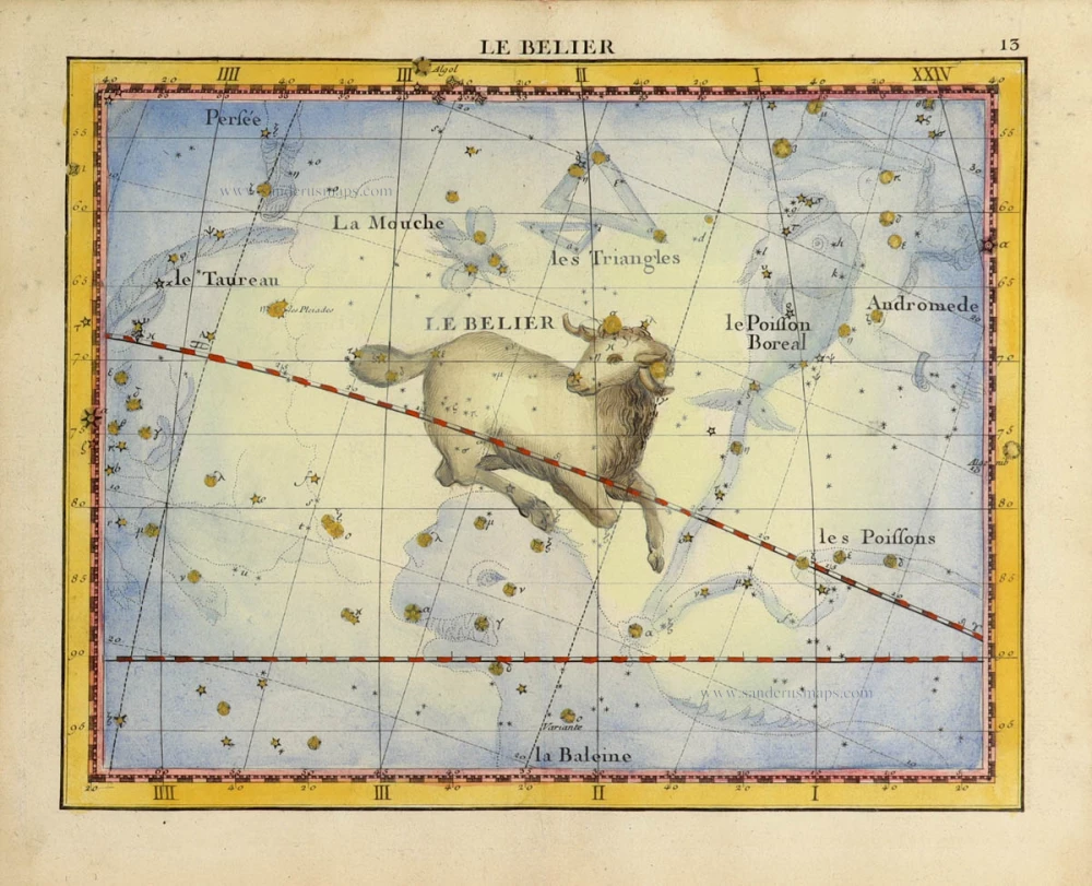
Zodiac sign of the ARIES, by John Flamsteed. 1776
Le Belier.
[Item number: 31835]

Zodiac sign of the CANCER, by John Flamsteed. 1776
Le Cancer.
[Item number: 31836]

Zodiac sign of the CAPRICORN and AQUARIUS, by John Flamsteed. 1776
Le Capricorne, et le Verseau.
[Item number: 31837]

Zodiac sign of the GEMINI, by John Flamsteed. 1776
Les Gemeaux.
[Item number: 31833]

Zodiac sign of the LIBRA and SCORPIO, by John Flamsteed. 1776
La Balance, et le Scorpion.
[Item number: 31838]

Zodiac sign of the PISCES, by John Flamsteed. 1776
Les Poissons.
[Item number: 31834]

Zodiac sign of the SAGITARIUS, by John Flamsteed. 1776
Le Sagittaire.
[Item number: 31839]

Zodiac sign of the VIRGO, by John Flamsteed. 1776
La Vierge
[Item number: 31831]

The frontispiece to Cellarius’s Harmonia Macrocosmica, renowned for its portrayals of both classical and contemporary astronomers.
Title page of Cellarius's Harmonia Macrocosmica 1708
Atlas Coelestis seu Harmonia Macrocosmica.
[Item number: 32642]
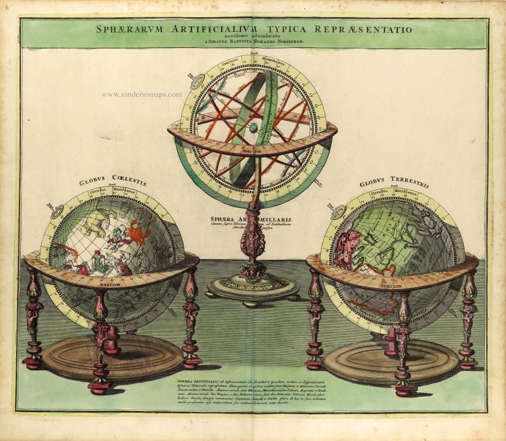
Armillary sphere, terrestrial & celestial globes by Johann Baptist Homann. 1730-37
Sphaerarum Artificialium Typica Repraesentatio Novissime...
[Item number: 28361]

Chart showing the motion of the planets according to the Copernican model, by J.G. Doppelmayr, published by J.B. Homann. c. 1720
Systema Solare et Planetarium ex hypothesi Copernicana secundum...
[Item number: 32036]

Map of the Moon
Lunar chart by Doppelmayr J.G. , published by J.B. Homann. c. 1720
Tabula Selenographica in qua Lunarium Macularum exacta...
[Item number: 32031]

Chart showing the Geocentric motion of the inner planets Mercury and Venus, by J.G. Doppelmayr, published by J.B. Homann. c. 1720
Motus in Coelo Spirales Quos Planetae inferiores Venus et...
[Item number: 32032]

Chart showing the motion of the planets Venus and Mercury during the year 1710, by J.G. Doppelmayr, published by J.B. Homann. c. 1720
Phaenomena Motuum Irregularium quos Planetae inferiores Venus et...
[Item number: 32033]
![Ephemerides Motuum Coelestium Geometrica In Quibus Secundum Hyupotheesin Copernicanum omina Motuum Planetariorum irregularium Phoenomena h.e. Directiones Stationes et Rerogradationes praecipue ad añ. Chr. 1708 ey 1709 ut et eorum causae curiose demonstra[n]tur.](https://sanderusmaps.com/assets/IMG/webp/m32034.webp)
Motions of the planets according to the Copernican theory of the solar system, by J.G. Doppelmayr, published by J.B. Homann. c. 1720
Ephemerides Motuum Coelestium Geometrica In Quibus Secundum...
[Item number: 32034]

Chart showing the solar system detailing the spiral motions of Mars, Jupiter, and Saturn, by J.G. Doppelmayr, published by J.B. Homann. c. 1720
Motus Planetarum Superiorum qui secundum Tychonis hypothesin...
[Item number: 32035]

Rare celestial map showing a new scientific depiction of the heavens.
Double hemisphere celestial map by Vincenzo Coronelli. 1691
Planisferii Celesti, Calcolati Per L'Anno MDCC, Corretti, Et...
[Item number: 30784]