Antique maps catalogue
- All recent additions
-
Antique maps
- Polar maps
- World
-
Europe
- Europe Continent
- Belgium
- Belgium - Cities
- The Low Countries
- The Netherlands
- The Netherlands - Cities
- Luxembourg
- France
- France - Cities
- Germany
- Germany - Cities
- Austria
- Italy
- Italy - Cities
- Spain and Portugal
- Greece & Greek Islands
- Switzerland
- British Isles
- British Isles - Cities
- Northern Europe
- Central Europe
- Eastern Europe
- Southeastern Europe
- America
- Asia
- Africa
- Mediterranean Sea
- Australia
- Oceans
- Celestial Maps
- Curiosities
- Title Pages
- Books
- Medieval manuscripts
- Prints

Very nice old colour
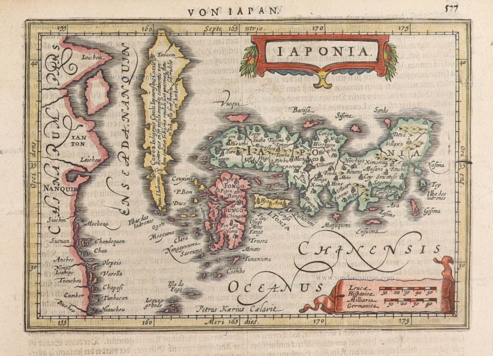
Japan, Jodocus Hondius. 1623
Iaponia.
[Item number: 27819]

The first accurate European map of Japan.
Japan by Abraham Ortelius. 1612
Iaponiae Insulae Descriptio.
[Item number: 31043]

Rare 1525 edition in nice old colour.
China - Japan by Lorenz Fries, after Martin Waldseemüller. 1525
No title - on verso: Ta. Superioris Indiae et Tartariae Maioris.
[Item number: 30659]

Early 1525 edition
China - Japan, by Lorenz Fries after Martin Waldseemüller. 1525
Ta. Superioris Indiae et Tartariae Maioris.
[Item number: 27928]

Japan by Jodocus Hondius. c. 1630-1650
Iaponia.
[Item number: 30857]

Japan & Korea by Johannes Janssonius 1641
Iaponiae Nova Desciptio.
[Item number: 26441]

Rare!
Japan by Philippe Briet, published by Pierre Mariette. c. 1658
Royaume du Iapon.
[Item number: 30911]

First map to show Korea as a peninsula. Excellent condition.
Japan & Korea by Joan Blaeu. 1655-1659
Iaponia Regnum.
[Item number: 29853]

Japan - Korea by Vincenzo Coronelli. 1696
Isola del Giapone e Penisola di Corea.
[Item number: 28757]

Japan by Abraham Ortelius, published by Johannes van Keerbergen. 1604
Iaponia Insula.
[Item number: 31739]

Japan by Langenes, published by Bertius P. 1602
Iapan.
[Item number: 12487]

Original coloured
Japan by Petrus Bertius. 1618
Iapan.
[Item number: 31455]

Japan, by Petrus Bertius 1618
Iapan.
[Item number: 32175]
Japan by G. Mercator, published by J. Janssonius. 1631
Iaponia.
[Item number: 30988]
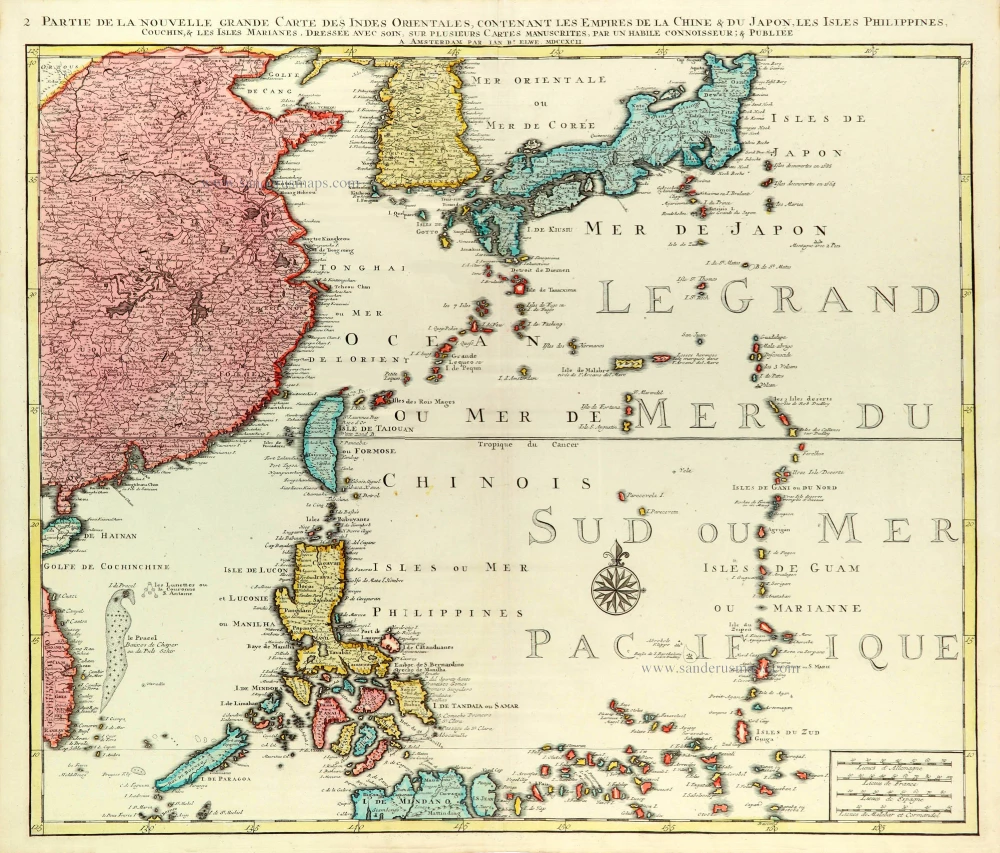
East Asia (Japan - Philippines) by J.B. Elwe. 1792
Partie de la Nouvelle Grande Carte des Indes Orientales...
[Item number: 31803]

Japan, by Z. Châtelain. 1719
L'Empire du Japon, tiré des Cartes des Japonnois.
[Item number: 29379]

In rare original colour
Kyoto - Decima (Japan), by Z. Châtelain. 1719
Vue et Description de la Ville de Meaco, Capitale du Japon avec...
[Item number: 31431]

Kyoto - Decima (Japan), by Z. Châtelain. 1719
Vue et Description de la Ville de Meaco, Capitale du Japon avec...
[Item number: 32303]
In rare old colour
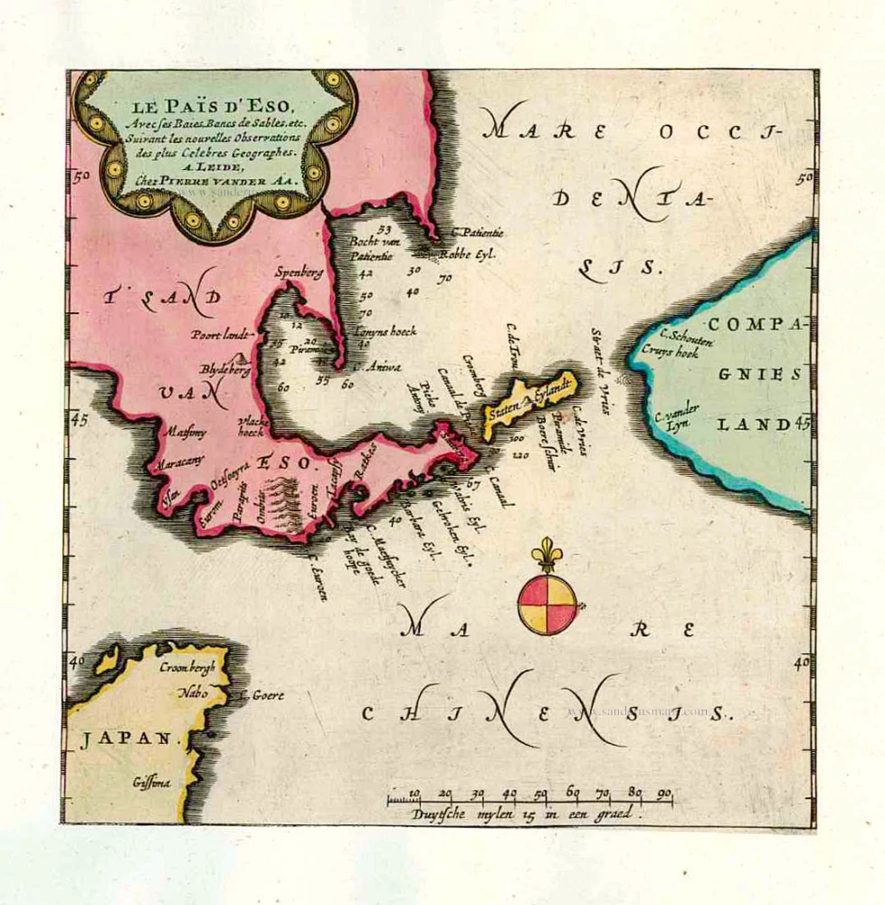
Eso (Hokkaido), by Pieter van der Aa. 1713
Le Païs d'Eso, Avec ses Baies, Bancs de Sables, etc.
[Item number: 26122]
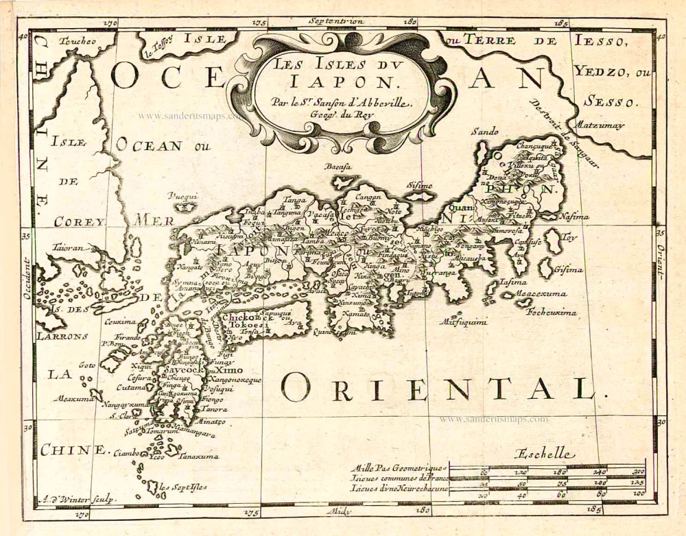
Japan, by Nicolas Sanson. 1683
Les Isles du Iapon.
[Item number: 27081]

Japan by François Valentyn (Valentijn). 1726
Nieuwe kaart van het Eyland Japan.
[Item number: 26876]
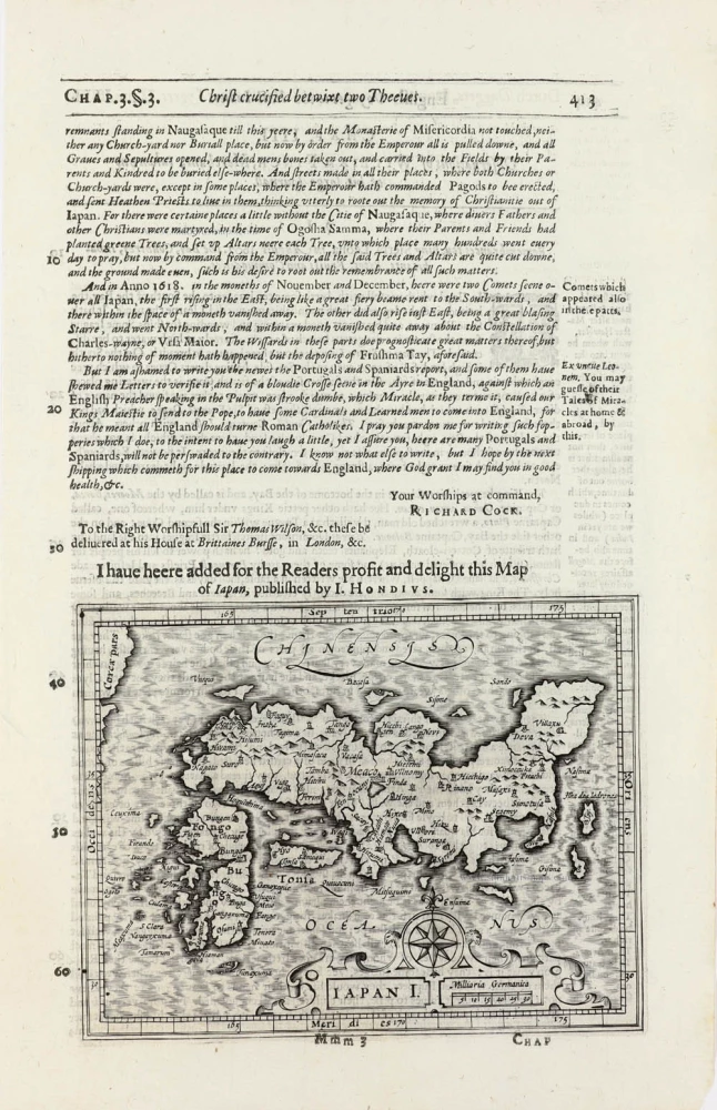
Japan by Jodocus Hondius, published by Samuel Purchas 1625
Iapan I.
[Item number: 32418]

Rare first state of Van der Aa's Japan map with Korea as an island.
Japan by Pieter Van der Aa. 1706
William Adams Reystogt na Oost-Indien; Avontuurlyk door de...
[Item number: 31841]

Japan, by Francesco Santini. 1776-79
L'Empire du Japon Divisé en sept principales parties, savoir,...
[Item number: 26975]

Japan - Korea by Jacques-Nicolas Bellin, published by A.F. Prévost. 1747
Carte des Isles du Japon et la Presqu’ Isle de Corée, avec les...
[Item number: 31880]
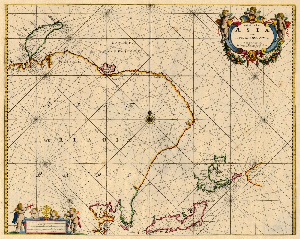
Northeast Asia, by Doncker H. 1688
Noordoost Cust van Asia van Iapan tot Nova Zemla
[Item number: 18466]
Exceptional good condition
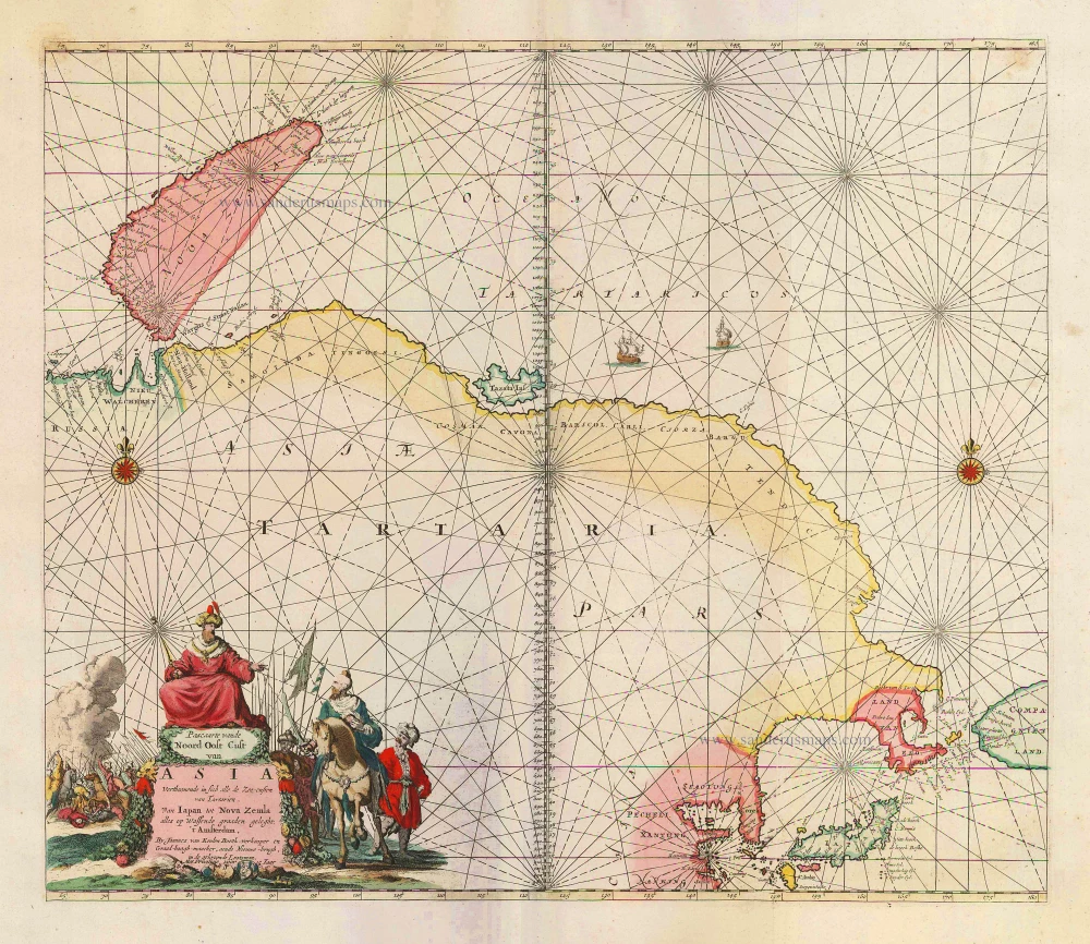
Sea chart of Northeast Asia, by J. Van Keulen. 1683
Pascaarte vande Noord Oost Cust van Asia Verthoonende in sich...
[Item number: 2443]

Tartary, by Abraham Ortelius. 1584
Tartariae Sive Magni Chami Regni Typus.
[Item number: 29224]

In rare old colour
Nagasaki and Hirado, by Pieter Van der Aa. 1713
Les Ports et Havres de Firando et Nangesaque.
[Item number: 26123]