
Japan - Korea by Jacques-Nicolas Bellin, published by A.F. Prévost. 1747

Antoine François Prévost (l'abbé)
Antoine François Prévost (1697–1763), also known as Abbé Prévost, was a French writer, historian, and traveller, best remembered for his literary works, particularly Manon Lescaut. However, beyond his contributions to literature, Prévost also played a notable role in disseminating geographical and cartographical knowledge during the 18th century.
Prévost demonstrated a keen interest in geography and exploration, which was reflected in his ambitious historical and travel writings. One of his most significant contributions to the field of cartography came through his monumental work "Histoire générale des voyages", published between 1746 and 1759. This multi-volume series compiled detailed narratives of travels and discoveries from various parts of the world, accompanied by maps and illustrations.
Though Prévost was not a cartographer by profession, his work was instrumental in popularising geographical knowledge in Enlightenment Europe. The maps included in Histoire générale des voyages were often created by prominent contemporary cartographers and engravers, providing readers with visual representations of remote and little-known regions. Through these collaborations, Prévost helped disseminate some of the era’s most critical cartographical works to a broader, non-specialist audience.
His writings, along with the associated maps, made a significant contribution to the European understanding of global geography, colonial territories, and navigation routes during a period of rapid maritime exploration and expansion. Prévost's work stands as a testament to the interconnection between literature, travel writing, and cartography in the Enlightenment period.
Jacques-Nicolas Bellin (1703-1772)
Jacques-Nicolas Bellin, a French geographer, was among the most important mapmakers of the eighteenth century. In 1721, at the age of 18, he was appointed hydrographer of the Ministry of the Navy following the French hydrographic office's creation and the Dépot of charts and plans of the Navy. Appointed hydrographic engineer in August 1741. Member of the Academy of the Navy and the Royal Society of London.
Over the course of a 50-year career, he drew the maps of several major works of his time such as Histoire et description générale de la Nouvelle-France de Charlevoix (1744); Histoire générale des voyages de l'Abbé Prévost (published between 1746 and 1759) ); Neptune François (1753), Hydrographie Françoise (1756-1765), and Petit Atlas Français (1763) - reissued as Petit Atlas Maritime (1765). He is the most copied cartographer of the 18th century.
His maps of Canada and the French territories of North America are of considerable value. This is all the more remarkable since, an archetype of the cabinet cartographer, Bellin never came to America. For his cartography of the St. Lawrence River, he entrusted handwritten maps to navigators to correct and enrich. With each return of these maps, he was updating his knowledge. Two basic needs drive its cartography of North America: to secure navigation on the St. Lawrence River and to claim for France the lands explored by the French in the Great Lakes region and along the Mississippi River.
Jacques-Nicolas Bellin died on March 21, 1772, in Versailles. In the burial certificate, he is described as "the first engineer of the navy and the deposit of plans, royal censor of the academy of navy and the royal society of London".
Jakob van der Schley (1715–1779)
Jakob van der Schley was a Dutch engraver and draftsman. He became renowned in the 18th century for his precise and delicate engraving work, particularly in the fields of cartography, portraiture, and book illustration.
Much of Van der Schley's work was created for illustrated books, atlases, and travel accounts. He is primarily known for his engravings featured in Prévost’s Histoire Générale des Voyages, a widely read French travel collection published in the mid-18th century. For this monumental work, Van der Schley produced numerous maps, views, and depictions of peoples and customs from around the world, often based on earlier drawings by other artists, which he skillfully adapted for print.
Carte des Isles du Japon et la Presqu’ Isle de Corée, avec les Costes de la Chine, depuis Pékin jusqu’à Canton.
Item Number: 31880 Authenticity Guarantee
Category: Antique maps > Asia > Japan
Japan - Korea by Jacques-Nicolas Bellin, published by A.F. Prévost.
Title: Carte des Isles du Japon et la Presqu’ Isle de Corée, avec les Costes de la Chine, depuis Pékin jusqu’à Canton.
Par N. Bellin Ingr de la Marine.
J.V. Schley direx.
Dutch title beneath the bottom neatline.
Translation of title: Map of the Islands of Japan, and the peninsula of Korea, with the coast of China from Beijing to Canton.
Cartographer: J.N. Bellin.
Engraver: Jacob van der Schley.
Date of the first edition: 1747.
Date of this map: 1747.
Copper engraving, printed on paper.
Image size: 220 x 285mm (8¾ x 11¼ inches).
Sheet size: 260 x 365mm (10¼ x 14¼ inches).
Verso: Blank.
Condition: Excellent, folds as issued.
Condition Rating: A+.
From: Prévost d'Exiles A. Fr. Historische Beschryving der Reizen. Den Haag, P. De Hondt, 1747-80. Enlarged Dutch translation of the French edition of 1746-89.
Antoine François Prévost (l'abbé)
Antoine François Prévost (1697–1763), also known as Abbé Prévost, was a French writer, historian, and traveller, best remembered for his literary works, particularly Manon Lescaut. However, beyond his contributions to literature, Prévost also played a notable role in disseminating geographical and cartographical knowledge during the 18th century.
Prévost demonstrated a keen interest in geography and exploration, which was reflected in his ambitious historical and travel writings. One of his most significant contributions to the field of cartography came through his monumental work "Histoire générale des voyages", published between 1746 and 1759. This multi-volume series compiled detailed narratives of travels and discoveries from various parts of the world, accompanied by maps and illustrations.
Though Prévost was not a cartographer by profession, his work was instrumental in popularising geographical knowledge in Enlightenment Europe. The maps included in Histoire générale des voyages were often created by prominent contemporary cartographers and engravers, providing readers with visual representations of remote and little-known regions. Through these collaborations, Prévost helped disseminate some of the era’s most critical cartographical works to a broader, non-specialist audience.
His writings, along with the associated maps, made a significant contribution to the European understanding of global geography, colonial territories, and navigation routes during a period of rapid maritime exploration and expansion. Prévost's work stands as a testament to the interconnection between literature, travel writing, and cartography in the Enlightenment period.
Jacques-Nicolas Bellin (1703-1772)
Jacques-Nicolas Bellin, a French geographer, was among the most important mapmakers of the eighteenth century. In 1721, at the age of 18, he was appointed hydrographer of the Ministry of the Navy following the French hydrographic office's creation and the Dépot of charts and plans of the Navy. Appointed hydrographic engineer in August 1741. Member of the Academy of the Navy and the Royal Society of London.
Over the course of a 50-year career, he drew the maps of several major works of his time such as Histoire et description générale de la Nouvelle-France de Charlevoix (1744); Histoire générale des voyages de l'Abbé Prévost (published between 1746 and 1759) ); Neptune François (1753), Hydrographie Françoise (1756-1765), and Petit Atlas Français (1763) - reissued as Petit Atlas Maritime (1765). He is the most copied cartographer of the 18th century.
His maps of Canada and the French territories of North America are of considerable value. This is all the more remarkable since, an archetype of the cabinet cartographer, Bellin never came to America. For his cartography of the St. Lawrence River, he entrusted handwritten maps to navigators to correct and enrich. With each return of these maps, he was updating his knowledge. Two basic needs drive its cartography of North America: to secure navigation on the St. Lawrence River and to claim for France the lands explored by the French in the Great Lakes region and along the Mississippi River.
Jacques-Nicolas Bellin died on March 21, 1772, in Versailles. In the burial certificate, he is described as "the first engineer of the navy and the deposit of plans, royal censor of the academy of navy and the royal society of London".
Jakob van der Schley (1715–1779)
Jakob van der Schley was a Dutch engraver and draftsman. He became renowned in the 18th century for his precise and delicate engraving work, particularly in the fields of cartography, portraiture, and book illustration.
Much of Van der Schley's work was created for illustrated books, atlases, and travel accounts. He is primarily known for his engravings featured in Prévost’s Histoire Générale des Voyages, a widely read French travel collection published in the mid-18th century. For this monumental work, Van der Schley produced numerous maps, views, and depictions of peoples and customs from around the world, often based on earlier drawings by other artists, which he skillfully adapted for print.
Related items

Iapan. 1602
Japan by Langenes, published by Bertius P.
[Item number: 12487]

Iaponiae Nova Desciptio. 1641
Japan & Korea by Johannes Janssonius
[Item number: 26441]

Nieuwe kaart van het Eyland Japan. 1726
Japan by François Valentyn (Valentijn).
[Item number: 26876]

L'Empire de la Chine, avec la Tartarie Chinoise d'après l'Atlas Chinois. 1776-79
China with Korea and Japan, by Paolo Santini.
[Item number: 26974]
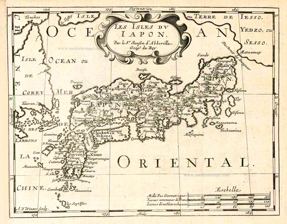
Les Isles du Iapon. 1683
Japan, by Nicolas Sanson.
[Item number: 27081]

Isola del Giapone e Penisola di Corea. 1696
Japan - Korea by Vincenzo Coronelli.
[Item number: 28757]

L'Empire du Japon, tiré des Cartes des Japonnois. 1719
Japan, by Z. Châtelain.
[Item number: 29379]

First map to show Korea as a peninsula. Excellent condition.
Iaponia Regnum. 1655-1659
Japan & Korea by Joan Blaeu.
[Item number: 29853]

Iaponia. c. 1630-1650
Japan by Jodocus Hondius.
[Item number: 30857]

Rare!
Royaume du Iapon. c. 1658
Japan by Philippe Briet, published by Pierre Mariette.
[Item number: 30911]
Iaponia. 1631
Japan by G. Mercator, published by J. Janssonius.
[Item number: 30988]

The first accurate European map of Japan.
Iaponiae Insulae Descriptio. 1612
Japan by Abraham Ortelius.
[Item number: 31043]

In rare original colour
Vue et Description de la Ville de Meaco, Capitale du Japon avec d'autres Particularitez du Pays. 1719
Kyoto - Decima (Japan), by Z. Châtelain.
[Item number: 31431]

Original coloured
Iapan. 1618
Japan by Petrus Bertius.
[Item number: 31455]

Iaponia Insula. 1604
Japan by Abraham Ortelius, published by Johannes van Keerbergen.
[Item number: 31739]
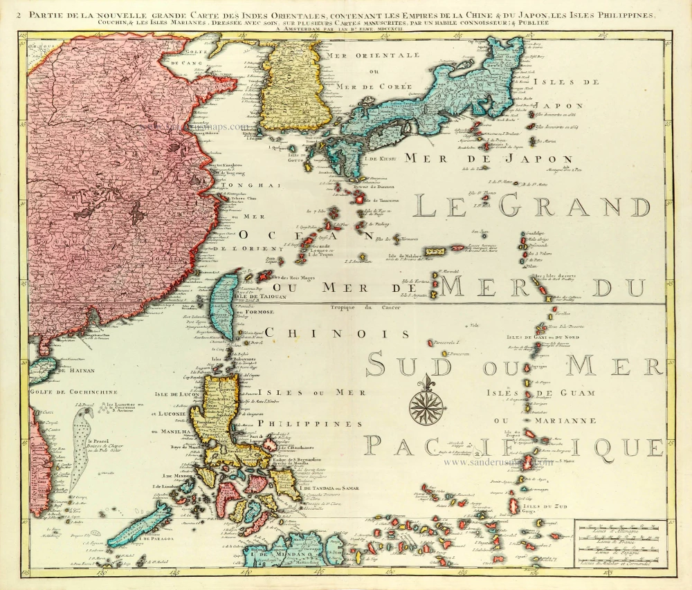
Partie de la Nouvelle Grande Carte des Indes Orientales Contenant les Empires de la Chine, du Japon, les Isles Philippines, Couchin, & les Isles Marianes, 1792
East Asia (Japan - Philippines) by J.B. Elwe.
[Item number: 31803]

Rare first state of Van der Aa's Japan map with Korea as an island.
William Adams Reystogt na Oost-Indien; Avontuurlyk door de Straat van Magellaan, in't Keyzerryk van Iapan voleyndigd. 1706
Japan by Pieter Van der Aa.
[Item number: 31841]

Iapan. 1618
Japan, by Petrus Bertius
[Item number: 32175]