Antique maps catalogue
- All recent additions
-
Antique maps
- Polar maps
- World
-
Europe
- Europe Continent
- Belgium
- Belgium - Cities
- The Low Countries
- The Netherlands
- The Netherlands - Cities
- Luxembourg
- France
- France - Cities
- Germany
- Germany - Cities
- Austria
- Italy
- Italy - Cities
- Spain and Portugal
- Greece & Greek Islands
- Switzerland
- British Isles
- British Isles - Cities
- Northern Europe
- Central Europe
- Eastern Europe
- Southeastern Europe
- America
- Asia
- Africa
- Mediterranean Sea
- Australia
- Oceans
- Celestial Maps
- Curiosities
- Title Pages
- Books
- Medieval manuscripts
- Prints

Dendermonde, by Rapin de Thoyras. 1758
Plan of the City of Dendermonde, and the manner in which it was...
[Item number: 22644]

East West-Vlaanderen by J.A. Colom 1635
Partie de la Flandre Orientale.
[Item number: 32437]

Antique map of Ekeren by Fricx E. 1712
Plan de la bataille de Wilmerdonck près d'Eeckeren donnée le 30....
[Item number: 29544]

West Flanders, by Vincenzo Coronelli. 1696
Fiandra Parte Occidentale,
[Item number: 29223]
![[No title]](https://sanderusmaps.com/assets/IMG/webp/M31002.webp)
Very rare!
Four atlas maps by Henricus Hondius, adapted to form a wall map of Flanders. c. 1630-1635
[No title]
[Item number: 31002]
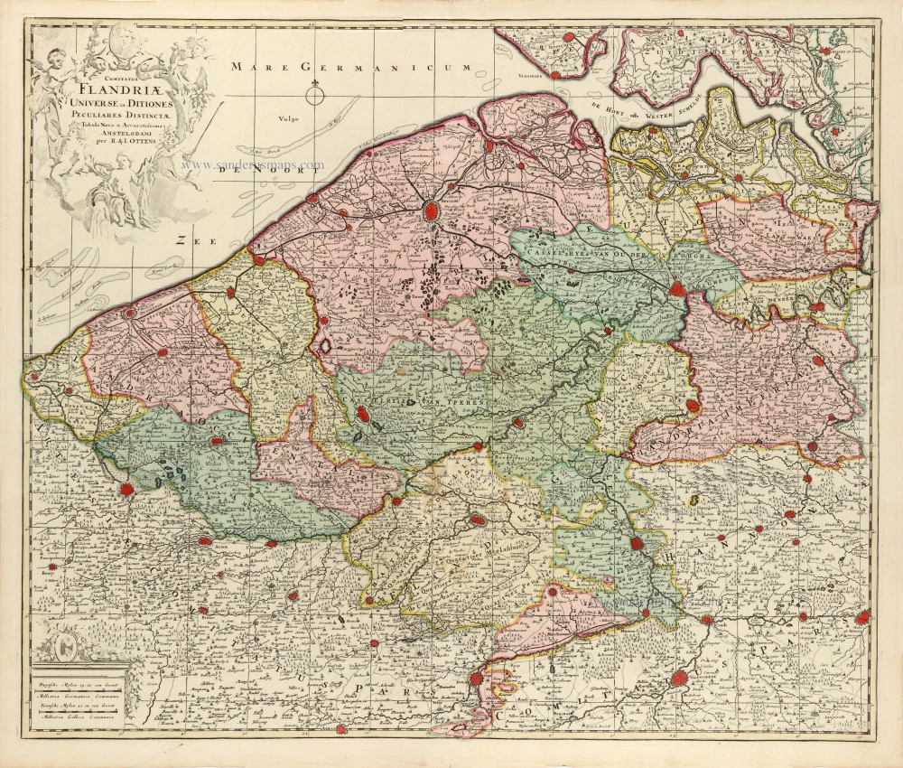
Flanders (Vlaanderen) by Ottens R. & J. 1730-45
Comitatus Flandriae Universe in Ditiones Peculiares Distinctae.
[Item number: 30524]

Flanders (Vlaanderen), by Pieter Mortier. c. 1705
Le Comté de Flandre divisé en ses Chastellenies, et Balliages,...
[Item number: 28129]
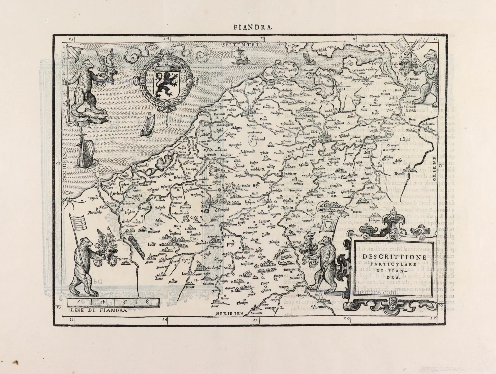
Flanders (Vlaanderen) by L. Guicciardini. 1567
Descrittione Particulare di Fiandra.
[Item number: 31517]
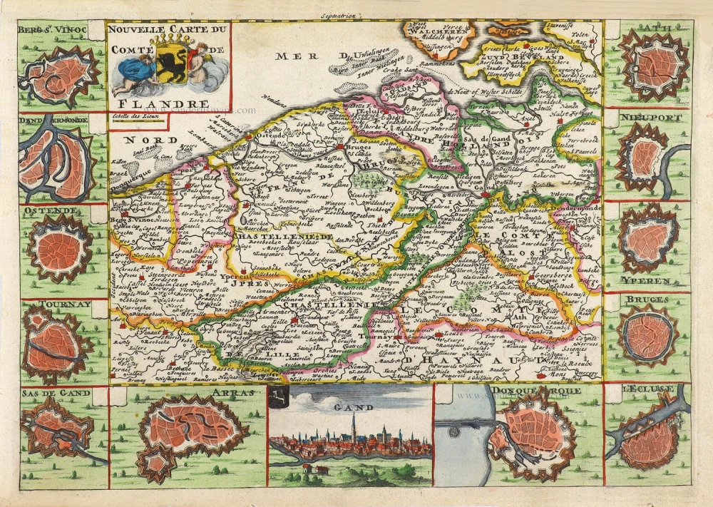
Flanders (Vlaanderen) by Daniel De la Feuille. 1706
Nouvelle Carte du Comté de Flandre.
[Item number: 29889]

Flanders (Vlaanderen) by Abraham Ortelius. 1612
Flandriae Comitatus Descriptio.
[Item number: 22978]

Flanders (Vlaanderen) by G. van Schagen, published by Pieter van der Aa. 1728
Comitatus Flandriae.
[Item number: 31254]

Flanders (Vlaanderen) by Nicolaas Visscher I. c. 1658
Flandriae Comitatus Accuratissima Descriptio.
[Item number: 29980]

Flanders (Vlaanderen) by Christophe Tassin. 1633
Comté de Flandres.
[Item number: 31933]

RARE
Chart by Anthonie Jacobsz, the Flemish coast. 1644
De Cust van Vlaenderen Beginnende vande Wielingen tot aen de...
[Item number: 32608]

Flanders (Vlaanderen) - Zeeland by Matthäus Merian & Martin Zeiller 1659
Flandria et Zeelandia Comitatus.
[Item number: 12253]

Flanders, by Pieter Van der Aa. 1713
Carte du Comté de Flandre.
[Item number: 26053]
![[No title]](https://sanderusmaps.com/assets/IMG/webp/m22635.webp)
French Flanders (Frans Vlaanderen) by Henricus Hondius. 1633 (or earlier)
[No title]
[Item number: 22635]

Gallo-Flandria, by Willem Blaeu. 1643
Galloflandria in qua Castellaniae Lilana, Duacena, &Orchiesa,...
[Item number: 27125]

Aalst - Brussels by E.H. Fricx. 1712
Carte Particulière des environs de Bruxelles avec le Bois de...
[Item number: 32595]

The scarce censored first issue of Ortelius's Hainault map, dated 1572.
Hainault (Hainaut) by Abraham Ortelius. 1584
Nobilis Hannoniae Comitatus Descrip.
[Item number: 30676]

Hainaut by Christophe Tassin. 1633
Carte du Conté de Haynault.
[Item number: 31934]

Hainaut by N. Visscher After 1705
Comitatus Hannoniae Tabula,
[Item number: 32629]

Hainaut by Petrus Kaerius (Pieter Van den Keere), published by Claes Jansz. Visscher. 1634
Nobilis Hannoniae Com. Descriptio.
[Item number: 30736]

Hainaut - Cambrai, by Pieter Mortier. 1708
Le Comté de Haynaut, divisé en Chatellenies, Balliages,...
[Item number: 28223]

Hainaut - Namur, by G. Mercator 1619
Hannonia Namurcum Comitatus.
[Item number: 12182]

Hainaut - Namur, by Blaeu W. & J. 1640-43
Comitatuum Hannoniae Et Namurci Descriptio
[Item number: 13985]

Heraldic Garden of the County of Hainaut, by Georg Braun and Frans Hogenberg. 1581
Nobilis Hannoniae Comitatus Descriptio. Pays de Haynault Tenu de...
[Item number: 25340]

Ieper (Castellania), by A. Sanderus. 1641
Nova Et Exacta Tabula Geographica Salae Et Castellaniae Iprensis...
[Item number: 32725]

Imperial Flanders (Oost-Vlaanderen) by Johannes Janssonius. 1656-80
Flandriae Partes duae, quarum altera Proprietaria, altera...
[Item number: 28618]

Keizerlijk Vlaanderen of Oost Vlaanderen (Imperial Flanders or Eastern Flanders), by Willem Blaeu. 1643
Flandriae Partes duae, quarum altera Proprietata altera...
[Item number: 29935]
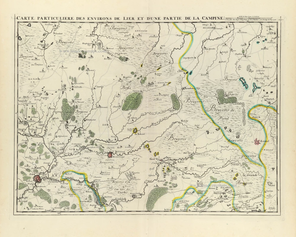
De Kempen by E.H. Fricx. 1712
Carte Particulière des environs de Lier et d'une partie de la...
[Item number: 32592]

de Kempen by Visscher N. II c. 1716
Tetrachiae Antverpiensis Pars Meridionalis.
[Item number: 32624]
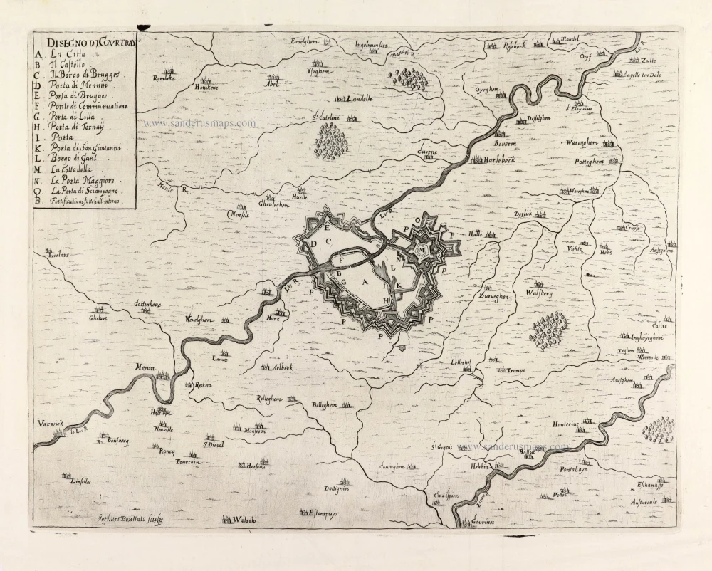
Kortrijk and surrounding, by Gualdo Priorato. 1670
Disegno di Courtray.
[Item number: 31429]
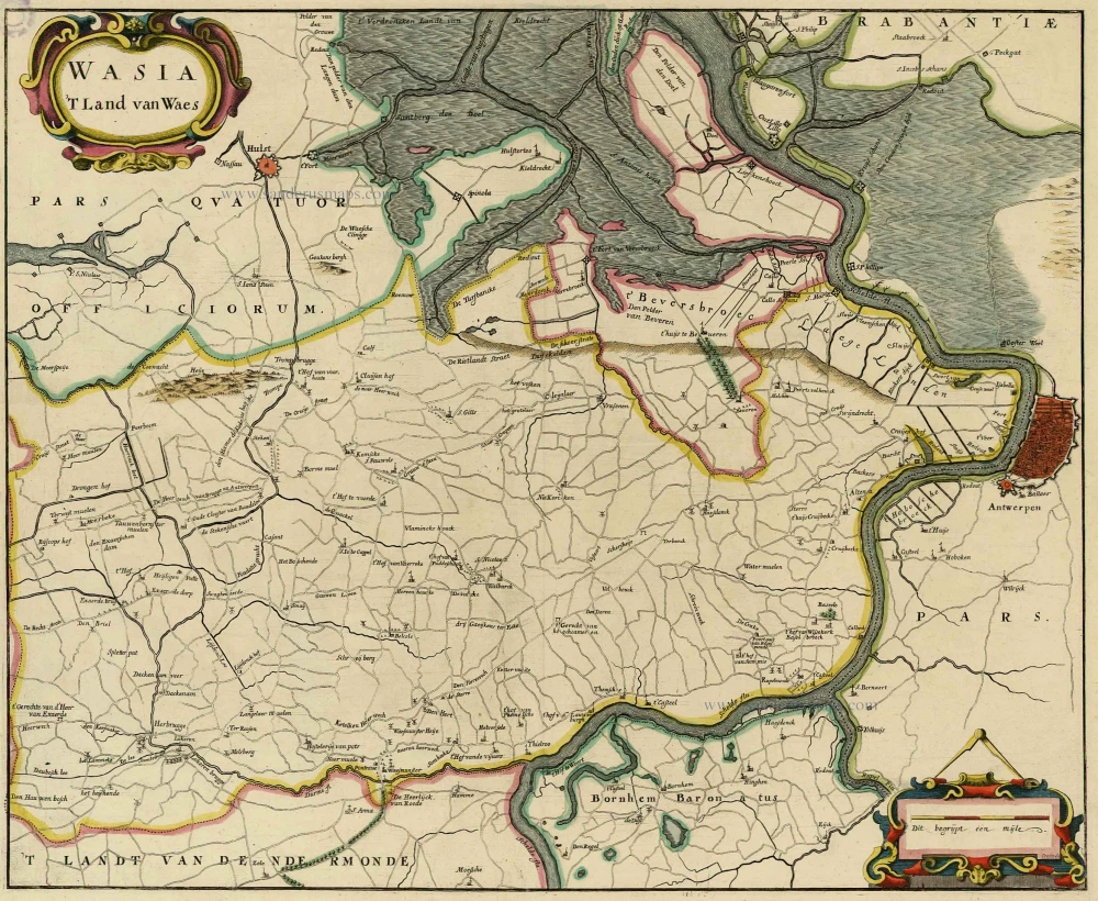
Land van Waas by Antonius Sanderus. 1732
Wasia. 't Land van Waes.
[Item number: 20792]

Land van Waas by Eugène Fricx. 1712
Carte tres-particuliere du Paijs de Waes, ou sont marqués les...
[Item number: 29545]

Land van Waas by Antonius Sanderus, published by Joan Blaeu. 1662
Wasia. 't Land van Waes.
[Item number: 31255]