
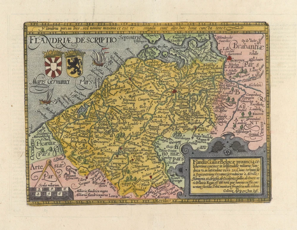
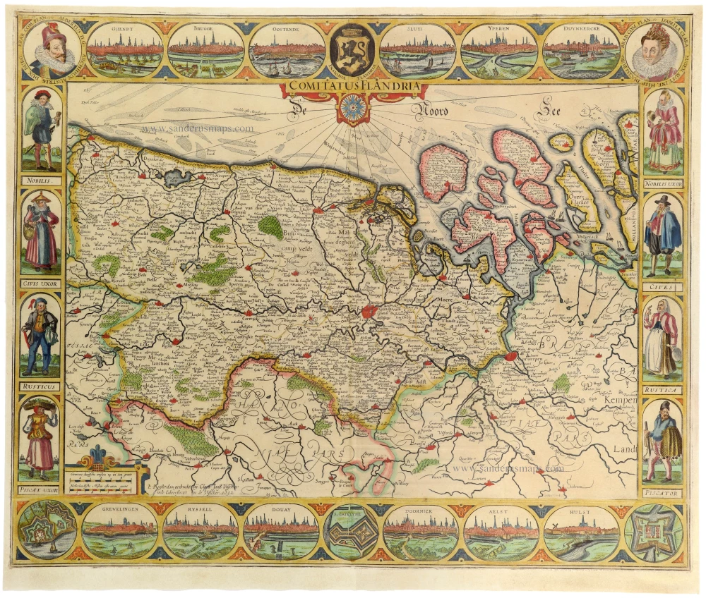
Flanders (Vlaanderen) by Christophe Tassin. 1633

Tassin Christophe Nicolas. (? - 1660)
Christophe Tassin was a French cartographer known for his atlases of France, Spain, Germany, and Switzerland.
He was 'Ingenieur-géographe du roi'. He used this title only between 1633 and 1638. In 1633 Tassin published an atlas of France and Spain, Cartes générales des provinces de France et d’ Espagne; one of Germany, Cartes généralis des royaumes et provinces de la haute et basse Allemagna; and one of the Low Countries, Plans et profils des principales villes du duché de Lorraine, avec les cartes generale et particulieres de chacun gouvernement d’iucelles.
In 1644, Tassin ended his work and sold his copper plates of maps to Antoine de Fer, who published them in many subsequent editions.
Comté de Flandres.
Item Number: 31933 Authenticity Guarantee
Category: Antique maps > Europe > Belgium
Flanders (Vlaanderen) by Christophe Tassin. RARE.
Title: Comté de Flandres.
Oriented to the west.
Date of the first edition: 1633.
Date of this map: 1633.
Copper engraving, printed on paper.
Image size: 105 x 150mm (4¼ x 6 inches).
Sheet size: 155 x 195mm (6 x 7¾ inches).
Verso: Blank.
Condition: Excellent.
Condition Rating: A+.
From: Tassin C. Cartes Generales des Royaumes et Provinces de la Haute et Basse Allemagne. Reveues, corrigées & augmentées par le sieur Tassin Geographe ordinaire de sa Majesté. A Paris, Chez Martin Gobert au Palais en la gallerie des prisonniers. M.DC.XXXIII. (1633). (Pastoureau, p. 445, Tassin IV Aa 1633)
Tassin Christophe Nicolas. (? - 1660)
Christophe Tassin was a French cartographer known for his atlases of France, Spain, Germany, and Switzerland.
He was 'Ingenieur-géographe du roi'. He used this title only between 1633 and 1638. In 1633 Tassin published an atlas of France and Spain, Cartes générales des provinces de France et d’ Espagne; one of Germany, Cartes généralis des royaumes et provinces de la haute et basse Allemagna; and one of the Low Countries, Plans et profils des principales villes du duché de Lorraine, avec les cartes generale et particulieres de chacun gouvernement d’iucelles.
In 1644, Tassin ended his work and sold his copper plates of maps to Antoine de Fer, who published them in many subsequent editions.
Related items
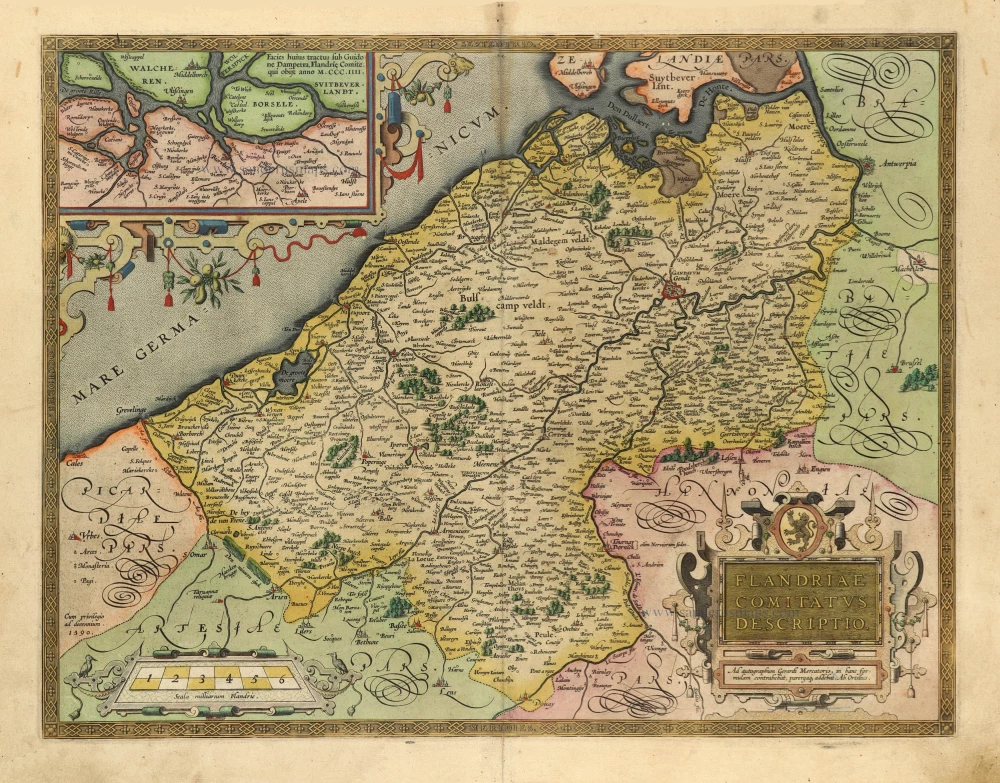
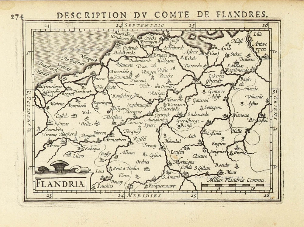
Flandriae Comitatus Descriptio. 1601
Vlaanderen by Abraham Ortelius
[Item number: 5767]

Famous Mercator map of Flanders
Flandria. 1579
Vlaanderen by A. Ortelius.
[Item number: 22228]

Flandriae Comitatus Descriptio. 1612
Flanders (Vlaanderen) by Abraham Ortelius.
[Item number: 22978]

Exactissima Flandriae descriptio. Flandria, Caroli V. Aug. Imp. max. natione illustrissima, Belgice provinciae est . . . . Ad signum Bibliothecae Diui Marci. Dominicus Zenoi Venetus excidebat. Venetijs M.D.M.VIIII. 1559
Flanders (Vlaanderen) by Domenico Zenoi.
[Item number: 25774]

Carte du Comté de Flandre. 1713
Flanders, by Pieter Van der Aa.
[Item number: 26053]

Very important naval print: The first print published by the Blaeu family
Typus octo longaru[m] naviu[m]. Anno M.VI.c.II ab Hispaniae rege missaru[m] ad Oceanum Belgicum infestandu[m]. quarum naviu[m] quatuor Angloru[m] atq³ Hollandoru[m] virtute conquassatae sunt et submersae: ceterae naufragio periere. c. 1602
Defeat of Spanish galleys by an Anglo-Dutch naval force off the coast of Flanders, 3-4 Oct. 1602. by Willem Blaeu
[Item number: 26804]

Comitatus Flandria. 1637
Flanders (Vlaanderen), by Pieter Verbiest.
[Item number: 27128]

Spectacular 'Romain de Hooghe' map
Carte Nouvelle des Costes de Hollande, Zeelande, Flandre, Picardie, & Normandie ... Chez Pierre Mortier, 1693. 1700
Sea chart of the Channel - Flanders (Vlaanderen) - Zeeland, by Pieter Mortier.
[Item number: 27176]

Flandria et Zeelandia Comitatus. 1640-43
Flanders (Vlaanderen) and Zeeland, by Willem Blaeu.
[Item number: 27409]

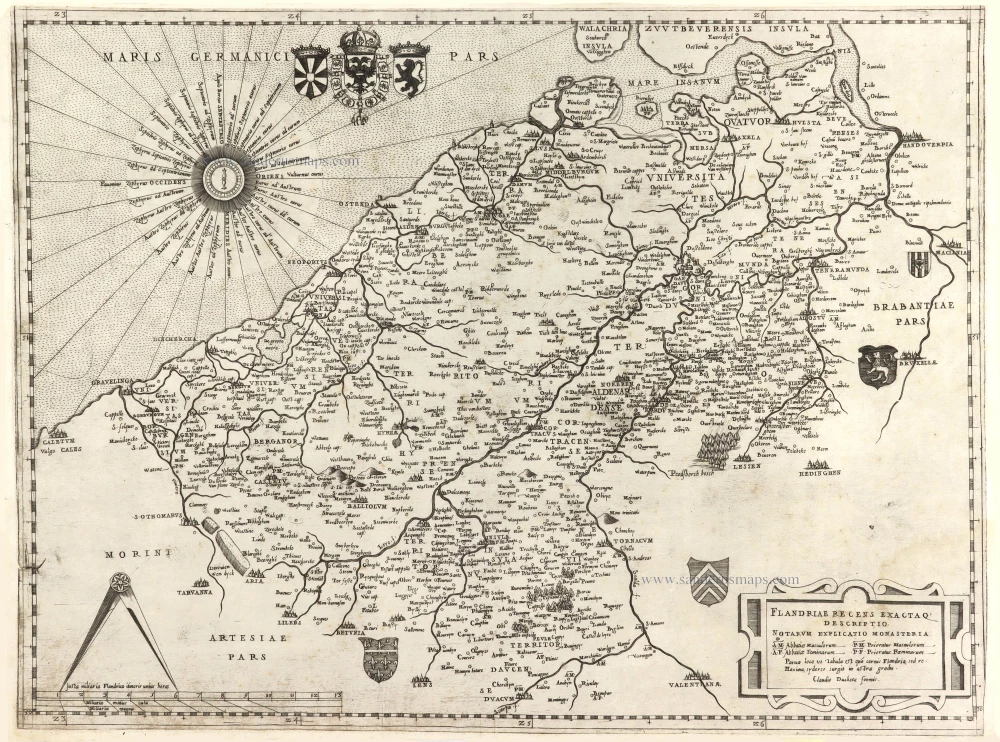
Important and rare map.
Flandriae recens exactaq descriptio. 1555
Flanders, by Michele Tramezzino.
[Item number: 27454]

EXTREMELY RARE FLANDERS MAP BY PIETER VERBIEST
Comitatus Flandria. 1630
Vlaanderen (Flanders), by Pieter Verbiest.
[Item number: 28002]

Le Comté de Flandre divisé en ses Chastellenies, et Balliages, &c. Le Franc de Bruges et Le Pays de Waes. c. 1705
Flanders (Vlaanderen), by Pieter Mortier.
[Item number: 28129]

Celeberrimi Flandriae Comitatus Typus. 1617
Flanders (Vlaanderen) by Petrus Kaerius (Pieter Van den Keere).
[Item number: 28453]
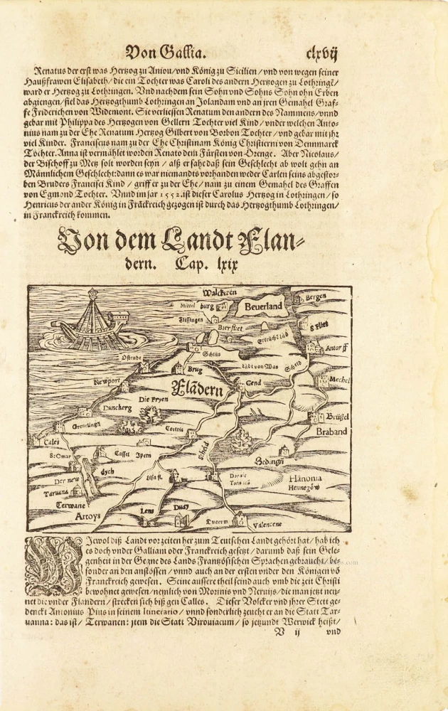
One of the oldest maps of Flanders
Flàdern. [Above map:] Von dem Landt Flandern. 1550
Flanders (Vlaanderen) by Sebastian Münster.
[Item number: 28922]
Rare.
Flandriae recens exactaq descriptio. c. 1570
Flanders, by Claudio Duchetti, after Gerard Mercator.
[Item number: 29729]
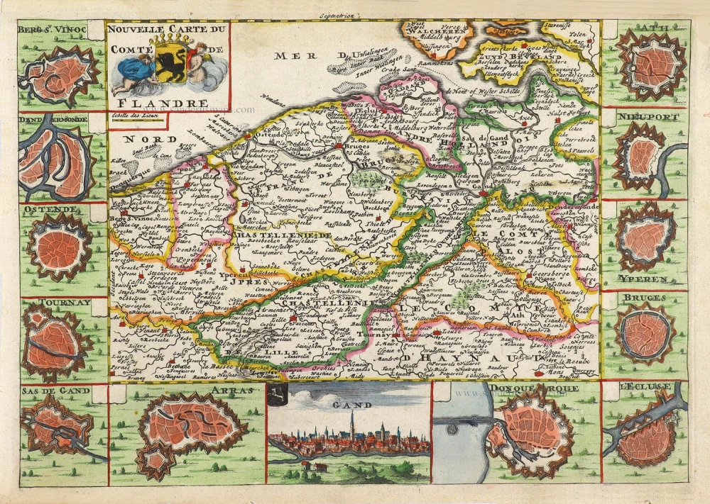
Nouvelle Carte du Comté de Flandre. 1706
Flanders (Vlaanderen) by Daniel De la Feuille.
[Item number: 29889]

Flandriae Comitatus Accuratissima Descriptio. c. 1658
Flanders (Vlaanderen) by Nicolaas Visscher I.
[Item number: 29980]

Rare
Exactissima Flandriae Descriptio. 1593
Flanders (Vlaanderen), by Gerard de Jode.
[Item number: 30309]
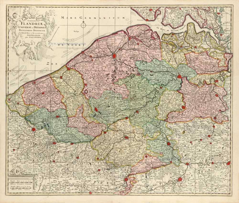
Comitatus Flandriae Universe in Ditiones Peculiares Distinctae. 1730-45
Flanders (Vlaanderen) by Ottens R. & J.
[Item number: 30524]

Very rare!
[No title] c. 1630-1635
Four atlas maps by Henricus Hondius, adapted to form a wall map of Flanders.
[Item number: 31002]

Comitatus Flandriae. 1728
Flanders (Vlaanderen) by G. van Schagen, published by Pieter van der Aa.
[Item number: 31254]
Flandriae Descriptio. 1594
Flanders (Vlaanderen) by Matthias Quad, published by J. Bussemacher.
[Item number: 31256]

Zelandia - Zelandicarum insularum exactissima et nova descriptio, 1592
Zeeland by Matthias Quad, published by J. Bussemacher.
[Item number: 31258]
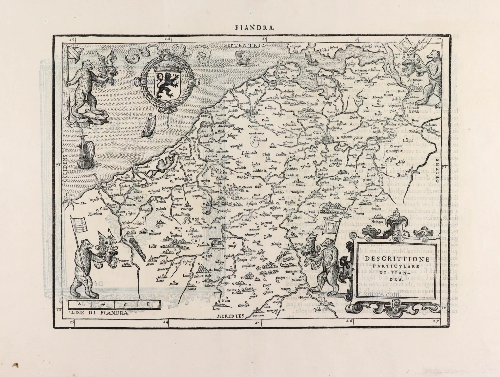
Descrittione Particulare di Fiandra. 1567
Flanders (Vlaanderen) by L. Guicciardini.
[Item number: 31517]
Flandria. 1618
Vlaanderen (Flanders) by Petrus Bertius, published by Jodocus Hondius II.
[Item number: 31592]

Beautiful copy of this important map
Flandria. 1584
Flanders (Vlaanderen), by Abraham Ortelius.
[Item number: 32394]

Comitatus Flandriae in omnes ejusdem subjacentes Ditioescum adjacentibus accuratissime divisus. c. 1720
Flanders (Vlaanderen), by J.B. Homann.
[Item number: 32398]

Novissima Flandriae Comitatus Tabula cum omnibus praefecturis, etc. et Adjacentis Provinciis. 1696-1713
Flanders (Vlaanderen) by Theodore Danckerts.
[Item number: 32497]
The most beautiful 17th-century map of Flanders, with four decorative borders.
Comitatus Flandriae. 1652
Vlaanderen by C.J. Visscher.
[Item number: 33151]
new