
With 'Gravensteen'.
Gent (Castellania) by Antonius Sanderus, published by Joan Blaeu. 1662

Antonius Sanderus (Antwerpen, 1586 – Affligem, 1664)
Antoon Sanders (in Latin Antonius Sanderus) came from a distinguished Ghent family that briefly stayed in Antwerp after temporarily fleeing the Ghent Republic.
Antonius Sanderus, a man of exceptional intellectual prowess, began his Latin studies at the renowned Jesuit college of Oudenaarde and further honed his knowledge in Ghent. His thirst for knowledge led him to pursue philosophy at the Jesuit College of Douai, where he earned a Master's Artium in 1609, a testament to his scholarly dedication.
In 1611, Sanderus was ordained a priest in Ghent and became a pastor in a few hamlets near Eeklo. However, despite the relative calm of the Twelve Years' Truce, the region was not without its tensions. Sanderus found himself in a precarious position due to his controversial writings, which included critiques of Anabaptism in Flanders. These critiques sparked heated debates and raised eyebrows among his peers.
In 1615, he became Baccalaureus in theology at the University of Leuven, and in 1619, he returned to Douai, where he obtained a degree in theology at the University of Douai.
In 1621, he returned to Ghent, where Bishop Antonius Triest protected him. In 1623, he was appointed chaplain and secretary to Cardinal Alfonso de la Cueva, the governor of the Southern Netherlands under Philip IV of Spain.
1625, he became a canon at St. Martin's Church in Ypres.
In the meantime, he conducted extensive research for a prestigious history of the county of Flanders, the Flandria Illustrata. For these searches, he visited monasteries and castles to consult the archives, a testament to his dedication and thoroughness as a historian. However, this meticulous approach to research was not always appreciated by the other canons of Ypres, who felt he was neglecting his other duties.
That is why he resigned from his religious functions in 1654 and was appointed Censor Librorum in Brussels, a position of significant influence in controlling and regulating printed materials. In this role, he played a crucial part in shaping the city's intellectual and cultural life.
In 1668, he resigned as a canon of the Ypres chapter. The reasons for this decision are not entirely clear. Still, it is believed that his increasing focus on his historical research and the offer of a more suitable environment for his work at the Affligem Abbey were contributing factors. Finally, he left the city to settle at the Affligem Abbey, where he was warmly received by the abbot Benedictus van Haeften.
He died there on January 16, 1664, and was buried in the abbey church.
Antonius Sanderus published historical works from 1610, but his magnum opus is the richly illustrated Flandria Illustrata, sive Descriptio Comitatus Istius per Totum Terrarum Orbis Terrarum. The publication was begun by Henricus Hondius, who had a publication contract with Sanderus as early as 1634. It was a landmark in the study of Flanders' history, featuring numerous portraits, plans, views, and maps. In 1641, Hondius published the first volume as the Theatrum Flandriae in Leiden, but immediately sold the rights to Joan Blaeu. They published two volumes of the work in 1641 and 1644, respectively, with a fake publisher's address in Cologne. The work's influence extended beyond its initial publication, with Blaeu using 15 maps from the Flandria Illustrata for his Atlas Maior, and most of the plans were used in the town book of the Royal Netherlands.
In 1659, he published a history of the abbeys and monasteries of Brabant: the Chorographia sacra Brabantiae.
The Blaeus: Willem Janszoon, Cornelis & Joan
Willem Jansz. Blaeu and his son Joan Blaeu are the seventeenth century's most widely known cartographic publishers.
Willem Jansz. (also written Guilielmus Janssonius) = Willem Janszoon Blaeu was born in Uitgeest (Netherlands), near Alkmaar, in 1571. He studied mathematics under Tycho Brahe and learned the theory and practice of astronomical observations and the art of instrument- and globe-making.
In 1596, he came to Amsterdam, where he settled down as a globe-, instrument- and mapmaker. He published his first cartographic work (a globe) in 1599 and probably published his first printed map (a map of the Netherlands) in 1604. He specialised in maritime cartography, published the first edition of the pilot guide Het Licht der Zeevaert in 1608, and was appointed Hydrographer of the V.O.C. (United East India Company) in 1633. After publishing books, wall maps, globes, charts and pilot guides for thirty years, he brought out his first atlas, Atlas Appendix (1630). This was the beginning of the great tradition of atlas-making by the Blaeus.
In 1618, another mapmaker, bookseller and publisher, Johannes Janssonius, established himself in Amsterdam next door to Blaeu's shop. No wonder these two neighbours began accusing each other of copying and stealing their information and became fierce competitors who did not have a good word to say about each other. In about 1621 Willem Jansz. decided to end the confusion between his name and his competitor's and assumed his grandfather's nickname, 'blauwe Willem' ('blue Willem'), as the family name; after that, he called himself Willem Jansz. Blaeu.
Willem Janszoon Blaeu died in 1638, leaving his prospering business to his sons, Cornelis and Joan. We only know that Cornelis's name occurs in the prefaces of books and atlases until c. 1645.
Joan Blaeu, born in Amsterdam in 1596, became a partner in his father's book trade and printing business. 1638, he was appointed his father's successor in the Hydrographic Office of the V.O.C. His efforts culminated in the magnificent Atlas Major and the town books of the Netherlands and Italy – works unsurpassed in history and modern times, giving eternal fame to the name of the Blaeu's.
A fire ruined the business on February 23, 1672, and one year later, Dr. Joan Blaeu died. The fire and the director's passing caused the complete sale of the Blaeu House's stock. Five public auctions dispersed the remaining books, atlases, copperplates, globes, etc., among many other map dealers and publishers in Amsterdam. The majority was acquired by several booksellers acting in partnership.
In the succeeding years, the remaining printing department remained in the hands of the Blaeu family until 1695, when the printing house's inventory was sold at a public auction. That meant the end of the Blaeu family as a printing house of world renown.
... Hanc Veteris Burgis novam tabulam ...
Item Number: 28138 Authenticity Guarantee
Category: Antique maps > Europe > Belgium
Old, antique map of the vicinity of Ghent (Gent - Castellania) by A. Sanderus, published by J. Blaeu.
Oude, antieke kaart van de Casselrij van de Oudburg van Gent door A. Sanderus, uitgegeven door J. Blaeu.
With inset: Veerleplein + Gravenkasteel.
Title: ... Hanc Veteris Burgis novam tabulam ...
Dedicated to Georgius de la Faille by Joan and Cornelis Blaeu.
Date of the first edition: 1641 (Flandria Illustrata)
Date of this map: 1662.
Copper engraving, printed on paper.
Size (not including margins): 415 x 495mm (16.34 x 19.49 inches).
Verso: Latin text.
Condition: Original coloured, excellent.
Condition Rating: A+.
References: Van der Krogt 2, 3231:2; De Vleesschauwer, #104
From: Atlas Maior, Sive Cosmographia Blaviana, Qua Solum, Salum, Coelum, Accuratissime Describuntur. - Geographiae Blavianae Volumen Quartum, quo Lib. IX, X, Europae Continentur. Amsterdam, J. Blaeu, 1662. (Van der Krogt 2, 601-3.4)
Antonius Sanderus (Antwerpen, 1586 – Affligem, 1664)
Antoon Sanders (in Latin Antonius Sanderus) came from a distinguished Ghent family that briefly stayed in Antwerp after temporarily fleeing the Ghent Republic.
Antonius Sanderus, a man of exceptional intellectual prowess, began his Latin studies at the renowned Jesuit college of Oudenaarde and further honed his knowledge in Ghent. His thirst for knowledge led him to pursue philosophy at the Jesuit College of Douai, where he earned a Master's Artium in 1609, a testament to his scholarly dedication.
In 1611, Sanderus was ordained a priest in Ghent and became a pastor in a few hamlets near Eeklo. However, despite the relative calm of the Twelve Years' Truce, the region was not without its tensions. Sanderus found himself in a precarious position due to his controversial writings, which included critiques of Anabaptism in Flanders. These critiques sparked heated debates and raised eyebrows among his peers.
In 1615, he became Baccalaureus in theology at the University of Leuven, and in 1619, he returned to Douai, where he obtained a degree in theology at the University of Douai.
In 1621, he returned to Ghent, where Bishop Antonius Triest protected him. In 1623, he was appointed chaplain and secretary to Cardinal Alfonso de la Cueva, the governor of the Southern Netherlands under Philip IV of Spain.
1625, he became a canon at St. Martin's Church in Ypres.
In the meantime, he conducted extensive research for a prestigious history of the county of Flanders, the Flandria Illustrata. For these searches, he visited monasteries and castles to consult the archives, a testament to his dedication and thoroughness as a historian. However, this meticulous approach to research was not always appreciated by the other canons of Ypres, who felt he was neglecting his other duties.
That is why he resigned from his religious functions in 1654 and was appointed Censor Librorum in Brussels, a position of significant influence in controlling and regulating printed materials. In this role, he played a crucial part in shaping the city's intellectual and cultural life.
In 1668, he resigned as a canon of the Ypres chapter. The reasons for this decision are not entirely clear. Still, it is believed that his increasing focus on his historical research and the offer of a more suitable environment for his work at the Affligem Abbey were contributing factors. Finally, he left the city to settle at the Affligem Abbey, where he was warmly received by the abbot Benedictus van Haeften.
He died there on January 16, 1664, and was buried in the abbey church.
Antonius Sanderus published historical works from 1610, but his magnum opus is the richly illustrated Flandria Illustrata, sive Descriptio Comitatus Istius per Totum Terrarum Orbis Terrarum. The publication was begun by Henricus Hondius, who had a publication contract with Sanderus as early as 1634. It was a landmark in the study of Flanders' history, featuring numerous portraits, plans, views, and maps. In 1641, Hondius published the first volume as the Theatrum Flandriae in Leiden, but immediately sold the rights to Joan Blaeu. They published two volumes of the work in 1641 and 1644, respectively, with a fake publisher's address in Cologne. The work's influence extended beyond its initial publication, with Blaeu using 15 maps from the Flandria Illustrata for his Atlas Maior, and most of the plans were used in the town book of the Royal Netherlands.
In 1659, he published a history of the abbeys and monasteries of Brabant: the Chorographia sacra Brabantiae.
The Blaeus: Willem Janszoon, Cornelis & Joan
Willem Jansz. Blaeu and his son Joan Blaeu are the seventeenth century's most widely known cartographic publishers.
Willem Jansz. (also written Guilielmus Janssonius) = Willem Janszoon Blaeu was born in Uitgeest (Netherlands), near Alkmaar, in 1571. He studied mathematics under Tycho Brahe and learned the theory and practice of astronomical observations and the art of instrument- and globe-making.
In 1596, he came to Amsterdam, where he settled down as a globe-, instrument- and mapmaker. He published his first cartographic work (a globe) in 1599 and probably published his first printed map (a map of the Netherlands) in 1604. He specialised in maritime cartography, published the first edition of the pilot guide Het Licht der Zeevaert in 1608, and was appointed Hydrographer of the V.O.C. (United East India Company) in 1633. After publishing books, wall maps, globes, charts and pilot guides for thirty years, he brought out his first atlas, Atlas Appendix (1630). This was the beginning of the great tradition of atlas-making by the Blaeus.
In 1618, another mapmaker, bookseller and publisher, Johannes Janssonius, established himself in Amsterdam next door to Blaeu's shop. No wonder these two neighbours began accusing each other of copying and stealing their information and became fierce competitors who did not have a good word to say about each other. In about 1621 Willem Jansz. decided to end the confusion between his name and his competitor's and assumed his grandfather's nickname, 'blauwe Willem' ('blue Willem'), as the family name; after that, he called himself Willem Jansz. Blaeu.
Willem Janszoon Blaeu died in 1638, leaving his prospering business to his sons, Cornelis and Joan. We only know that Cornelis's name occurs in the prefaces of books and atlases until c. 1645.
Joan Blaeu, born in Amsterdam in 1596, became a partner in his father's book trade and printing business. 1638, he was appointed his father's successor in the Hydrographic Office of the V.O.C. His efforts culminated in the magnificent Atlas Major and the town books of the Netherlands and Italy – works unsurpassed in history and modern times, giving eternal fame to the name of the Blaeu's.
A fire ruined the business on February 23, 1672, and one year later, Dr. Joan Blaeu died. The fire and the director's passing caused the complete sale of the Blaeu House's stock. Five public auctions dispersed the remaining books, atlases, copperplates, globes, etc., among many other map dealers and publishers in Amsterdam. The majority was acquired by several booksellers acting in partnership.
In the succeeding years, the remaining printing department remained in the hands of the Blaeu family until 1695, when the printing house's inventory was sold at a public auction. That meant the end of the Blaeu family as a printing house of world renown.
Related items

Vue de l'Entrépôt Général de Libre Réexportation en Construction à Gand 1844. c. 1850
Ghent (Gent) by Charles Le Clerc, after Louis Roelandt.
[Item number: 5604]

Ghendt. 1613
Gent by Ludovico Guicciardini.
[Item number: 29558]

Ghent. 1833
Ghent (Gent) Three towers - Drie torens, by S. Prout.
[Item number: 30027]

Extremely rare map of Ghent and surroundings.
Praenobili Magnifico Amplissimoq[ue] Magistratui inclytae civitatis Gandavensis
Ghent (Gent), by Henricus Hondius.
[Item number: 30121]
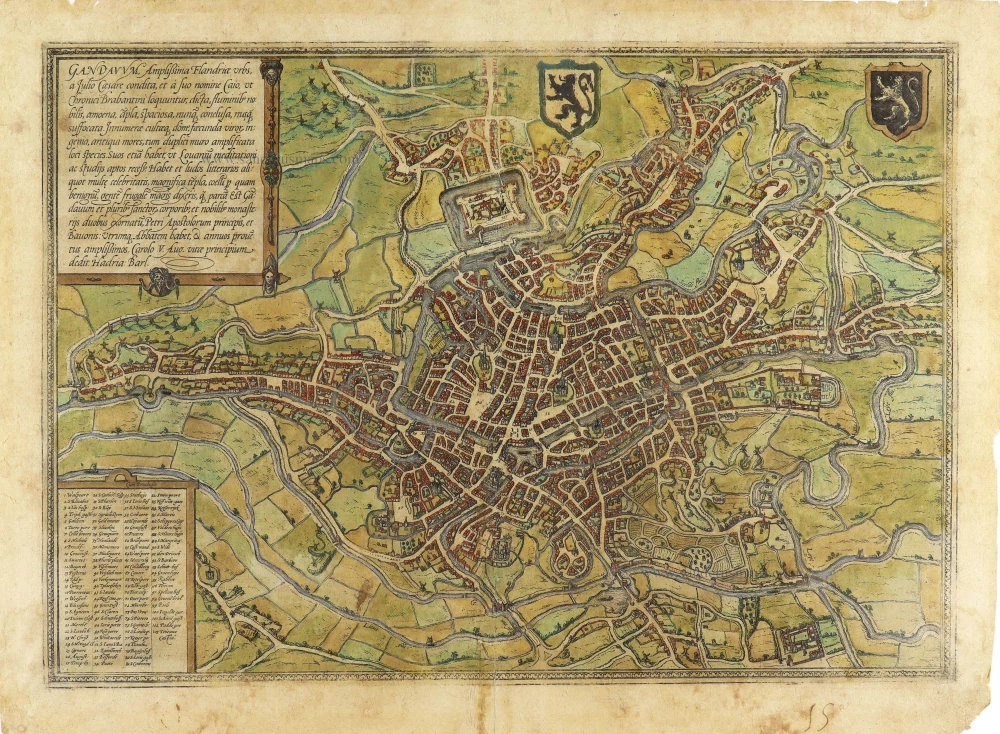
Gandavum, Amplissima Flandriae urbs, ... 1599
Gent by Georg Braun & Frans Hogenberg.
[Item number: 31325]
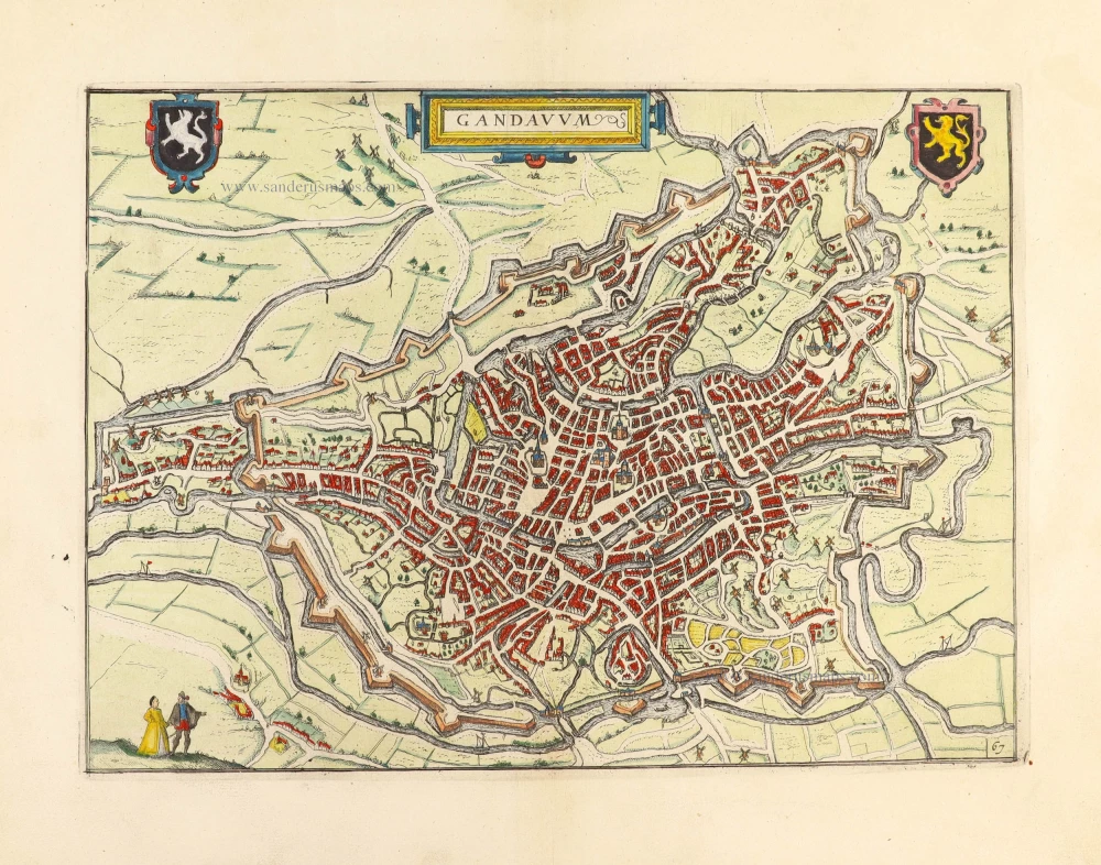
Gandavum. 1612
Gent by Lodovico Guicciardini.
[Item number: 31373]

Gandavum vulgo Gent. 1641
Gent (Ghent) by Antonius Sanderus.
[Item number: 31606]

Curia Antiqua Gandavensis - Curia Nova Gandavensis 1641
Oude gotische en het nieuwe renaissance stadhuis van Gent, door Antonius Sanderus.
[Item number: 31608]

Ecclesia Collegiata Divi Pharahildis. - Petra Comitis vulgo Het Graven Casteel. 1641
Gent - Gravenkasteel en omgeving door Antonius Sanderus.
[Item number: 31609]

Macellum maius cum foro Piscario. 1641
Gent - Vleeshalle en Vismarkt door Antonius Sanderus.
[Item number: 31610]

Ecclesia Divo Ioanni Baptistae Sacra. 1641
Gent - St.-Baafskathedraal door Antonius Sanderus.
[Item number: 31612]

Praetorium Reverendißimi ac perillistris Domini Dñi Antonii Triest Episcopi Gandavensis, in agro Paraeciae Ackergemiensis, vulgo Belvedere. 1641
Gent - Akkergem - Kasteel Belvedere, door Antonius Sanderus.
[Item number: 31614]

Forum Veneris Vulgo De Vrydach Maert et Ecclesia S. Iacobi. - Ecclesia Parochialis Sti Nicolai. Iuxta forum frumentarium Gandavi. 1641
Gent - Vrijdagmarkt & St.-Jacobskerk - Korenmarkt & St.-Niklaaskerk, door Antonius Sanderus.
[Item number: 31615]

Nova Cartusiae Vallis Regalis intra terminos civitatis Gandavensis delin. 1641
Gent - Kartuizerklooster Koningsdal, door Antonius Sanderus.
[Item number: 31622]
![Gent - Kouter en St.-Sebastiaanshof [Verso:] Gildehuis St.-Joris, door Antonius Sanderus.](https://sanderusmaps.com/assets/IMG/webp/m31623.webp)
Hippodromus Gandavensis cum adiacentibus aedificiis et Aula Sti Sebastiani. [Verso:] Domus Gildae S. Georgii Vulgo St Ioris Hoff 1641
Gent - Kouter en St.-Sebastiaanshof [Verso:] Gildehuis St.-Joris, door Antonius Sanderus.
[Item number: 31623]

Gandavum vulgo Gent. 1649
Gent by Joan Blaeu.
[Item number: 32006]

With train station
Panorama von Gent / Panorama de Gand.. c. 1840
Ghent, by F.C. Eisen.
[Item number: 32083]

Rare city plan
Plan de la ville de Gand et de ses Faubourgs. 1830
Gent by M. Delhoungne. (Ghent)
[Item number: 32618]