
Rare city plan
Gent by M. Delhoungne. (Ghent) 1830

According to Dejardin, this scarce plan of Ghent was made by the Dutch engineering troops and published by M. Delhoungne. Later, it was copied by Tessaro in 1839 and 1851. He knows of two copies of this plan, one in the collection of P.-J. Goetghebuer and one in the Bibl. du Dépôt de la Guerre in Brussels.
Plan de la ville de Gand et de ses Faubourgs.
Item Number: 32618 Authenticity Guarantee
Category: Antique maps > Europe > Belgium - Cities
Plan of Ghent (Gent), published by M. Delhoungne.
Title: Plan de la ville de Gand et de ses Faubourgs.
Dressé d'après de nouveaux matériaux.
Revus pour les détails topographiques et les changemens jusqu'en 1830.
Oriented to the northeast.
Date: 1830.
Date on map: 1830.
Image size: 475 x 590mm (18¾ x 23¼ inches).
Sheet size: 490 x 605mm (19¼ x 23¾ inches).
Condition: Old folds, holes at the intersection of the folds, a few tears and a hole (1x2cm) backed.
Condition Rating: A
Separate publication.
According to Dejardin, this scarce plan of Ghent was made by the Dutch engineering troops and published by M. Delhoungne. Later, it was copied by Tessaro in 1839 and 1851. He knows of two copies of this plan, one in the collection of P.-J. Goetghebuer and one in the Bibl. du Dépôt de la Guerre in Brussels.
Related items

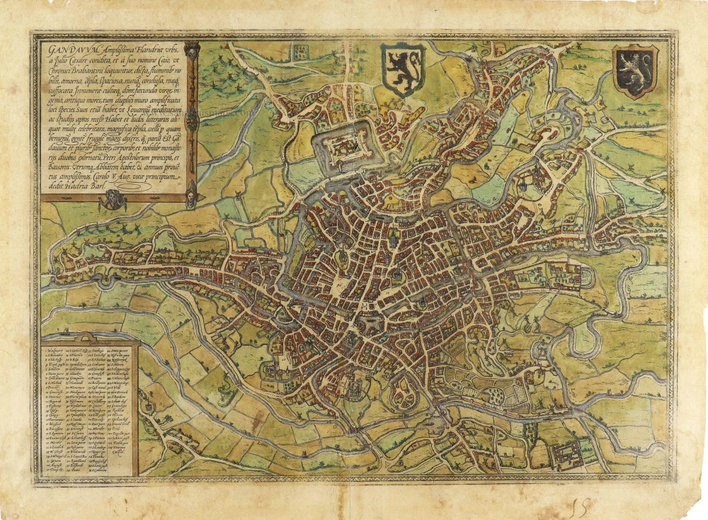
Gandavum, Amplißima Flandria Urbs ... 1657
Ghent (Gent) by Georg Braun & Frans Hogenberg, published by Johannes Janssonius.
[Item number: 2687]
Rare!
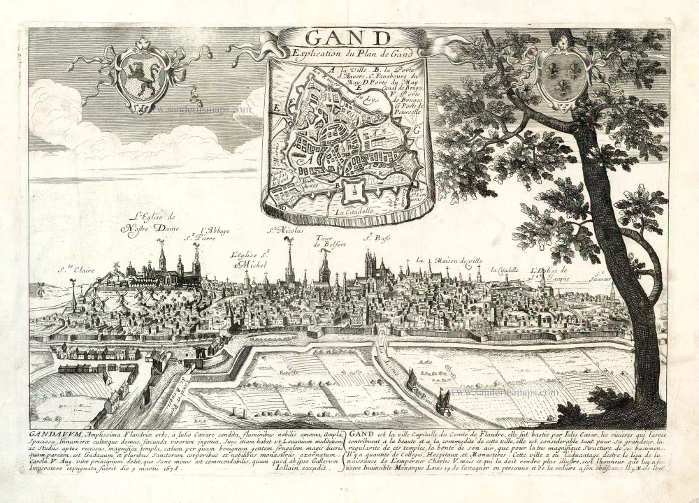
Gand. c. 1678
Ghent by Gerard Jollain. (Gent)
[Item number: 26705]

Plan du siège et des attaques de la ville et citadelle de Gand assiégée par les armées des alliez le 22 décembre 1708. ... 1729
Gent, by Jean Dumont.
[Item number: 27430]

With 'Gravensteen'.
... Hanc Veteris Burgis novam tabulam ... 1662
Gent (Castellania) by Antonius Sanderus, published by Joan Blaeu.
[Item number: 28138]
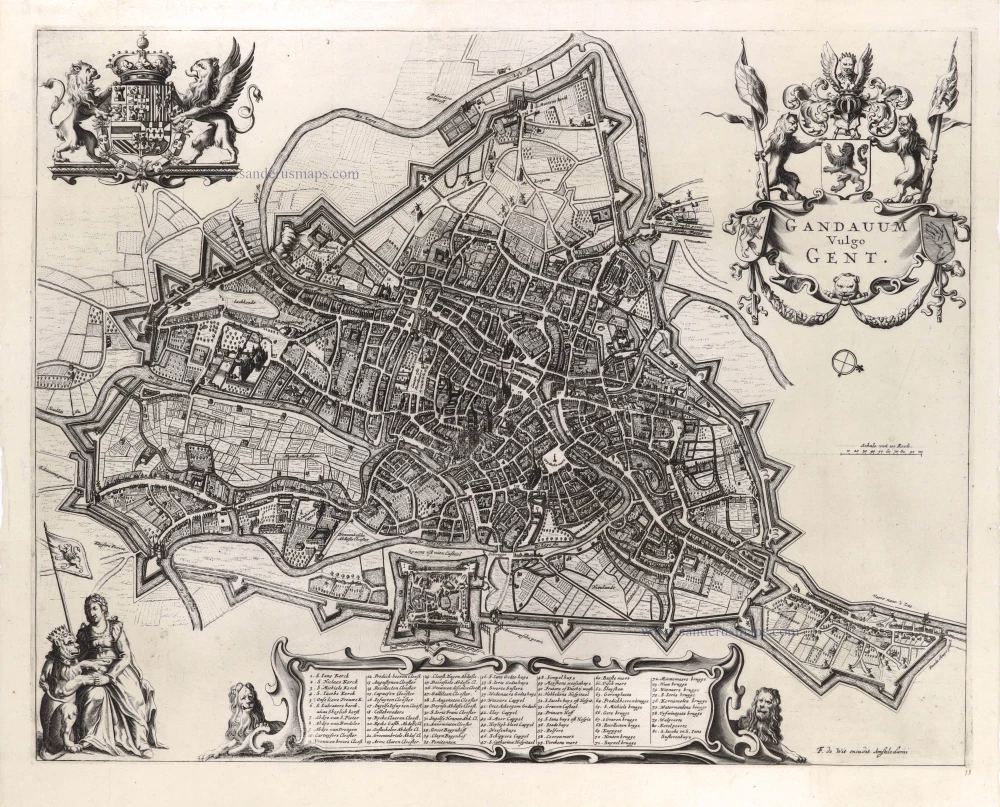
Gandavum vulgo Gent. c. 1700
Gent by Frederick de Wit.
[Item number: 29517]

Ghendt. 1613
Gent by Ludovico Guicciardini.
[Item number: 29558]

Plan du siège et des attaques de la ville et citadelle de Gand assiégée par les armées des alliez le 22 décembre 1708. ... 1729
Gent, by Jean Dumont.
[Item number: 29849]
Gandavum, Amplissima Flandriae urbs, ... 1599
Gent by Georg Braun & Frans Hogenberg.
[Item number: 31325]

Gandavum vulgo Gent. 1641
Gent (Ghent) by Antonius Sanderus.
[Item number: 31606]

Gandavum vulgo Gent. 1649
Gent by Joan Blaeu.
[Item number: 32006]

Exceptional beautiful colour
Gandavum, Amplissima Flandriae urbs, ... 1693
Gent by Georg Braun & Frans Hogenberg.
[Item number: 32474]