
Important and rare map.
Brabant, by Michele Tramezini. 1558

Rare map in its second state, copied first in 1556 by Jacobus Bossius and Michele Tramezini after the Brabant map of 1536 by Jacob van Deventer. He made a set of maps of the five provinces of the Northern Netherlands, of which no copies are known. The first editions were made in Antwerp 1556-1560, followed by the adaptions published by Tramezini, whose series in turn were later copied by Forlani.
Michele Tramezzino (15?? – 1579)
Venetian printer and publisher with two workshops, one in Rome with his brother Francesco and one in Venice ‘all Insegna della Sibille’.
Both brothers, Michele and Francesco were born in Rome, although the family took refuge in Venice in 1527, fleeing the sack of Rome. Francesco returned to Rome, and Michele remained in Venice. The brothers have been printing maps, stamps and literary, historical and legal works since 1551. Their production was very copious and was always accompanied by a typographic mark that represented the figure of the Sibyl.
In 1554, Michele Tramezzino published a world map which stands on its own as a masterpiece of Renaissance cartography.
Brabantiae Belgarum Provinciae Recens Exactaque Descriptio.
Item Number: 26713 Authenticity Guarantee
Category: Antique maps > Europe > Belgium
Old, antique map of Brabant, by Michele Tramezini.
Oude, antieke kaart van Brabant, door Michele Tramezini.
Cartographer: Jacob van Deventer
Engraver: Jacobus Bossius
Date of the first edition: 1556
Date of this map: 1558
Date on map: 1558
Copper engraving, printed on paper.
Size (not including margins): 52 x 39.5cm (20.3 x 15.4 inches)
Verso: Blank
Condition: Somewhat dusty, backed with paper.
Condition Rating: A
References: Bifolco-Ronca, Tav.280 State 2; Tooley (Italian Atlases), #143; Karrow, 25/1.2; Meurer (Strabo), #12; Dorigo-Franssen (Brabant), #4.2 .
Separate publication. - Probably from a composite Lafreri Atlas.
Rare map in its second state, copied first in 1556 by Jacobus Bossius and Michele Tramezini after the Brabant map of 1536 by Jacob van Deventer. He made a set of maps of the five provinces of the Northern Netherlands, of which no copies are known. The first editions were made in Antwerp 1556-1560, followed by the adaptions published by Tramezini, whose series in turn were later copied by Forlani.
Rare map in its second state, copied first in 1556 by Jacobus Bossius and Michele Tramezini after the Brabant map of 1536 by Jacob van Deventer. He made a set of maps of the five provinces of the Northern Netherlands, of which no copies are known. The first editions were made in Antwerp 1556-1560, followed by the adaptions published by Tramezini, whose series in turn were later copied by Forlani.
Michele Tramezzino (15?? – 1579)
Venetian printer and publisher with two workshops, one in Rome with his brother Francesco and one in Venice ‘all Insegna della Sibille’.
Both brothers, Michele and Francesco were born in Rome, although the family took refuge in Venice in 1527, fleeing the sack of Rome. Francesco returned to Rome, and Michele remained in Venice. The brothers have been printing maps, stamps and literary, historical and legal works since 1551. Their production was very copious and was always accompanied by a typographic mark that represented the figure of the Sibyl.
In 1554, Michele Tramezzino published a world map which stands on its own as a masterpiece of Renaissance cartography.
Related items
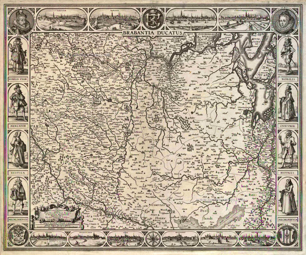
Brabantia Ducatus / Tabula Ducatus Brabantiae Continens Marchionatum Sacri Imperij et Dominium Mechliniense Magna cura edita à Nicolao Iohannis Visscher. Anno 1622. 1622
Brabant by C.J. Visscher.
[Item number: 2640]

Brabantiae Descriptio 1601
Brabant, with an inset map of the district of Mechelen, by Abraham Ortelius.
[Item number: 12909]
Ducatus Brabantiae. 1631
Brabant by Abraham Goos,published by Joannes Janssonius.
[Item number: 17723]

Novissima et Accuratissima Brabantiae Ducatus Tabula. 1638
Brabant by Henricus Hondius, published by J. Janssonius.
[Item number: 19012]

Brabantia Ducatus 1664-65
Brabant by Willem Blaeu
[Item number: 20955]

Brabantiae Belgarum provinciae recens exactaque descriptio. 1602
Brabant by M. Quad - J. Bussemacher.
[Item number: 25235]

Brabantiae Descriptio. 1595
Brabant, by A. Ortelius.
[Item number: 25573]
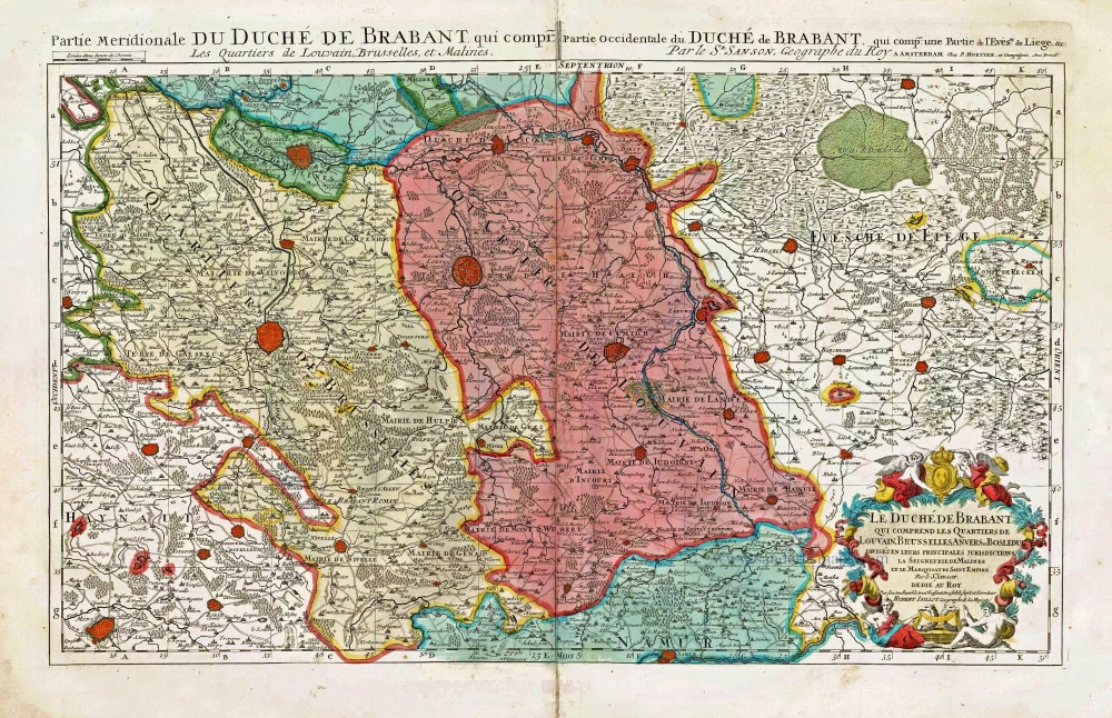
Le Duché de Brabant qui comprend les Quartiers de Louvain, Brusselles, Anvers et Bosleduc diviséz en leurs Principales Jurisdictions, La Seigneurie de Malines et le Marquisat du Saint Empire. c. 1705
Southern Brabant, by Pieter Mortier.
[Item number: 27801]

Brabantia Ducatus Machliniae Urbis Dominium. 1617
The Duchy of Brabant by Pieter van den Keere (Petrus Kaerius).
[Item number: 28672]

First edition, woodcut
Descrittione particulare di Brabante. 1567
Brabant by Lodovico Guicciardini.
[Item number: 29504]

Le Brabant Hollandois et Autrichien. 1747
Northwest Brabant by G.L. Le Rouge.
[Item number: 30255]
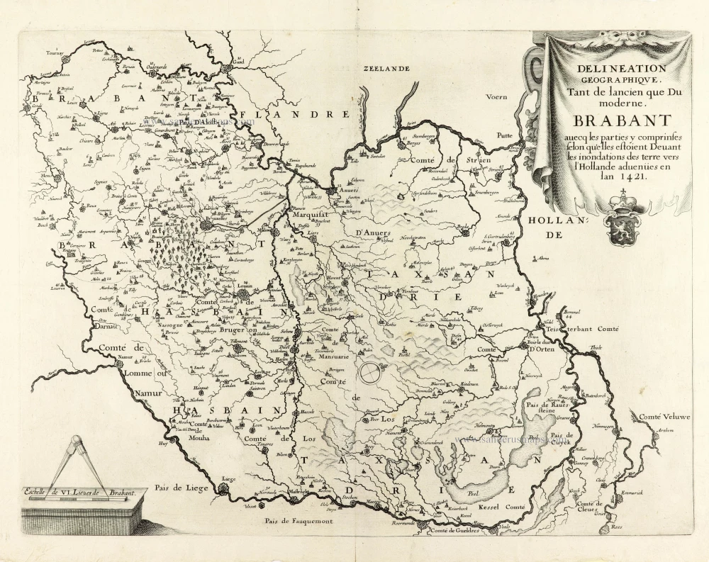
Very rare first state.
Delineation Geographique. Tant de lancien que Du moderne. Brabant avecq les parties y comprinses selon qu'elles estoient Devant les inondations des terre vers l'Hollande advenües en lan 1421. 1637
Historical map of Brabant by Christophe Butkens.
[Item number: 30291]

Partie Septentrionale du Duché de Brabant où se trouvent les Mairies de Bosleduc de Turnhout, de Santhoven, d'Herentals, les Marquisats de Berg-op-Zoom, et du St Empire, la Baronie de Bréda partie de la Seigneurie de Malines, et de l'Evêché de Lyége &c. 1757
Southern Brabant par Robert de Vaugondy.
[Item number: 30403]

Menapii. Dioecese de l'Archev[es]ché de Malines. Partie meridionale du Duché de Brabant, ou sont les quartiers de Louvain, et du Brusselles; et la seign[eu]rie de Malines. 1679-1710
Historical map of Southern Brabant, by Guillaume Sanson, published by P. Mariette.
[Item number: 30520]

Tabula Ducatus Brabantiae continens Marchionatum Sacri Imperiii et Dominium Mechliniense 1670-71
Brabant by Frederick De Wit.
[Item number: 30526]

[No Title] 1630
Brabant by Gerard Mercator.
[Item number: 30943]

Brabantia. 1618
Brabant by Petrus Bertius, published by Jodocus Hondius II.
[Item number: 31591]

Le Duché de Brabant qui comprend les quartiers de Louvan, Brusselles, Anvers et Bos le Duc 1692
Northern Brabant, by N. Sanson, so-called published by Hubert Jaillot. (Pirated edition by Pierre Mortier).
[Item number: 31721]

Carte de Brabant. 1633
Brabant by Chistophe Tassin.
[Item number: 31930]

Ducatus Brabantiae Nova Tabula in qua Lovanii Bruxxellarum March S. Imperii Sylvae Ducis et Mechliniae Dominia in sua suasq. minores Ditiones subdivisa ostenduntur. c. 1720
Brabant, by J.B. Homann.
[Item number: 32467]

Ducatus Brabantiae Tabula continens Sacri Imperii Marchionatum et Dominium Mechliniense de novo accurate emendata. c. 1704-1706
Brabant by Johannes Danckerts.
[Item number: 32498]