
Scarce.
Arctic Region by Petrus Bertius. 1618

Very rare. This small Bertius atlas appeared only twice.
In 1616 a new engraved series of plates were made for the editions of Bertius's Tabulae Geographicae Contractae, to be published by Jodocus Hondius Jr.
Petrus Bertius, the cosmographer of Louis XIII of France, was influenced by the king's desire to write a French text for the popular Tabularum Geographicarum. Bertius followed the Latin text of the edition of 1616.
Petrus Bertius (1565-1629)
Petrus Bertius, born at Beveren, Flanders, in 1565, was related to Pieter van den Keere (Kaerius) and Jodocus Hondius. Both famous cartographers were brothers-in-law of Petrus Bertius. As a refugee, he settled in Amsterdam, and after finishing his studies, he became a professor of mathematics and librarian at the University of Leiden. In 1618, he became a cosmographer and historiographer for Louis XIII of France. He lived in Paris, where he died in 1629.
Petrus Bertius's remarkable work ethic is evident in the numerous geographical and theological works he produced. His contributions to the works of Clüver and Herrera further solidified his reputation in geography.
His fame among geographers was established by his text in the pocket atlas Tabularum Geographicarum and by his edition of Ptolemy’s Geographia.
The origin of the Tabularum Geographicum lies in the well-known miniature atlas Caert thresoor, published by Barent Langenes in 1598 in Middelburg. Bertius engraved 169 maps for this small but attractive atlas, sold for the first time in 1599 by Cornelis Claesz in Amsterdam. In 1600, Claesz published the pocket atlas with a Latin text composed by Petrus Bertius. From then on, new editions, often enlarged with new maps, regularly appeared, subsequently published by Cornelis Claesz, Jodocus Hondius, Johannes Janssonius and ultimately, in 1649, by Claes Jansz. Visscher.
Koeman divides this series of pocketbooks into two atlases: The Caert-thresoor, published by Langenes and Claesz., with five editions between 1598 and 1609, and the Tabularum Geographicarum Contractarum by Petrus Bertius with ten editions between 1600 and 1650.
[Title above map:] La Description des Hyperborees.
Item Number: 28390 Authenticity Guarantee
Category: Antique maps > Europe > Northern Europe
Old, antique map of Arctic Region, by Bertius Petrus.
[Title above map:] La Description des Hyperborees.
Cartographer: Gerard Mercator.
Date of the first edition: 1616.
Date of this map: 1618.
Copper engraving, printed on paper.
Map size: 95 x 120mm (3.74 x 4.72 inches).
Sheet size: 120 x 180mm (4.72 x 7.09 inches).
Verso: French text.
Condition: Excellent.
Condition Rating: A+.
References: Van der Krogt 3, 0020:342; Burden, #184
From: La Geographie Racourcie de Pierre Bertius. Amsterdam, Jodocus Hondius jr. 1618. (Van der Krogt 3, 342:11)
Very rare. This small Bertius atlas appeared only twice.
In 1616 a new engraved series of plates were made for the editions of Bertius's Tabulae Geographicae Contractae, to be published by Jodocus Hondius Jr.
Petrus Bertius, the cosmographer of Louis XIII of France, was influenced by the king's desire to write a French text for the popular Tabularum Geographicarum. Bertius followed the Latin text of the edition of 1616.
Petrus Bertius (1565-1629)
Petrus Bertius, born at Beveren, Flanders, in 1565, was related to Pieter van den Keere (Kaerius) and Jodocus Hondius. Both famous cartographers were brothers-in-law of Petrus Bertius. As a refugee, he settled in Amsterdam, and after finishing his studies, he became a professor of mathematics and librarian at the University of Leiden. In 1618, he became a cosmographer and historiographer for Louis XIII of France. He lived in Paris, where he died in 1629.
Petrus Bertius's remarkable work ethic is evident in the numerous geographical and theological works he produced. His contributions to the works of Clüver and Herrera further solidified his reputation in geography.
His fame among geographers was established by his text in the pocket atlas Tabularum Geographicarum and by his edition of Ptolemy’s Geographia.
The origin of the Tabularum Geographicum lies in the well-known miniature atlas Caert thresoor, published by Barent Langenes in 1598 in Middelburg. Bertius engraved 169 maps for this small but attractive atlas, sold for the first time in 1599 by Cornelis Claesz in Amsterdam. In 1600, Claesz published the pocket atlas with a Latin text composed by Petrus Bertius. From then on, new editions, often enlarged with new maps, regularly appeared, subsequently published by Cornelis Claesz, Jodocus Hondius, Johannes Janssonius and ultimately, in 1649, by Claes Jansz. Visscher.
Koeman divides this series of pocketbooks into two atlases: The Caert-thresoor, published by Langenes and Claesz., with five editions between 1598 and 1609, and the Tabularum Geographicarum Contractarum by Petrus Bertius with ten editions between 1600 and 1650.
Related items
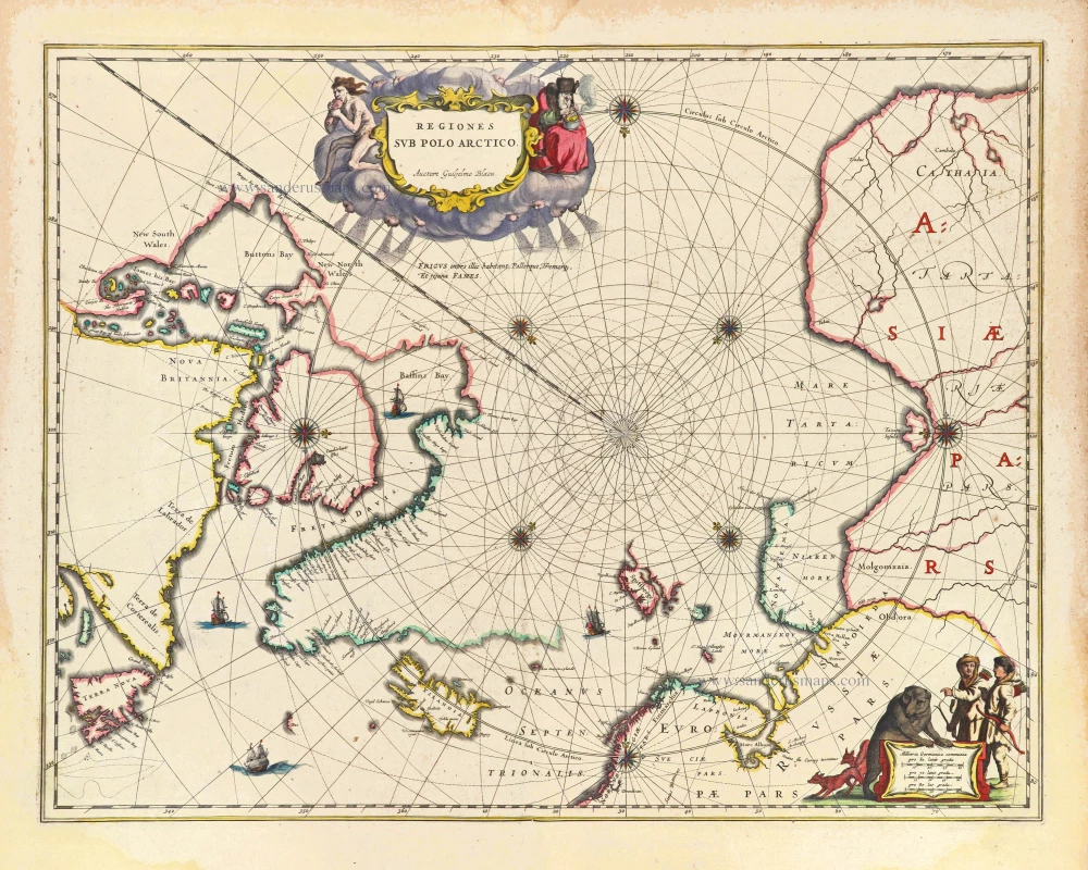
Regiones sub Polo Arctico. 1643
Arctic Region, by Joan Blaeu
[Item number: 29447]

Very rare first state of Mercator's North Pole map.
Septentrionalium Terrarum descriptio. 1595
Arctic Region - North Pole by Gerard Mercator, first state published by Rumold Mercator.
[Item number: 29799]