
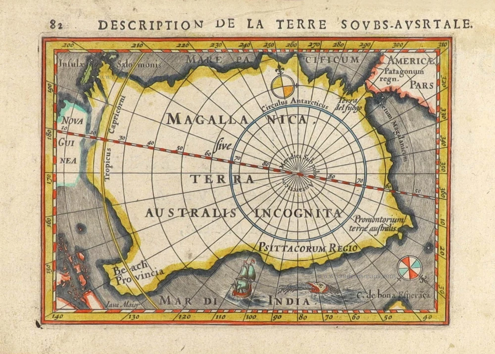
Antartic Region by Petrus Bertius. 1616
Petrus Bertius (1565-1629)
Petrus Bertius, born at Beveren, Flanders, in 1565, was related to Pieter van den Keere (Kaerius) and Jodocus Hondius. Both famous cartographers were brothers-in-law of Petrus Bertius. As a refugee, he settled in Amsterdam, and after finishing his studies, he became a professor of mathematics and librarian at the University of Leiden. In 1618, he became a cosmographer and historiographer for Louis XIII of France. He lived in Paris, where he died in 1629.
Petrus Bertius's remarkable work ethic is evident in the numerous geographical and theological works he produced. His contributions to the works of Clüver and Herrera further solidified his reputation in geography.
His fame among geographers was established by his text in the pocket atlas Tabularum Geographicarum and by his edition of Ptolemy’s Geographia.
The origin of the Tabularum Geographicum lies in the well-known miniature atlas Caert thresoor, published by Barent Langenes in 1598 in Middelburg. Bertius engraved 169 maps for this small but attractive atlas, sold for the first time in 1599 by Cornelis Claesz in Amsterdam. In 1600, Claesz published the pocket atlas with a Latin text composed by Petrus Bertius. From then on, new editions, often enlarged with new maps, regularly appeared, subsequently published by Cornelis Claesz, Jodocus Hondius, Johannes Janssonius and ultimately, in 1649, by Claes Jansz. Visscher.
Koeman divides this series of pocketbooks into two atlases: The Caert-thresoor, published by Langenes and Claesz., with five editions between 1598 and 1609, and the Tabularum Geographicarum Contractarum by Petrus Bertius with ten editions between 1600 and 1650.
Magallanica sive Terra Australis Incognita. [Title in map]
Item Number: 29797 Authenticity Guarantee
Category: Antique maps > Australia
Old, antique map of the Antartic Region by Petrus Bertius.
Title: Magallanica sive Terra Australis Incognita. [Title in map]
Date of the first edition: 1616.
Date of this map: 1616.
Copper engraving, printed on paper.
Image size: 95 x 135mm (3.74 x 5.31 inches).
Sheet size: 120 x 180mm (4.72 x 7.09 inches).
Verso: French text.
Condition: Hand coloured, excellent.
Condition Rating: A+.
From: La Geographie Recourcie de Pierre Bertius. Amsterdam, J. Hondius, 1616.
Petrus Bertius (1565-1629)
Petrus Bertius, born at Beveren, Flanders, in 1565, was related to Pieter van den Keere (Kaerius) and Jodocus Hondius. Both famous cartographers were brothers-in-law of Petrus Bertius. As a refugee, he settled in Amsterdam, and after finishing his studies, he became a professor of mathematics and librarian at the University of Leiden. In 1618, he became a cosmographer and historiographer for Louis XIII of France. He lived in Paris, where he died in 1629.
Petrus Bertius's remarkable work ethic is evident in the numerous geographical and theological works he produced. His contributions to the works of Clüver and Herrera further solidified his reputation in geography.
His fame among geographers was established by his text in the pocket atlas Tabularum Geographicarum and by his edition of Ptolemy’s Geographia.
The origin of the Tabularum Geographicum lies in the well-known miniature atlas Caert thresoor, published by Barent Langenes in 1598 in Middelburg. Bertius engraved 169 maps for this small but attractive atlas, sold for the first time in 1599 by Cornelis Claesz in Amsterdam. In 1600, Claesz published the pocket atlas with a Latin text composed by Petrus Bertius. From then on, new editions, often enlarged with new maps, regularly appeared, subsequently published by Cornelis Claesz, Jodocus Hondius, Johannes Janssonius and ultimately, in 1649, by Claes Jansz. Visscher.
Koeman divides this series of pocketbooks into two atlases: The Caert-thresoor, published by Langenes and Claesz., with five editions between 1598 and 1609, and the Tabularum Geographicarum Contractarum by Petrus Bertius with ten editions between 1600 and 1650.
Related items
With Tasman discoveries.
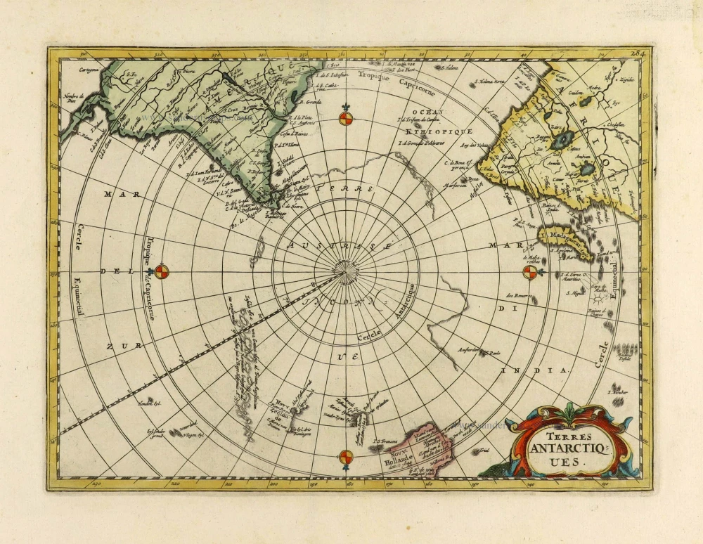
Terres Antarctiques. 1734
South Pole by Henri Du Sauzet.
[Item number: 28364]

Magallanica sive Terra Australis Incognita. [Title in map] 1676
Antarctic Region by Johannes Janssonius van Waesbergen.
[Item number: 28836]
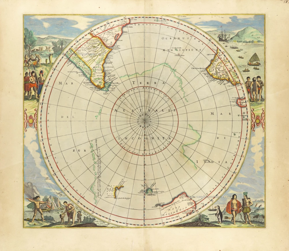
Scarce edition with New Zeeland & Tasmania by J. Janssonius.
Polus Antarcticus. 1666
South Pole, by Henricus Hondius, published by J. Janssonius.
[Item number: 30316]