Kalkar, by Braun & Hogenberg. 1575-1612
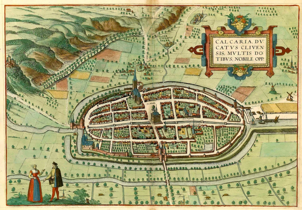
TRANSLATION OF CARTOUCHE TEXT: Kalkar, a town in the Duchy of Cleves, is well known for its many excellent qualities.
COMMENTARY BY BRAUN: "Kalkar was once built on an island in the Rhine by the Count of Cleves, as a defence against Cologne and Guelders, with whom the burghers of Cleves were constantly at war at that time. But now it is a breadbasket for all the surrounding villages and towns, for each week, the outlying farmers bring their corn and grain to market here. Kalkar is in a favourable location because the grain can be brought here on the Rhine in great ships. Kalkar has a good reputation, and its privileges make it one of the most distinguished towns in the Duchy of Cleves."
This bird's-eye view shows the city of Kalkar and its surroundings from the east. The magnificent gate in the middle of the plate is known as the Hanselaer gate. On the left-hand edge of the map can be seen Monterberg castle, one of the most important residences of the Counts of Cleves. In this plate, the town hall stands out clearly and the late Gothic church of St Nicholas, which was consecrated in 1450. On the marketplace stands the so-called court linden tree. North of the marketplace, a caption indicates the Beguinage. Kalkar was granted a municipal charter in 1242, and in the 14th century, it concluded an agreement with Goch and Emmerich regarding cloth production and wool processing. From 1540 to 1572, Kalkar was a Hanseatic city with a population of about 5,000. This prosperity ended in 1598 due to the Dutch Revolt against the Spanish. (Taschen)
Braun G. & Hogenberg F. and the Civitates Orbis Terrarum.
The Civitates Orbis Terrarum, or the "Braun & Hogenberg", is a six-volume town atlas and the most excellent book of town views and plans ever published: 363 engravings, sometimes beautifully coloured. It was one of the best-selling works in the last quarter of the 16th century. Georg Braun wrote the text accompanying the plans and views on the verso. Many plates were engraved after the original drawings of a professional artist, a professional artist, Joris Hoefnagel (1542-1600). The first volume was published in Latin in 1572, and the sixth in 1617. Frans Hogenberg created the tables for volumes I through IV, and Simon van den Neuwel made those for volumes V and VI. Other contributors were cartographers Daniel Freese and Heinrich Rantzau. Works by Jacob van Deventer, Sebastian Münster, and Johannes Stumpf were also used. Translations appeared in German and French.
Following the original publication of Volume 1 of the Civitates in 1572, seven further editions of 1575, 1577, 1582, 1588, 1593, 1599 and 1612 can be identified. Vol.2, first issued in 1575, was followed by further editions in 1597 and 1612. The subsequent volumes appeared in 1581, 1588, 1593, 1599 and 1606. The German translation of the first volume appeared from 1574 on, and the French edition from 1575 on.
Several printers were involved: Theodor Graminaeus, Heinrich von Aich, Gottfried von Kempen, Johannis Sinniger, Bertram Buchholtz and Peter von Brachel, who all worked in Cologne.
Georg Braun (1541-1622)
Georg Braun was born in Cologne in 1541. After his studies in Cologne, he entered the Jesuit Order as a novice. 1561, he obtained his bachelor's degree, and in 1562, he received his Magister Artium. Although he left the Jesuit Order, he studied theology, gaining a licentiate in theology.
Frans Hogenberg (1535-1590)
Frans Hogenberg was a Flemish and German painter, engraver, and mapmaker. He was born in Mechelen as the son of Nicolaas Hogenberg.
By the end of the 1560s, Frans Hogenberg was employed upon Abraham Ortelius's Theatrum Orbis Terrarum, published in 1570; he is named an engraver of numerous maps. In 1568, he was banned from Antwerp by the Duke of Alva and travelled to London, where he stayed a few years before emigrating to Cologne. He immediately embarked on his two most important works, the Civitates, published in 1572 and the Geschichtsblätter, which appeared in several series from 1569 until about 1587.
Thanks to large-scale projects like the Geschichtsblätter and the Civitates, Hogenberg's social circumstances improved with each passing year. He died as a wealthy man in Cologne in 1590.
Calcaria Ducatus Clivensis, Multis Dotibus, Nobile Opp:
Item Number: 21753 Authenticity Guarantee
Category: Antique maps > Europe > Germany - Cities
Old, antique map of Kalkar by Braun & Hogenberg.
Title: Calcaria Ducatus Clivensis, Multis Dotibus, Nobile Opp:
Date: 1575-1612.
Copper engraving, printed on paper.
Size (not including margins): 330 x 475mm (12.99 x 18.7 inches).
Verso: Latin text.
Condition: Original coloured, excellent.
Condition Rating: A+.
From: Civitates Orbis Terrarum, ... Part 2. Köln, 1575-1612.
TRANSLATION OF CARTOUCHE TEXT: Kalkar, a town in the Duchy of Cleves, is well known for its many excellent qualities.
COMMENTARY BY BRAUN: "Kalkar was once built on an island in the Rhine by the Count of Cleves, as a defence against Cologne and Guelders, with whom the burghers of Cleves were constantly at war at that time. But now it is a breadbasket for all the surrounding villages and towns, for each week, the outlying farmers bring their corn and grain to market here. Kalkar is in a favourable location because the grain can be brought here on the Rhine in great ships. Kalkar has a good reputation, and its privileges make it one of the most distinguished towns in the Duchy of Cleves."
This bird's-eye view shows the city of Kalkar and its surroundings from the east. The magnificent gate in the middle of the plate is known as the Hanselaer gate. On the left-hand edge of the map can be seen Monterberg castle, one of the most important residences of the Counts of Cleves. In this plate, the town hall stands out clearly and the late Gothic church of St Nicholas, which was consecrated in 1450. On the marketplace stands the so-called court linden tree. North of the marketplace, a caption indicates the Beguinage. Kalkar was granted a municipal charter in 1242, and in the 14th century, it concluded an agreement with Goch and Emmerich regarding cloth production and wool processing. From 1540 to 1572, Kalkar was a Hanseatic city with a population of about 5,000. This prosperity ended in 1598 due to the Dutch Revolt against the Spanish. (Taschen)
Braun G. & Hogenberg F. and the Civitates Orbis Terrarum.
The Civitates Orbis Terrarum, or the "Braun & Hogenberg", is a six-volume town atlas and the most excellent book of town views and plans ever published: 363 engravings, sometimes beautifully coloured. It was one of the best-selling works in the last quarter of the 16th century. Georg Braun wrote the text accompanying the plans and views on the verso. Many plates were engraved after the original drawings of a professional artist, a professional artist, Joris Hoefnagel (1542-1600). The first volume was published in Latin in 1572, and the sixth in 1617. Frans Hogenberg created the tables for volumes I through IV, and Simon van den Neuwel made those for volumes V and VI. Other contributors were cartographers Daniel Freese and Heinrich Rantzau. Works by Jacob van Deventer, Sebastian Münster, and Johannes Stumpf were also used. Translations appeared in German and French.
Following the original publication of Volume 1 of the Civitates in 1572, seven further editions of 1575, 1577, 1582, 1588, 1593, 1599 and 1612 can be identified. Vol.2, first issued in 1575, was followed by further editions in 1597 and 1612. The subsequent volumes appeared in 1581, 1588, 1593, 1599 and 1606. The German translation of the first volume appeared from 1574 on, and the French edition from 1575 on.
Several printers were involved: Theodor Graminaeus, Heinrich von Aich, Gottfried von Kempen, Johannis Sinniger, Bertram Buchholtz and Peter von Brachel, who all worked in Cologne.
Georg Braun (1541-1622)
Georg Braun was born in Cologne in 1541. After his studies in Cologne, he entered the Jesuit Order as a novice. 1561, he obtained his bachelor's degree, and in 1562, he received his Magister Artium. Although he left the Jesuit Order, he studied theology, gaining a licentiate in theology.
Frans Hogenberg (1535-1590)
Frans Hogenberg was a Flemish and German painter, engraver, and mapmaker. He was born in Mechelen as the son of Nicolaas Hogenberg.
By the end of the 1560s, Frans Hogenberg was employed upon Abraham Ortelius's Theatrum Orbis Terrarum, published in 1570; he is named an engraver of numerous maps. In 1568, he was banned from Antwerp by the Duke of Alva and travelled to London, where he stayed a few years before emigrating to Cologne. He immediately embarked on his two most important works, the Civitates, published in 1572 and the Geschichtsblätter, which appeared in several series from 1569 until about 1587.
Thanks to large-scale projects like the Geschichtsblätter and the Civitates, Hogenberg's social circumstances improved with each passing year. He died as a wealthy man in Cologne in 1590.