
Spain - Escorial, by Braun & Hogenberg. 1618
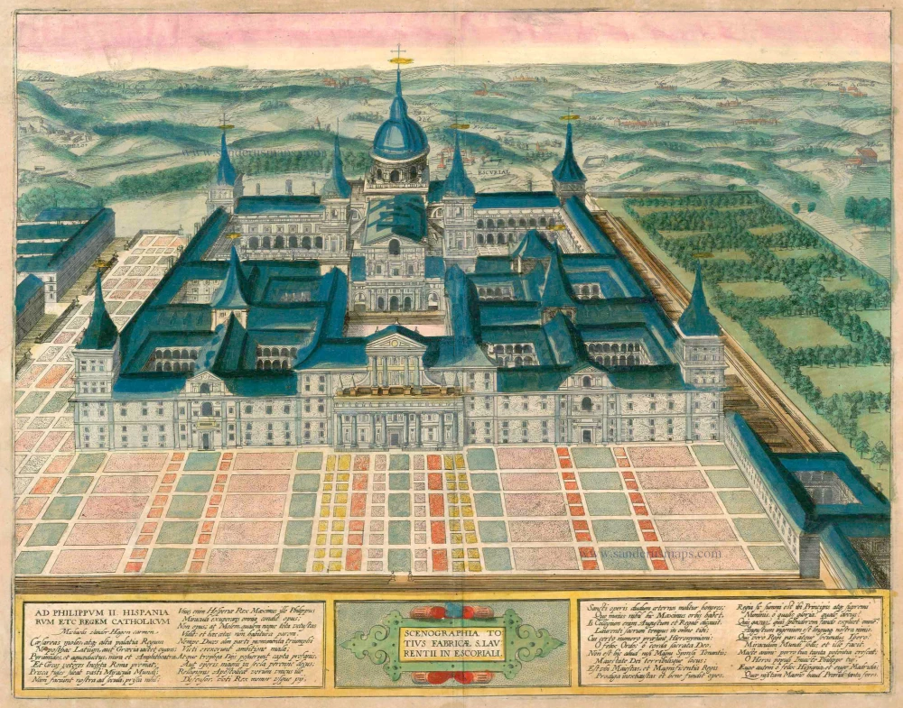


CARTOUCHE CENTRE: Panorama of all built in Escorial in honour of St Lawrence.
CARTOUCHE LEFT AND RIGHT: To Philip II, the Catholic King of Spain, etc. [Ode by Michael van der Hagen, praising Philip II as the "defender of religion".]
COMMENTARY BY BRAUN (on verso): "This building, which is almost unique in the whole world, is a monastery inhabited by Hieronymite monks, as well as a royal palace and a hunting lodge, so delightful and beautiful that it is not inferior to the Seven Wonders of the Ancient World. The monastery's finest gable is on the west side, with three gates or doors, of which the middle one is the finest and gives access to the church, the convent and the chapter."
From a high cavalier perspective, this view from the west of the royal palace of San Lorenzo de El Escorial is a very accurate and detailed representation. Erected in 1563-1584 in the bleak wastes of the Castilian plateau by the Spanish king Philip II, the monastery and palace form a magnificent royal residence. It manifests the desire to combine the royal court with monkish life. The basilica that rises up in the middle forms a link between the spiritual wing on the right, with the cloister and monastery, and the wordly wing on the left, with the palace rooms and the famous art gallery. The king's private apartments lay directly behind the basilica's apse (hidden by the tower). At times a world empire was ruled from the Escorial, and it remained the residence of the kings of Spain up to 1861. (Taschen)
Braun G. & Hogenberg F. and the Civitates Orbis Terrarum.
The Civitates Orbis Terrarum, or the "Braun & Hogenberg", is a six-volume town atlas and the most excellent book of town views and plans ever published: 363 engravings, sometimes beautifully coloured. It was one of the best-selling works in the last quarter of the 16th century. Georg Braun wrote the text accompanying the plans and views on the verso. Many plates were engraved after the original drawings of a professional artist, a professional artist, Joris Hoefnagel (1542-1600). The first volume was published in Latin in 1572, and the sixth in 1617. Frans Hogenberg created the tables for volumes I through IV, and Simon van den Neuwel made those for volumes V and VI. Other contributors were cartographers Daniel Freese and Heinrich Rantzau. Works by Jacob van Deventer, Sebastian Münster, and Johannes Stumpf were also used. Translations appeared in German and French.
Following the original publication of Volume 1 of the Civitates in 1572, seven further editions of 1575, 1577, 1582, 1588, 1593, 1599 and 1612 can be identified. Vol.2, first issued in 1575, was followed by further editions in 1597 and 1612. The subsequent volumes appeared in 1581, 1588, 1593, 1599 and 1606. The German translation of the first volume appeared from 1574 on, and the French edition from 1575 on.
Several printers were involved: Theodor Graminaeus, Heinrich von Aich, Gottfried von Kempen, Johannis Sinniger, Bertram Buchholtz and Peter von Brachel, who all worked in Cologne.
Georg Braun (1541-1622)
Georg Braun was born in Cologne in 1541. After his studies in Cologne, he entered the Jesuit Order as a novice. 1561, he obtained his bachelor's degree, and in 1562, he received his Magister Artium. Although he left the Jesuit Order, he studied theology, gaining a licentiate in theology.
Frans Hogenberg (1535-1590)
Frans Hogenberg was a Flemish and German painter, engraver, and mapmaker. He was born in Mechelen as the son of Nicolaas Hogenberg.
By the end of the 1560s, Frans Hogenberg was employed upon Abraham Ortelius's Theatrum Orbis Terrarum, published in 1570; he is named an engraver of numerous maps. In 1568, he was banned from Antwerp by the Duke of Alva and travelled to London, where he stayed a few years before emigrating to Cologne. He immediately embarked on his two most important works, the Civitates, published in 1572 and the Geschichtsblätter, which appeared in several series from 1569 until about 1587.
Thanks to large-scale projects like the Geschichtsblätter and the Civitates, Hogenberg's social circumstances improved with each passing year. He died as a wealthy man in Cologne in 1590.
Scenographia Totius Fabricae S. Laurentii in Escoriali
Item Number: 23409 Authenticity Guarantee
Category: Antique maps > Europe > Spain and Portugal
Antique map - Bird's-eye view of the Escorial by Braun and Hogenberg.
Engraved by Peter Perret, published in Madrid in 1589 after revision drawings by Juan de Herrera.
Copper engraving
Size: 36.5 x 47cm (14.2 x 18.3 inches)
Verso text: Latin
Condition: Excellent, nice old colour.
Condition Rating: A
References: Van der Krogt 4, 1259, State 1; Taschen, Braun and Hogenberg, p. 438.
From: Theatri praecipuarum Totius Mundi Urbium Liber Sextus Anno MDCXVIII. (Van der Krogt 4, 41:1.6)
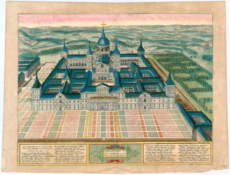
CARTOUCHE CENTRE: Panorama of all built in Escorial in honour of St Lawrence.
CARTOUCHE LEFT AND RIGHT: To Philip II, the Catholic King of Spain, etc. [Ode by Michael van der Hagen, praising Philip II as the "defender of religion".]
COMMENTARY BY BRAUN (on verso): "This building, which is almost unique in the whole world, is a monastery inhabited by Hieronymite monks, as well as a royal palace and a hunting lodge, so delightful and beautiful that it is not inferior to the Seven Wonders of the Ancient World. The monastery's finest gable is on the west side, with three gates or doors, of which the middle one is the finest and gives access to the church, the convent and the chapter."
From a high cavalier perspective, this view from the west of the royal palace of San Lorenzo de El Escorial is a very accurate and detailed representation. Erected in 1563-1584 in the bleak wastes of the Castilian plateau by the Spanish king Philip II, the monastery and palace form a magnificent royal residence. It manifests the desire to combine the royal court with monkish life. The basilica that rises up in the middle forms a link between the spiritual wing on the right, with the cloister and monastery, and the wordly wing on the left, with the palace rooms and the famous art gallery. The king's private apartments lay directly behind the basilica's apse (hidden by the tower). At times a world empire was ruled from the Escorial, and it remained the residence of the kings of Spain up to 1861. (Taschen)
Braun G. & Hogenberg F. and the Civitates Orbis Terrarum.
The Civitates Orbis Terrarum, or the "Braun & Hogenberg", is a six-volume town atlas and the most excellent book of town views and plans ever published: 363 engravings, sometimes beautifully coloured. It was one of the best-selling works in the last quarter of the 16th century. Georg Braun wrote the text accompanying the plans and views on the verso. Many plates were engraved after the original drawings of a professional artist, a professional artist, Joris Hoefnagel (1542-1600). The first volume was published in Latin in 1572, and the sixth in 1617. Frans Hogenberg created the tables for volumes I through IV, and Simon van den Neuwel made those for volumes V and VI. Other contributors were cartographers Daniel Freese and Heinrich Rantzau. Works by Jacob van Deventer, Sebastian Münster, and Johannes Stumpf were also used. Translations appeared in German and French.
Following the original publication of Volume 1 of the Civitates in 1572, seven further editions of 1575, 1577, 1582, 1588, 1593, 1599 and 1612 can be identified. Vol.2, first issued in 1575, was followed by further editions in 1597 and 1612. The subsequent volumes appeared in 1581, 1588, 1593, 1599 and 1606. The German translation of the first volume appeared from 1574 on, and the French edition from 1575 on.
Several printers were involved: Theodor Graminaeus, Heinrich von Aich, Gottfried von Kempen, Johannis Sinniger, Bertram Buchholtz and Peter von Brachel, who all worked in Cologne.
Georg Braun (1541-1622)
Georg Braun was born in Cologne in 1541. After his studies in Cologne, he entered the Jesuit Order as a novice. 1561, he obtained his bachelor's degree, and in 1562, he received his Magister Artium. Although he left the Jesuit Order, he studied theology, gaining a licentiate in theology.
Frans Hogenberg (1535-1590)
Frans Hogenberg was a Flemish and German painter, engraver, and mapmaker. He was born in Mechelen as the son of Nicolaas Hogenberg.
By the end of the 1560s, Frans Hogenberg was employed upon Abraham Ortelius's Theatrum Orbis Terrarum, published in 1570; he is named an engraver of numerous maps. In 1568, he was banned from Antwerp by the Duke of Alva and travelled to London, where he stayed a few years before emigrating to Cologne. He immediately embarked on his two most important works, the Civitates, published in 1572 and the Geschichtsblätter, which appeared in several series from 1569 until about 1587.
Thanks to large-scale projects like the Geschichtsblätter and the Civitates, Hogenberg's social circumstances improved with each passing year. He died as a wealthy man in Cologne in 1590.