
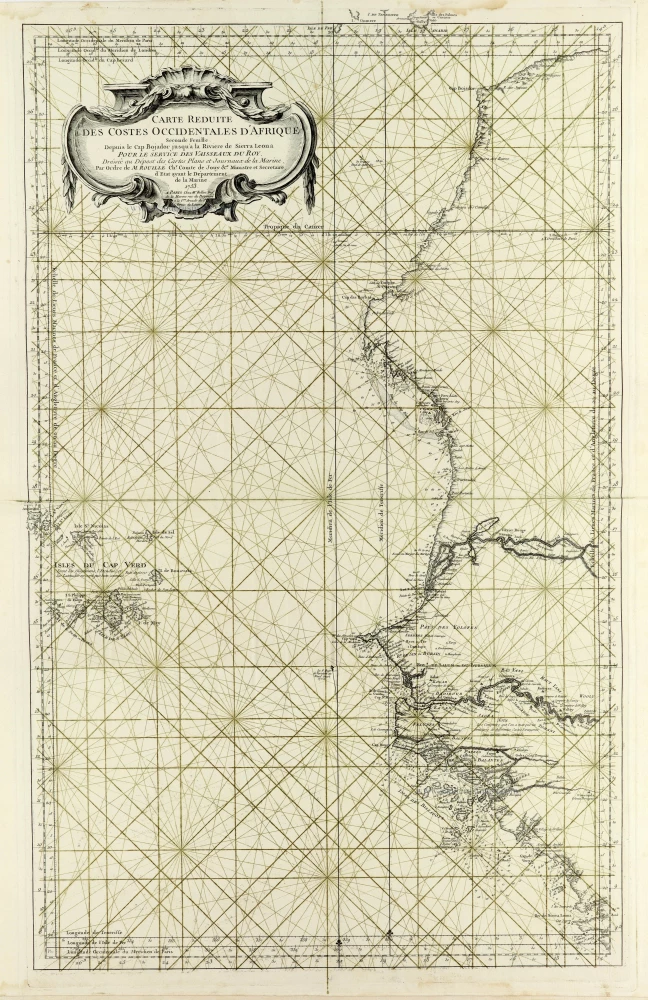
Western Africa and the Cape Verde Islands, by J.N. Bellin. 1756-1770
Jacques-Nicolas Bellin (1703-1772)
Jacques-Nicolas Bellin, a French geographer, was among the most important mapmakers of the eighteenth century. In 1721, at the age of 18, he was appointed hydrographer of the Ministry of the Navy following the French hydrographic office's creation and the Dépot of charts and plans of the Navy. Appointed hydrographic engineer in August 1741. Member of the Academy of the Navy and the Royal Society of London.
Over the course of a 50-year career, he drew the maps of several major works of his time such as Histoire et description générale de la Nouvelle-France de Charlevoix (1744); Histoire générale des voyages de l'Abbé Prévost (published between 1746 and 1759) ); Neptune François (1753), Hydrographie Françoise (1756-1765), and Petit Atlas Français (1763) - reissued as Petit Atlas Maritime (1765). He is the most copied cartographer of the 18th century.
His maps of Canada and the French territories of North America are of considerable value. This is all the more remarkable since, an archetype of the cabinet cartographer, Bellin never came to America. For his cartography of the St. Lawrence River, he entrusted handwritten maps to navigators to correct and enrich. With each return of these maps, he was updating his knowledge. Two basic needs drive its cartography of North America: to secure navigation on the St. Lawrence River and to claim for France the lands explored by the French in the Great Lakes region and along the Mississippi River.
Jacques-Nicolas Bellin died on March 21, 1772, in Versailles. In the burial certificate, he is described as "the first engineer of the navy and the deposit of plans, royal censor of the academy of navy and the royal society of London".
Carte Réduite des Costes Occidentales d'Afrique Depuis le Cap Bojador jusqu'a la Rivière de Sierra Leona.
Item Number: 33186 Authenticity Guarantee
Category: Antique maps > Africa
Sea chart of Western Africa and the Cape Verde Islands, by J.N. Bellin.
Title: Carte Réduite des Costes Occidentales d'Afrique Depuis le Cap Bojador jusqu'a la Rivière de Sierra Leona.
Seconde Feuille
Pour le Service des Vaisseaux du Roy.
Dressée au Dépost des Cartes Plans et Journaux de la Marine.
Par Ordre de M. Rouillé Chr Comte de Jouy &a. Ministre et Secretaire d'Etat ayant le Départemt de la Marine. 1753
a Paris Chez Mr Bellin Ingr. de la Marine rue du Doyenné à la Iere Arcade de St Louis du Louvre.
Date: 1756-1770.
Date on map: 1753.
Copper engraving, printed on paper.
Image size: 890 x 555mm (35 x 21¾ inches).
Sheet size: 920 x 635mm (36¼ x 25 inches).
Verso: Blank.
Condition: With rhumblines drawn by hand, excellent.
Condition Rating: A+.
From: L'Hydrographie Françoise ou Recueil des Cartes Dressées au Deposit des Plans de la Marine pour le Service des Vaisseaux du Roy. Paris, 1756-70. (Shirley (Brit.Lib.), M.Bell-2a)
Jacques-Nicolas Bellin (1703-1772)
Jacques-Nicolas Bellin, a French geographer, was among the most important mapmakers of the eighteenth century. In 1721, at the age of 18, he was appointed hydrographer of the Ministry of the Navy following the French hydrographic office's creation and the Dépot of charts and plans of the Navy. Appointed hydrographic engineer in August 1741. Member of the Academy of the Navy and the Royal Society of London.
Over the course of a 50-year career, he drew the maps of several major works of his time such as Histoire et description générale de la Nouvelle-France de Charlevoix (1744); Histoire générale des voyages de l'Abbé Prévost (published between 1746 and 1759) ); Neptune François (1753), Hydrographie Françoise (1756-1765), and Petit Atlas Français (1763) - reissued as Petit Atlas Maritime (1765). He is the most copied cartographer of the 18th century.
His maps of Canada and the French territories of North America are of considerable value. This is all the more remarkable since, an archetype of the cabinet cartographer, Bellin never came to America. For his cartography of the St. Lawrence River, he entrusted handwritten maps to navigators to correct and enrich. With each return of these maps, he was updating his knowledge. Two basic needs drive its cartography of North America: to secure navigation on the St. Lawrence River and to claim for France the lands explored by the French in the Great Lakes region and along the Mississippi River.
Jacques-Nicolas Bellin died on March 21, 1772, in Versailles. In the burial certificate, he is described as "the first engineer of the navy and the deposit of plans, royal censor of the academy of navy and the royal society of London".
