
Algiers, by Georg Braun and Frans Hogenberg. 1575-1612

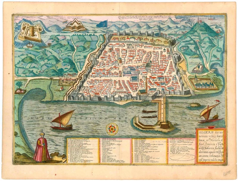
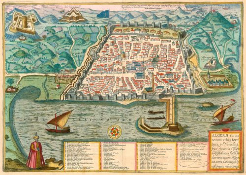
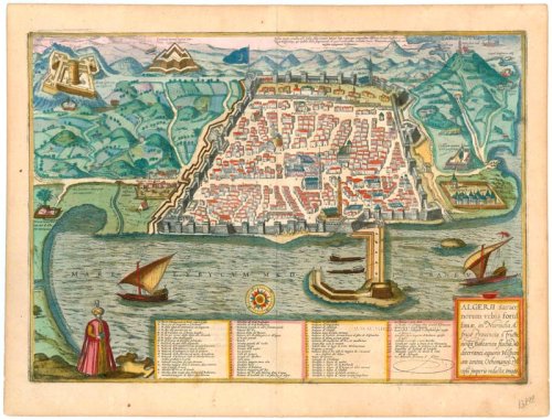

TRANSLATION OF CARTOUCHE TEXT: View of Algiers, the most powerful town of the Saracens, built in the Numidian province of Africa. Situated on the edge of the Balearic Current in the Mediterranean Sea, across from Spain. Under Ottoman rule.
COMMENTARY BY BRAUN (on verso): "The inhabitants of Algiers go on raids, cruising the ocean with scores of galleys, and have laid waste to the islands of Majorca, Minorca and Formentera on numerous occasions. Hence, King Ferdinand has commenced an immense naval attack against the town and has constructed a castle across from it, on top of a high peak, as far away as a rifle can shoot, although it couldn't do any damage to the city walls."
The plate of Algiers depicts the formidably fortified town in a low bird's-eye view, with a figure bottom left dressed in a turban and kaftan, the colouring of which matches that of the surrounding countryside. The fortress-like layout of the town, conveniently located on a harbour, features a well-laid out Old Town with five mosques, including, in the foreground, the Great Mosque (Q) from the 11th century. While Algiers belonged to the Kingdom of Aragon after the Reconquista in 1492, in the early 16th century, many Moors, Moriscos and Corsairs made Algiers and Tunis their base. Among others, Ferdinand, the Catholic, campaigned against their piracy. On the other hand, the Turks supported the North Africans, and, except for Morocco, the land became part of the Ottoman Empire between 1518 and 1519. Algiers is today the capital of Algeria, where approximately 2.2 million people reside. (Taschen)
Braun G. & Hogenberg F. and the Civitates Orbis Terrarum.
The Civitates Orbis Terrarum, also known as the 'Braun & Hogenberg', is a six-volume town atlas and the most excellent book of town views and plans ever published: 363 engravings, sometimes beautifully coloured. It was one of the best-selling works in the last quarter of the 16th century. Georg Braun, a skilled writer, wrote the text accompanying the plans and views on the verso. Many plates were engraved after the original drawings of a professional artist, Joris Hoefnagel (1542-1600). The first volume was published in Latin in 1572 and the sixth in 1617. Frans Hogenberg, a talented engraver, created the tables for volumes I through IV, and Simon van den Neuwel made those for volumes V and VI. Other contributors were cartographers Daniel Freese and Heinrich Rantzau, who provided valuable geographical information. Works by Jacob van Deventer, Sebastian Münster, and Johannes Stumpf were also used as references. Translations appeared in German and French, making the atlas accessible to a broader audience.
Since its original publication of volume 1 in 1572, the Civitates Orbis Terrarum has left an indelible mark on the history of cartography. Seven more editions followed the first volume in 1575, 1577, 1582, 1588, 1593, 1599, and 1612. Vol.2, initially released in 1575, saw subsequent editions in 1597 and 1612. The subsequent volumes, each a treasure trove of historical insights, graced the world in 1581, 1588, 1593, 1599, and 1606. The German translation of the first volume, a testament to its widespread appeal, debuted in 1574, followed by the French edition in 1575.
Several printers were involved: Theodor Graminaeus, Heinrich von Aich, Gottfried von Kempen, Johannis Sinniger, Bertram Buchholtz, and Peter von Brachel, all of whom worked in Cologne.
Georg Braun (1541-1622)
Georg Braun, the author of the text accompanying the plans and views in the Civitates Orbis Terrarum, was born in Cologne in 1541. After his studies in Cologne, he entered the Jesuit Order as a novice, indicating his commitment to learning and intellectual pursuits. In 1561, he obtained his bachelor's degree; in 1562, he received his Magister Artium, further demonstrating his academic achievements. Although he left the Jesuit Order, he continued his studies in theology, gaining a licentiate in theology. His theological background likely influenced the content and tone of the text in the Civitates Orbis Terrarum, adding a unique perspective to the work.
Frans Hogenberg (1535-1590)
Frans Hogenberg was a Flemish and German painter, engraver, and mapmaker. He was born in Mechelen as the son of Nicolaas Hogenberg.
By the end of the 1560s, Frans Hogenberg was employed upon Abraham Ortelius's Theatrum Orbis Terrarum, published in 1570; he is named an engraver of numerous maps. In 1568, he was banned from Antwerp by the Duke of Alva and travelled to London, where he stayed a few years before emigrating to Cologne. He immediately embarked on his two most important works, the Civitates, published in 1572 and the Geschichtsblätter, which appeared in several series from 1569 until about 1587.
Thanks to large-scale projects like the Geschichtsblätter and the Civitates, Hogenberg's social circumstances improved with each passing year. He died as a wealthy man in Cologne in 1590.
Algerii Saracenorum Urbis Fortissimae ...
Item Number: 23292 Authenticity Guarantee
Category: Antique maps > Africa
Algiers, by Georg Braun and Frans Hogenberg.
Title: Algerii Saracenorum Urbis Fortissimae ...
Date of the first edition: 1575.
Date of this map: 1575-1612.
Copper engraving, printed on paper.
Size (not including margins): 350 x 490mm (13¾ x 19¼ inches).
Verso: Latin text.
Condition: Superb old colour, excellent.
Condition Rating: A+.
From: Civitates Orbis Terrarum, ... Part 2. Köln, 1575-1612.
TRANSLATION OF CARTOUCHE TEXT: View of Algiers, the most powerful town of the Saracens, built in the Numidian province of Africa. Situated on the edge of the Balearic Current in the Mediterranean Sea, across from Spain. Under Ottoman rule.
COMMENTARY BY BRAUN (on verso): "The inhabitants of Algiers go on raids, cruising the ocean with scores of galleys, and have laid waste to the islands of Majorca, Minorca and Formentera on numerous occasions. Hence, King Ferdinand has commenced an immense naval attack against the town and has constructed a castle across from it, on top of a high peak, as far away as a rifle can shoot, although it couldn't do any damage to the city walls."
The plate of Algiers depicts the formidably fortified town in a low bird's-eye view, with a figure bottom left dressed in a turban and kaftan, the colouring of which matches that of the surrounding countryside. The fortress-like layout of the town, conveniently located on a harbour, features a well-laid out Old Town with five mosques, including, in the foreground, the Great Mosque (Q) from the 11th century. While Algiers belonged to the Kingdom of Aragon after the Reconquista in 1492, in the early 16th century, many Moors, Moriscos and Corsairs made Algiers and Tunis their base. Among others, Ferdinand, the Catholic, campaigned against their piracy. On the other hand, the Turks supported the North Africans, and, except for Morocco, the land became part of the Ottoman Empire between 1518 and 1519. Algiers is today the capital of Algeria, where approximately 2.2 million people reside. (Taschen)
Braun G. & Hogenberg F. and the Civitates Orbis Terrarum.
The Civitates Orbis Terrarum, also known as the 'Braun & Hogenberg', is a six-volume town atlas and the most excellent book of town views and plans ever published: 363 engravings, sometimes beautifully coloured. It was one of the best-selling works in the last quarter of the 16th century. Georg Braun, a skilled writer, wrote the text accompanying the plans and views on the verso. Many plates were engraved after the original drawings of a professional artist, Joris Hoefnagel (1542-1600). The first volume was published in Latin in 1572 and the sixth in 1617. Frans Hogenberg, a talented engraver, created the tables for volumes I through IV, and Simon van den Neuwel made those for volumes V and VI. Other contributors were cartographers Daniel Freese and Heinrich Rantzau, who provided valuable geographical information. Works by Jacob van Deventer, Sebastian Münster, and Johannes Stumpf were also used as references. Translations appeared in German and French, making the atlas accessible to a broader audience.
Since its original publication of volume 1 in 1572, the Civitates Orbis Terrarum has left an indelible mark on the history of cartography. Seven more editions followed the first volume in 1575, 1577, 1582, 1588, 1593, 1599, and 1612. Vol.2, initially released in 1575, saw subsequent editions in 1597 and 1612. The subsequent volumes, each a treasure trove of historical insights, graced the world in 1581, 1588, 1593, 1599, and 1606. The German translation of the first volume, a testament to its widespread appeal, debuted in 1574, followed by the French edition in 1575.
Several printers were involved: Theodor Graminaeus, Heinrich von Aich, Gottfried von Kempen, Johannis Sinniger, Bertram Buchholtz, and Peter von Brachel, all of whom worked in Cologne.
Georg Braun (1541-1622)
Georg Braun, the author of the text accompanying the plans and views in the Civitates Orbis Terrarum, was born in Cologne in 1541. After his studies in Cologne, he entered the Jesuit Order as a novice, indicating his commitment to learning and intellectual pursuits. In 1561, he obtained his bachelor's degree; in 1562, he received his Magister Artium, further demonstrating his academic achievements. Although he left the Jesuit Order, he continued his studies in theology, gaining a licentiate in theology. His theological background likely influenced the content and tone of the text in the Civitates Orbis Terrarum, adding a unique perspective to the work.
Frans Hogenberg (1535-1590)
Frans Hogenberg was a Flemish and German painter, engraver, and mapmaker. He was born in Mechelen as the son of Nicolaas Hogenberg.
By the end of the 1560s, Frans Hogenberg was employed upon Abraham Ortelius's Theatrum Orbis Terrarum, published in 1570; he is named an engraver of numerous maps. In 1568, he was banned from Antwerp by the Duke of Alva and travelled to London, where he stayed a few years before emigrating to Cologne. He immediately embarked on his two most important works, the Civitates, published in 1572 and the Geschichtsblätter, which appeared in several series from 1569 until about 1587.
Thanks to large-scale projects like the Geschichtsblätter and the Civitates, Hogenberg's social circumstances improved with each passing year. He died as a wealthy man in Cologne in 1590.
Related items

Alexandria, Vetustissimum Aegypti Emporium, Amplissima Civitas .Penon de Veles. 1597
Egypt - Alexandria by Georg Braun & Frans Hogenberg
[Item number: 24010]

Anfa, quibusdam Anaffa [on sheet with] Azaamurum [and] Diu [and] Goa. 1582
Casablanca (Anfa) - Azemmour (Azamor) - Diu - Old Goa (Velha Goa), by Braun & Hogenberg.
[Item number: 25333]

Algiers c. 1690
Algiers (Algeria) by J. Peeters.
[Item number: 31365]