Old, antique map of Central and Northeast Africa by A. Ortelius 1601


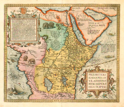

Presbiteri Iohannis, sive, abissinorum Imperii Descriptio.
Item Number: 9293 Authenticity Guarantee
Category: Antique maps > Africa
Antique map of Central and Northeast Africa, the country of Prester John, by A. Ortelius
Date of the first edition: 1573
Date of this map: 1601
Copper engraving
Size: 37.5 x 44cm (14.5 x 17.1 inches)
Verso text: Latin
Condition: Contemporary old coloured, excellent.
Condition Rating: A
References: Van der Krogt 3, 8720:31; Van den Broecke, 175; Norwich O.I., 11.
From: Theatrum Orbis Terrarum Abrahami Ortelii Antverp. Geographi Regii. Antwerpen, Plantin Press, 1601. (Van der Krogt 3, 1:052)
Based on Gastaldi's wall map of Africa (1564).
TRANSLATION OF CARTOUCHE TEXT: "Presbyterius Ioannes, specially chosen by God, pillar of faith, born from the tribe of Judah, son of David, son of Salomon, son of the pillar of Zion, son from the seed of Jacob, son of the hand of Maria, son of Nahum's flesh, son of the holy Peter and Paul in mercy, emperor of upper and great AEthiopia, and of the legal grounds and countries of the most elevated kingdoms; king of Goa, Caffates, Fatigar, Angota, Baru, Balinguanza, Adea, Vangua, Goiama where the Nile has its sources, of Amara, Banguamedrum, Ambea, Vangucum, Tigremahon, of Saba, homeland of the Queen of Saba, of Barnagassum and Lord of all of Namibia, extending all the way to Egypt."
Priest John is a mythical king with a long cartographical history, who was supposed to provide a stronghold against the Barbarians, and to be an ally for crusaders. His kingdom was originally surmised to have been located in India (for instance by Waldseemüller in 1507), but was later placed in Africa (Gemma Frisius-Ptolemy 1522). (Van den Broecke)