
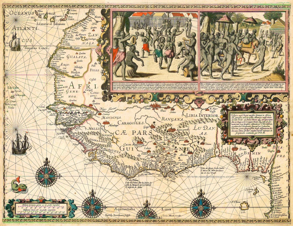
Old, antique map of West Africa - Guinea by Allard C. 1695
The Allard Family
The founder of this family of map-makers, publishers and print-sellers was Huych (Hugo) Allard (1625-1691). He worked in Amsterdam in 1684 and is supposed to have begun his business as early as 1645. He died in 1691, leaving his shop to his son, Carel Allard (1648-c. 1706). Carel brought out many maps and some atlases. His atlases are mainly composed of maps from the stock of other publishers like Janssonius and De Wit. However, some maps were his original creations. The States of Holland granted him a privilege for these maps in 1683.
One of the sons of Carel, Abraham Allard (1676-c.1730), joined his father in the map trade and was accepted as a member of the ‘Constvercoopers gilde’ (Art dealer’s Guild) in 1708.
The original geographical maps by Allard, designed and cut between 1680 and 1700, are very decorative, well-composed and up-to-date.
Effigies Ampli Regni Auriferi Guineae in Africa ...
Item Number: 20797 Authenticity Guarantee
Category: Antique maps > Africa
Very rare map of West Africa and Guinea by Luis Teixeira, engraved by Baptista van Doeticum and published by Carolus Allard.
Copper engraving
Size: 46 x 60cm (18 x 24 inches)
Verso: Blank
Condition: Old coloured, slightly age-toned and a few stains, nice copy.
References: TNH Doet4, 1041; Schilder 7, pp. 297-301, 12.5 third state - no copy known of the first state..
From: Separate publication
"The map's title appears in a large scrollwork cartouche in the interior of Benin. Its Latin text indicates the limits of the region depicted and the sources on which the map is based, and refers to Pieter de Maree's report: 'Depiction of the expansive and gold-rich kingdom of Guinea in Africa, which stretches from the Atlantic islands popurarly called the Cape Verde Islands to the river in Benin (on which the great and royal city of Benin lies), and from there to the foothills of Lopez Gonsalvez, drawn by S. Rovelasco and executed in fine line by Ludovicus Texera (Luis Texeira), chief cosmographer to the King of Spain. A book with an extensive depiction of these regions was published in the same year by P.D.M. (= Pieter de Marees)'.
The upper right portion of the map is dominated by two scenes of native people. The one of the left shows people dancing. The right-hand scene shows how the nobility of the Benin court normally travel.
The entire artistic composition and execution make this map one of the most beautiful products of the Dutch engraver's art from the years around 1600.
Luis Texeira's map of West Africa influenced other seventeenth-century maps, particularly the map of Guinea included in Hondius's 1606 Amsterdam edition of Mercator's atlas, where the depiction of the coast and the rivers closely agrees with Teiceira's." (Schilder)
The Allard Family
The founder of this family of map-makers, publishers and print-sellers was Huych (Hugo) Allard (1625-1691). He worked in Amsterdam in 1684 and is supposed to have begun his business as early as 1645. He died in 1691, leaving his shop to his son, Carel Allard (1648-c. 1706). Carel brought out many maps and some atlases. His atlases are mainly composed of maps from the stock of other publishers like Janssonius and De Wit. However, some maps were his original creations. The States of Holland granted him a privilege for these maps in 1683.
One of the sons of Carel, Abraham Allard (1676-c.1730), joined his father in the map trade and was accepted as a member of the ‘Constvercoopers gilde’ (Art dealer’s Guild) in 1708.
The original geographical maps by Allard, designed and cut between 1680 and 1700, are very decorative, well-composed and up-to-date.