
Secret Atlas Chart - very rare
Mauritius, by J. Van Keulen II. 1753


The House of Van Keulen
For more than two centuries, the chart makers firm of Van Keulen was established in the house with the name of “De Gekroonde Lootsman” (The Crowned Pilot). In 1678, the founder of the firm, Johannes I Van Keulen (1634-1689), registered with the Amsterdam booksellers’ guild. He had enlisted the aid of the well-known Mathematical Practitioner Claas Janz Vooght in the preparation of his nautical publications. In 1680 he published the first edition of the Zee-Atlas with 40 charts, all issued for the first time. In the short period of four years, they produced the five volumes of the Nieuwe Groote Ligtende Zee-Fakkel (1681-85). His acquisition of the stock of the bookseller Hendrik Doncker was an essential factor in the development of the firm.
In 1678 a son, Gerard Van Keulen (1678-1726), was born out of Johannes’s first marriage. This son was endowed with talent. He was a skilful engraver and proficient in mathematics and navigational science. Gerard was responsible for establishing the scientific basis of the firm of Van Keulen. In 1714 he was appointed to the office of hydrographer to the Dutch East India Company. The Van Keulens remained chart makers to the East India Company until the Company’s liquidation.
With the introductions to the Zee-Fakkel and Zee-Atlas, Gerard van Keulen gave a new impetus to the firm. Unfortunately, he did not live long, dying when he was 49. The business was carried on by his widow Ludwina Konst. Shortly before Gerard’s death, his son Johannes II had entered the bookseller’s guild, and in 1726 he assumed the management of the firm, though his mother retained her financial interests in the business.
Johannes II Van Keulen (1704-1755) is known in particular for his publication in 1753 of a sixth volume of the Zee-Fakkel, the volume containing the charts of the route to the East Indies.
Johannes II had two sons; they joined the firm as partners in 1757. A considerable number of books appeared in the period 1778-1801. New issues of the Zee-Fakkel again saw the light. The firm flourished under different names until 1885.
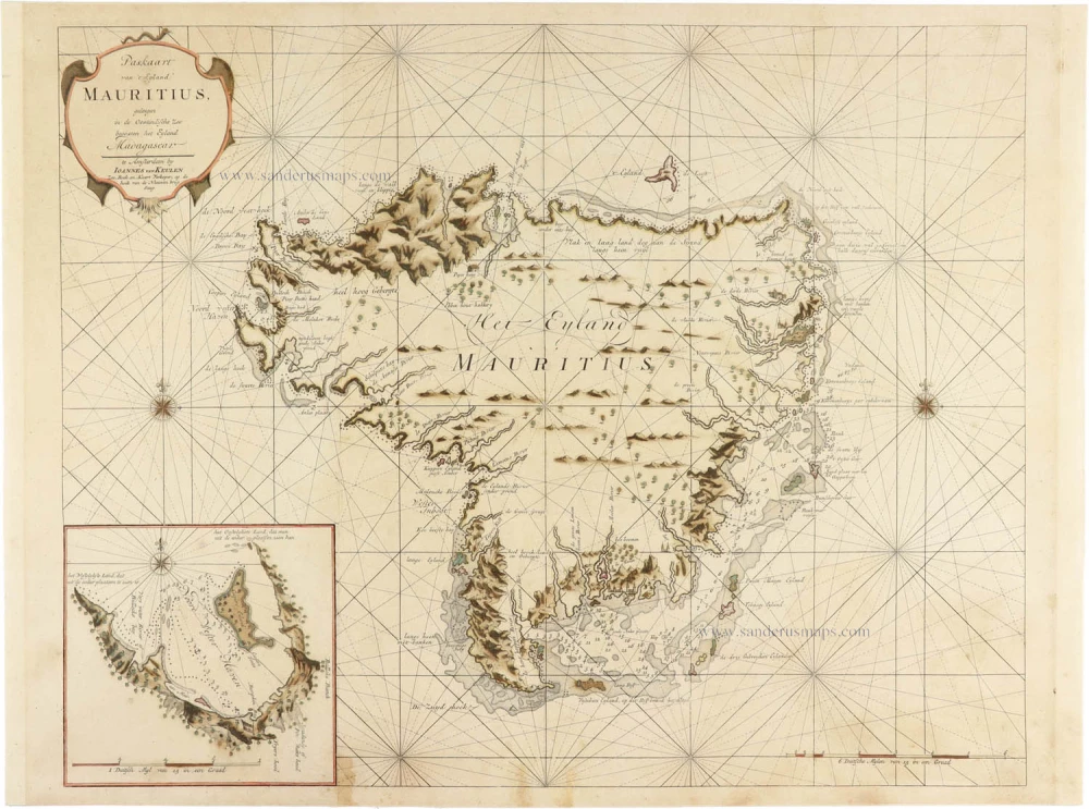
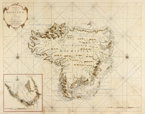
Paskaart van 't Eyland MAURITIUS, geleegen in de Oostindische Zee beoosten het Eyland Madagascar.
Item Number: 30986 Authenticity Guarantee
Category: Antique maps > Africa
Sea chart of Mauritius, by J. Van Keulen II.
Title: Paskaart van 't Eyland MAURITIUS, geleegen in de Oostindische Zee beoosten het Eyland Madagascar
te Amsterdam by IOANNES VAN KEULEN Zee-Boek en Kaart Verkoper, op de hoek van de Nieuwen brug Steeg.
Inset map of the northwest harbour.
Highly detailed map of Mauritius from Part VI of the Zee-Fakkel. The atlas contained charts for navigation covering the waters from Cape Good Hope to Nagasaki and was intended only for VOC use.
Date of the first edition: 1753.
Date of this map: 1753.
Copper engraving, printed on paper.
Image size: 410 x 525mm (16.14 x 20.67 inches).
Sheet size: 435 x 585mm (17.13 x 23.03 inches).
Verso: Blank.
Condition: Original coloured, backed with paper.
Condition Rating: A.
From: De Nieuwe Groote Lichtende Zee-Fakkel, Het Sesde Deel, Vertoonende de Zee-Kusten, Eylanden en Havens van Oost-Indien. t'Amsterdam by Joannes van Keulen, Boek-en Kaart-verkoper aan de Nieuwe Brug in de gekroonde Lootsman, 1753.
The House of Van Keulen
For more than two centuries, the chart makers firm of Van Keulen was established in the house with the name of “De Gekroonde Lootsman” (The Crowned Pilot). In 1678, the founder of the firm, Johannes I Van Keulen (1634-1689), registered with the Amsterdam booksellers’ guild. He had enlisted the aid of the well-known Mathematical Practitioner Claas Janz Vooght in the preparation of his nautical publications. In 1680 he published the first edition of the Zee-Atlas with 40 charts, all issued for the first time. In the short period of four years, they produced the five volumes of the Nieuwe Groote Ligtende Zee-Fakkel (1681-85). His acquisition of the stock of the bookseller Hendrik Doncker was an essential factor in the development of the firm.
In 1678 a son, Gerard Van Keulen (1678-1726), was born out of Johannes’s first marriage. This son was endowed with talent. He was a skilful engraver and proficient in mathematics and navigational science. Gerard was responsible for establishing the scientific basis of the firm of Van Keulen. In 1714 he was appointed to the office of hydrographer to the Dutch East India Company. The Van Keulens remained chart makers to the East India Company until the Company’s liquidation.
With the introductions to the Zee-Fakkel and Zee-Atlas, Gerard van Keulen gave a new impetus to the firm. Unfortunately, he did not live long, dying when he was 49. The business was carried on by his widow Ludwina Konst. Shortly before Gerard’s death, his son Johannes II had entered the bookseller’s guild, and in 1726 he assumed the management of the firm, though his mother retained her financial interests in the business.
Johannes II Van Keulen (1704-1755) is known in particular for his publication in 1753 of a sixth volume of the Zee-Fakkel, the volume containing the charts of the route to the East Indies.
Johannes II had two sons; they joined the firm as partners in 1757. A considerable number of books appeared in the period 1778-1801. New issues of the Zee-Fakkel again saw the light. The firm flourished under different names until 1885.
Related items

Isola di Madagascar, ò di S. Lorenzo. 1696
Madagascar, Réunion, and southwest Africa by Vincenzo Coronelli.
[Item number: 28680]

Carte Générale des Isles, dont les figures ci-dessus offrent un plus ample détail. - Cartes Paticulières des Isles de France, de Bourbon et de Rodrigue 1780
Mauritius, Réunion, and Rodrigues, by Rigobert Bonne.
[Item number: 33136]
new