
Old antique map of America by J. Janssonius. 1632+

In 1623 J. Janssonius produced a set of continental maps derived from those of his brother-in-law Jodocus Hondius in 1618-19. Of these, Africa and Asia bear the date 1623, and a legend at the top of the America one states: 'Huc usque processerunt Amstelodamenses. A°.1622'. This very rare map is most easily distinguished by the chipped top right hand corner of the plate that appears in virtually all known examples.The figures bordering the sides have been reversed, and curiously the lower corner town plans have been transposed. The cartouche also bears the addition of two skulls. Geographically the map is identical to that of Hondius, with the notable exception of a new and more correct depiction of Tierra del Fuego, and the islands discovered by le Maire and Schouten in the Pacific.
In 1630 both Blaeu and Janssonius published an Appendix to the work of Mercator. This marked the beginning of a great period of competitive Dutch atlas production. Only four known examples of Janssonius' atlas survive; they contain this map in its second state. It was included again inthe 1631 edition, which is known by only one example. Koeman states that the continental maps were not used again. However, he goes on to list them in later Dutch and French editions where the lower border of views has been removed. This made it easier fit into the atlas. The Asian map bears the date 1632, indicating the probable year of alteration. (Burden)
The Janssonius Family
Joannes Janssonius (Arnhem, 1588-1664), son of the Arnhem publisher Jan Janssen, married Elisabeth Hondius, daughter of Jodocus Hondius, in Amsterdam in 1612. After his marriage, he settled down in this town as a bookseller and publisher of cartographic material. In 1618, he established himself in Amsterdam next door to Blaeu’s bookshop. He entered into serious competition with Willem Jansz. Blaeu when copying Blaeu’s Licht der Zeevaert after the expiration of the privilege in 1620. His activities concerned the publication of atlases, books, single maps, and an extensive book trade with branches in Frankfurt, Danzig, Stockholm, Copenhagen, Berlin, Koningsbergen, Geneva, and Lyon. In 1631, he began publishing atlases together with Henricus Hondius.
In the early 1640s, Henricus Hondius left the atlas publishing business to Janssonius. Competition with Joan Blaeu, Willem’s son and successor, in atlas production, prompted Janssonius to enlarge his Atlas Novus finally into a work of six volumes, into which a sea atlas and an atlas of the Old World were inserted. Other atlases published by Janssonius are Mercator’s Atlas Minor, Hornius’s historical atlas (1652), the townbooks in eight volumes (1657), Cellarius’s Atlas Coelestis and several sea atlases and pilot guides.
After the death of Joannes Janssonius, the shop and publishing firm were continued by the heirs under the direction of Johannes van Waesbergen (c. 1616-1681), son-in-law of Joannes Janssonius. Van Waesbergen added Janssonius's name to his own.
In 1676, Joannes Janssonius’s heirs sold by auction “all the remaining Atlases in Latin, French, High and Low German, as well as the Stedeboecken in Latin, in 8 volumes, bound and unbound, maps, plates belonging to the Atlas and Stedeboecken.” The copperplates from Janssonius’s atlases were afterwards sold to Schenk and Valck.
America Noviter Delineata. Auct. Judoco Hondio.
Item Number: 25785 Authenticity Guarantee
Category: Antique maps > America > The Americas
Old, antique map of America by J. Janssonius.
Cartographer: J. Hondius
Date of the first edition: 1623 (= State 1, only 1 known example).
Date of this map: c. 1632 (See Schilder 6, 18/4)
Copper engraving, printed on paper.
Size (not including margins): 41 x 55.5cm (16 x 21.6 inches)
Verso: Blank
Condition: New right margin with small reinstatement of lower right corner, some small repairs in margins.
Condition Rating: B
References: Burden, 207 State 3; Schilder 6, 18/4; Van der Krogt 1, 9000:1C.2.
Fourth state, without bottom border.
Separate publication. No text on the reverse.
In 1623 J. Janssonius produced a set of continental maps derived from those of his brother-in-law Jodocus Hondius in 1618-19. Of these, Africa and Asia bear the date 1623, and a legend at the top of the America one states: 'Huc usque processerunt Amstelodamenses. A°.1622'. This very rare map is most easily distinguished by the chipped top right hand corner of the plate that appears in virtually all known examples.The figures bordering the sides have been reversed, and curiously the lower corner town plans have been transposed. The cartouche also bears the addition of two skulls. Geographically the map is identical to that of Hondius, with the notable exception of a new and more correct depiction of Tierra del Fuego, and the islands discovered by le Maire and Schouten in the Pacific.
In 1630 both Blaeu and Janssonius published an Appendix to the work of Mercator. This marked the beginning of a great period of competitive Dutch atlas production. Only four known examples of Janssonius' atlas survive; they contain this map in its second state. It was included again inthe 1631 edition, which is known by only one example. Koeman states that the continental maps were not used again. However, he goes on to list them in later Dutch and French editions where the lower border of views has been removed. This made it easier fit into the atlas. The Asian map bears the date 1632, indicating the probable year of alteration. (Burden)
The Janssonius Family
Joannes Janssonius (Arnhem, 1588-1664), son of the Arnhem publisher Jan Janssen, married Elisabeth Hondius, daughter of Jodocus Hondius, in Amsterdam in 1612. After his marriage, he settled down in this town as a bookseller and publisher of cartographic material. In 1618, he established himself in Amsterdam next door to Blaeu’s bookshop. He entered into serious competition with Willem Jansz. Blaeu when copying Blaeu’s Licht der Zeevaert after the expiration of the privilege in 1620. His activities concerned the publication of atlases, books, single maps, and an extensive book trade with branches in Frankfurt, Danzig, Stockholm, Copenhagen, Berlin, Koningsbergen, Geneva, and Lyon. In 1631, he began publishing atlases together with Henricus Hondius.
In the early 1640s, Henricus Hondius left the atlas publishing business to Janssonius. Competition with Joan Blaeu, Willem’s son and successor, in atlas production, prompted Janssonius to enlarge his Atlas Novus finally into a work of six volumes, into which a sea atlas and an atlas of the Old World were inserted. Other atlases published by Janssonius are Mercator’s Atlas Minor, Hornius’s historical atlas (1652), the townbooks in eight volumes (1657), Cellarius’s Atlas Coelestis and several sea atlases and pilot guides.
After the death of Joannes Janssonius, the shop and publishing firm were continued by the heirs under the direction of Johannes van Waesbergen (c. 1616-1681), son-in-law of Joannes Janssonius. Van Waesbergen added Janssonius's name to his own.
In 1676, Joannes Janssonius’s heirs sold by auction “all the remaining Atlases in Latin, French, High and Low German, as well as the Stedeboecken in Latin, in 8 volumes, bound and unbound, maps, plates belonging to the Atlas and Stedeboecken.” The copperplates from Janssonius’s atlases were afterwards sold to Schenk and Valck.
Related items
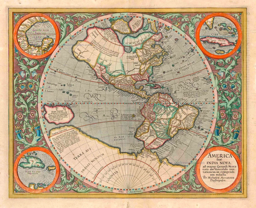
America sive India Nova ad magnae Gerardi Mercatoris avi Universalis imitationem in compendium redacta. 1623
America, by Gerard Mercator
[Item number: 131]
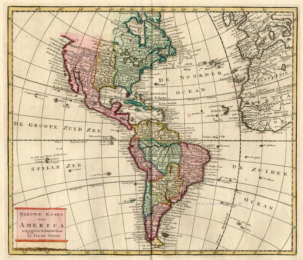
Nieuwe Kaart van America c. 1770
Antique map of America by Tirion I.
[Item number: 19194]

America. 1597
AMERICA by Giovanni Magini
[Item number: 22492]
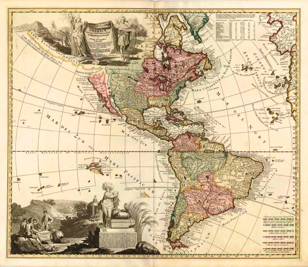
Americae tam Septentrionalis quam Meridionalis in Mappa Geographica Delineatio. c. 1700
America by A.F. Zürner, published by Petrus Schenk.
[Item number: 25715]