
AMERICA by Châtelain. 1713-1719
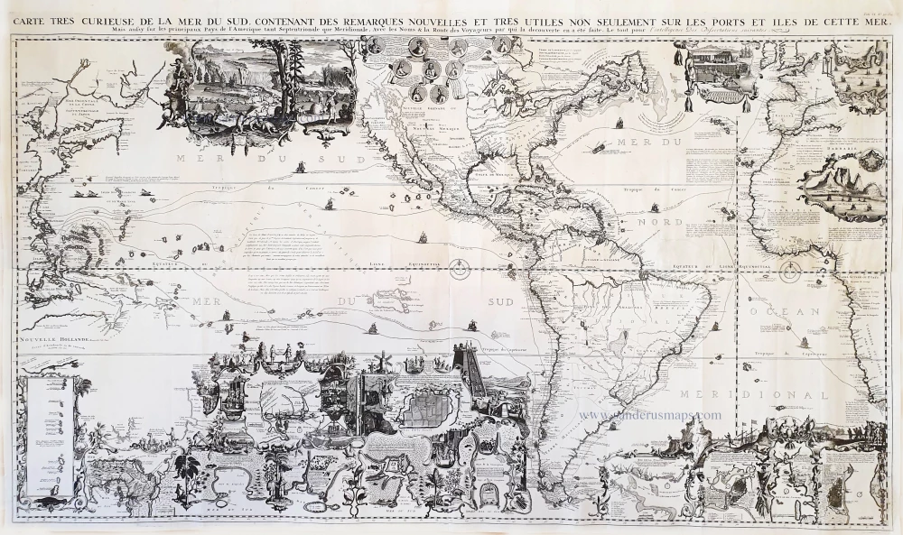
One of the most elaborately engraved maps ever published includes Southeast Asia with the north coast of Australia, America occupying a central position with California prominent as an island, to the west coast of Europe and Africa. The many inset plans, views, portraits, and scenes make this a visual encyclopaedia of the discovery and exploration of the Americas. Large vignette of Niagara Falls; others show the hunting and drying of cod. Many historical notes and explorer's tracks.
The Châtelain Family
Zacharias Châtelain (1684-1743) was a bookseller and publisher of Amsterdam. He was succeeded by his sons Zacharias jr and Henry Abraham. The Châtelain family was best known for the historical atlas Atlas Historique, ou nouvelle introduction à l’histoire…, a major work of its time. It was an encyclopaedia in seven volumes, including geography as one of its main subjects. The atlas was published in Amsterdam in seven volumes in various editions with different imprints from 1705 to 1739. An anonym person (Mr. C***) compiled the work with compositions of text, maps, plates and chronological and genealogical tables by Gueudeville, except volume 7, where H.P. Limiers took over this task. The maps were made mainly after the work of Guillaume de l'Isle.
The 1705 edition was published with the imprint “L’Honoré & Châtelain”. Later editions had the imprint: “les Frères Châtelain Libraires” or “L’Honoré & Châtelain Libraires”.
Carte tres Curieuse de la Mer du Sud, Contenant des Remarques Nouvelles et tres Utiles non Seulement sur les Ports et Iles de cette Mer, ...
Item Number: 27039 Authenticity Guarantee
Category: Antique maps > America > The Americas
Old, antique map of the Western Hemisphere showing the Pacific, the Americas and the Atlantic Ocean, by Châtelain, opposite the continental regions.
Copper engraving on four sheets joined.
Size when joined: 81 x 140cm (31.6 x 54.6 inches)
Verso: Blank
Condition: Some restored tears in the upper part.
Condition Rating: B
References: Schwartz-Ehrenberg, p.142, pl.85.
From: Atlas Historique. Amsterdam, Châtelain, 1713-1719.
One of the most elaborately engraved maps ever published includes Southeast Asia with the north coast of Australia, America occupying a central position with California prominent as an island, to the west coast of Europe and Africa. The many inset plans, views, portraits, and scenes make this a visual encyclopaedia of the discovery and exploration of the Americas. Large vignette of Niagara Falls; others show the hunting and drying of cod. Many historical notes and explorer's tracks.
The Châtelain Family
Zacharias Châtelain (1684-1743) was a bookseller and publisher of Amsterdam. He was succeeded by his sons Zacharias jr and Henry Abraham. The Châtelain family was best known for the historical atlas Atlas Historique, ou nouvelle introduction à l’histoire…, a major work of its time. It was an encyclopaedia in seven volumes, including geography as one of its main subjects. The atlas was published in Amsterdam in seven volumes in various editions with different imprints from 1705 to 1739. An anonym person (Mr. C***) compiled the work with compositions of text, maps, plates and chronological and genealogical tables by Gueudeville, except volume 7, where H.P. Limiers took over this task. The maps were made mainly after the work of Guillaume de l'Isle.
The 1705 edition was published with the imprint “L’Honoré & Châtelain”. Later editions had the imprint: “les Frères Châtelain Libraires” or “L’Honoré & Châtelain Libraires”.
Related items

America. 1597
AMERICA by Giovanni Magini
[Item number: 22492]
Big and spectacular map in excellent condition
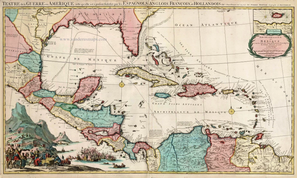
Teatre de la Guerre en Amerique, telle qu'elle est a Present Possedee par les Espagnols, Anglois, Francois, et Hollandois &c. c. 1705
Central America by Pieter Mortier (Pierre).
[Item number: 27766]