
Casablanca (Anfa) - Azemmour (Azamor) - Diu - Old Goa (Velha Goa), by Georg Braun and Frans Hogenberg. 1599


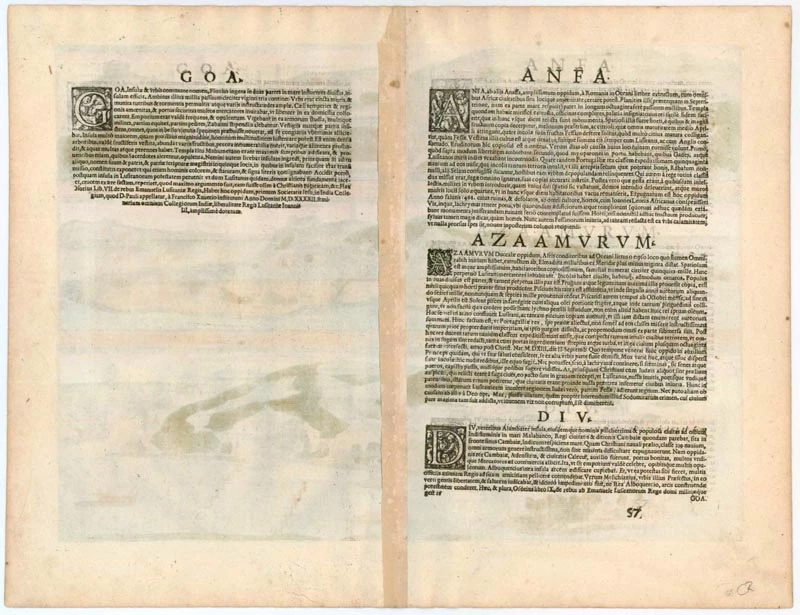


CASABLANCA (ANFA)
CAPTION: Anfa, called Anafa by some.
COMMENTARY BY BRAUN (on verso): "Anfa is a large city built by the Romans on the shores of the sea and whose location was as good as any city in all Africa. It was razed to the ground for two reasons, however, firstly, because it strove too vigorously for freedom and secondly because it caused both Cadiz and the Portuguese much trouble with its pirate ships. The King of Portugal, therefore, sent 50 well-armed ships to the city, from which the inhabitants fled with all that they could carry. The captain led his forces into the city and in one day laid waste to it, burned the houses to ashes, and razed the walls to such an extent that it has remained uninhabited right up to the present."
The engraving shows the ravaged city after 1486. The Berbers arrived in the area as early as the 7th century; their settlement subsequently evolved into the small independent Kingdom of Anfa, which in the 14th century became a major port. In 1486 Anfa was destroyed by the Portuguese, who in 1515 used its ruins to build a fort called Casablanca, after the nearby burgeoning town of the same name.
AZEMMOUR (AZAMOR)
COMMENTARY BY BRAUN (on verso): "Sufficient cereals and vegetables of all kinds grow there, although the gardens produce almost nothing but figs. There is much fish here, however, with some 6,000-7,000 ducats generated yearly. Fishing lasts from October till the end of April. The fish is commonly fried in a little oil in a pan."
Azemmour, or Azamor, lies on the left bank of the Oum Rabie River, some 72 km south of Casablanca. In 1486 the small town started paying tribute to the Portuguese and, in 1508, was conquered by them. In 1513, however, when the local governor Moulay Zayam refused to pay the tribute, the town was destroyed.
DIU
COMMENTARY BY BRAUN (on verso): "Diu is an island and also the name of a lovely town that formerly lay under the rule of the city and district of Khambat. Diu lies at the entrance to the Gulf of Cambaia in the Indian Ocean and was fought for and eventually won by the Christians with 23 ships with particular trouble and effort because Diu had the king of Cambaia, Aden and Calicut on its side."
The engraving shows Diu from a cavalier perspective from the sea. The town is encircled by secure ramparts, from which three jetties lead into the water. Rising above its severely geometric skyline are several tall towers that served as lookout posts. On the right hand of the picture, the fort at the island's eastern end was built in 1535. Diu is a small town on an island measuring 15 square miles in western India. In the naval battle of Diu, waged in 1509 against a combined fleet of Egyptian, Arab and Indian forces, it was conquered by the Portuguese. This victory secured Portugal's supremacy in the Indian Ocean.
OLD GOA (VELHA GOA)
CAPTION: Goa, the fortified city in India, came into the power of the Christians in 1509.
Goa, which lies on a peninsula, is seen across the Mandovi River delta in front of the open sea. A naval battle is depicted on the right: after the Portuguese had discovered the sea route to India in 1489, they used the enmities between the various Indian regional kingdoms to their advantage and, in 1510, conquered Goa. The city became the colonial capital of Portuguese India. Portugal would maintain possession of Goa and the surrounding area for 450 years. Old Goa, or Velha Goa, as the city is now called, is the capital of Goa, India's smallest state, with 1.45 million inhabitants.
Braun G. & Hogenberg F. and the Civitates Orbis Terrarum.
The Civitates Orbis Terrarum, also known as the 'Braun & Hogenberg', is a six-volume town atlas and the most excellent book of town views and plans ever published: 363 engravings, sometimes beautifully coloured. It was one of the best-selling works in the last quarter of the 16th century. Georg Braun, a skilled writer, wrote the text accompanying the plans and views on the verso. Many plates were engraved after the original drawings of a professional artist, Joris Hoefnagel (1542-1600). The first volume was published in Latin in 1572 and the sixth in 1617. Frans Hogenberg, a talented engraver, created the tables for volumes I through IV, and Simon van den Neuwel made those for volumes V and VI. Other contributors were cartographers Daniel Freese and Heinrich Rantzau, who provided valuable geographical information. Works by Jacob van Deventer, Sebastian Münster, and Johannes Stumpf were also used as references. Translations appeared in German and French, making the atlas accessible to a broader audience.
Since its original publication of volume 1 in 1572, the Civitates Orbis Terrarum has left an indelible mark on the history of cartography. Seven more editions followed the first volume in 1575, 1577, 1582, 1588, 1593, 1599, and 1612. Vol.2, initially released in 1575, saw subsequent editions in 1597 and 1612. The subsequent volumes, each a treasure trove of historical insights, graced the world in 1581, 1588, 1593, 1599, and 1606. The German translation of the first volume, a testament to its widespread appeal, debuted in 1574, followed by the French edition in 1575.
Several printers were involved: Theodor Graminaeus, Heinrich von Aich, Gottfried von Kempen, Johannis Sinniger, Bertram Buchholtz, and Peter von Brachel, all of whom worked in Cologne.
Georg Braun (1541-1622)
Georg Braun, the author of the text accompanying the plans and views in the Civitates Orbis Terrarum, was born in Cologne in 1541. After his studies in Cologne, he entered the Jesuit Order as a novice, indicating his commitment to learning and intellectual pursuits. In 1561, he obtained his bachelor's degree; in 1562, he received his Magister Artium, further demonstrating his academic achievements. Although he left the Jesuit Order, he continued his studies in theology, gaining a licentiate in theology. His theological background likely influenced the content and tone of the text in the Civitates Orbis Terrarum, adding a unique perspective to the work.
Frans Hogenberg (1535-1590)
Frans Hogenberg was a Flemish and German painter, engraver, and mapmaker. He was born in Mechelen as the son of Nicolaas Hogenberg.
By the end of the 1560s, Frans Hogenberg was employed upon Abraham Ortelius's Theatrum Orbis Terrarum, published in 1570; he is named an engraver of numerous maps. In 1568, he was banned from Antwerp by the Duke of Alva and travelled to London, where he stayed a few years before emigrating to Cologne. He immediately embarked on his two most important works, the Civitates, published in 1572 and the Geschichtsblätter, which appeared in several series from 1569 until about 1587.
Thanks to large-scale projects like the Geschichtsblätter and the Civitates, Hogenberg's social circumstances improved with each passing year. He died as a wealthy man in Cologne in 1590.
Anfa, quibusdam Anaffa [on sheet with] Azaamurum [and] Diu [and] Goa
Item Number: 23246 Authenticity Guarantee
Category: Antique maps > Asia > India - Ceylon
Antique print with four bird's-eye views by Braun and Hogenberg: Casablanca (Anfa) - Azemmour (Azamor) - Diu - Old Goa (Velha Goa)
Title: Anfa, quibusdam Anaffa [on sheet with] Azaamurum [and] Diu [and] Goa.
Date of the first edition: 1572.
Date of this map: 1599.
Copper engraving, printed on paper.
Size (not including margins): 340 x 470mm (13.39 x 18.5 inches).
Verso: Latin text.
Condition: Excellent, superb old colour.
Condition Rating: A+.
From: Civitates Orbis Terrarum, Liber Primus. Köln, Bertram Buchholtz, 1599. (Van der Krogt 4, 41:1.1)
CASABLANCA (ANFA)
CAPTION: Anfa, called Anafa by some.
COMMENTARY BY BRAUN (on verso): "Anfa is a large city built by the Romans on the shores of the sea and whose location was as good as any city in all Africa. It was razed to the ground for two reasons, however, firstly, because it strove too vigorously for freedom and secondly because it caused both Cadiz and the Portuguese much trouble with its pirate ships. The King of Portugal, therefore, sent 50 well-armed ships to the city, from which the inhabitants fled with all that they could carry. The captain led his forces into the city and in one day laid waste to it, burned the houses to ashes, and razed the walls to such an extent that it has remained uninhabited right up to the present."
The engraving shows the ravaged city after 1486. The Berbers arrived in the area as early as the 7th century; their settlement subsequently evolved into the small independent Kingdom of Anfa, which in the 14th century became a major port. In 1486 Anfa was destroyed by the Portuguese, who in 1515 used its ruins to build a fort called Casablanca, after the nearby burgeoning town of the same name.
AZEMMOUR (AZAMOR)
COMMENTARY BY BRAUN (on verso): "Sufficient cereals and vegetables of all kinds grow there, although the gardens produce almost nothing but figs. There is much fish here, however, with some 6,000-7,000 ducats generated yearly. Fishing lasts from October till the end of April. The fish is commonly fried in a little oil in a pan."
Azemmour, or Azamor, lies on the left bank of the Oum Rabie River, some 72 km south of Casablanca. In 1486 the small town started paying tribute to the Portuguese and, in 1508, was conquered by them. In 1513, however, when the local governor Moulay Zayam refused to pay the tribute, the town was destroyed.
DIU
COMMENTARY BY BRAUN (on verso): "Diu is an island and also the name of a lovely town that formerly lay under the rule of the city and district of Khambat. Diu lies at the entrance to the Gulf of Cambaia in the Indian Ocean and was fought for and eventually won by the Christians with 23 ships with particular trouble and effort because Diu had the king of Cambaia, Aden and Calicut on its side."
The engraving shows Diu from a cavalier perspective from the sea. The town is encircled by secure ramparts, from which three jetties lead into the water. Rising above its severely geometric skyline are several tall towers that served as lookout posts. On the right hand of the picture, the fort at the island's eastern end was built in 1535. Diu is a small town on an island measuring 15 square miles in western India. In the naval battle of Diu, waged in 1509 against a combined fleet of Egyptian, Arab and Indian forces, it was conquered by the Portuguese. This victory secured Portugal's supremacy in the Indian Ocean.
OLD GOA (VELHA GOA)
CAPTION: Goa, the fortified city in India, came into the power of the Christians in 1509.
Goa, which lies on a peninsula, is seen across the Mandovi River delta in front of the open sea. A naval battle is depicted on the right: after the Portuguese had discovered the sea route to India in 1489, they used the enmities between the various Indian regional kingdoms to their advantage and, in 1510, conquered Goa. The city became the colonial capital of Portuguese India. Portugal would maintain possession of Goa and the surrounding area for 450 years. Old Goa, or Velha Goa, as the city is now called, is the capital of Goa, India's smallest state, with 1.45 million inhabitants.
Braun G. & Hogenberg F. and the Civitates Orbis Terrarum.
The Civitates Orbis Terrarum, also known as the 'Braun & Hogenberg', is a six-volume town atlas and the most excellent book of town views and plans ever published: 363 engravings, sometimes beautifully coloured. It was one of the best-selling works in the last quarter of the 16th century. Georg Braun, a skilled writer, wrote the text accompanying the plans and views on the verso. Many plates were engraved after the original drawings of a professional artist, Joris Hoefnagel (1542-1600). The first volume was published in Latin in 1572 and the sixth in 1617. Frans Hogenberg, a talented engraver, created the tables for volumes I through IV, and Simon van den Neuwel made those for volumes V and VI. Other contributors were cartographers Daniel Freese and Heinrich Rantzau, who provided valuable geographical information. Works by Jacob van Deventer, Sebastian Münster, and Johannes Stumpf were also used as references. Translations appeared in German and French, making the atlas accessible to a broader audience.
Since its original publication of volume 1 in 1572, the Civitates Orbis Terrarum has left an indelible mark on the history of cartography. Seven more editions followed the first volume in 1575, 1577, 1582, 1588, 1593, 1599, and 1612. Vol.2, initially released in 1575, saw subsequent editions in 1597 and 1612. The subsequent volumes, each a treasure trove of historical insights, graced the world in 1581, 1588, 1593, 1599, and 1606. The German translation of the first volume, a testament to its widespread appeal, debuted in 1574, followed by the French edition in 1575.
Several printers were involved: Theodor Graminaeus, Heinrich von Aich, Gottfried von Kempen, Johannis Sinniger, Bertram Buchholtz, and Peter von Brachel, all of whom worked in Cologne.
Georg Braun (1541-1622)
Georg Braun, the author of the text accompanying the plans and views in the Civitates Orbis Terrarum, was born in Cologne in 1541. After his studies in Cologne, he entered the Jesuit Order as a novice, indicating his commitment to learning and intellectual pursuits. In 1561, he obtained his bachelor's degree; in 1562, he received his Magister Artium, further demonstrating his academic achievements. Although he left the Jesuit Order, he continued his studies in theology, gaining a licentiate in theology. His theological background likely influenced the content and tone of the text in the Civitates Orbis Terrarum, adding a unique perspective to the work.
Frans Hogenberg (1535-1590)
Frans Hogenberg was a Flemish and German painter, engraver, and mapmaker. He was born in Mechelen as the son of Nicolaas Hogenberg.
By the end of the 1560s, Frans Hogenberg was employed upon Abraham Ortelius's Theatrum Orbis Terrarum, published in 1570; he is named an engraver of numerous maps. In 1568, he was banned from Antwerp by the Duke of Alva and travelled to London, where he stayed a few years before emigrating to Cologne. He immediately embarked on his two most important works, the Civitates, published in 1572 and the Geschichtsblätter, which appeared in several series from 1569 until about 1587.
Thanks to large-scale projects like the Geschichtsblätter and the Civitates, Hogenberg's social circumstances improved with each passing year. He died as a wealthy man in Cologne in 1590.