
Aden - Mombasa - Kilwa - Sofala, by Georg Braun and Frans Hogenberg. 1635

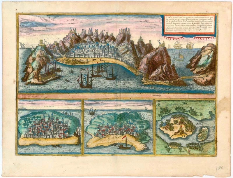
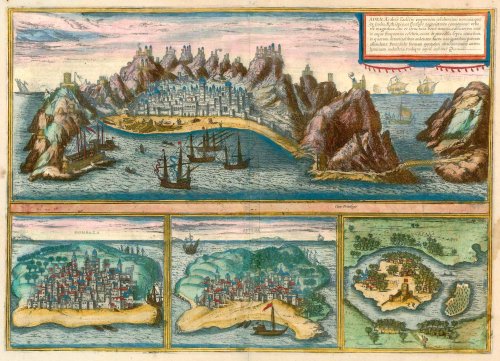

ADEN
TRANSLATION OF CARTOUCHE TEXT: Aden is a famous trade centre in Arabia, where merchants from India, Ethiopia and Persia meet. Aden is a magnificent town, well fortified due to its location and construction, famed for the beauty and number of its buildings, protected by ramparts and high mountains, on whose summits flaming torches show mariners the harbour. It was formerly a peninsula, but the human industry is now surrounded by water.
COMMENTARY BY BRAUN: "All those travelling to Mecca come here, and as soon as a ship sails into the harbour, the sultan's soldiers arrive and inquire as to where they have come from, what goods they are carrying with them, how long they have been under sail and then confiscate the mast, the sails and the like. They do that so the ships cannot leave without paying the toll."
The semicircular shape of the island is easily recognizable; fortified strongholds top the mountains around the city, and the city is lent an oriental character by its eye-catching red domes. Boats are being repaired on the shore, and the ships sailing past in the foreground also underline Aden's position as a controlling body in the Gulf. In the 13th century, according to Marco Polo, the city had a population of 80,000. With the shifting of the trade routes in the wake of the Portuguese discoveries, Aden went into an economic decline; in 1548, it was conquered for the Ottoman Empire by Piri Reis, the admiral of the Ottoman fleet. Aden is today a city in Yemen with 550,000 inhabitants.
MOMBASA
COMMENTARY BY BRAUN: "Mombasa was conquered by force by the Christians in 1505. When Francisco de Almeida was sent to India by the King of Portugal to levy duties on the inhabitants, the Africans rebelled violently against him. Consequently, the Christians destroyed the town and burned it to the ground. The ruler escaped with his life, the other inhabitants were all killed."
The illustration shows a stereotypical view of a small town on an island. While the architecture, with its tall towers and red roofs, is not very African, the palm trees are more typical of the local vegetation. The picture and the description suggest that little was known about Mombasa. The Portuguese explorer Vasco da Gama reached the town in 1498 and was conquered by Portuguese troops under Francisco de Almeida in 1505. Mombasa lies on Mombasa Island off the east coast of Africa and is today Kenya's second-largest city.
KILWA (QUILOA)
COMMENTARY BY BRAUN: "Quiloa is a pretty little town in Africa, situated on an island close to the mainland, whose king is a Muslim and a great enemy of all Christians. In 1505 Francisco de Almeida put in at his town with the Portuguese fleet and summoned the king to him. The latter said that he was ill, however, so he could use the time to arm himself for battle. 700 Portuguese, therefore, made ready to storm the town, whereupon they soon conquered it, put the king to flight, installed a new political regime and placed it under the authority of the King of Portugal."
The view of Kilwa (Port. Quiloa) shows a small town of foreign and Mediterranean-seeming houses in a forest of palm trees on an island. Kilwa Kisiwani (Swahili for "the town on the island") lies just 1.5 km off the east coast of Africa and today belongs to Tanzania. In 1505 the town was taken by the Portuguese under the command of Francisco de Almeida, but Portuguese dominion lasted only until 1512. The town remained a major trading port until the 18th century, but only ruins survive today.
SOFALA (CEFALA)
COMMENTARY BY BRAUN: "Cefala is an island in Africa discovered as late as 1500; it measures three miles long, one mile wide. Has two villages with not a small number of houses and a palace that formerly belonged to the King of Quiloa".
Today a simple fishing village in Mozambique's Sofala province, Cefala or Sofala, was once an important trading port at the mouth of the Sofala River in Portuguese East Africa. The Portuguese took it in 1505; the occupiers built a fort and used the harbour to convey away the gold mined in the area. Tomé Lopez, who sailed to Africa with Vasco da Gama, believed that he had found the biblical city of Ophir in Sofala, from where King Solomon obtained his gold. This legend persisted right up to the 20th century. (Taschen)
Braun G. & Hogenberg F. and the Civitates Orbis Terrarum.
The Civitates Orbis Terrarum, also known as the 'Braun & Hogenberg', is a six-volume town atlas and the most excellent book of town views and plans ever published: 363 engravings, sometimes beautifully coloured. It was one of the best-selling works in the last quarter of the 16th century. Georg Braun, a skilled writer, wrote the text accompanying the plans and views on the verso. Many plates were engraved after the original drawings of a professional artist, Joris Hoefnagel (1542-1600). The first volume was published in Latin in 1572 and the sixth in 1617. Frans Hogenberg, a talented engraver, created the tables for volumes I through IV, and Simon van den Neuwel made those for volumes V and VI. Other contributors were cartographers Daniel Freese and Heinrich Rantzau, who provided valuable geographical information. Works by Jacob van Deventer, Sebastian Münster, and Johannes Stumpf were also used as references. Translations appeared in German and French, making the atlas accessible to a broader audience.
Since its original publication of volume 1 in 1572, the Civitates Orbis Terrarum has left an indelible mark on the history of cartography. Seven more editions followed the first volume in 1575, 1577, 1582, 1588, 1593, 1599, and 1612. Vol.2, initially released in 1575, saw subsequent editions in 1597 and 1612. The subsequent volumes, each a treasure trove of historical insights, graced the world in 1581, 1588, 1593, 1599, and 1606. The German translation of the first volume, a testament to its widespread appeal, debuted in 1574, followed by the French edition in 1575.
Several printers were involved: Theodor Graminaeus, Heinrich von Aich, Gottfried von Kempen, Johannis Sinniger, Bertram Buchholtz, and Peter von Brachel, all of whom worked in Cologne.
Georg Braun (1541-1622)
Georg Braun, the author of the text accompanying the plans and views in the Civitates Orbis Terrarum, was born in Cologne in 1541. After his studies in Cologne, he entered the Jesuit Order as a novice, indicating his commitment to learning and intellectual pursuits. In 1561, he obtained his bachelor's degree; in 1562, he received his Magister Artium, further demonstrating his academic achievements. Although he left the Jesuit Order, he continued his studies in theology, gaining a licentiate in theology. His theological background likely influenced the content and tone of the text in the Civitates Orbis Terrarum, adding a unique perspective to the work.
Frans Hogenberg (1535-1590)
Frans Hogenberg was a Flemish and German painter, engraver, and mapmaker. He was born in Mechelen as the son of Nicolaas Hogenberg.
By the end of the 1560s, Frans Hogenberg was employed upon Abraham Ortelius's Theatrum Orbis Terrarum, published in 1570; he is named an engraver of numerous maps. In 1568, he was banned from Antwerp by the Duke of Alva and travelled to London, where he stayed a few years before emigrating to Cologne. He immediately embarked on his two most important works, the Civitates, published in 1572 and the Geschichtsblätter, which appeared in several series from 1569 until about 1587.
Thanks to large-scale projects like the Geschichtsblätter and the Civitates, Hogenberg's social circumstances improved with each passing year. He died as a wealthy man in Cologne in 1590.
Aden, Arabiae Foelicis Emporium Celeberrimi Nominis, quo ex India, Aethiopia ... [on sheet with] Mombaza [and] Quiloa [and] Cefala.
Item Number: 23242 Authenticity Guarantee
Category: Antique maps > Asia > Middle East
Old, antique bird’s-eye view plan of Aden - Mombasa - Kilwa - Sofala, by Georg Braun & Frans Hogenberg.
Title: Aden, Arabiae Foelicis Emporium Celeberrimi Nominis, quo ex India, Aethiopia ... [on sheet with] Mombaza [and] Quiloa [and] Cefala.
Cum Privilegio.
Date of the first edition: 1572.
Date of this map: 1635.
Copper engraving, printed on paper.
Size (not including margins): 340 x 480mm (13.39 x 18.9 inches).
Verso: Latin text.
Condition: Original coloured, excellent.
Condition Rating: A+.
From: Civitates Orbis Terrarum, Liber Primus. Köln, Petrus von Brachel, 1635 (Van der Krogt 4, 41:1.1)
ADEN
TRANSLATION OF CARTOUCHE TEXT: Aden is a famous trade centre in Arabia, where merchants from India, Ethiopia and Persia meet. Aden is a magnificent town, well fortified due to its location and construction, famed for the beauty and number of its buildings, protected by ramparts and high mountains, on whose summits flaming torches show mariners the harbour. It was formerly a peninsula, but the human industry is now surrounded by water.
COMMENTARY BY BRAUN: "All those travelling to Mecca come here, and as soon as a ship sails into the harbour, the sultan's soldiers arrive and inquire as to where they have come from, what goods they are carrying with them, how long they have been under sail and then confiscate the mast, the sails and the like. They do that so the ships cannot leave without paying the toll."
The semicircular shape of the island is easily recognizable; fortified strongholds top the mountains around the city, and the city is lent an oriental character by its eye-catching red domes. Boats are being repaired on the shore, and the ships sailing past in the foreground also underline Aden's position as a controlling body in the Gulf. In the 13th century, according to Marco Polo, the city had a population of 80,000. With the shifting of the trade routes in the wake of the Portuguese discoveries, Aden went into an economic decline; in 1548, it was conquered for the Ottoman Empire by Piri Reis, the admiral of the Ottoman fleet. Aden is today a city in Yemen with 550,000 inhabitants.
MOMBASA
COMMENTARY BY BRAUN: "Mombasa was conquered by force by the Christians in 1505. When Francisco de Almeida was sent to India by the King of Portugal to levy duties on the inhabitants, the Africans rebelled violently against him. Consequently, the Christians destroyed the town and burned it to the ground. The ruler escaped with his life, the other inhabitants were all killed."
The illustration shows a stereotypical view of a small town on an island. While the architecture, with its tall towers and red roofs, is not very African, the palm trees are more typical of the local vegetation. The picture and the description suggest that little was known about Mombasa. The Portuguese explorer Vasco da Gama reached the town in 1498 and was conquered by Portuguese troops under Francisco de Almeida in 1505. Mombasa lies on Mombasa Island off the east coast of Africa and is today Kenya's second-largest city.
KILWA (QUILOA)
COMMENTARY BY BRAUN: "Quiloa is a pretty little town in Africa, situated on an island close to the mainland, whose king is a Muslim and a great enemy of all Christians. In 1505 Francisco de Almeida put in at his town with the Portuguese fleet and summoned the king to him. The latter said that he was ill, however, so he could use the time to arm himself for battle. 700 Portuguese, therefore, made ready to storm the town, whereupon they soon conquered it, put the king to flight, installed a new political regime and placed it under the authority of the King of Portugal."
The view of Kilwa (Port. Quiloa) shows a small town of foreign and Mediterranean-seeming houses in a forest of palm trees on an island. Kilwa Kisiwani (Swahili for "the town on the island") lies just 1.5 km off the east coast of Africa and today belongs to Tanzania. In 1505 the town was taken by the Portuguese under the command of Francisco de Almeida, but Portuguese dominion lasted only until 1512. The town remained a major trading port until the 18th century, but only ruins survive today.
SOFALA (CEFALA)
COMMENTARY BY BRAUN: "Cefala is an island in Africa discovered as late as 1500; it measures three miles long, one mile wide. Has two villages with not a small number of houses and a palace that formerly belonged to the King of Quiloa".
Today a simple fishing village in Mozambique's Sofala province, Cefala or Sofala, was once an important trading port at the mouth of the Sofala River in Portuguese East Africa. The Portuguese took it in 1505; the occupiers built a fort and used the harbour to convey away the gold mined in the area. Tomé Lopez, who sailed to Africa with Vasco da Gama, believed that he had found the biblical city of Ophir in Sofala, from where King Solomon obtained his gold. This legend persisted right up to the 20th century. (Taschen)
Braun G. & Hogenberg F. and the Civitates Orbis Terrarum.
The Civitates Orbis Terrarum, also known as the 'Braun & Hogenberg', is a six-volume town atlas and the most excellent book of town views and plans ever published: 363 engravings, sometimes beautifully coloured. It was one of the best-selling works in the last quarter of the 16th century. Georg Braun, a skilled writer, wrote the text accompanying the plans and views on the verso. Many plates were engraved after the original drawings of a professional artist, Joris Hoefnagel (1542-1600). The first volume was published in Latin in 1572 and the sixth in 1617. Frans Hogenberg, a talented engraver, created the tables for volumes I through IV, and Simon van den Neuwel made those for volumes V and VI. Other contributors were cartographers Daniel Freese and Heinrich Rantzau, who provided valuable geographical information. Works by Jacob van Deventer, Sebastian Münster, and Johannes Stumpf were also used as references. Translations appeared in German and French, making the atlas accessible to a broader audience.
Since its original publication of volume 1 in 1572, the Civitates Orbis Terrarum has left an indelible mark on the history of cartography. Seven more editions followed the first volume in 1575, 1577, 1582, 1588, 1593, 1599, and 1612. Vol.2, initially released in 1575, saw subsequent editions in 1597 and 1612. The subsequent volumes, each a treasure trove of historical insights, graced the world in 1581, 1588, 1593, 1599, and 1606. The German translation of the first volume, a testament to its widespread appeal, debuted in 1574, followed by the French edition in 1575.
Several printers were involved: Theodor Graminaeus, Heinrich von Aich, Gottfried von Kempen, Johannis Sinniger, Bertram Buchholtz, and Peter von Brachel, all of whom worked in Cologne.
Georg Braun (1541-1622)
Georg Braun, the author of the text accompanying the plans and views in the Civitates Orbis Terrarum, was born in Cologne in 1541. After his studies in Cologne, he entered the Jesuit Order as a novice, indicating his commitment to learning and intellectual pursuits. In 1561, he obtained his bachelor's degree; in 1562, he received his Magister Artium, further demonstrating his academic achievements. Although he left the Jesuit Order, he continued his studies in theology, gaining a licentiate in theology. His theological background likely influenced the content and tone of the text in the Civitates Orbis Terrarum, adding a unique perspective to the work.
Frans Hogenberg (1535-1590)
Frans Hogenberg was a Flemish and German painter, engraver, and mapmaker. He was born in Mechelen as the son of Nicolaas Hogenberg.
By the end of the 1560s, Frans Hogenberg was employed upon Abraham Ortelius's Theatrum Orbis Terrarum, published in 1570; he is named an engraver of numerous maps. In 1568, he was banned from Antwerp by the Duke of Alva and travelled to London, where he stayed a few years before emigrating to Cologne. He immediately embarked on his two most important works, the Civitates, published in 1572 and the Geschichtsblätter, which appeared in several series from 1569 until about 1587.
Thanks to large-scale projects like the Geschichtsblätter and the Civitates, Hogenberg's social circumstances improved with each passing year. He died as a wealthy man in Cologne in 1590.