
Antique map - Bird's-eye view of Syria - Damascus by Braun & Hogenberg. 1593


Braun G. & Hogenberg F. and the Civitates Orbis Terrarum.
The Civitates Orbis Terrarum, also known as the 'Braun & Hogenberg', is a six-volume town atlas and the most excellent book of town views and plans ever published: 363 engravings, sometimes beautifully coloured. It was one of the best-selling works in the last quarter of the 16th century. Georg Braun, a skilled writer, wrote the text accompanying the plans and views on the verso. Many plates were engraved after the original drawings of a professional artist, Joris Hoefnagel (1542-1600). The first volume was published in Latin in 1572 and the sixth in 1617. Frans Hogenberg, a talented engraver, created the tables for volumes I through IV, and Simon van den Neuwel made those for volumes V and VI. Other contributors were cartographers Daniel Freese and Heinrich Rantzau, who provided valuable geographical information. Works by Jacob van Deventer, Sebastian Münster, and Johannes Stumpf were also used as references. Translations appeared in German and French, making the atlas accessible to a broader audience.
Since its original publication of volume 1 in 1572, the Civitates Orbis Terrarum has left an indelible mark on the history of cartography. Seven more editions followed the first volume in 1575, 1577, 1582, 1588, 1593, 1599, and 1612. Vol.2, initially released in 1575, saw subsequent editions in 1597 and 1612. The subsequent volumes, each a treasure trove of historical insights, graced the world in 1581, 1588, 1593, 1599, and 1606. The German translation of the first volume, a testament to its widespread appeal, debuted in 1574, followed by the French edition in 1575.
Several printers were involved: Theodor Graminaeus, Heinrich von Aich, Gottfried von Kempen, Johannis Sinniger, Bertram Buchholtz, and Peter von Brachel, all of whom worked in Cologne.
Georg Braun (1541-1622)
Georg Braun, the author of the text accompanying the plans and views in the Civitates Orbis Terrarum, was born in Cologne in 1541. After his studies in Cologne, he entered the Jesuit Order as a novice, indicating his commitment to learning and intellectual pursuits. In 1561, he obtained his bachelor's degree; in 1562, he received his Magister Artium, further demonstrating his academic achievements. Although he left the Jesuit Order, he continued his studies in theology, gaining a licentiate in theology. His theological background likely influenced the content and tone of the text in the Civitates Orbis Terrarum, adding a unique perspective to the work.
Frans Hogenberg (1535-1590)
Frans Hogenberg was a Flemish and German painter, engraver, and mapmaker. He was born in Mechelen as the son of Nicolaas Hogenberg.
By the end of the 1560s, Frans Hogenberg was employed upon Abraham Ortelius's Theatrum Orbis Terrarum, published in 1570; he is named an engraver of numerous maps. In 1568, he was banned from Antwerp by the Duke of Alva and travelled to London, where he stayed a few years before emigrating to Cologne. He immediately embarked on his two most important works, the Civitates, published in 1572 and the Geschichtsblätter, which appeared in several series from 1569 until about 1587.
Thanks to large-scale projects like the Geschichtsblätter and the Civitates, Hogenberg's social circumstances improved with each passing year. He died as a wealthy man in Cologne in 1590.
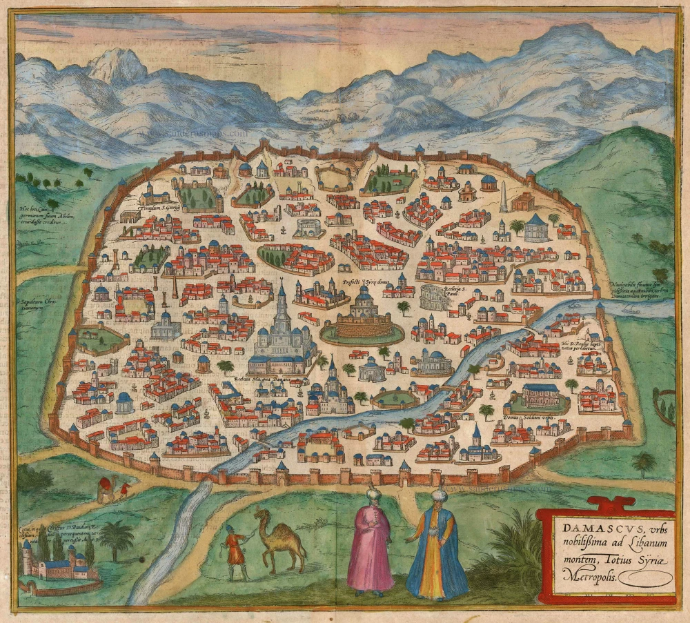
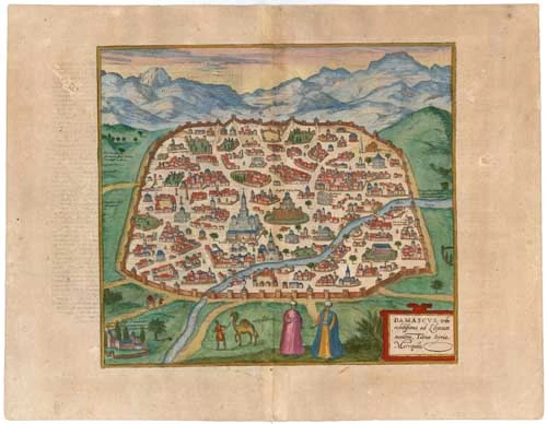
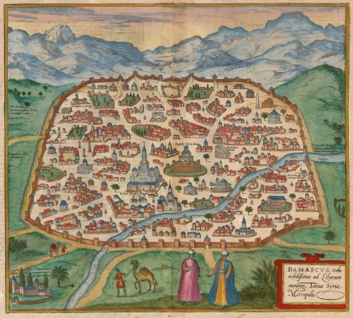
Damascus, Urbs Nobilissima ad Libanum Montem, Totius Syriae Metropolis
Item Number: 16953 Authenticity Guarantee
Category: Antique maps > Asia > Middle East
Antique map - Bird's-eye view of Syria - Damascus by Braun & Hogenberg
TRANSLATION OF CARTOUCHE TEXT: Damascus, famous city at the foot of Lebanon, capital of all Syria.
COMMENTARY BY BRAUN (on verso): "A stone's throw away from Damascus is the place where Christ appeared to Paul as he persecuted the Christians, and called out to him: "Saul, Saul, why are you persecuting Me?" On this site Christians now have their cemetery and a church. On the other side of the town, roughly an Italian mile away, a church can be seen that occupies the spot where Cain struck dead the pious Abel. Moreover, Holy Scripture, as well as all learned theologians, relates that God created our first parents, Adam and Eve, in the area around this city."
The plate depicts Damascus in a bird's-eye view. The Umayyaden Mosques, erected as early as AD 705, can be seen inside the city walls, at the centre. Two staffage figures wearing turbans and kaftans can be seen standing in the foreground. The sites mentioned in the text can be identified to the left outside the city walls, in the lower left the memorial church, where Christ appeared to Paul, above this the Christian cemetery and in the upper left the spot where Cain struck Abel dead. Damascus was, owing to its location in a large oasis in an otherwise extremely arid region, settled very early, around 5000 BC. It belonged many years to the Egyptian Empire, but was then captured by Alexander the Great and, following the conquest of the Romans by Marcus Antonius, returned to Egypt. In AD 636 the town was occupied by the Arabs and remained under their rule until the Ottomans took it in 1516. For Christian Europe, Damascus was of little relevance, but it was marvelled at for its wealth and peace, and considered the cradle of civilization. (Taschen)
Date of the first edition: 1575
Date of this map: 1593
Copper engraving
Size: 32 x 35.5cm (12.5 x 13.8 inches)
Verso text: Latin
Condition: Old coloured, excellent..
Condition Rating: A
References: Van der Krogt 4, 993; Taschen, Braun and Hogenberg, p.194.
From: Civitates Orbis Terrarum, ... Part 2: De Praecipuis, Totius Universi Urbibus, Liber Secundus. Köln, Gottfried von Kempen, 1593. (Van der Krogt 4, 41:1.2)
Braun G. & Hogenberg F. and the Civitates Orbis Terrarum.
The Civitates Orbis Terrarum, also known as the 'Braun & Hogenberg', is a six-volume town atlas and the most excellent book of town views and plans ever published: 363 engravings, sometimes beautifully coloured. It was one of the best-selling works in the last quarter of the 16th century. Georg Braun, a skilled writer, wrote the text accompanying the plans and views on the verso. Many plates were engraved after the original drawings of a professional artist, Joris Hoefnagel (1542-1600). The first volume was published in Latin in 1572 and the sixth in 1617. Frans Hogenberg, a talented engraver, created the tables for volumes I through IV, and Simon van den Neuwel made those for volumes V and VI. Other contributors were cartographers Daniel Freese and Heinrich Rantzau, who provided valuable geographical information. Works by Jacob van Deventer, Sebastian Münster, and Johannes Stumpf were also used as references. Translations appeared in German and French, making the atlas accessible to a broader audience.
Since its original publication of volume 1 in 1572, the Civitates Orbis Terrarum has left an indelible mark on the history of cartography. Seven more editions followed the first volume in 1575, 1577, 1582, 1588, 1593, 1599, and 1612. Vol.2, initially released in 1575, saw subsequent editions in 1597 and 1612. The subsequent volumes, each a treasure trove of historical insights, graced the world in 1581, 1588, 1593, 1599, and 1606. The German translation of the first volume, a testament to its widespread appeal, debuted in 1574, followed by the French edition in 1575.
Several printers were involved: Theodor Graminaeus, Heinrich von Aich, Gottfried von Kempen, Johannis Sinniger, Bertram Buchholtz, and Peter von Brachel, all of whom worked in Cologne.
Georg Braun (1541-1622)
Georg Braun, the author of the text accompanying the plans and views in the Civitates Orbis Terrarum, was born in Cologne in 1541. After his studies in Cologne, he entered the Jesuit Order as a novice, indicating his commitment to learning and intellectual pursuits. In 1561, he obtained his bachelor's degree; in 1562, he received his Magister Artium, further demonstrating his academic achievements. Although he left the Jesuit Order, he continued his studies in theology, gaining a licentiate in theology. His theological background likely influenced the content and tone of the text in the Civitates Orbis Terrarum, adding a unique perspective to the work.
Frans Hogenberg (1535-1590)
Frans Hogenberg was a Flemish and German painter, engraver, and mapmaker. He was born in Mechelen as the son of Nicolaas Hogenberg.
By the end of the 1560s, Frans Hogenberg was employed upon Abraham Ortelius's Theatrum Orbis Terrarum, published in 1570; he is named an engraver of numerous maps. In 1568, he was banned from Antwerp by the Duke of Alva and travelled to London, where he stayed a few years before emigrating to Cologne. He immediately embarked on his two most important works, the Civitates, published in 1572 and the Geschichtsblätter, which appeared in several series from 1569 until about 1587.
Thanks to large-scale projects like the Geschichtsblätter and the Civitates, Hogenberg's social circumstances improved with each passing year. He died as a wealthy man in Cologne in 1590.