
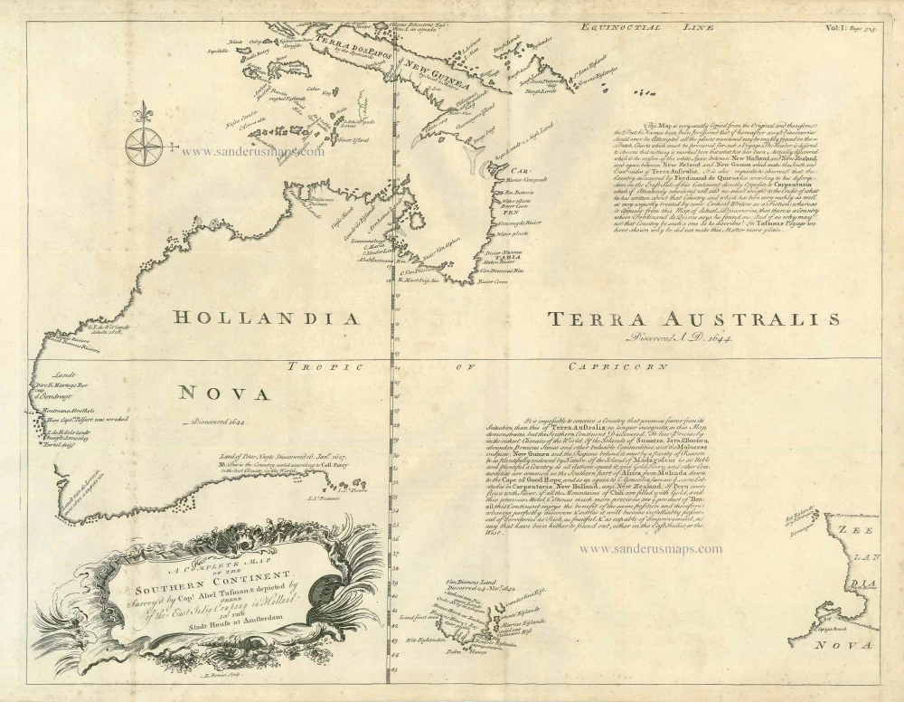
Antique map of Australia by Bowen E. 1744.
Emanuel Bowen (c. 1693/94 – 1767)
Emanuel Bowen was an accomplished engraver who became a leading mid-century map and atlas-maker, engraving many maps for contemporary magazines and books. He achieved the unique distinction of becoming Royal Mapmaker to King George II of Great Britain and Louis XV of France.
The earliest work associated with Bowen, the Britannia Depicta (1720), is essentially a strip road atlas based on Ogilby’s maps, with a set of small county maps. Bowen’s co-publisher was Thomas Bowles, and the antiquary who compiled and edited the text was John Owen. The maps are, therefore, sometimes known as ‘Owen-Bowens’.
By 1726 he was noted as one of the leading London engravers. He published A Complete System of Geography, 1744–47; an English Atlas, with a new set of maps, 1745; a Complete Atlas ... in sixty-eight Maps, 1752; Atlas Minimus, 1758; and a series of separate maps of the English counties, of Germany, Asia Minor, and Persia, between 1736 and 1776.
He died in poverty in 1767. His son, Thomas Bowen (1733-1790) would carry on the business until he died in 1790.
A Complete Map of the Southern Continent. Survey'd by Capt. Abel Tasman & Depicted by Order of the East India Company in Holland in the Stadt House at Amsterdam
Item Number: 23475 Authenticity Guarantee
Category: Antique maps > Asia > Southeast Asia
Map of Australia, oriented to the North
Copper engraving
Size: 37.5 x 48.5cm (14.6 x 18.9 inches)
Verso: Blank
Condition: Minimal spotting, else excellent.
Condition Rating: A
References: Tooley (Australia) 241, pl.12.
From: Harris John, Navigantium atque Itinerantium Bibliotheca. London, 1744.
Emanuel Bowen (c. 1693/94 – 1767)
Emanuel Bowen was an accomplished engraver who became a leading mid-century map and atlas-maker, engraving many maps for contemporary magazines and books. He achieved the unique distinction of becoming Royal Mapmaker to King George II of Great Britain and Louis XV of France.
The earliest work associated with Bowen, the Britannia Depicta (1720), is essentially a strip road atlas based on Ogilby’s maps, with a set of small county maps. Bowen’s co-publisher was Thomas Bowles, and the antiquary who compiled and edited the text was John Owen. The maps are, therefore, sometimes known as ‘Owen-Bowens’.
By 1726 he was noted as one of the leading London engravers. He published A Complete System of Geography, 1744–47; an English Atlas, with a new set of maps, 1745; a Complete Atlas ... in sixty-eight Maps, 1752; Atlas Minimus, 1758; and a series of separate maps of the English counties, of Germany, Asia Minor, and Persia, between 1736 and 1776.
He died in poverty in 1767. His son, Thomas Bowen (1733-1790) would carry on the business until he died in 1790.