
Old antique map of the East Indian Archipelago by Hondius J. 1623
The item displayed on this page has been sold. However, we have a similar map in stock:
East Indian Archipelago by Jodocus Hondius. 1630
Insulae Indiae Orientalis Praecipuae, in quibus ...
[Item number: 29863]
new

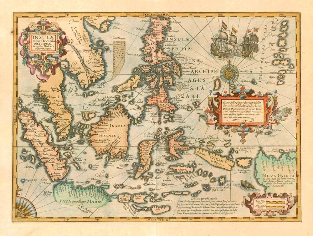


Two beautiful new maps of Southeast Asia were created by the Dutch mapmaker Jodocus Hondius for an enlarged issue of the Mercator Atlas of 1606. One covered the Indian Ocean region and the other focused on the islands. Geographically, Hondius largely followed the Bartolomeu Lasso pattern. The Insulae Indiae Orientalis is one of the few maps to show any trace of Francis Drake's presence in Southeast Asia.
Insulae Indiae Orientalis Praecipuae, in quibus Moluccae celeberrimae sunt.
Item Number: 10358 Authenticity Guarantee
Category: Antique maps > Asia > Southeast Asia
Antique old map of the East Indian Archipelago by J. Hondius
Date of the first edition: 1606
Date of this map: 1623
Copper engraving
Size: 34.5 x 48cm (13.5 x 18.7 inches)
Verso text: Latin
Condition: Contemporary old coloured, excellent.
Condition Rating: A
References: Van der Krogt 1, 8500:1A; Suarez (Southeast Asia), p. 193; Clancy, p.69 Map 5.13.
From: Gerardi Mercatoris - Atlas sive Cosmographicae Meditationes de Fabrica Mundi et Fabricati Figura. Amsterdam, H. Hondius, 1623. (Van der Krogt 1, 105)
Two beautiful new maps of Southeast Asia were created by the Dutch mapmaker Jodocus Hondius for an enlarged issue of the Mercator Atlas of 1606. One covered the Indian Ocean region and the other focused on the islands. Geographically, Hondius largely followed the Bartolomeu Lasso pattern. The Insulae Indiae Orientalis is one of the few maps to show any trace of Francis Drake's presence in Southeast Asia.
Two beautiful new maps of Southeast Asia were created by the Dutch mapmaker Jodocus Hondius for an enlarged issue of the Mercator Atlas of 1606. One covered the Indian Ocean region and the other focused on the islands. Geographically, Hondius largely followed the Bartolomeu Lasso pattern. The Insulae Indiae Orientalis is one of the few maps to show any trace of Francis Drake's presence in Southeast Asia.
