
Antique map - bird's-eye view of Constantinople (Istanbul) by Braun and Hogenberg 1572

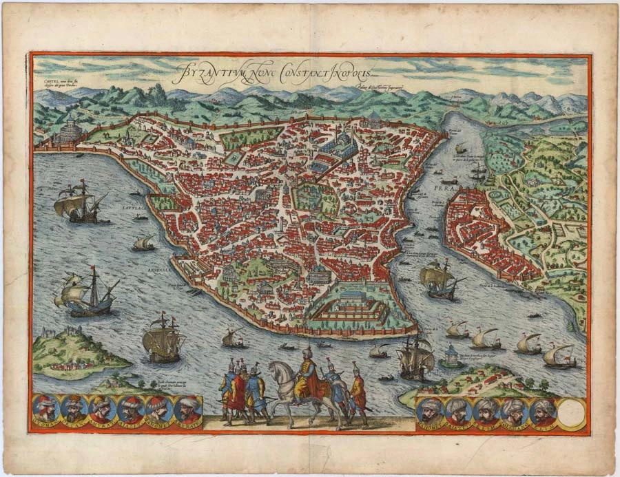
Byzantium nunc Constantinopolis.
Item Number: 6477 Authenticity Guarantee
Category: Antique maps > Asia > Turkey - Cyprus
Antique map - bird's-eye view of Constantinople (Istanbul) by Braun and Hogenberg. The city view include monuments of Saint Sophia, Topkapi Palace. Twelve vignettes of Ottoman sultans line the bottom margin, including portraits of Soliman the Magnificent and Selim. Numerous ships in Bosphorus and Golden Horn. Mounted Sultan with entourage at bottom center.
CAPTION: Byzanz, now Constantinople.
COMMENTARY BY BRAUN: "Byzantium is a central place, because no one can travel to Asia or Europe without the city's consent, since for one part of the world the city is like a bridge or a gate. It is bound by the sea on three sides: to the north the arm of the Bosporus, which belongs to Europe and is called Cornus (Horn). To the east the Bosporus Strait, to the south the Sea of Marmara."
Constantinople is shown in bird's-eye perspective from the east. The view looks directly down upon the new palace within its 200-acre park that was built by Sultan Mehmed II in 1453, immediately after the conquest of the city; since the 18th century it has been called the Topkapi palace. Beside it on the left stands Hagia Sofia, the coronation church of the Byzantine emperors. It was turned into a mosque on the day that Constantinople fell and subsequently given four minarets, still visible on the plate. Further left again are Roman ruins including obelisks and an amphitheatre. The city was founded in 668 BC under the name of Byzantion (Byzantium) by the Greeks, for whom the Bosporus Strait was already of strategic importance. Incorporated into the Roman Empire under Vespasian, in AD 324 the city was made the capital of the Eastern Empire by Emperor Constantine and renamed Constantinople. The 11 medallions along the lower edge contain the portraits of all the sultans, from the founder of the Ottoman Empire, Osman I, up to the current ruler of the day, Selim II. The name Istanbul was already in colloquial use in Ottoman times, but would replace Constantinople as the city's official name only in 1930. With a population of some ten million, Istanbul is today the biggest city in Turkey. (Taschen)
Date of the first edition: 1572
Date of this map: 1572
Copper engraving
Size: 33 x 48.5cm (12.9 x 18.8 inches)
Verso text: Latin
Condition: Old coloured, faint, small printers crease, two closed tears, one running 5 cm into the image and one in the bottom margin.
Condition Rating: B
References: Van der Krogt 4, 1912, State 1 (with last medaillon blank and without privilege).
From: Civitates Orbis Terrarum, Liber Primus. Cologne, Theodor Graminaeus, 1572.. (Van der Krogt 4, 41:0)