
Bosphorus Straits, by Coronelli V.M. 1691
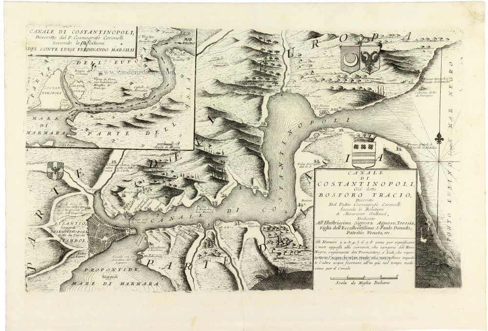
A historically significant map of Constantinople and the Bosphorus, combining Coronelli's accomplished cartography with the pioneering scientific observations of Luigi Ferdinando Marsigli.
The map depicts the Bosphorus, the strategically important strait connecting the Black Sea with the Sea of Marmara and separating the European and Asian continents. Constantinople is prominently represented at the southern entrance to the strait, with its fortified walls, urban layout and natural harbour of the Golden Horn clearly delineated.
The surrounding landscape is shown in an attractive pictorial style, with hills, forests, villages, fortifications, castles and coastal settlements carefully identified. Particular attention is devoted to the numerous promontories and narrow passages along the Bosphorus, reflecting its importance for navigation and military control.
An inset map in the upper left corner provides a more general representation of the waterway, extending from the Black Sea to the Sea of Marmara. Based on information supplied by Count Luigi Ferdinando Marsigli, this supplementary chart illustrates the geographical relationship between Constantinople, the Bosphorus and the surrounding region.
The main map is accompanied by an elaborate title panel, dedicated to Agnese Teresa, daughter of the Venetian patrician Paolo Donado. Below the dedication, an explanatory note discusses the currents flowing through the Bosphorus, with numbered indications corresponding to particular coastal locations.
The Bosphorus had been one of the most strategically important waterways in the Mediterranean and Black Sea region since antiquity. Under the Ottoman Empire, Constantinople controlled the maritime passage between the Black Sea and the Mediterranean, making the strait essential to commerce, naval operations and international diplomacy.
The map is especially interesting for its association with Luigi Ferdinando Marsigli (1658–1730), the Italian military engineer, naturalist and scholar whose investigations into the currents and physical characteristics of the Bosphorus contributed significantly to the development of early oceanography.
Coronelli's representation combines geographical observation, historical information and decorative engraving. The depiction of the opposing shores of Europe and Asia, along with detailed identifications of settlements and coastal landmarks, provides a valuable record of the region's late seventeenth-century geography.
Vincenzo Coronelli (1650-1718)
Vincenzo Coronelli was born in Venice on 16 August 1650 and primarily brought up in Ravenna. He returned to Venice in 1665 and joined the convent of the Minor Conventuals. Five years later, he was sent to Rome to study, and by 1673, he was already a doctor of theology.
Having achieved fame by constructing two globes for the Duke of Parma, he was invited to Paris for three years in 1681 and made two enormous examples for Louis XIV. On his return to Venice, he assiduously collected cartographic material and founded the Academy of the Argonauts. In 1685, he was appointed Cosmographer to the Republic of Venice and authorised to publish a large atlas. He became a geography lecturer at the University of Venice and brought out an Atlante Veneto the following year.
In 1696, he visited Germany, Holland and southern England. During intervals in compiling his vast encyclopaedia, he continued with cartographic projects up to 1709. He died in his native Venice on 9 December 1718.
Coronelli became famous for his globes. In addition, he was a renowned encyclopaedist, mapmaker and geographer. Most of his maps and other material are gathered in his Atlante Veneto (13 vols, 1690-1705). The first volume, subtitled Descrizione generale istorica geografica, was his masterpiece, planned as an extension of Blaeu’s atlas.
Other volumes of the atlas which contain maps are Isolario, two parts (1696-8), with detailed maps and plans, mostly of islands; Corso geografico, two parts based on the edition 1694-7; Libro de’ globi (1697); and Lo Specchio del Mare, a reprint of Levanto's Lo Specchio del Mare Mediterraneo of 1664.
The other vital aspects of his mapping are those arising from the Venetian conquest and his travels. His most extensive military compilation was the Teatro della Guerra, in more than 30 volumes.
Canale di Constantinopoli, Già detto Bosforo Tracio,
Item Number: 33371 new Authenticity Guarantee
Category: Antique maps > Asia > Turkey - Cyprus
Bosohrus Straits, by Coronelli V.M.
With an inset map.
Title: Canale di Constantinopoli, Già detto Bosforo Tracio,
Descritto Dal Padre Cosmografo Coronelli Secondo le Relationi di Monsieur Galland, ...
Date: 1691.
Copper engraving, printed on paper.
Image size: 260 x 430mm (10¼ x 17 inches).
Sheet size: 325 x 475mm (12¾ x 18¾ inches).
Verso: Blank.
Condition: Excellent.
Condition Rating: A+.
From: Atlante Veneto, nel quale si contiene la descrittione... degl' Imperii, Regni, Provincie, e Stati dell' Universo. Venice: Girolamo Albrizzi, 1691. Shirley (Brit.Lib.), T.CORO-7a
A historically significant map of Constantinople and the Bosphorus, combining Coronelli's accomplished cartography with the pioneering scientific observations of Luigi Ferdinando Marsigli.
The map depicts the Bosphorus, the strategically important strait connecting the Black Sea with the Sea of Marmara and separating the European and Asian continents. Constantinople is prominently represented at the southern entrance to the strait, with its fortified walls, urban layout and natural harbour of the Golden Horn clearly delineated.
The surrounding landscape is shown in an attractive pictorial style, with hills, forests, villages, fortifications, castles and coastal settlements carefully identified. Particular attention is devoted to the numerous promontories and narrow passages along the Bosphorus, reflecting its importance for navigation and military control.
An inset map in the upper left corner provides a more general representation of the waterway, extending from the Black Sea to the Sea of Marmara. Based on information supplied by Count Luigi Ferdinando Marsigli, this supplementary chart illustrates the geographical relationship between Constantinople, the Bosphorus and the surrounding region.
The main map is accompanied by an elaborate title panel, dedicated to Agnese Teresa, daughter of the Venetian patrician Paolo Donado. Below the dedication, an explanatory note discusses the currents flowing through the Bosphorus, with numbered indications corresponding to particular coastal locations.
The Bosphorus had been one of the most strategically important waterways in the Mediterranean and Black Sea region since antiquity. Under the Ottoman Empire, Constantinople controlled the maritime passage between the Black Sea and the Mediterranean, making the strait essential to commerce, naval operations and international diplomacy.
The map is especially interesting for its association with Luigi Ferdinando Marsigli (1658–1730), the Italian military engineer, naturalist and scholar whose investigations into the currents and physical characteristics of the Bosphorus contributed significantly to the development of early oceanography.
Coronelli's representation combines geographical observation, historical information and decorative engraving. The depiction of the opposing shores of Europe and Asia, along with detailed identifications of settlements and coastal landmarks, provides a valuable record of the region's late seventeenth-century geography.
Vincenzo Coronelli (1650-1718)
Vincenzo Coronelli was born in Venice on 16 August 1650 and primarily brought up in Ravenna. He returned to Venice in 1665 and joined the convent of the Minor Conventuals. Five years later, he was sent to Rome to study, and by 1673, he was already a doctor of theology.
Having achieved fame by constructing two globes for the Duke of Parma, he was invited to Paris for three years in 1681 and made two enormous examples for Louis XIV. On his return to Venice, he assiduously collected cartographic material and founded the Academy of the Argonauts. In 1685, he was appointed Cosmographer to the Republic of Venice and authorised to publish a large atlas. He became a geography lecturer at the University of Venice and brought out an Atlante Veneto the following year.
In 1696, he visited Germany, Holland and southern England. During intervals in compiling his vast encyclopaedia, he continued with cartographic projects up to 1709. He died in his native Venice on 9 December 1718.
Coronelli became famous for his globes. In addition, he was a renowned encyclopaedist, mapmaker and geographer. Most of his maps and other material are gathered in his Atlante Veneto (13 vols, 1690-1705). The first volume, subtitled Descrizione generale istorica geografica, was his masterpiece, planned as an extension of Blaeu’s atlas.
Other volumes of the atlas which contain maps are Isolario, two parts (1696-8), with detailed maps and plans, mostly of islands; Corso geografico, two parts based on the edition 1694-7; Libro de’ globi (1697); and Lo Specchio del Mare, a reprint of Levanto's Lo Specchio del Mare Mediterraneo of 1664.
The other vital aspects of his mapping are those arising from the Venetian conquest and his travels. His most extensive military compilation was the Teatro della Guerra, in more than 30 volumes.
Related items

Vue de Constantinople, Ville de la Romanie Capitale de l'Empire des Turcs. Ca. 1780.
Optical view of Constantinople.
[Item number: 17524]

Contantinopel. 1658/60
Istanbul (Constantinople), by N. Visscher & P.H. Schut.
[Item number: 26629]

Flotte Turco-Egyptienne, mouillée devant Beycos (Bosphore) c.1854
Beycos (Bosphorus), by Louis Le Breton.
[Item number: 27445]

Costatinopoli, Città principale del gran turcho. After 1575
Istanbul (Constantinople) by Giovanni Francesco Camocio
[Item number: 27578]

Costantinopoli. - [Above map :] Descrittione di Constantinopoli. 1590
Istanbul (Constantinople) by Thomasso Porcacchi.
[Item number: 29830]

L'effigie de la ville de Constantinoble selon qu'elle est de nostre temps soubz le Turc. 1568
Istanbul (Constantinople), by Sebastian Münster.
[Item number: 30594]
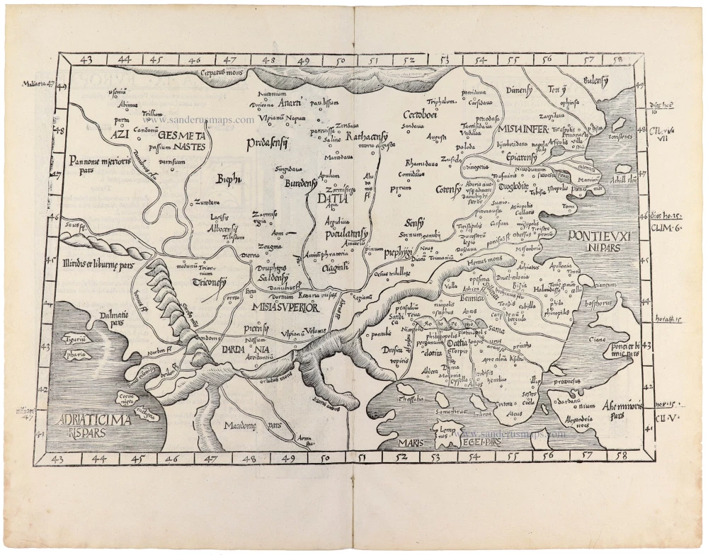
Tabula .IX. Europae. [Title on verso] 1525
Southeastern Europe (Hungary, Rumania, Bulgaria, Bosphorus), by Lorenz Fries.
[Item number: 32717]

De expugnatione Co[n]sta[n]tinopolis. 1493
The siege of Constantinople in 1453, by Hartmann Schedel.
[Item number: 32744]