
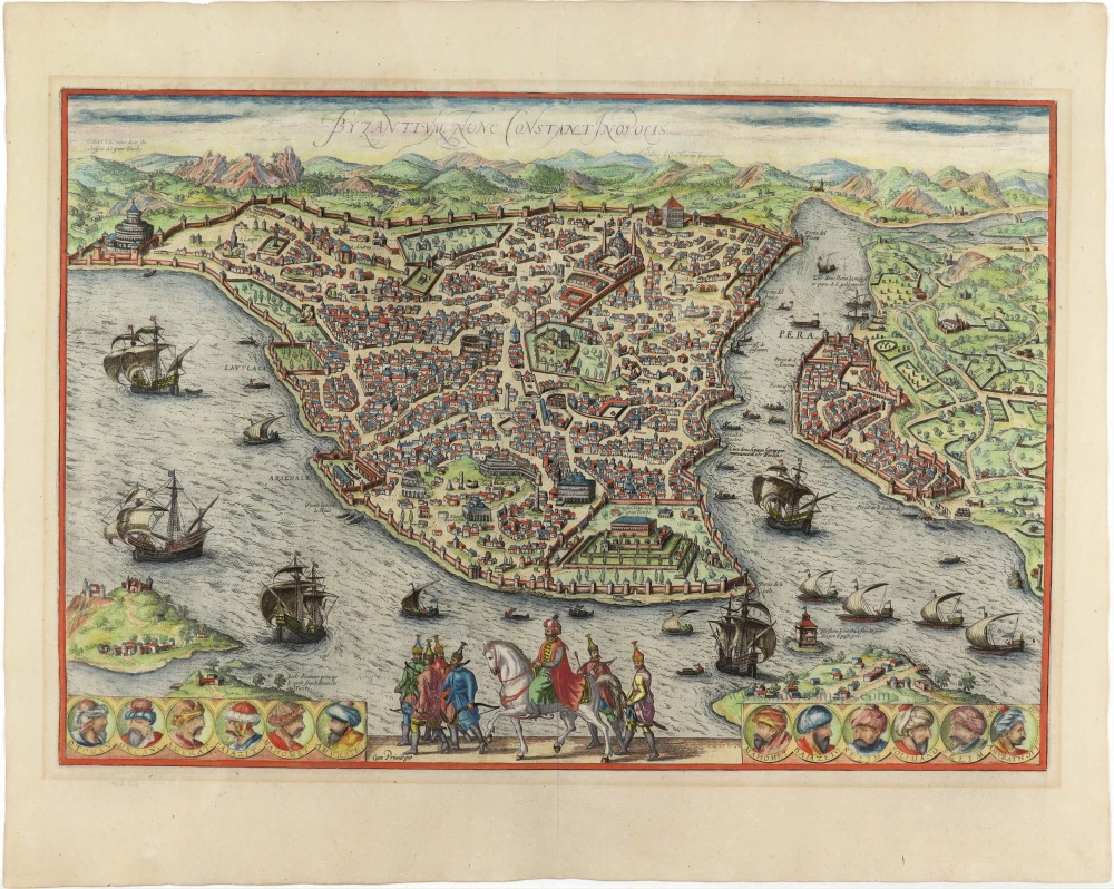
Istanbul (Constantinople), by Georg Braun and Frans Hogenberg. 1593
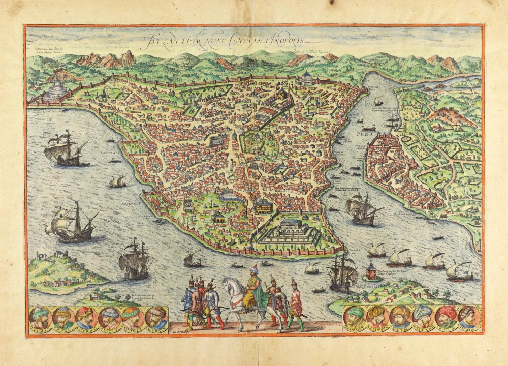


The city view includes the monuments of Saint Sophia and Topkapi Palace. Twelve vignettes of Ottoman sultans line the bottom margin, including portraits of Soliman the Magnificent and Selim. Numerous ships in Bosphorus and Golden Horn. Mounted Sultan with entourage at bottom centre.
CAPTION: Byzanz, now Constantinople.
COMMENTARY BY BRAUN: "Byzantium is a central place because no one can travel to Asia or Europe without the city's consent since the city is like a bridge or a gate for one part of the world. The sea binds it on three sides: to the north, the arm of the Bosporus, which belongs to Europe and is called Cornus (Horn). To the east is the Bosporus Strait; to the south is the Sea of Marmara."
Constantinople is shown from a birds-eye perspective from the east. The view looks directly down upon the new palace within its 200-acre park built by Sultan Mehmed II in 1453, immediately after the city's conquest; since the 18th century, it has been called the Topkapi Palace. Beside it, on the left, stands Hagia Sofia, the coronation church of the Byzantine emperors. It was turned into a mosque when Constantinople fell and given four minarets, still visible on the plate. Further left again are Roman ruins, including obelisks and an amphitheatre. The city was founded in 668 BC under the name of Byzantion (Byzantium) by the Greeks, for whom the Bosporus Strait was already strategically important. Incorporated into the Roman Empire under Vespasian in AD 324, the city was made the capital of the Eastern Empire by Emperor Constantine and renamed Constantinople. The 11 medallions along the lower edge contain the portraits of all the sultans, from the founder of the Ottoman Empire, Osman I, up to the current ruler of the day, Selim II. The name Istanbul was already used in Ottoman times but would replace Constantinople as the city's official name only in 1930. With a population of some ten million, Istanbul is today the biggest city in Turkey. (Taschen)
Braun G. & Hogenberg F. and the Civitates Orbis Terrarum.
The Civitates Orbis Terrarum, also known as the 'Braun & Hogenberg', is a six-volume town atlas and the most excellent book of town views and plans ever published: 363 engravings, sometimes beautifully coloured. It was one of the best-selling works in the last quarter of the 16th century. Georg Braun, a skilled writer, wrote the text accompanying the plans and views on the verso. Many plates were engraved after the original drawings of a professional artist, Joris Hoefnagel (1542-1600). The first volume was published in Latin in 1572 and the sixth in 1617. Frans Hogenberg, a talented engraver, created the tables for volumes I through IV, and Simon van den Neuwel made those for volumes V and VI. Other contributors were cartographers Daniel Freese and Heinrich Rantzau, who provided valuable geographical information. Works by Jacob van Deventer, Sebastian Münster, and Johannes Stumpf were also used as references. Translations appeared in German and French, making the atlas accessible to a wider audience.
Since its original publication of volume 1 in 1572, the Civitates Orbis Terrarum has left an indelible mark on the history of cartography. The first volume was followed by seven more editions in 1575, 1577, 1582, 1588, 1593, 1599, and 1612. Vol.2, initially released in 1575, saw subsequent editions in 1597 and 1612. The subsequent volumes, each a treasure trove of historical insights, graced the world in 1581, 1588, 1593, 1599, and 1606. The German translation of the first volume, a testament to its widespread appeal, debuted in 1574, followed by the French edition in 1575.
Several printers were involved: Theodor Graminaeus, Heinrich von Aich, Gottfried von Kempen, Johannis Sinniger, Bertram Buchholtz, and Peter von Brachel, all of whom worked in Cologne.
Georg Braun (1541-1622)
Georg Braun, the author of the text accompanying the plans and views in the Civitates Orbis Terrarum, was born in Cologne in 1541. After his studies in Cologne, he entered the Jesuit Order as a novice, indicating his commitment to learning and intellectual pursuits. In 1561, he obtained his bachelor's degree; in 1562, he received his Magister Artium, further demonstrating his academic achievements. Although he left the Jesuit Order, he continued his studies in theology, gaining a licentiate in theology. His theological background likely influenced the content and tone of the text in the Civitates Orbis Terrarum, adding a unique perspective to the work.
Frans Hogenberg (1535-1590)
Frans Hogenberg was a Flemish and German painter, engraver, and mapmaker. He was born in Mechelen as the son of Nicolaas Hogenberg.
By the end of the 1560s, Frans Hogenberg was employed upon Abraham Ortelius's Theatrum Orbis Terrarum, published in 1570; he is named an engraver of numerous maps. In 1568, he was banned from Antwerp by the Duke of Alva and travelled to London, where he stayed a few years before emigrating to Cologne. He immediately embarked on his two most important works, the Civitates, published in 1572 and the Geschichtsblätter, which appeared in several series from 1569 until about 1587.
Thanks to large-scale projects like the Geschichtsblätter and the Civitates, Hogenberg's social circumstances improved with each passing year. He died as a wealthy man in Cologne in 1590.
Byzantium nunc Constantinopolis.
Item Number: 30239 Authenticity Guarantee
Category: Antique maps > Asia > Turkey - Cyprus
Istanbul (Constantinople), by Georg Braun and Frans Hogenberg.
Title: Byzantium nunc Constantinopolis.
Cum Privilegio.
Date of the first edition: 1572.
Date of this map: 1593.
Copper engraving, printed on paper.
Image size: 330 x 485mm (12.99 x 19.09 inches).
Sheet size: 410 x 554mm (16.14 x 21.81 inches).
Verso: French text.
Condition: Original coloured, excellent.
Condition Rating: A+.
From: Braun G. & Hogenberg F. Théatre des Cités du Monde. Premier Volume. Cologne, Gottfried von Kempen (?), c. 1593. (Van der Krogt 41:3.1)
The city view includes the monuments of Saint Sophia and Topkapi Palace. Twelve vignettes of Ottoman sultans line the bottom margin, including portraits of Soliman the Magnificent and Selim. Numerous ships in Bosphorus and Golden Horn. Mounted Sultan with entourage at bottom centre.
CAPTION: Byzanz, now Constantinople.
COMMENTARY BY BRAUN: "Byzantium is a central place because no one can travel to Asia or Europe without the city's consent since the city is like a bridge or a gate for one part of the world. The sea binds it on three sides: to the north, the arm of the Bosporus, which belongs to Europe and is called Cornus (Horn). To the east is the Bosporus Strait; to the south is the Sea of Marmara."
Constantinople is shown from a birds-eye perspective from the east. The view looks directly down upon the new palace within its 200-acre park built by Sultan Mehmed II in 1453, immediately after the city's conquest; since the 18th century, it has been called the Topkapi Palace. Beside it, on the left, stands Hagia Sofia, the coronation church of the Byzantine emperors. It was turned into a mosque when Constantinople fell and given four minarets, still visible on the plate. Further left again are Roman ruins, including obelisks and an amphitheatre. The city was founded in 668 BC under the name of Byzantion (Byzantium) by the Greeks, for whom the Bosporus Strait was already strategically important. Incorporated into the Roman Empire under Vespasian in AD 324, the city was made the capital of the Eastern Empire by Emperor Constantine and renamed Constantinople. The 11 medallions along the lower edge contain the portraits of all the sultans, from the founder of the Ottoman Empire, Osman I, up to the current ruler of the day, Selim II. The name Istanbul was already used in Ottoman times but would replace Constantinople as the city's official name only in 1930. With a population of some ten million, Istanbul is today the biggest city in Turkey. (Taschen)
Braun G. & Hogenberg F. and the Civitates Orbis Terrarum.
The Civitates Orbis Terrarum, also known as the 'Braun & Hogenberg', is a six-volume town atlas and the most excellent book of town views and plans ever published: 363 engravings, sometimes beautifully coloured. It was one of the best-selling works in the last quarter of the 16th century. Georg Braun, a skilled writer, wrote the text accompanying the plans and views on the verso. Many plates were engraved after the original drawings of a professional artist, Joris Hoefnagel (1542-1600). The first volume was published in Latin in 1572 and the sixth in 1617. Frans Hogenberg, a talented engraver, created the tables for volumes I through IV, and Simon van den Neuwel made those for volumes V and VI. Other contributors were cartographers Daniel Freese and Heinrich Rantzau, who provided valuable geographical information. Works by Jacob van Deventer, Sebastian Münster, and Johannes Stumpf were also used as references. Translations appeared in German and French, making the atlas accessible to a wider audience.
Since its original publication of volume 1 in 1572, the Civitates Orbis Terrarum has left an indelible mark on the history of cartography. The first volume was followed by seven more editions in 1575, 1577, 1582, 1588, 1593, 1599, and 1612. Vol.2, initially released in 1575, saw subsequent editions in 1597 and 1612. The subsequent volumes, each a treasure trove of historical insights, graced the world in 1581, 1588, 1593, 1599, and 1606. The German translation of the first volume, a testament to its widespread appeal, debuted in 1574, followed by the French edition in 1575.
Several printers were involved: Theodor Graminaeus, Heinrich von Aich, Gottfried von Kempen, Johannis Sinniger, Bertram Buchholtz, and Peter von Brachel, all of whom worked in Cologne.
Georg Braun (1541-1622)
Georg Braun, the author of the text accompanying the plans and views in the Civitates Orbis Terrarum, was born in Cologne in 1541. After his studies in Cologne, he entered the Jesuit Order as a novice, indicating his commitment to learning and intellectual pursuits. In 1561, he obtained his bachelor's degree; in 1562, he received his Magister Artium, further demonstrating his academic achievements. Although he left the Jesuit Order, he continued his studies in theology, gaining a licentiate in theology. His theological background likely influenced the content and tone of the text in the Civitates Orbis Terrarum, adding a unique perspective to the work.
Frans Hogenberg (1535-1590)
Frans Hogenberg was a Flemish and German painter, engraver, and mapmaker. He was born in Mechelen as the son of Nicolaas Hogenberg.
By the end of the 1560s, Frans Hogenberg was employed upon Abraham Ortelius's Theatrum Orbis Terrarum, published in 1570; he is named an engraver of numerous maps. In 1568, he was banned from Antwerp by the Duke of Alva and travelled to London, where he stayed a few years before emigrating to Cologne. He immediately embarked on his two most important works, the Civitates, published in 1572 and the Geschichtsblätter, which appeared in several series from 1569 until about 1587.
Thanks to large-scale projects like the Geschichtsblätter and the Civitates, Hogenberg's social circumstances improved with each passing year. He died as a wealthy man in Cologne in 1590.
Related items
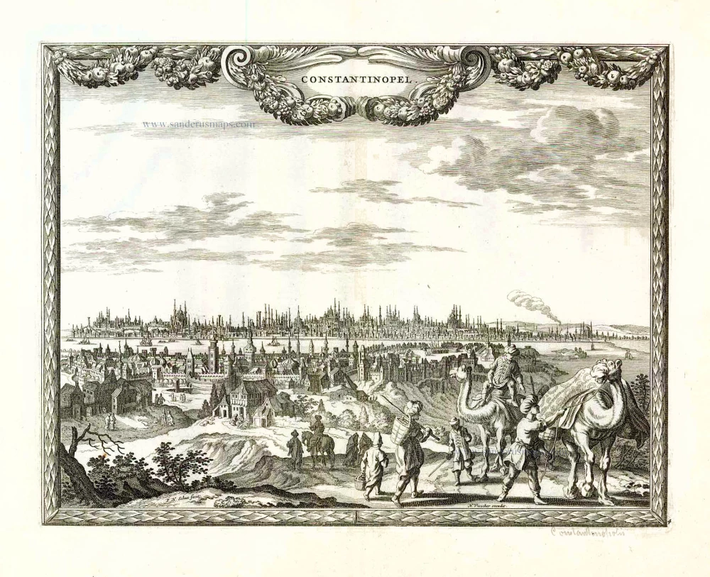
Contantinopel. 1658/60
Istanbul (Constantinople), by N. Visscher & P.H. Schut.
[Item number: 26629]
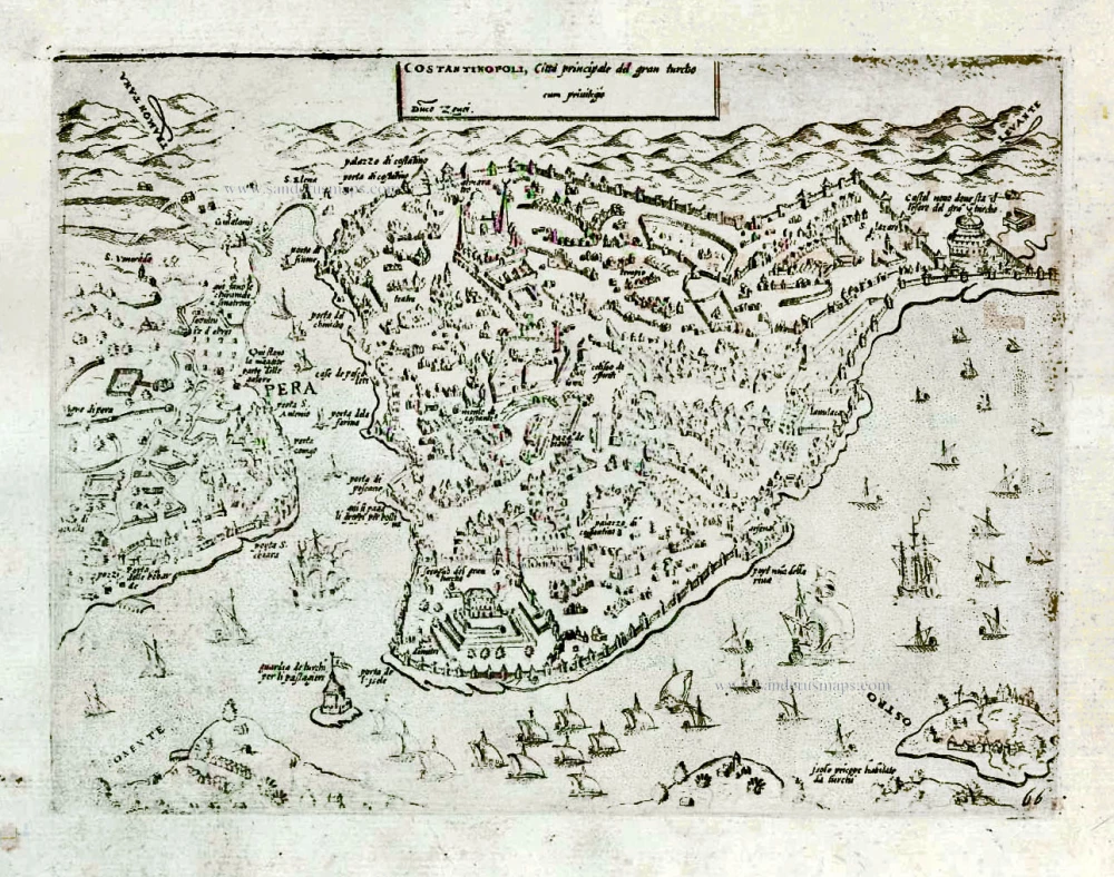
Costatinopoli, Città principale del gran turcho. After 1575
Istanbul (Constantinople) by Giovanni Francesco Camocio
[Item number: 27578]
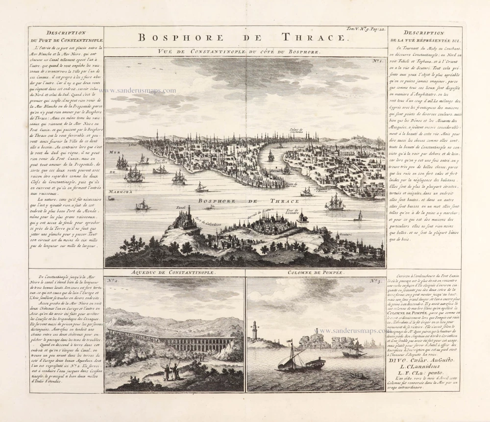
Bosphore de Thrace. 1719
Bosphorus with three views of Constantinople, by Zacharias Châtelain.
[Item number: 29385]
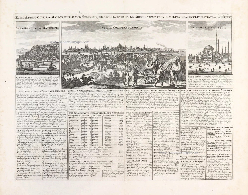
Etat Abregé de la Maison du Grand Seigneur, de ses Revenus et le Gouvernement Civil, Militaire et Ecclesiastique de cet Empire.. 1714
Constantinople, by Zacharias Châtelain.
[Item number: 29398]
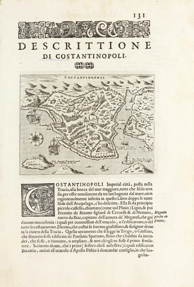
Costantinopoli. - [Above map :] Descrittione di Constantinopoli. 1590
Istanbul (Constantinople) by Thomasso Porcacchi.
[Item number: 29830]
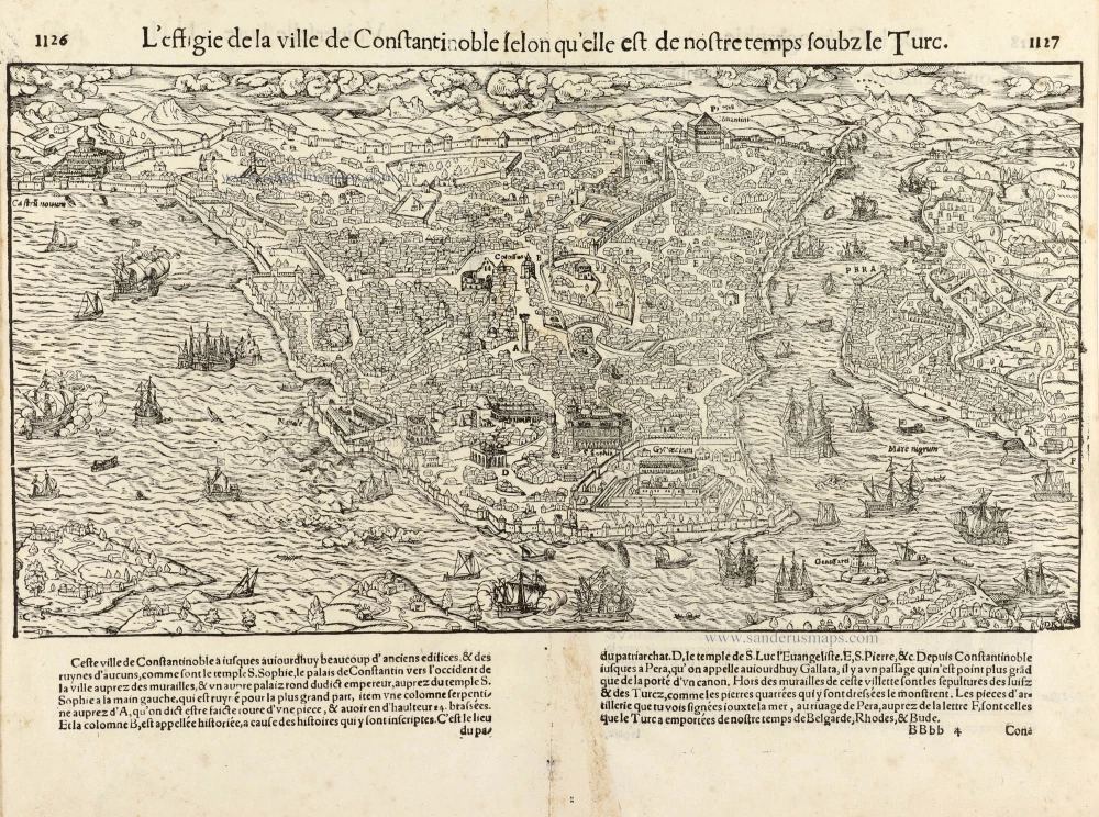
L'effigie de la ville de Constantinoble selon qu'elle est de nostre temps soubz le Turc. 1568
Istanbul (Constantinople), by Sebastian Münster.
[Item number: 30594]
Byzantium nunc Constantinopolis. 1593
Istanbul (Constantinople), by Georg Braun and Frans Hogenberg.
[Item number: 30958]
new