
Southeastern Europe - Turkey by Homann Heirs 1752-1775
The Homann Family: Masters of German Cartography and Publishing
The Homann family stands as one of the most significant names in the history of German cartography and publishing. Their maps, atlases, and geographic works not only shaped contemporary understanding of the world during the 18th century but also left an enduring legacy in the fields of geography, engraving, and scholarly publishing.
The family's prominence began with Johann Baptist Homann (1664–1724), a native of Oberkammlach in Bavaria. Initially trained in law and theology, Johann Baptist later turned to engraving and cartography — a field that was flourishing amid the Age of Discovery and the growing demand for precise geographic knowledge.
In 1702, he founded his own publishing house in Nürnberg, a city then renowned for its vibrant intellectual, artistic, and scientific community. Nuremberg’s rich tradition of printmaking and map production provided fertile ground for Homann's enterprise.
Johann Baptist Homann quickly rose to prominence as one of Germany’s leading cartographers and publishers. His works combined technical accuracy, artistic merit, and rich ornamentation, often embellished with elaborate cartouches, mythological scenes, and heraldic symbols.
In 1715, Homann was appointed Imperial Geographer to the Holy Roman Emperor Charles VI. He obtained the "Imperial Privilege" (Privilegium Imperialis). This prestigious title solidified his status and bestowed upon his publishing house both credibility and influence. His most famous works include:
- Atlas Novus Terrarum Orbis (1707) — an early and ambitious atlas project.
- Grosser Atlas über die ganze Welt (1716) — one of the most crucial German world atlases of the early 18th century.
Homann’s maps covered both European and global territories, including the Americas, Asia, and Africa, reflecting contemporary geographical knowledge and political boundaries.
The Homann Heirs (Homannische Erben)
After Johann Baptist Homann died in 1724, his son Johann Christoph Homann (1703–1730) briefly took over the business. However, Johann Christoph died at a young age, and the enterprise was then continued under the name Homännische Erben ("Homann Heirs"), a partnership of family members and associates.
Despite the loss of its founder, the firm remained highly productive and influential for several decades. The Homann Heirs continued to publish atlases, wall maps, city views, and geographical treatises well into the late 18th century. Their catalogue included works by noted cartographers such as Johann Matthias Hase, Leonhard Euler, and Tobias Conrad Lotter.
The Homann publishing house played a crucial role in disseminating geographic and scientific knowledge during the Enlightenment. Their maps combined artistry with empirical detail and were sought after by scholars, navigators, governments, and collectors.
Several of their works are now prized as valuable historical artefacts, housed in museums, libraries, and private collections around the world. The Homann Heirs' firm gradually declined by the end of the 18th century, overtaken by newer publishing houses and changing technologies, but their contribution to the cartographic tradition remains significant.
The Homann family’s name is indelibly linked to the golden age of German cartography. Through meticulous craftsmanship and a keen sense of visual storytelling, they charted the known world of their time, leaving a remarkable record of early modern geography. Today, their maps not only inform historians of cartography but also captivate collectors and enthusiasts for their aesthetic beauty and historical value.
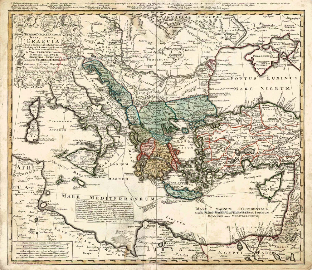
Imperii Turcici Europaei Terra in Primis Graecia.
Item Number: 26592 Authenticity Guarantee
Category: Antique maps > Asia > Turkey - Cyprus
Old, antique map of the Ottoman Empire, by Homann Heirs.
Cartographer: J.C. Harenberg
Date of the first edition: 1741
Date of this map: 1752-1775
Date on map: 1741
Copper engraving, printed on paper.
Size (not including margins): 50.5 x 57.5cm (19.7 x 22.4 inches)
Verso: Blank
Condition: Original coloured, lower centrefold, reinforced, small worm trace at bottom.
Condition Rating: A
References: Zacharakis, #1613/1067.
From: Major Atlas Scholasticus. Nürnberg, 1752-1775.
The Homann Family: Masters of German Cartography and Publishing
The Homann family stands as one of the most significant names in the history of German cartography and publishing. Their maps, atlases, and geographic works not only shaped contemporary understanding of the world during the 18th century but also left an enduring legacy in the fields of geography, engraving, and scholarly publishing.
The family's prominence began with Johann Baptist Homann (1664–1724), a native of Oberkammlach in Bavaria. Initially trained in law and theology, Johann Baptist later turned to engraving and cartography — a field that was flourishing amid the Age of Discovery and the growing demand for precise geographic knowledge.
In 1702, he founded his own publishing house in Nürnberg, a city then renowned for its vibrant intellectual, artistic, and scientific community. Nuremberg’s rich tradition of printmaking and map production provided fertile ground for Homann's enterprise.
Johann Baptist Homann quickly rose to prominence as one of Germany’s leading cartographers and publishers. His works combined technical accuracy, artistic merit, and rich ornamentation, often embellished with elaborate cartouches, mythological scenes, and heraldic symbols.
In 1715, Homann was appointed Imperial Geographer to the Holy Roman Emperor Charles VI. He obtained the "Imperial Privilege" (Privilegium Imperialis). This prestigious title solidified his status and bestowed upon his publishing house both credibility and influence. His most famous works include:
- Atlas Novus Terrarum Orbis (1707) — an early and ambitious atlas project.
- Grosser Atlas über die ganze Welt (1716) — one of the most crucial German world atlases of the early 18th century.
Homann’s maps covered both European and global territories, including the Americas, Asia, and Africa, reflecting contemporary geographical knowledge and political boundaries.
The Homann Heirs (Homannische Erben)
After Johann Baptist Homann died in 1724, his son Johann Christoph Homann (1703–1730) briefly took over the business. However, Johann Christoph died at a young age, and the enterprise was then continued under the name Homännische Erben ("Homann Heirs"), a partnership of family members and associates.
Despite the loss of its founder, the firm remained highly productive and influential for several decades. The Homann Heirs continued to publish atlases, wall maps, city views, and geographical treatises well into the late 18th century. Their catalogue included works by noted cartographers such as Johann Matthias Hase, Leonhard Euler, and Tobias Conrad Lotter.
The Homann publishing house played a crucial role in disseminating geographic and scientific knowledge during the Enlightenment. Their maps combined artistry with empirical detail and were sought after by scholars, navigators, governments, and collectors.
Several of their works are now prized as valuable historical artefacts, housed in museums, libraries, and private collections around the world. The Homann Heirs' firm gradually declined by the end of the 18th century, overtaken by newer publishing houses and changing technologies, but their contribution to the cartographic tradition remains significant.
The Homann family’s name is indelibly linked to the golden age of German cartography. Through meticulous craftsmanship and a keen sense of visual storytelling, they charted the known world of their time, leaving a remarkable record of early modern geography. Today, their maps not only inform historians of cartography but also captivate collectors and enthusiasts for their aesthetic beauty and historical value.
Related items

Imperium Turcicum in Europa, Asia et Africa, divisum in sua Regna et Regiones, nempe Graeciam, Natoliam, Armeniam, Arabiam, Aegyptum, Regna Algeriae, Tunetanum, Tripoleos et Barcae, cum reliquis adjacentibus regionibus. c. 1700
Ottoman Empire by Gerard and Leonard Valck.
[Item number: 28322]

Pamphilia et Pisidia. 1670
Pamphylia & Pisidia (Anatolia - Turkey) by Pierre Mariette.
[Item number: 30022]

Lycaonia In Minores Regiones seu Tractus distincta; Et in ea Romana Itineraria, ex Tabula Peutingeriana et ex Antonino descripta. 1676
Lycaonia (Central Turkey) by Guillaume Sanson.
[Item number: 30023]

*** Scarce first edition ***
Ponti Pars, Ad Halym, Iridem Thermodontemq[ue]; Fluvios Sita; quam Heroicis Temporibus Amazones Romanorum Aetate Mithridatis Regnum Nobilitarunt: quae tandem Provincia Romanorum facta Pontus Galaticus mox Hellenopontus dicta et in Minores Regiones distincta; et in ea Romana Itineraria ex Tabula Peutingeriana, et ex Antonino descripta. 1676
Ancient Northern Turkey by Guillaume Sanson.
[Item number: 30024]

*** Rare first edition ***
Tabula Itineris Decies Mille Graecorum sub Cyro contra fratrem suum Artaxerxem Regem Persarum. 1653
Asia Minor through to Armenia and Babylon by Pierre Duval.
[Item number: 30038]

Anaplus Bosphori Thracii. 1665
Bosporus by Guillaume Sanson.
[Item number: 30040]

Natolia quae olim Asia Minor. ca. 1658-1663
Turkey by Nicolas Sanson, published by Pierre Mariette.
[Item number: 30046]

Scarce map
Europam sive Celticam Veterem c. 1630-1650
Europe by Evert van Hamersveldt, published by Johannes Janssonius.
[Item number: 30838]

Fanar nel' Arcipelago. c. 1690
Fanar (Istanbul - Turkey) by J. Peeters.
[Item number: 31381]

Tabula nova Asiae minoris. 1525
Turkey, by Lorenz Fries.
[Item number: 32689]

Natoliae sive Asia Minor. c. 1630-1650
Turkey & Cyprus, by Jodocus Hondius.
[Item number: 33148]
new