
The Sitting Leo Belgicus by C.J. Visscher. c. 1611
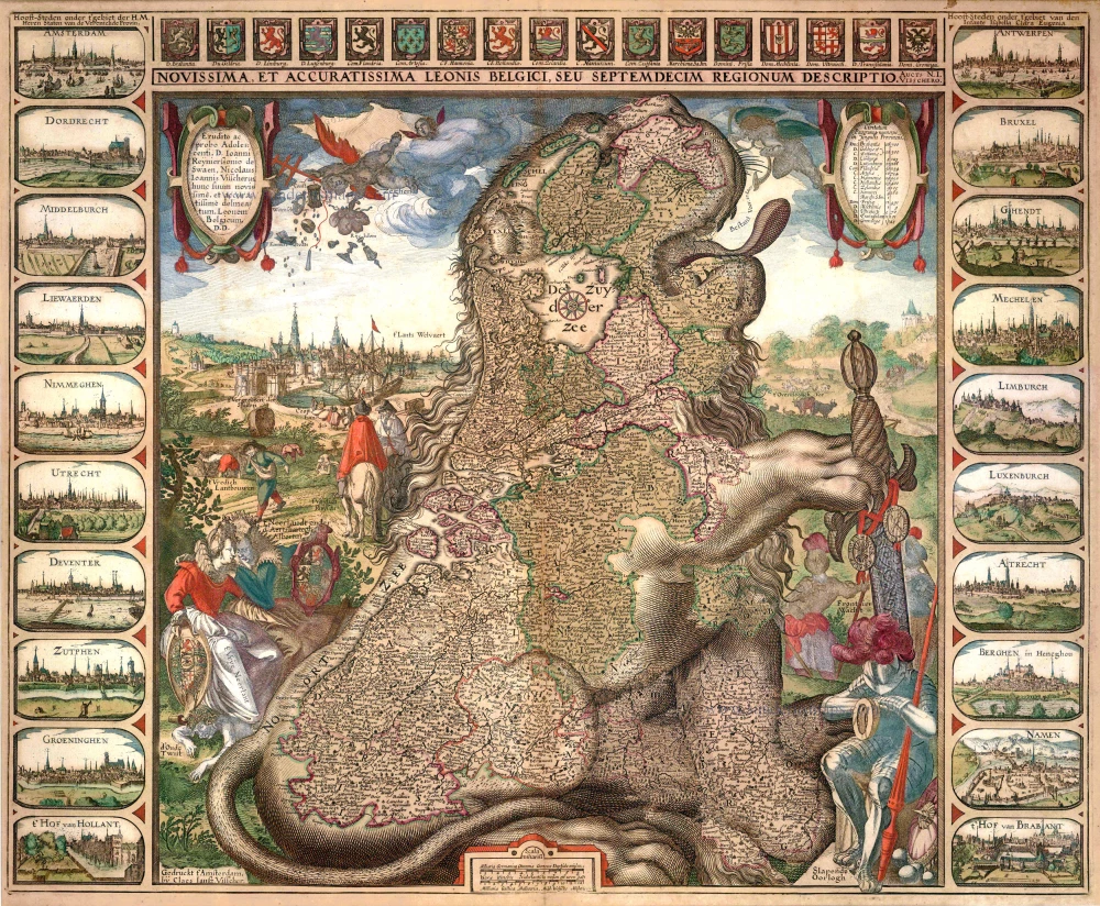
Exquisite map of the sitting lion, which van der Heijden calls "One of the peaks of 17th-century cartography". C.J. Visscher made this map on the occasion of the Twelve Years' Truce (1609-1621) between Spain and the United Netherlands, as appears from many a text on the map. Date: In or between 1611 and 1621. Visscher's map in the form of a sitting lion is an emblematical representation of the Twelve Years' Truce (1609-21) between Spain and the Seven United Provinces. The lion is surrounded by a great number of texts and symbols relevant to this event. To the left t'Vrije Neerlant (The Liberated Netherlands) together with t'Neerlandt onder d'Aertshartogh Albertus (The Netherlands under Archduke Albertus) trample d'Oude Twist (Old Conflict). In the sky a cherub named Zeghen (Blessing) strewing Rijckdom (Wealth), Veilighe Tijdt (Safe Time), Const en Wetenschap (Art and Science) and Kennisse Goodts (Theology) over the town and country below, where inscriptions refer to t' Lants Welvaert (Prosperity of the Country), t Vergrooten der Steden (The Growth of the Towns), Coophandel (Trade), t'Vredich Lantbouwen (Peaceful Agriculture) and t Veijlich Reijsen (Safe Travel). In the sky to the right is an angel with a trumpet of fame and the words Bestant voor 12 Iaer (12-Year Truce). Below this is a landscape with t'Overvloedich Vee (Abundant Cattle). The sitting lion has his sword sheathed, decorated with two seals, one with the seven arrows for the northern provinces and the other with the Burgundian cross for the southern provinces, and the inscriptions of Duodecim annos and voor twaelf jaren (for twelve years). In the lower right corner is a depiction of the Slapende Oorlogh, an allegorical figure of a Sleeping Mars. The first edition of this map (of which only 2 copies are known), bears an imprint placed in the lower left corner. Since it gives Visscher's address as inde Calverstraet, where he lived from 1611 onwards, the map must have been published in this year or later (in any case before 1621, the end of the Twelve Years' Truce). The map is framed by decorative borders on three sides. Above the title strip runs a small frieze with coat of arms of the provinces, each with a caption above it. The two side borders contain town views, to the left the residence in The Hague and nine town views in the Northern Netherlands, to the right the residence in Brussels and nine town views in the Southern Netherlands. These town views are mostly faithful copies of the larger ones designed by Claes Jansz Visscher for Blaeu's 1608 wall map of the Seventeen Provinces. The map was engraved by an artist in Visscher's workshop, and the allegorical scenes surrounding the map were etched by Visscher himself. The town views were etched by another hand, probably by Pieter van den Keere. The Netherlands, depicted in the form of a lion originated with the Austrian Michael von Aitzing (c. 1530-98), who inserted in his book De Leone Belgico (1583) a Leo Belgicus map, engraved by Frans Hogenberg. In the preface of this work von Aitzing explains why he chose this particular title and inserted the lion map. He explains that Caesar mentioned in his "Commentaries" that the 'Belgae' were the strongest tribes, and he therefore decided - partly because of the religious conflicts in the war against Spain - to introduce the Netherlands in the shape of a lion.
The Visscher Family
For nearly a century, the members of the Visscher family were essential art dealers and map publishers in Amsterdam.
Claes Jansz. Visscher, or N.J. Piscator (1587-1652)
Claes Jansz. Vischer bought a house in Amsterdam, 'de gulden Bors', on the crucial Kalverstraat and changed the name into "In de Visscher"; under this title, the shop was to flourish for many years.
He was famous for his engravings and etchings of Dutch landscapes and 'historical scenes', such as sieges, battles, etc. These 'historical scenes' were considered contemporary illustrated news items, especially e.g. that of 'the Eighty Years' War'.
For the publication of his first atlas, he bought copperplates of the atlas Germania Inferior by Pieter van den Keere (1623).
In 1649, he published an atlas entitled Tabularum Geographicarum Contractarum, containing the same maps as Langenes' Caert Thresoor, for which Visscher had only new title pages engraved.
Claes Jansz. Visscher died in 1652. His wife, Neeltjen Florisdr., had already died in 1640. They had seven children, four of whom were still alive at Claes Jansz.'s death. One was Nicolaes Visscher I, who was to continue his father's business.
Nicolaes Visscher I (1618-1679)
Nicolaes Visscher I partnered with his father, continued the business, and stayed on the Kalverstraat 'in de Visscher' till his death.
In about 1657, the first edition of his Atlas Contractus Orbis Terrarum appeared.
Between 1664 and 1677, several editions of his Atlas Contractus appeared without a printed index, for these atlases had no fixed contents but were composed according to the buyer's financial leaping pole.
In May 1664, Nicolaes Visscher was admitted as a member of the Booksellers' Guild of his town. In July 1677, he was granted a patent of the States of Holland and West-Friesland for printing and publishing maps and atlases for 15 years.
After this, he again published an Atlas Contractus with a printed index. At about the same time, he also brought out an Atlas Minor.
Nicolaes Visscher II (1649-1702)
Nicolaes Visscher II inherited the 'shop' from his father. To obtain a new privilege, he applied to the States of Holland and West-Friesland in 1682 for a patent for printing and publishing maps. This patent was granted to him the same year. He moved the firm to the Dam, but it kept the same signboard: "In de Visscher".
Around 1683, he published his first Atlas Minor with a printed index of 91 maps. In 1684, an atlas Germania Inferior appeared. Till 1697, he published another number of atlases. He used his grandfather's (Claes Jansz.) maps less often now and relied more and more on his own.
The wars waged at this time initiated the compilation of maps of the countries where the armies operated. Many war maps were included in the various editions of his Atlas Minor.
After Nicolaes's death, his wife, Elizabeth Verseyl, published all the war maps as an atlas under the title De Stoel des Oorlogs in de Wereld (The seat of war in the world).
The widow of Nicolaes Visscher II (?-1726)
His widow continued the business energetically, and by her hand, under the name of her deceased husband, numerous atlases appeared, e.g., several editions of the Atlas Minor, an Atlas Maior and De Stoel des Oorlogs. The shop enjoyed a high reputation due to the assortment's incredible variety. Not only 'Visscher' maps but also maps of other publishers were obtainable. With the death of Elizabeth Verseyl in 1726, the last descendant died of a great map- and atlas-publishing firm in Amsterdam.
Novissima, et Accuratissima Leonis Belgici, seu Septemdecim Regionum Descriptio. Auct: N.I. Visschero.
Item Number: 24558 Authenticity Guarantee
Category: Antique maps > Curiosities
Antique map - The Sitting Leo Belgicus by C.J. Visscher.
Exquisite map of the sitting lion, which van der Heijden calls "One of the peaks of 17th-century cartography". C.J. Visscher made this map on the occasion of the Twelve Years' Truce (1609-1621) between Spain and the United Netherlands, as appears from many a text on the map.
Date: In or between 1611 and 1621.
Visscher's map in the form of a sitting lion is an emblematical representation of the Twelve Years' Truce (1609-21) between Spain and the Seven United Provinces. The lion is surrounded by a great number of texts and symbols relevant to this event. To the left t'Vrije Neerlant (The Liberated Netherlands) together with t'Neerlandt onder d'Aertshartogh Albertus (The Netherlands under Archduke Albertus) trample d'Oude Twist (Old Conflict). In the sky a cherub named Zeghen (Blessing) strewing Rijckdom (Wealth), Veilighe Tijdt (Safe Time), Const en Wetenschap (Art and Science) and Kennisse Goodts (Theology) over the town and country below, where inscriptions refer to t' Lants Welvaert (Prosperity of the Country), t Vergrooten der Steden (The Growth of the Towns), Coophandel (Trade), t'Vredich Lantbouwen (Peaceful Agriculture) and t Veijlich Reijsen (Safe Travel). In the sky to the right is an angel with a trumpet of fame and the words Bestant voor 12 Iaer (12-Year Truce). Below this is a landscape with t'Overvloedich Vee (Abundant Cattle). The sitting lion has his sword sheathed, decorated with two seals, one with the seven arrows for the northern provinces and the other with the Burgundian cross for the southern provinces, and the inscriptions of Duodecim annos and voor twaelf jaren (for twelve years). In the lower right corner is a depiction of the Slapende Oorlogh, an allegorical figure of a Sleeping Mars.
The first edition of this map (of which only 2 copies are known), bears an imprint placed in the lower left corner. Since it gives Visscher's address as inde Calverstraet, where he lived from 1611 onwards, the map must have been published in this year or later (in any case before 1621, the end of the Twelve Years' Truce).
The map is framed by decorative borders on three sides. Above the title strip runs a small frieze with coat of arms of the provinces, each with a caption above it. The two side borders contain town views, to the left the residence in The Hague and nine town views in the Northern Netherlands, to the right the residence in Brussels and nine town views in the Southern Netherlands. These town views are mostly faithful copies of the larger ones designed by Claes Jansz Visscher for Blaeu's 1608 wall map of the Seventeen Provinces. The map was engraved by an artist in Visscher's workshop, and the allegorical scenes surrounding the map were etched by Visscher himself. The town views were etched by another hand, probably by Pieter van den Keere.
The Netherlands, depicted in the form of a lion originated with the Austrian Michael von Aitzing (c. 1530-98), who inserted in his book De Leone Belgico (1583) a Leo Belgicus map, engraved by Frans Hogenberg. In the preface of this work von Aitzing explains why he chose this particular title and inserted the lion map. He explains that Caesar mentioned in his "Commentaries" that the 'Belgae' were the strongest tribes, and he therefore decided - partly because of the religious conflicts in the war against Spain - to introduce the Netherlands in the shape of a lion.
Copper engraving
Size: 47 x 57.5cm (18.3 x 22.3 inches)
Verso: Blank
Condition: Old coloured, excellent.
Condition Rating: A
References: Van der Heijden (Leo Belg), 5.2; Schilder 6, 53.2.
Separate publication, second state (of two), only one copy known of the first state.
Exquisite map of the sitting lion, which van der Heijden calls "One of the peaks of 17th-century cartography". C.J. Visscher made this map on the occasion of the Twelve Years' Truce (1609-1621) between Spain and the United Netherlands, as appears from many a text on the map. Date: In or between 1611 and 1621. Visscher's map in the form of a sitting lion is an emblematical representation of the Twelve Years' Truce (1609-21) between Spain and the Seven United Provinces. The lion is surrounded by a great number of texts and symbols relevant to this event. To the left t'Vrije Neerlant (The Liberated Netherlands) together with t'Neerlandt onder d'Aertshartogh Albertus (The Netherlands under Archduke Albertus) trample d'Oude Twist (Old Conflict). In the sky a cherub named Zeghen (Blessing) strewing Rijckdom (Wealth), Veilighe Tijdt (Safe Time), Const en Wetenschap (Art and Science) and Kennisse Goodts (Theology) over the town and country below, where inscriptions refer to t' Lants Welvaert (Prosperity of the Country), t Vergrooten der Steden (The Growth of the Towns), Coophandel (Trade), t'Vredich Lantbouwen (Peaceful Agriculture) and t Veijlich Reijsen (Safe Travel). In the sky to the right is an angel with a trumpet of fame and the words Bestant voor 12 Iaer (12-Year Truce). Below this is a landscape with t'Overvloedich Vee (Abundant Cattle). The sitting lion has his sword sheathed, decorated with two seals, one with the seven arrows for the northern provinces and the other with the Burgundian cross for the southern provinces, and the inscriptions of Duodecim annos and voor twaelf jaren (for twelve years). In the lower right corner is a depiction of the Slapende Oorlogh, an allegorical figure of a Sleeping Mars. The first edition of this map (of which only 2 copies are known), bears an imprint placed in the lower left corner. Since it gives Visscher's address as inde Calverstraet, where he lived from 1611 onwards, the map must have been published in this year or later (in any case before 1621, the end of the Twelve Years' Truce). The map is framed by decorative borders on three sides. Above the title strip runs a small frieze with coat of arms of the provinces, each with a caption above it. The two side borders contain town views, to the left the residence in The Hague and nine town views in the Northern Netherlands, to the right the residence in Brussels and nine town views in the Southern Netherlands. These town views are mostly faithful copies of the larger ones designed by Claes Jansz Visscher for Blaeu's 1608 wall map of the Seventeen Provinces. The map was engraved by an artist in Visscher's workshop, and the allegorical scenes surrounding the map were etched by Visscher himself. The town views were etched by another hand, probably by Pieter van den Keere. The Netherlands, depicted in the form of a lion originated with the Austrian Michael von Aitzing (c. 1530-98), who inserted in his book De Leone Belgico (1583) a Leo Belgicus map, engraved by Frans Hogenberg. In the preface of this work von Aitzing explains why he chose this particular title and inserted the lion map. He explains that Caesar mentioned in his "Commentaries" that the 'Belgae' were the strongest tribes, and he therefore decided - partly because of the religious conflicts in the war against Spain - to introduce the Netherlands in the shape of a lion.
The Visscher Family
For nearly a century, the members of the Visscher family were essential art dealers and map publishers in Amsterdam.
Claes Jansz. Visscher, or N.J. Piscator (1587-1652)
Claes Jansz. Vischer bought a house in Amsterdam, 'de gulden Bors', on the crucial Kalverstraat and changed the name into "In de Visscher"; under this title, the shop was to flourish for many years.
He was famous for his engravings and etchings of Dutch landscapes and 'historical scenes', such as sieges, battles, etc. These 'historical scenes' were considered contemporary illustrated news items, especially e.g. that of 'the Eighty Years' War'.
For the publication of his first atlas, he bought copperplates of the atlas Germania Inferior by Pieter van den Keere (1623).
In 1649, he published an atlas entitled Tabularum Geographicarum Contractarum, containing the same maps as Langenes' Caert Thresoor, for which Visscher had only new title pages engraved.
Claes Jansz. Visscher died in 1652. His wife, Neeltjen Florisdr., had already died in 1640. They had seven children, four of whom were still alive at Claes Jansz.'s death. One was Nicolaes Visscher I, who was to continue his father's business.
Nicolaes Visscher I (1618-1679)
Nicolaes Visscher I partnered with his father, continued the business, and stayed on the Kalverstraat 'in de Visscher' till his death.
In about 1657, the first edition of his Atlas Contractus Orbis Terrarum appeared.
Between 1664 and 1677, several editions of his Atlas Contractus appeared without a printed index, for these atlases had no fixed contents but were composed according to the buyer's financial leaping pole.
In May 1664, Nicolaes Visscher was admitted as a member of the Booksellers' Guild of his town. In July 1677, he was granted a patent of the States of Holland and West-Friesland for printing and publishing maps and atlases for 15 years.
After this, he again published an Atlas Contractus with a printed index. At about the same time, he also brought out an Atlas Minor.
Nicolaes Visscher II (1649-1702)
Nicolaes Visscher II inherited the 'shop' from his father. To obtain a new privilege, he applied to the States of Holland and West-Friesland in 1682 for a patent for printing and publishing maps. This patent was granted to him the same year. He moved the firm to the Dam, but it kept the same signboard: "In de Visscher".
Around 1683, he published his first Atlas Minor with a printed index of 91 maps. In 1684, an atlas Germania Inferior appeared. Till 1697, he published another number of atlases. He used his grandfather's (Claes Jansz.) maps less often now and relied more and more on his own.
The wars waged at this time initiated the compilation of maps of the countries where the armies operated. Many war maps were included in the various editions of his Atlas Minor.
After Nicolaes's death, his wife, Elizabeth Verseyl, published all the war maps as an atlas under the title De Stoel des Oorlogs in de Wereld (The seat of war in the world).
The widow of Nicolaes Visscher II (?-1726)
His widow continued the business energetically, and by her hand, under the name of her deceased husband, numerous atlases appeared, e.g., several editions of the Atlas Minor, an Atlas Maior and De Stoel des Oorlogs. The shop enjoyed a high reputation due to the assortment's incredible variety. Not only 'Visscher' maps but also maps of other publishers were obtainable. With the death of Elizabeth Verseyl in 1726, the last descendant died of a great map- and atlas-publishing firm in Amsterdam.